Previous Year Paper

UGC NET Paper 2: Geography July 2018 (Previous Year Paper)

Held in 2018

100 questions120 minutes
With answers
Free

Paper last updated:

Practise under exam conditions

Take this paper as a timed mock test. Review your answers after you submit.

Attempt timed test

Questions & answers

Read the paper at your pace. Open an explanation when you need it.

Full Test (100 questions)

Question 1

Gutenberg discontinuity is found between the :

  1. AOption (a)

    Crust and mantle

  2. BOption (b)

    Mantle and Core

  3. COption (c)

    Upper Core and Lower Core

  4. DOption (d)

    Upper mantle and lower mantle

View answer & explanation

Correct answer

Answer: (b)B.

Mantle and Core

Why this answer is correct

Key Points

Interior structure of the earth:

  • Earth’s interior is made of different kinds of materials.
  • Each of those materials is different from the other by their physical and chemical properties, such as temperature, density etc.
  • Unique layers are there according to their characteristics inside the earth.
  • All those layers are separated from each other through a transition zone. These transition zones are called Discontinuities.

There are Five Discontinuities inside the earth.

  • Conrad Discontinuity:  
  • Conrad discontinuity A boundary within the Earth's continental crust that can be detected seismically at about 10–12 km depth, although exploratory deep drilling has failed to locate it.
  • The transition zone between SIAL and SIMA.
  • Mohorovicic Discontinuity: 
  • The Mohorovicic Discontinuity, or "Moho," is the boundary between the crust and the mantle.
  • The transition zone between the Crust and Mantle.
  • Repiti Discontinuity:
  • The portion of the mantle which is just below the lithosphere and asthenosphere, but above the core is called as Mesosphere.
  • The transition zone between the Outer mantle and Inner mantle.
  • Gutenberg Discontinuity:
  • The Gutenberg Discontinuity is a relatively low density (lower density) lower mantle with a relatively liquid (low density) outer core.
  • The transition zone between Mantle and Core.
  • Lehman Discontinuity:
  • ​The Lehmann discontinuity is an abrupt increase of P-wave and S-wave velocities at the depth of 220 km (140 mi), discovered by seismologist Inge Lehmann.
  • The transition zone between the Outer core and Inner core.

Hence, Gutenberg discontinuity is found between the Mantle and Core.
Question 2

The concept of panplain was propagated by :

  1. AOption (a)

    C. A. Cotton

  2. BOption (b)

    Von Rithofen

  3. COption (c)

    Crickmay

  4. DOption (d)

    Alfred von Wegener

View answer & explanation

Correct answer

Answer: (c)C.

Crickmay

Why this answer is correct

The correct answer is Crickmay.

Important Points

  • The concept of panplain was propagated by Crickmay.
  • Crickmay defines ‘Panplain’ as a broad and level surface created by lateral corrasion of rivers leading to the coalescence of adjacent floodplains. Panplains formed by lateral planation by rivers whereas peneplains formed by fluvial action and pediplains formed by retreat of rivers.
  • It is an area of very subdued relief that consists of coalesced flood-plains. It is, therefore, owing to lateral stream migration and is a component of a peneplain. Good examples are found in the Carpentaria region of Australia.

Therefore, the correct answer is Crickmay

Question 3

The direction of a horizontal line on an inclined rock strata is termed as :

  1. AOption (a)

    Strike

  2. BOption (b)

    Dip

  3. COption (c)

    Anticline

  4. DOption (d)

    Free face

View answer & explanation

Correct answer

Answer: (a)A.

Strike

Why this answer is correct

The correct answer is option 1

Key Points

  • The inclination of rock beds to the horizontal plane is termed as ‘ dip’. The strike of an inclined bed is the direction of any horizontal line along a bedding plane. The direction of dip is always at the right angle to the strike.
  • Strike in geology is a reference to the attitude of a geologic feature such as a fault, bed or any other planar feature.
  • The line of a bed (for example bedding of sedimentary rocks), fault (for example oblique-slip fault), or other planar feature that intersects with a horizontal plane is known as a strike line and the entire concept is known as a strike.
  • Thus, strike definition geology or strike geology helps in understanding the attitude or the position of the linear structural characteristics of the above mentioned geologic features.
  • Strike geology is also used in maps to depict the orientation of a particular feature.

Therefore, the correct answer is strike.

Question 4

Which one of the following scholars is the proponent of the turbidity Current Theory on origin of submarine Canyons ?

  1. AOption (a)

    Salin

  2. BOption (b)

    Gregory

  3. COption (c)

    Daly

  4. DOption (d)

    Harry Hen

View answer & explanation

Correct answer

Answer: (c)C.

Daly

Why this answer is correct

The correct answer is option 3

Key Points

  • Daly is the propounded of the turbidity Current Theory on origin of submarine Canyons in 1936.
  • Stimulated by Daly's (1936) hypothesis that density (turbidity) currents carved the submarine canyons which dissect the continental margins, Stetson and Smith (1937), Kuenen (1937, 1947, 1948, 1950), and Bell (1942) conducted tank experiments from which they concluded that turbidity currents are not only possible in the modern sea but are important agents of transportation.

Therefore, the correct answer is Daly

Question 5

Given below are the two statements, one labelled as Assertion (A) and the other labelled as Reason (R). Select your answer from the code given below :

Assertion (A) : Antarctica is constantly snow-covered but receives less than 8 cm annual precipitation.

Reason (R) : Constant speedy wind blow in Antarctica.

  1. AOption (a)

    Both (A) and (R) are true and (R) is the correct explanation of (A).

  2. BOption (b)

    Both (A) and (R) are true but (R) is not the correct explanation of (A).

  3. COption (c)

    (A) is true but (R) is false.

  4. DOption (d)

    (A) is false but (R) is true.

View answer & explanation

Correct answer

Answer: (b)B.

Both (A) and (R) are true but (R) is not the correct explanation of (A).

Why this answer is correct

The correct option is 'Both (A) and (R) are true but (R) is not the correct explanation of (A)'.

Key Points

  • Assertion A: Antarctica is constantly snow-covered but receives less than 8 cm annual precipitation.
  • This statement is true.
  • Explanation: Antarctica is covered in snow and ice year-round. However, it is also classified as a cold desert due to its extremely low precipitation levels, which are generally less than 8 cm annually.
  • This low precipitation is a result of the cold air holding very little moisture, leading to minimal snowfall.
  • Reason R: Constant speedy wind blows in Antarctica.
  • This statement is true.
  • Explanation: Antarctica experiences strong katabatic winds, which are gravity-driven winds that blow from the high interior of the continent down towards the coast.
  • These winds are indeed characteristic of the Antarctic climate.
  • Evaluation of the Relationship Between A and R:
  • Both the assertion and the reason are accurate statements.
  • However, the reason (R) does not provide a correct explanation for the assertion (A).
  • While it is true that strong winds blow in Antarctica, the low precipitation is primarily due to the cold air's inability to hold moisture, not because of the winds.
  • Therefore, although both statements are correct, the reason does not explain the assertion.

Additional Information

  • Cold Desert: Despite being covered in snow, Antarctica is classified as a desert due to its extremely low precipitation levels, similar to hot deserts like the Sahara.
  • Katabatic Winds: These winds can reach high speeds and contribute to the harsh conditions in Antarctica, but they are not the primary cause of low precipitation.

Question 6

Which one of the following types of plate boundaries and motions are exemplified by the San Andreas fault of California ?

  1. AOption (a)

    Transform boundary with Sinistral motion

  2. BOption (b)

    Transform boundary with dextral motion

  3. COption (c)

    Divergent boundary with sinistral motion

  4. DOption (d)

    Convergent boundary with dextral motion

View answer & explanation

Correct answer

Answer: (b)B.

Transform boundary with dextral motion

Why this answer is correct

Key Points

San Andreas Fault: 

  • The San Andreas Fault is the sliding boundary between the Pacific Plate and the North American Plate.
  • The San Andreas Fault is a continental transform fault that extends roughly 1,200 kilometers (750 mi) through California.
  • It slices California in two from Cape Mendocino to the Mexican border.
  • San Diego, Los Angeles, and Big Sur area on the Pacific Plate. San Francisco, Sacramento, and the Sierra Nevada are on the North American Plate.
  • San Andreas Fault Zone (SAFZ) started moving about 28-30 million years ago and has horizontally slipped (transform motion) a total of about 300-350 km (186-220 mi)since it began moving.
  • The relative motion between these two tectonic plates is 50 mm/yr (about 2 inches/yr).
  • Its motion is a right-lateral strike-slip (horizontal).
  • Crustal blocks may also move sideways past each other, usually along nearly vertical faults.
  • This ‘strike-slip movement is described as sinistral when the far side moves to the left, and dextral when the far side moves to the right.

Hence, San-Andreas fault is a Transform boundary with dextral motion

Important Points

  • Plate margin: these are the marginal part of the plate
  • Plate boundary: these are the zone of motion between two plates
TopicCharacteristics
Benioff zone- Benioff Zone is an area of increasingly deeper seismic activity, inclined from the trench downward in the direction of the island arc. - Two things happen here, subduction and obduction
The constructive margin of the plate- The boundary between two divergent plates - Occurs when plates move apart. - Volcanoes are formed as magma wells up to fill the gap, and eventually, a new crust is formed.
The destructive margin of the plate- The boundary between two convergent plates. - These are related to the subduction of the denser plate along the zone of collision/ Benioff zone.
Conservative margin of the plate- The margin along which two plates slide each other, also known as parallel/transform fault boundaries ​

Question 7

The American climatologist C.W. Thornthwaite revised the scheme of the classification of world climates in which one of the following years ?

  1. AOption (a)

    1931

  2. BOption (b)

    1934

  3. COption (c)

    1941

  4. DOption (d)

    1948

View answer & explanation

Correct answer

Answer: (d)D.

1948

Why this answer is correct

The correct answer is option 4

Key Points

  • Charles Warren Thornthwaite, an American climatologist attempted classification of world climates in 1931. The climatic classification was revised and improved further in 1948.
  • Currently, The Köppen Climate Classification System is the most widely used system for classifying the world's climates. Its categories are based on the annual and monthly averages of temperature and precipitation. The Köppen system recognizes five major climatic types; each type is designated by a capital letter.

A - Tropical Moist Climates: all months have average temperatures above 18° Celsius.

B - Dry Climates: with deficient precipitation during most of the year.

C - Moist Mid-latitude Climates with Mild Winters.

D - Moist Mid-Latitude Climates with Cold Winters.

E - Polar Climates: with extremely cold winters and summers. 

Therefore, the correct answer is 1948

Question 8

Match the List - I with List - II and select the correct answer from the code given below :

List-I (Process)List-II (Outcome)
A. Decomposition1. CO2
B. Transpiration2. O2
C. Respiration3. CH4
D. Photosynthesis4. Water vapour
  1. AOption (a)

    A - 1, B - 4, C - 2, D - 3

  2. BOption (b)

    A - 4, B - 3, C - 1, D - 2

  3. COption (c)

    A - 3, B - 4, C - 1, D - 2

  4. DOption (d)

    A - 3, B - 4, C - 2, D - 1

View answer & explanation

Correct answer

Answer: (c)C.

A - 3, B - 4, C - 1, D - 2

Why this answer is correct

Different biochemical processes in the environment have end products that are emitted in the atmosphere. 

Important Points

  • Decomposition- is the process of decaying of dead living organisms that undergo the process of biodegradation in the presence of air, water, sunlight and other microorganisms that enhance the process. **Methane (**CH4 ) is one of the end products of the process.
  • Transpiration- is the process by which plants emit extra water from their body in the form of water vapour through the stomata, lenticels and cuticles on the surface of their body. Water Vapour is emitted in this.
  • Respiration- is the process in which a living organism inhales oxygen for the oxidation process in order to break down the food in the body to release Adenosine Triphosphate (ATP). At the end of this process, the organism exhales carbon dioxide.
  • Photosynthesis- Plants use solar energy, minerals from the soil, water to circulate the minerals and consume carbon dioxide to continue the biochemical process in which plant food is produced. The stomata are the tiny pores lying under the leaves that is responsible for the entry of oxygen and exit of carbon dioxide and water vapour.
List-I (Process)List-II (Outcome)
A. Decomposition3. CH4
B. Transpiration4. Water vapour
C. Respiration1. CO2
D. Photosynthesis2. O2

Hence, the correct matching is A - 3, B - 4, C - 1, D - 2

Question 9

Which one of the followings is the main source for a vast reservoir of relatively inert nitrogen in homosphere ?

  1. AOption (a)

    Volcanic activities

  2. BOption (b)

    Fossil fuel burning

  3. COption (c)

    Acid rain

  4. DOption (d)

    Global Warming

View answer & explanation

Correct answer

Answer: (a)A.

Volcanic activities

Why this answer is correct

Key Points

Sources of nitrogen in the atmosphere:

  • The blend of gases is nearly uniform.
  • Vast reservoir of relatively inert nitrogen.
  • Scientists estimate that nature produces between 20 and 90 million tons of nitrogen oxides on Earth each year.
  • Natural sources include volcanoes, oceans, biological decay, and lightning strikes.
  • Human activities add another 24 million tons of nitrogen oxides to our atmosphere annually.
  • Extensive, explosive volcanic eruptions may disrupt a crucial aspect of the global nitrogen cycle
  • In deep-sea sediments not affected by volcanic ash, we saw a high percentage of nitrogen gas that had been produced by the anammox process.
  • But when we went to a site with high amounts of volcanic ash we saw that both anammox and denitrification were suppressed
  • The volcanic ash has lots of metal and some ammonium, but it actually also contains a lot of iron which can react with nitrate and so inhibit both the denitrification and anammox processes.

Hence, Volcanic activities are the main source for a vast reservoir of relatively inert nitrogen in the homosphere.

Question 10

In which of the following directions the Nazca Plate is moving ?

  1. AOption (a)

    East

  2. BOption (b)

    West

  3. COption (c)

    South

  4. DOption (d)

    North

View answer & explanation

Correct answer

Answer: (a)A.

East

Why this answer is correct

Tectonic Plates:

  • A tectonic plate (also called a lithospheric plate) is a massive, irregularly-shaped slab of solid rock, generally composed of both continental and oceanic lithosphere.
  • A plate may be referred to as the continental plate or oceanic plate depending on which of the two occupy a larger portion of the plate.
  • Nazca plate is located between South America and the Pacific plate.
  • The Nazca Plate is moving eastwards, towards the South American Plate, at about 79mm per year.

Additional Information

  • Where the two plates meet, the denser oceanic lithosphere of the Nazca Plate is forced down and under the more buoyant continental lithosphere of the South American Plate, descending at an angle into the mantle in a process called subduction. This is marked on the ocean surface by the presence of the Peru-Chile (or Atacama) Trench.
  • The friction between the plates prevents the subducting oceanic plate from sliding smoothly. As it descends, it drags against the overlying plate, causing both to fracture and deform. This results in frequent shallow focus earthquakes that get deeper as the ocean plate descends further, defining a zone of earthquake foci known as a Benioff zone.
  • As subduction of the Nazca Plate continues, some of the sediments that accumulated on the ocean floor (together with some of the ocean crust) are scraped off and forced (accreted) onto the South American Plate in a process called “obduction”. This forms an accretionary wedge (or ‘prism’), where layers of the deformed and metamorphosed sediments and ocean crust are thrust onto the South American Plate along faults – or thrust planes – adding to the size of the continent.
  • The effect of the collision of the two plates deforms the leading edge of the South American Plate by folding the rocks. This crustal shortening increases the vertical thickness whilst reducing the width of the lithosphere in the collision zone (imagine a car hitting a solid wall) and so produces the fold mountains of the Andes.
  • Continued subduction of the Nazca Plate brings seawater, locked in the ocean crust, deep into the mantle. As the plate heats up the water is liberated, lowering the melting point of the mantle and causing partial melting. This produces magma, which rises and maybe erupted explosively as andesite at the surface.

Question 11

Which one of the following sequences is the correct one in a littoral zone from land to sea ?

  1. AOption (a)

    Backshore, Foreshore, Nearshore, Offshore

  2. BOption (b)

    Foreshore, Backshore, Nearshore, Offshore

  3. COption (c)

    Offshore, Nearshore, Foreshore, Backshore

  4. DOption (d)

    Nearshore, Offshore, Backshore, Foreshore

View answer & explanation

Correct answer

Answer: (a)A.

Backshore, Foreshore, Nearshore, Offshore

Why this answer is correct

The correct answer is Backshore, Foreshore, Nearshore, Offshore

Key Points

  • Backshore, Foreshore, Nearshore, Offshore is the sequences of a littoral zone from land to sea.
  • The littoral zone extends inland to the highest water line during storms and seaward to the furthest area where wave processes stop influencing sediment transport and deposition on the seafloor.
  • The littoral zone consists of backshore, nearshore and offshore zones, includes a wide variety of coastal types, and is a dynamic zone of rapid change. The littoral zone is the area of shoreline where land is subject to wave action. It's subdivided into Backshore, Foreshore, Nearshore, Offshore.

Therefore, the correct answer is Backshore, Foreshore, Nearshore, Offshore

Important Points

Backshore:

This is the area between the high water mark (the line up to which the highest tide reaches) and the landward limit of marine activity. 

Foreshore:

Also known as the intertidal zone, this is the area lying between the high water mark and the low water mark. This area is alternately exposed and inundated by waves and tides, and it's typically the zone where people walk and children play when they visit the beach. 

Nearshore:

This extends from the low water mark out to the point where waves begin breaking, and it includes the swash and surf zones.

Offshore:

This is the zone beyond the nearshore area, where water depth gradually increases and wave action decreases. The offshore zone is generally free of the direct influence of shoreline features.

Question 12

Given below are the two statements, one labelled as Assertion (A) and the other labelled as Reason (R). Select your answer from the code given below :

Assertion (A) : Energy flow shifts from production to respiration in the entrophic stage, with oxygen demand exceeding oxygen availability.

Reason (R) : Stratospheric ozone layer depletion causes skin diseases.

  1. AOption (a)

    Both (A) and (R) are true and (R) is the correct explanation of (A).

  2. BOption (b)

    Both (A) and (R) are true but (R) is not the correct explanation of (A).

  3. COption (c)

    (A) is true but (R) is false.

  4. DOption (d)

    (A) is false but (R) is true.

View answer & explanation

Correct answer

Answer: (b)B.

Both (A) and (R) are true but (R) is not the correct explanation of (A).

Why this answer is correct

Key PointsAssertion (A): Energy flow shifts from production to respiration in the entropic stage, with oxygen demand exceeding oxygen availability.

  • Energy has been defined as the capacity to do work.
  • Energy exists in two forms potential and kinetic.
  • Potential energy is the energy at rest (i.e., stored energy) capable of performing work.
  • Kinetic energy is the energy of motion (free energy).
  • It results in work performance at the expense of potential energy.
  • Conversion of potential energy into kinetic energy involves the imparting of motion.
  • A food chain may be defined as the transfer of energy and nutrients through a succession of organisms through a repeated process of eating and being eaten.
  • In a food chain, the initial link is a green plant or producer which produces chemical energy available to consumers.
  • For example, marsh grass is consumed by grasshopper, the grasshopper is consumed by a bird and that bird is consumed by a hawk.

Hence, the assertion is correct.

The atmosphere around the earth:

  • The atmosphere consists of different layers with varying densities and temperatures.
  • The column of the atmosphere is divided into five different layers depending upon the temperature condition.
  • They are troposphere, stratosphere, mesosphere, thermosphere, and exosphere.

Key Points

Reason (R): Stratospheric ozone layer depletion causes skin diseases.

Stratosphere:

  • Above the troposphere lies the stratosphere.
  • It extends up to a height of 50 km.
  • This layer is almost free from clouds and associated weather phenomenon, making conditions most ideal for flying airplanes.
  • One important feature of the stratosphere is that it contains a layer of ozone gas.
  • We have just learned how it protects us from the harmful effect of the sun's rays.

Hence, the reason is also correct.

Therefore, Both (A) and (R) are true but (R) is not the correct explanation of (A).

Question 13

Which one of the following groups of natural elements in living matters make up more than 99% of Earth’s biomass ?

  1. AOption (a)

    H, O, C

  2. BOption (b)

    N, Ca, K

  3. COption (c)

    H, Ca, N

  4. DOption (d)

    S, H, Na

View answer & explanation

Correct answer

Answer: (a)A.

H, O, C

Why this answer is correct

the correct answer is option 1

Key Points

  • Biomass is plant or animal material used as fuel to produce electricity or heat. Examples are wood, energy crops, and waste from forests, yards, or farms. Since biomass technically can be used as a fuel directly (e.g. wood logs), some people use the terms biomass and biofuel interchangeably. More often than not, the word biomass simply denotes the biological raw material the fuel is made of.
  • H(Hydrogen), O(Oxygen), C(Carbon) in living matters make up more than 99% of Earth’s biomass.

Therefore, the correct answer is option 1.

Question 14

Which one of the following phenomena plays a vital role in the dispersion of majestic dinosaurs ?

  1. AOption (a)

    Volcanic eruption

  2. BOption (b)

    Zonal faulting

  3. COption (c)

    Global cooling

  4. DOption (d)

    Continental drift

View answer & explanation

Correct answer

Answer: (d)D.

Continental drift

Why this answer is correct

The correct answer is option 4

Key Points

  • Continental drift plays a vital role in the dispersion of majestic dinosaurs.
  • A volcanic eruption occurs when hot materials from the Earth's interior are thrown out of a volcano. Lava , rocks, dust, and gas compounds are some of these "ejecta". Eruptions can come from side branches or from the top of the volcano.
  • Under the influence of stresses developing from within the Earth, the rock masses adjust themselves either by bending, when they lie deep below the surface
  • Global cooling was a conjecture, especially during the 1970s, of imminent cooling of the Earth culminating in a period of extensive glaciation, due to the cooling effects of aerosols and orbital forcing.
  • Continental drift is the hypothesis that the Earth's continents have moved over geologic time relative to each other, thus appearing to have "drifted" across the ocean bed. The speculation that continents might have 'drifted' was first put forward by Abraham Ortelius in 1596.

Therefore, the correct answer is Continental Drift

Question 15

The term ‘Cosmography’ was coined and divided into ‘Uranography’ and Geography by :

  1. AOption (a)

    Ritter

  2. BOption (b)

    Peschal

  3. COption (c)

    Humboldt

  4. DOption (d)

    Verinious

View answer & explanation

Correct answer

Answer: (c)C.

Humboldt

Why this answer is correct

The correct answer is option 3

Key Points

  • While dealing with the subject matter of geography, Humboldt coined the term ‘cosmography’ and divided it into uranography and geography.
  • In his opinion, uranography is the descriptive astronomy which deals with celestial bodies.
  • Geography, on the other hand, was confined to physical geography which deals with the terrestrial part.
  • Geography, according to him, is the description of the earth which deals with the interrelationship of phenomena that exist together in an area.
  • He was a pioneer of physical geography.
  • As per Carl Ritter “ Geography is the study of human and nature interaction. He was the pioneer of human geography. He did not travel as much of Humboldt, his geographical thought relied on the field observation of others and thinking of their own.
  • To Peschel, geography was to be a systematic, empirical science, its method, observation, drawing induction from those observations, and correcting these by still new observations. His enormous respect for natural law led him to attempt causal classification of the relief features of the Earth’s surface.

Therefore, the correct answer is Humboldt.

Question 16

Paternoster lakes are :

  1. AOption (a)

    Lakes formed on glacial stairways

  2. BOption (b)

    Lakes having volcanic origin

  3. COption (c)

    Lakes formed by a shallow stretch of water caused by sea erosion

  4. DOption (d)

    Crescent shaped lakes formed due to cut-off of a river meander

View answer & explanation

Correct answer

Answer: (a)A.

Lakes formed on glacial stairways

Why this answer is correct

A paternoster lake is one of a series of glacial lakes connected by a single stream or a braided stream system. The Lakes formed on glacial stairways.

Question 17

Match the List - I with List - II and select the correct answer from the code given below :

List-I (Forces)List-II (Source)
A. Coriolis1. Earth’s gravity
B. Tidal2. Totographic differences
C. Friction3. Static State
D. Resisting4. Earth’s rotation
  1. AOption (a)

    A - 4, B - 2, C - 3, D - 1

  2. BOption (b)

    A - 4, B - 3, C - 2, D - 1

  3. COption (c)

    A - 4, B - 1, C - 3, D - 2

  4. DOption (d)

    A - 4, B - 1, C - 2, D - 3

View answer & explanation

Correct answer

Answer: (d)D.

A - 4, B - 1, C - 2, D - 3

Why this answer is correct

Key Points 

List-I (Forces)List-II (Source)
A. Coriolis4. Earth’s rotation
B. Tidal1. Earth’s gravity
C. Friction2. Totographic differences
D. Resisting3. Static State

Hence, the correct matching is A - 4, B - 1, C - 2, D - 3

Question 18

Match the List - I with List - II and select the correct answer from the code given below :

List-I (Ocean Trench)List-II (Depth in meters)
A. Tonga1. 7760
B. Kuril Kamchatka2. 10540
C. Philippine3. 10880
D. Romanche4. 10500
  1. AOption (a)

    A - 1, B - 2, C - 3, D - 4

  2. BOption (b)

    A - 3, B - 4, C - 2, D - 1

  3. COption (c)

    A - 4, B - 3, C - 1, D - 2

  4. DOption (d)

    A - 2, B - 1, C - 4, D - 3

View answer & explanation

Correct answer

Answer: (b)B.

A - 3, B - 4, C - 2, D - 1

Why this answer is correct

Long, narrow topographic depressions on the ocean bottom are known as oceanic trenches. They're usually 50 to 100 kilometres (30 to 60 miles) broad and 3 to 4 kilometres (1.9 to 2.5 miles) below the surrounding marine bottom, although they can stretch for thousands of kilometres.

Important Points

  • Tonga- In the southwestern Pacific Ocean, the Tonga Trench is an oceanic trench. After the Mariana Trench, it is the deepest trench in the Southern Hemisphere and the second deepest on Earth.
  • Kuril Kamchatka- In the northwest Pacific Ocean, the Kuril–Kamchatka Trench, sometimes known as the Kuril Trench, is an oceanic trench. It runs parallel to the Kuril Island chain and meets the Japan Trench east of Hokkaido off the southeast coast of Kamchatka.
  • Philippine- The Philippine Trench (also known as the Philippine Deep, Mindanao Trench, or Mindanao Deep) is an undersea trench in the Philippines' east. The trench is located in the western North Pacific Ocean's Philippine Sea and runs North-Northwest and South-South-east.
  • Romanche- After the Puerto Rico Trench and the South Sandwich Trench, the Romanche Trench, also known as the Romanche Furrow or Romanche Gap, is the third deepest of the Atlantic Ocean's main trenches.
List-I (Ocean Trench)List-II (Depth in meters)
A. Tonga3. 10880
B. Kuril Kamchatka4. 10500
C. Philippine2. 10540
D. Romanche1. 7760

Hence, the correct matching is A - 3, B - 4, C - 2, D - 1

Question 19

Given below are the two statements, one labelled as Assertion (A) and the other labelled as Reason (R). Select your answer from the code given below :

Assertion (A) : In low latitudes, sea water in the deep cold zone does not freeze.

Reason (R) : The deep sea water does not remain under intense pressure because of its high salinity.

  1. AOption (a)

    Both (A) and (R) are true and (R) is the correct explanation of (A).

  2. BOption (b)

    Both (A) and (R) are true but (R) is not the correct explanation of (A).

  3. COption (c)

    (A) is true but (R) is false.

  4. DOption (d)

    (A) is false but (R) is true.

View answer & explanation

Correct answer

Answer: (c)C.

(A) is true but (R) is false.

Why this answer is correct

Key Points

Assertion (A) : In low latitudes, sea water in the deep cold zone does not freeze.

  • Ocean water freezes just like freshwater, but at lower temperatures.
  • Fresh water freezes at 32 degrees Fahrenheit but seawater freezes at about 28.4 degrees Fahrenheit , because of the salt in it.
  • The average temperature of all ocean water is about 38.3 degrees Fahrenheit .

Reason (R) : The deep sea water does not remain under intense pressure because of its high salinity.

  • The density of water increases as the salinity increases.
  • The density of seawater (salinity greater than 24.7) increases as temperature decreases at all temperatures above the freezing point.
  • The density of seawater is increased by increasing pressure.
  • Water of salinity less than 24.7 has an anomalous density maximum.

Hence, (A) is true but (R) is false.

Question 20

The subsidence theory related to the coral reef was propounded by :

  1. AOption (a)

    Davis

  2. BOption (b)

    Darwin

  3. COption (c)

    Dally

  4. DOption (d)

    Dana

View answer & explanation

Correct answer

Answer: (b)B.

Darwin

Why this answer is correct

The correct answer is option 2

Key Points

  • The subsidence hypothesis of coral reef development was proposed by Charles Darwin and was formulated first in 1837 and modified it in the year 1842 during his voyage on the Beagle.
  • It envisaged that fringing reefs, barrier reefs, and atolls represent successive stages in an evolutionary sequence.
  • Charles Darwin proposed that different types of coral reef observed in mid ocean came about through the subsidence of underlying volcanic foundations.
  • He envisaged that fringing reefs, barrier reefs, and atolls represented different stages as a result of vertical growth of reefs on subsiding basements.
  • Subsequent drilling has provided support for this idea, which can be integrated into plate tectonic theory, and can also accommodate many factors associated with changes in sea level.

Therefore, the correct answer is Darwin

Question 21

Match the List - I with List - II and select the correct answer from the code given below :

List-I (Instrument)List-II (Measured entity)
A. Sling psychrometer1. Soil density
B. Pedometer2. Radiant energy
C. Spectrometer3. Relative Humadity
D. Pycnometer4. Distance
  1. AOption (a)

    A - 3, B - 4, C - 1, D - 2

  2. BOption (b)

    A - 3, B - 4, C - 2, D - 1

  3. COption (c)

    A - 4, B - 3, C - 2, D - 1

  4. DOption (d)

    A - 1, B - 2, C - 3, D - 4

View answer & explanation

Correct answer

Answer: (b)B.

A - 3, B - 4, C - 2, D - 1

Why this answer is correct

Meteorologists use various instruments to measure different elements of weather to predict and forecast weather as accurately as possible on a regular basis. 

Important Points

InstrumentDescription
A. Sling psychrometer- A Sling Psychrometer, also known as Wet and Dry Bulb Hygrometer is an instrument used to measure the relativity of humidity in the atmosphere.
B. Pedometer- A Pedometer is an instrument that records the distance one has covered by foot.
C. Spectrometer- A Spectrometer is typically associated with a spectrum or specter. - It records the spectral particle in a physical phenomenon.
D. Pycnometer- A Pycnometer is a standard measuring vessel used to measure the soil density of a given area.

Hence, the correct matching is A - 3, B - 4, C - 2, D - 1

Question 22

Which one of the followings is the correct average range of worldwide variations in sea water salinity ?

  1. AOption (a)

    34% to 37%

  2. BOption (b)

    27% to 29%

  3. COption (c)

    37% to 39%

  4. DOption (d)

    21% to 26%

View answer & explanation

Correct answer

Answer: (a)A.

34% to 37%

Why this answer is correct

The correct answer is option 1

Key Points

  • Seawater, or salt water, is water from a sea or ocean. On average, seawater in the world's oceans has a salinity of about 3.5% (35 g/l, 35 ppt, 600 mM). This means that every kilogram (roughly one liter by volume) of seawater has approximately 35 grams (1.2 oz) of dissolved salts
  • 34% to 37%  is the correct average range of worldwide variations in sea water salinity
  • This uniformity of salt content results in oceans in which the salinity varies little over space or time. The range of salinity observed in the open ocean is from 33 to 37 grams of salt per kilogram of seawater or psu.

Therefore, the correct answer is 34% to 37%

Question 23

Which one of the following instrument is used for determination of degree of stability or instability of an air parcel ?

  1. AOption (a)

    Viscometer

  2. BOption (b)

    Radiosondes

  3. COption (c)

    SONAR

  4. DOption (d)

    pH meter

View answer & explanation

Correct answer

Answer: (b)B.

Radiosondes

Why this answer is correct

The correct answer is Radiosondes

Key Points

  • Radiosondes measure atmospheric pressure, air temperature, water vapor (humidity) and winds (speed and direction). Modern radiosondes contain a GPS receiver to calculate wind speed and direction, and a radio transmitter to send the data back to the ground.
  • A radiosonde is a battery-powered telemetry instrument carried into the atmosphere usually by a weather balloon that measures various atmospheric parameters and transmits them by radio to a ground receiver. Modern radiosondes measure or calculate the following variables: altitude, pressure, temperature, relative humidity, wind (both wind speed and wind direction), cosmic ray readings at high altitude and geographical position (latitude/longitude). Radiosondes measuring ozone concentration are known as ozonesondes.
  • A viscometer (also called viscosimeter) is an instrument used to measure the viscosity of a fluid.
  • Sonar, short for Sound Navigation and Ranging, is helpful for exploring and mapping the ocean because sound waves travel farther in the water than do radar and light waves.
  • A pH meter is a scientific instrument that measures the hydrogen-ion activity in water-based solutions, indicating its acidity or alkalinity expressed as pH.

Therefore, the correct answer is Radiosondes

Question 24

Given below are the two statements, one labelled as Assertion (A) and the other labelled as Reason (R). Select your answer from the code given below :

Assertion (A) : The monsoon of southern and eastern Asia is driven by the location and size of the Asian landmass and its proximity to the Indian Ocean.

Reason (R) : The wind and pressure patterns in the upper air circulation are associated with generation of monsoonal flows.

  1. AOption (a)

    Both (A) and (R) are true and (R) is the correct explanation of (A).

  2. BOption (b)

    Both (A) and (R) are true but (R) is not the correct explanation of (A).

  3. COption (c)

    (A) is true but (R) is false.

  4. DOption (d)

    (A) is false but (R) is true.

View answer & explanation

Correct answer

Answer: (a)A.

Both (A) and (R) are true and (R) is the correct explanation of (A).

Why this answer is correct

The term ‘monsoon’ is broadly used to denote the cyclic reversal of pressure and wind systems in a year. Such a seasonal reversal of pressure and wind system is associated with sequential changes in the cloud and weather patterns mainly in the tropics.

Key Points

Assertion (A): The monsoon of southern and eastern Asia is driven by the location and size of the Asian landmass and its proximity to the Indian Ocean.

Factors of Monson:

  • Land barriers such as mountains and plateaus obstruct the air motion and lead them to ascend.
  • Warm moist air ascends along with the land barriers and causes precipitation.
  • Land barriers such as the Western Ghats obstruct southwest warm and moist winds and cause rainfall along the west coast of India.
  • Contrary to the above, Aravali Hills, despite having a north-south orientation similar to that of Western Ghats, fail to cause rainfall because of its location north of the tropics and the absence of oceanic proximity.
  • As such, moisture-laden winds from the Arabian Sea weaken by the time they approach Aravali areas and hence cause scanty rainfall.
  • The situation of southwest monsoon in July when the sun is overhead at tropic of cancer and two low-pressure areas develop one in central India and another in the highlands of central Asia.
  • Because of relatively low temperature (southern winter), a high-pressure belt develops in central Australia and the southern part of the Indian Ocean

Hence, the assertion is correct.

Reason (R): The wind and pressure patterns in the upper air circulation are associated with the generation of monsoonal flows.

Monsoonal flow:

  • During the summer season, in the northern hemisphere, thermally induced low-pressure centers develop in the Thar, Arabia, and Sahara.
  • An elongated low-pressure belt over a large area from Sahara to Thar develops to the north of the tropic of Cancer.
  • Conditions of marked thermal contrast between continents and oceanic areas cause a sea-to-land air pressure gradient during the summer season.
  • As a consequence, the normal wind system from north east is reversed to the southwest.
  • The air moving from oceans towards continents is warm and moist.

Hence, the reason is also correct and correctly explaining the assertion.

Question 25

The concept of geosyncline was propounded by :

  1. AOption (a)

    Holmes

  2. BOption (b)

    James Hutton

  3. COption (c)

    Hall and Dana

  4. DOption (d)

    J. W. Powell

View answer & explanation

Correct answer

Answer: (c)C.

Hall and Dana

Why this answer is correct

The correct answer is Hall and Dana

Key Points

  • The fundamental concepts for geosynclinal theory were introduced in James Hall’s presidential address for the Geological Society of America at the meeting of the American Association for the Advancement of Science at Montreal in 1857.
  • A principle concept of the theory is that the direction of a given mountain chain corresponds to the original line of greatest sediment accumulation.
  • James Dana helped clarify the theory in his final edition (1895) of the Manual of Geology.
  • In this piece, he recognized Hall’s beginnings and concisely formulated the theory.

Therefore, the correct answer is hall and Dana

Question 26

Ice Crystal Theory related to precipitation was postulated by :

  1. AOption (a)

    Muir

  2. BOption (b)

    Darwin

  3. COption (c)

    Bergeron

  4. DOption (d)

    Boven

View answer & explanation

Correct answer

Answer: (c)C.

Bergeron

Why this answer is correct

The correct answer is option 3

Key Points

  • Ice crystal theory related to precipitation was postulated by Tor Bergeron in 1993.
  • He states that ice crystals will grow large enough to precipitate if the ice crystal population is much smaller than that of the liquid water droplets in mixed-phase clouds.

Therefore, the correct answer is Bergeron

Question 27

Match the List - I with List - II and select the correct answer from the code given below :

List-I (Thrnthwait’s Temperature Provinces)List-II (T/E Index values)
A. Mesothermal1. 16 – 31
B. Microthermal2. 1 – 15
C. Taiga3. 64 – 127
D. Tundra4. 32 - 63
  1. AOption (a)

    A - 4, B - 3, C - 2, D - 1

  2. BOption (b)

    A - 1, B - 2, C - 3, D - 4

  3. COption (c)

    A - 3, B - 4, C - 1, D - 2

  4. DOption (d)

    A - 2, B - 1, C - 4, D - 3

View answer & explanation

Correct answer

Answer: (c)C.

A - 3, B - 4, C - 1, D - 2

Why this answer is correct

Key Points 

Thrnthwait’s Temperature ProvincesT/E Index values
A. Mesothermal3. 64 – 127
B. Microthermal4. 32 - 63
C. Taiga1. 16 – 31
D. Tundra2. 1 – 15

Hence, the correct matching is A - 3, B - 4, C - 1, D - 2

Important PointsThornthwaite’s Climatic Classification:

  • Thornthwaite used a set of indices to work out the classification of climates.
  • The indices used in the exercise are the potential evapotranspiration (PET) index, the heat index (I), the moisture index (MI), and the thermal index (TI).
  • The second letter used in the climatic classification is also an English capital alphabet superscript with a dash.
  • It denotes thermal provinces. Thornthwaite has divided the world into six thermal provinces.
  • They are expressed as:
  • A’= Mega thermal (Tropical), T/E index= 127.
  • B’= Meso thermal expressed as B1, B2, B3 and B4 T/E index= 64-127.
  • C’= Micro thermal, T/E index = 32-63.
  • D’= Taiga T/E index = 16-31.
  • E’= Tundra T/E index = 1-15
  • F’= Frost T/E index = 0.
  • Based on the moisture and thermal indices, 9 major climates were identified.’

Question 28

Which one of the following latitudes is known as the ‘Calms of Cancer’ ?

  1. AOption (a)

    6612∘ S\rm 66\dfrac{1}{2}{\circ}\ S

  2. BOption (b)

    6612∘ N\rm 66\dfrac{1}{2}{\circ}\ N

  3. COption (c)

    25° N

  4. DOption (d)

    25° S

View answer & explanation

Correct answer

Answer: (c)C.

25° N

Why this answer is correct

The correct answeer is option 3

Key Points

  • Any of the two subtropical atmospheric high-pressure belts that are present around the Earth, around the latitudes 30° N - 35° N and 30° S - 35° S that can generate light winds and clear skies are known as Horse Latitudes.
  • The location as per the horse latitudes definition also explains the reason for its association with the subtropical cyclone. The northern hemisphere belt is sometimes referred to as “calms of Cancer” located at 25° N and the one in the southern hemisphere is known as “calms of Capricorn”.
  • The consistently warm, dry and sunny conditions of the horse latitudes are one of the main reasons for the major non-polar deserts like the Sahara, Arabian desert, Syrian desert in the Middle East, the Mojave and Sonoran deserts in the southwestern US and northern Mexico, present in the northern hemisphere, and the Atacama desert, Kalahari desert, and the Australian desert in the southern hemisphere.

Therefore, the correct answer is 25° N

Question 29

“The present is the key to the past.” This phrase is related to the concept of :

  1. AOption (a)

    Isostasy

  2. BOption (b)

    Diastrophism

  3. COption (c)

    Plate tectonics

  4. DOption (d)

    Uniformatarianism

View answer & explanation

Correct answer

Answer: (d)D.

Uniformatarianism

Why this answer is correct

The statement "The present is the key to the past" is related to Uniformitarianism.

Key Points

The concept of Uniformitarianism:

  • The statement "The present is the key to the past" was made by James Hutton, which is known as Uniformitarianism.
  • Charles Lyell's Principles of Geology was published between 1830-1833, and introduced the famous maxim, 'the present is the key to the past'.
  • Uniformitarianism is the doctrine that existing processes acting in the same manner and with essentially the same intensity as at present are sufficient to account for all geologic change.
  • Uniformitarianism posits that natural agents now at work on and within the Earth have operated with general uniformity through immensely long periods of time.
  • The idea that the laws that govern geologic processes have not changed during the history of the Earth were articulated by the 18th-century Scottish geologist James Hutton, who in 1785 presented his ideas--later published in two volumes as Theory of the Earth (1795)--at meetings of the Royal Society of Edinburgh.
  • In the publication Principles of Geology, 3 vol. (1830-33), the Scottish geologist Sir Charles Lyell deciphered the history of the Earth employing Huttonian principles and made available a host of new geologic evidence in support of the view that physical laws were permanent and that any form of supernaturalism can be rejected.
  • This concept became known as uniformitarianism and can be summarized by the phrase "the present is the key to the past."
  • It was a direct rejection of the prevalent theory of the time, catastrophism, which held that only violent disasters could modify the surface of the earth.
  • However, the famous line that became associated with uniformitarianism—"we find no vestige of a beginning, no prospect of an end"—does come from Hutton's 1785 paper on the entirely new theory of geomorphology (the study of landforms and their development).

Hence, the correct answer is Uniformitarianism.

Question 30

The U.N. Conference on Environment and Development held in Rio de Janeiro during June 3 - 14, 1992 was chaired by :

  1. AOption (a)

    George W. Bush

  2. BOption (b)

    Maurice F. Strong

  3. COption (c)

    Tony Blair

  4. DOption (d)

    Rachel Carson

View answer & explanation

Correct answer

Answer: (b)B.

Maurice F. Strong

Why this answer is correct

The correct answer is Option 2

Key Points

  • The U.N. Conference on Environment and Development held in Rio de Janeiro during June 3 - 14, 1992 was chaired by Maurice F. Strong.
  • The United Nations Conference on Environment and Development (UNCED), also known as the 'Earth Summit', was held in Rio de Janeiro, Brazil, from 3-14 June 1992.
  • This global conference, held on the occasion of the 20th anniversary of the first Human Environment Conference in Stockholm, Sweden, in 1972.
  • A 'Global Forum' of NGOs was also held in Rio de Janeiro at the same time, bringing together an unprecedented number of NGO representatives, who presented their own vision of the world's future in relation to the environment and socio-economic development.
  • The Rio de Janeiro conference highlighted how different social, economic and environmental factors are interdependent and evolve together, and how success in one sector requires action in other sectors to be sustained over time.
  • The primary objective of the Rio 'Earth Summit' was to produce a broad agenda and a new blueprint for international action on environmental and development issues that would help guide international cooperation and development policy in the twenty-first century.
  • The 'Earth Summit' concluded that the concept of sustainable development was an attainable goal for all the people of the world, regardless of whether they were at the local, national, regional or international level.
  • It also recognized that integrating and balancing economic, social and environmental concerns in meeting our needs is vital for sustaining human life on the planet and that such an integrated approach is possible.

Therefore, the correct answer is Maurice F. Strong.

Question 31

Match the List - I with List - II and select the correct answer from the code given below :

List-I (Emitter)List-II (Emitted Products)
A. Decaying plants1. Carbon monoxide
B. Volcanoes2. Salt spray
C. Ocean3. Hydrogen sulphide
D. Forest fires4. Sulfur oxides
  1. AOption (a)

    A - 3, B - 4, C - 1, D - 2

  2. BOption (b)

    A - 3, B - 4, C - 2, D - 1

  3. COption (c)

    A - 3, B - 2, C - 4, D - 1

  4. DOption (d)

    A - 2, B - 3, C - 1, D - 4

View answer & explanation

Correct answer

Answer: (b)B.

A - 3, B - 4, C - 2, D - 1

Why this answer is correct

In the list given below are naturally existing items and the chemical compounds that they emit naturally are put adjacent to them.

Important Points

  • Decaying plants- go through a process of decomposition in the environment and emit Hydrogen Sulphide as part of it.
  • Volcanoes- can be basic or acidic in nature and that determines the velocity and viscosity of the lava. Some volcanoes have hot springs around them. Both contain sulfur compounds. Sulfur Oxide is emitted from volcanic emissions.
  • Ocean- is a great source of Salt production. Salt Spray is a product of the ocean.
  • Forest Fires- is a process of combustion that releases Carbon monoxide as an end product with other reactants that are part of the chemical reaction.
List-I (Emitter)List-II (Emitted Products)
A. Decaying plants3. Hydrogen sulphide
B. Volcanoes4. Sulfur oxides
C. Ocean2. Salt spray
D. Forest fires1. Carbon monoxide

Hence, the correct matching is A - 3, B - 4, C - 2, D - 1

Question 32

Who among the following scholars laid down the foundation of dichotomy of general versus special Geography ?

  1. AOption (a)

    Immanual Kant

  2. BOption (b)

    Sebastian Munster

  3. COption (c)

    Bernhard Varenius

  4. DOption (d)

    Peter Apian

View answer & explanation

Correct answer

Answer: (c)C.

Bernhard Varenius

Why this answer is correct

'Regional geography' is concerned with the unique characteristics of distinct countries and areas, whereas 'general geography' is concerned with the subject's general rules.

Important Points

  • This dichotomy between 'general' and 'special' was first raised by Bernhard Varenius in the 17th century.
  • In his Geographia Generalis, he endeavoured to set out the subject's main principles on a broad scientific foundation, based on what he knew at the time.
  • Absolute geography, relative geography, and comparative geography are the three sections of the work.

Additional Information Immanuel Kant, Sebastian Munster and Peter Apian are scientists associated with Geography but were not the first to lay the foundation of general versus special geography.

Hence, Bernhard Varenius is the scholar who laid the foundation on general versus special geography.

Question 33

Which of the following pairs does not match 

AuthorBook
1. Al-MasudiRouter and realms
2. Al-BalakiKitabul Ashkal
3. Al-biruniKitab-al-Hind
4. Ibn-KhaldumMuqaddimah
  1. AOption (a)

    1

  2. BOption (b)

    2

  3. COption (c)

    3

  4. DOption (d)

    4

View answer & explanation

Correct answer

Answer: (a)A.

1

Why this answer is correct

Historically, travellers from all over the world travelled extensively, collected information on foreign lands in the form of informal and formal records. 

Important Points

  • Ibn Haukal's text was the second volume published in 1873 under the Latin title Viae et Regna, descriptio ditionis Moslemicae auctore
  • Abu'l-Kásim Ibn Haukal - Routes and Realms, a description of Muslim territories by the author Abu'l-Kásim Ibn Haukal
  • Al Masudi was an Arab traveller who authored about 32 books in his lifetime did not author Routers and realms.

Additional Information The following travellers authored the respective books. 

  • Al-Balaki- Kitabul Ashkal
  • Al-Biruni- Kitab-al-Hind
  • Ibn-Khaldum- Muqaddimah

Hence, the incorrect answer is Al-Masudi →Router and realms.

Question 34

The Hydraulic Slope Theory was propounded by :

  1. AOption (a)

    R. E. Horton

  2. BOption (b)

    Darwin

  3. COption (c)

    Penck

  4. DOption (d)

    Mallot

View answer & explanation

Correct answer

Answer: (a)A.

R. E. Horton

Why this answer is correct

  • The Hydraulic Slope Theory was propounded by R. E. Horton.
  • The term slope in its broadest sense means an element of the earth's solid surface, including both terrestrial and submarine surfaces; it is, therefore, simply an element of the interface between the lithosphere and either hydrosphere or atmosphere.
  • Slope elements are assumed to be of small, but unspecified, dimensions. As finite surfaces in space, slope elements may be planar, cylindrical, conical, spherical, or of any other configuration, including highly irregular forms.
  • The science of geomorphology as a whole is concerned with slopes and their history, including slopes produced by exogenous (external) processes and endogenous (internal) processes of vulcanism, orogeny, and epeirogeny.

Question 35

Who among the following scholars emphasized on the behavioural approach in Geography ?

  1. AOption (a)

    Johnston

  2. BOption (b)

    Kirk

  3. COption (c)

    Burton

  4. DOption (d)

    Gregory

View answer & explanation

Correct answer

Answer: (b)B.

Kirk

Why this answer is correct

Behavioral geography is a branch of human geography that studies human behavior in space, location, and environment at the disaggregated level of analysis—at the level of the individual person.

Important Points

  • One of the first  was provided by Kirk (1952-1963).
  • In his idea, the same knowledge would have diverse meanings in place and time for persons from different socioeconomic, cultural, and ethnic origins living in the same geographical location.​

Additional Information

  • Johnston's contributions to urban social geography and electoral geography were well-known.
  • Burton was a geographer who was well-known for his travels and understanding of other cultures and languages.
  • Gregory made significant contributions to human geography.

​Hence, Kirk is responsible for the Behavioural approach in Geography.

Question 36

‘The same environment carries different meanings to people with different ways of living and culture’. This statement is related to which one of the following concepts ?

  1. AOption (a)

    Probabilism

  2. BOption (b)

    Determinism

  3. COption (c)

    Possibilism

  4. DOption (d)

    Stop and Go determinism

View answer & explanation

Correct answer

Answer: (c)C.

Possibilism

Why this answer is correct

Research in Geography is as much a matter of social science as it is of Science, even the human aspects. For instance, ideological frameworks, different schools of thought are used to arrive at solutions to research questions that require interdisciplinary study and employment of methods from disciplines like psychology, sociology, and political science.

Important Points

  • "Possibilism" is a philosophy that tries to explain the interaction between man and environment in a new way, by viewing man as an active actor in the environment.
  • "Possibilism" is a view that the natural world gives alternatives, the number of which grows as a cultural group's knowledge and technology improves.​

Additional Information

  • The notion of human-environment studies has been around for a long time in geography. Human-environment is a term that has been used to describe how people interact with their surroundings. A probabilist is a person who feels that probabilities are the best way to handle important epistemological questions in current use.
  • Geographical determinism sees human social behavior as a reaction to the natural world. Here is a link to a more detailed response.
  • "Stop and go determinism" states that man follows nature's plan only if he is clever, implying that he can act stupidly, which permits the possibility that man can select at the very least within broad bounds given by the environment.

Hence, ‘The same environment carries different meanings to people with different ways of living and culture’, this statement is related to the concepts of Possibilism.

Question 37

Which school of thought first developed the idea of possibilism ?

  1. AOption (a)

    Russian school

  2. BOption (b)

    German School

  3. COption (c)

    British School

  4. DOption (d)

    French School

View answer & explanation

Correct answer

Answer: (d)D.

French School

Why this answer is correct

Research in Geography is as much a matter of social science as it is of Science, even the human aspects. For instance, ideological frameworks, different schools of thought are used to arrive at solutions to research questions that require interdisciplinary study and employment of methods from disciplines like psychology, sociology, and political science.

Important Points

  • The French school of Geography is the school of thought that first developed possibilism.
  • French geographer Vidal de La Blache laid the foundations of possibilism.
  • He declared that man is not a passive agent ruled by the forces of nature which play their role and determine man's destiny and shape human society.​

Additional Information

  • The Russian School of Geography is greatly associated with its contribution to the field of Physical Geography.
  • The German School of Geography provided geography with a proper philosophical and scientific base in the 18th and 19th centuries.
  • The British School of Geography contributed in the direction of the 'Quantitative Revolution'.

Hence, the French School of thought of Geography is responsible for first developing the idea of possibilism.

Question 38

“The dominant idea of all geographical progress is that of terrestrial unity”. This statement is attributed to :

  1. AOption (a)

    Friedrich Ratzel

  2. BOption (b)

    Vidal-de-la-Blache

  3. COption (c)

    Richard Hartshorne

  4. DOption (d)

    Jean Brunhes

View answer & explanation

Correct answer

Answer: (b)B.

Vidal-de-la-Blache

Why this answer is correct

Human geography is made up of a variety of sub-disciplines that study various aspects of human activity and organization.

Important Points

  • Vidal-de-la-Blache is a geographer from France.
  • He is widely regarded as the creator of Modern French geography as well as the French School of Geopolitics.
  • He coined the term "genre de vie," which refers to the concept that a region's way of life reflects the region's economic, social, ideological, and psychological identities imprinted on the environment.

Additional Information

  • Friedrich Ratzel- was a German geographer and ethnographer who is most known for being the first to use the phrase "Lebensraum" in the manner that the National Socialists would later use it.
  • Richard Hartshorne- He was an expert in economic and political geography, as well as geography philosophy. His methodological book The Nature of Geography, published in 1939, is particularly well-known.
  • Jean Brunhes- Vidal de Lablache's student was Jean Brunhes. He prepared himself for the conceptual framework of human geography by studying history and geography.

Hence, "The dominant idea of all geographical progress is that of terrestrial unity”. This statement is attributed to Vidal-de-la-Blache

Question 39

Which one of the following in the correct sequence of German geographers contributing to the development of geographical thought ?

  1. AOption (a)

    Ratzel - Troll - Hettner - Peschel

  2. BOption (b)

    Peschel - Hettner - Ratzel - Troll

  3. COption (c)

    Peschel - Ratzel - Hettner - Troll

  4. DOption (d)

    Troll - Hettner - Peschel - Ratzel

View answer & explanation

Correct answer

Answer: (c)C.

Peschel - Ratzel - Hettner - Troll

Why this answer is correct

Key Points 

German ScholarLife and contribution
Peschel (1826-1875)- He was the first professor of geography in Germany - His book on the history of geography was published in 1865 by the name ‘Geschichte der erdkunde’ - He even recognised dualism in geography and excluded man from its study.
Ratzel (1844 - 1904)- He coined the term 'anthropogeography' - described it as the principal area of geographic study - In 1896 Ratzel wrote 'Political Geography' in which he compared 'State' to an organism.
Hettner (1859 – 1941)- After his extensive travels wrote his book 'Europe' which was published in 1907. - The second volume was published in 1924; these two books later became the “Foundations of Regional Geography”. - According to him, geography is a chorological science or it is a study of the areas
Troll (1899-1975)- Carl Troll, was a German geographer, brother of botanist Wilhelm Troll. - Troll's Andean work stands out by being free of developmentalist thought and there is "no evidence of triumphalism of Western science in his Andean work". - Vertical zonation is the most acclaimed part of Trolls works in the Andes building upon the work of Alexander von Humboldt.

Hence, the correct sequence is Peschel - Ratzel - Hettner - Troll

Question 40

Which one among the following perspectives was responsible for redicap transformation in the sprit and purpose of geography ?

  1. AOption (a)

    Structuralism

  2. BOption (b)

    Post-modernism

  3. COption (c)

    Humanism

  4. DOption (d)

    Quantification

View answer & explanation

Correct answer

Answer: (d)D.

Quantification

Why this answer is correct

Key Points

The radical transformation in the spirit and purpose of geography:

  • In the 1950s and 1960s, a revolutionary change described as "quantitative revolution" occurred in the discipline of geography.
  • It replaced the ‘idiographic’ approach based on areal differentiation by ‘nomothetic’ one, which had its roots in the search for models of spatial structure and phenomenon.
  • The quantitative revolution led to the basis of geography as a spatial science that dealt with the spatial analysis of phenomena that existed on the earth's surface.
  • In simpler words, it gave geography a scientific vision through the application of methodology rooted in statistical methods.
  • Some of the elements of positivism, which had previously been not accepted at some point in time, were now accepted open-handedly.
  • In the words of Burton (1963) this school had set out to discover universals, to build models, and to establish methods and theoretical bases on which geographical realities could be erected.
  • The most obvious change has occurred due to the quantitative revolution that brought changes in the methods and techniques used to explain the geographical phenomenon in a spatial framework.
  • The movement that led to the occurrence of the quantitative revolution in geography was initiated by natural scientists specifically physicists and mathematicians.
  • It expanded and led to change in physical sciences followed by biological sciences.
  • By the late 1960s, it became a feature of most of the social sciences.
  • These include economics, psychology, and sociology; though had faint impressions in the disciplines of anthropology or political science, has not occurred in history.
  • The revolution began in the late 1940s and culminated in the period from 1957 to 1960; finally, over in 1963, the year Burton wrote his paper.
  • Spate (1960) in his paper on “Quantity and Quality in Geography’’; published in the Annals of the American Geographers seems somewhat skeptical about quantification in geography.

Hence. Quantification  was responsible for radical transformation in the spirit and purpose of geography.

Question 41

Which one of the following states in India recorded the lowest sex ratio as per 2011 census ?

  1. AOption (a)

    Uttarakhand

  2. BOption (b)

    Tamil Nadu

  3. COption (c)

    West Bengal

  4. DOption (d)

    Himachal Pradesh

View answer & explanation

Correct answer

Answer: (c)C.

West Bengal

Why this answer is correct

The male-to-female ratio in a population is known as the sex ratio. The ratio in most sexually reproducing organisms is about 1:1. Fisher's principle explains this trend.

Important Points In the list given below are the States and their adjacent sex ratio as per census 2011: 

StateSex ratio
Uttarakhand963
Tamil Nadu996
West Bengal950
Himachal Pradesh972

Hence, West Bengal recorded the lowest sex ratio as per the 2011 census among the given states.

Question 42

Which one of the following countries recorded highest population density as per U.N. Demographic Year Book, 2010 ?

  1. AOption (a)

    India

  2. BOption (b)

    Japan

  3. COption (c)

    Bangladesh

  4. DOption (d)

    Pakistan

View answer & explanation

Correct answer

Answer: (c)C.

Bangladesh

Why this answer is correct

The UN Demographic Yearbook gathers, publishes, and disseminates official statistics on a variety of issues.

 Important Points

  • Since 1948, data has been gathered from national statistical authorities via a series of questionnaires sent yearly to over 230 country statistical offices by the United Nations Statistics Division.
  • Bangladesh recorded the highest population density as per U.N. Demographic Year Book, 2010

Additional Information

  • India, Pakistan and Japan, in descending order of population density, do not have the highest population density.

Hence, Bangladesh has the highest population density as per the U.N. Demographic Year Book, 2010.

Question 43

Which one of the following statements correctly depicts the threshold according to Central Place Model ?

  1. AOption (a)

    Point at which consumer movement is minimum.

  2. BOption (b)

    Distance far which consumer will travel for a service.

  3. COption (c)

    Minimum number of people needed to support a service.

  4. DOption (d)

    Economic base of a service centre.

View answer & explanation

Correct answer

Answer: (c)C.

Minimum number of people needed to support a service.

Why this answer is correct

Important PointsCentral place theory:

  • Central Place Theory is a spatial theory in urban geography and urban economics.
  • CPT explains the spatial arrangements, patterns, and distribution of urban areas and human settlements.
  • Central place theory was given by Walter Christaller in 1933 on the basis of settlement patterns in southern Germany.
  • This study included analyzing the relationships between settlements of different sizes and related their economic activities (market) with the population.
  • It is based upon the central place system and city size distribution.
  • Various geographers and urban planners study such theories and urban development models as a part of urban studies, regional science and hierarchical arrangement of human settlements.

Key Points

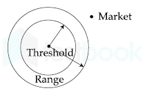
The theory then relied on two concepts: threshold and range.

  • The threshold is the minimum market size (population) needed to support a central place function (service).
  • The range is the maximum distance people are willing to travel to obtain a central place function (service).

There are three fundamental concepts

  • Concept of centrality: it means the importance of the central or focal point which offers goods and services to the complementary area
  • Complementary area: the area served by the central place
  • Concept of hierarchy: the arrangement of the settlement based on their number and size. Generally, there are seven or more levels in a meso-region. In India, there are six levels of settlements.

Hence, the threshold is the minimum number of people needed to support a service.

Question 44

Which one of the following groups of states in Indian recorded Sex Ratio higher than 950 according to year 2011 census ?

  1. AOption (a)

    Andhra Pradesh, Odisha, Telengana

  2. BOption (b)

    Andhra Pradesh, Uttar Pradesh, Maharashtra

  3. COption (c)

    Uttar Pradesh, Punjab, Andhra Pradesh

  4. DOption (d)

    Haryana, Bihar, Andhra Pradesh

View answer & explanation

Correct answer

Answer: (a)A.

Andhra Pradesh, Odisha, Telengana

Why this answer is correct

The male-to-female ratio in a population is known as the sex ratio. The ratio in most sexually reproducing organisms is about 1:1. Fisher's principle explains this trend.

Important Points

According to the 2011 census, *India'*s sex ratio is 943. That is, for every 1000 males, there are 943 females.

  • Andhra Pradesh has the highest sex ratio among the given States which is 993.
  • Odisha has a sex ratio of 979.
  • Telangana was formed out of Andhra Pradesh in **2014.**​

Additional Information

The other combination of states:

  • Andhra Pradesh, Uttar Pradesh, Maharashtra- Only Andhra Pradesh has a sex ratio of more than 950
  • Uttar Pradesh, Punjab, Andhra Pradesh-  Only Andhra Pradesh has a sex ratio of more than 950
  • Haryana, Bihar, Andhra Pradesh- Only Andhra Pradesh has a sex ratio of more than 950

​The table below gives the sex ratio of all the given states:

STATESSEX RATIO
Andhra Pradesh993
Odisha979
Maharashtra929
Bihar918
Uttar Pradesh912
Punjab895
Haryana879

Hence, Andhra Pradesh, Odisha, Telangana recorded Sex Ratio higher than 950 according to the year 2011 census

Question 45

Which one of the following Models is explained by the given figure below :

  1. AOption (a)

    Weber’s Model

  2. BOption (b)

    Central place Model

  3. COption (c)

    Von Thunen Model

  4. DOption (d)

    Gravity Model

View answer & explanation

Correct answer

Answer: (b)B.

Central place Model

Why this answer is correct

The above-given figure explains the Central Place model.

Central Place model:

  • The theory was postulated by Walther Christaller
  • It was published in his book “Central Place in Southern Germany” (Die zentralen Orte in Suddeutschland) in 1933
  • Translated in English in 1966
  • It is a normative theory
  • Based on the data obtained from Bavaria in South Germany
  • No of settlements are represented by ‘K’

Key Points

Basic concepts:

  • Threshold: it is the minimum population requires for the establishment of a service

  • Range: the maximum distance one can travel for a single amenity/good/service

  • There are three fundamental concepts

  • Concept of centrality: it means the importance of the central or focal point which offers goods and services to the complementary area

  • Complementary area: the area served by the central place

  • Concept of hierarchy: the arrangement of the settlement based on their number and size. Generally, there are seven or more levels in a meso-region. In India, there are six levels of settlements.

Important Points

Principles of multiple nuclei theory:

The market principle:

  • Here K=3 ( K=1+(6/3)=3)
  • The market area of higher-order place includes a third of the market area of each of the following size neighboring lower-order places
  • Each marketing place is located at the corner of a hexagon around the higher-order settlement
  • Each high-order settlement gets 1/3 of each lower-order settlement

The transport principle:

  • The market area of higher-order includes half of the market area of the lower order places
  • They located on the edge of the hexagon
  • It results in the most efficient transport network
  • There are maximum central places possible located on the main transport routes connecting the higher-order centers
  • Here K=4 , K= 1+(6/2)=4

The administrative principle:

  • Settlements are nested according to sevens
  • The market areas of the smaller settlements are completely enclosed within the area of the larger settlement
  • Tributary areas must be allocated exclusively to a single higher-order place
  • Efficiency administration is the control principle in this hierarchy
  • Here K=7, K= 1+6

Question 46

Which one of the following code is correctly depicting the pattern of distribution of population among cities by ‘d’ curve in the given graph ?

  1. AOption (a)

    Primate

  2. BOption (b)

    Slepped order

  3. COption (c)

    Binary

  4. DOption (d)

    Rank Size Rule

View answer & explanation

Correct answer

Answer: (c)C.

Binary

Why this answer is correct

Key Points

Rank-size analysis:

  • The Rank Size Rule applies to modern cities but when we try to apply the same law to the older cities we face difficulty in correlating the theory.
  • The geographers try to correlate the data with the population datum which we don’t have in the case of ancient cities an ancient city was characterized by city walls or fortifications but the settlement was never within the city walls, it always exceeded.
  • The population of the city will depend on the city area. A larger city will have a larger population.

Hence, 'd' representing Binary curve in the given graph.

Question 47

Match List - I with List - II and select correct answer from the code given below :

List-I (Settlement Alignment)List-II (Settlement Pattern)
A. 1. Uniform
B. 2. Star Shaped
C. 3. Linear
D. 4. Cluster
  1. AOption (a)

    A - 2, B - 3, C - 4, D - 1

  2. BOption (b)

    A - 3, B - 4, C - 2, D - 1

  3. COption (c)

    A - 1, B - 2, C - 3, D - 4

  4. DOption (d)

    A - 4, B - 3, C - 2, D - 1

View answer & explanation

Correct answer

Answer: (b)B.

A - 3, B - 4, C - 2, D - 1

Why this answer is correct

Key Points

List-I (Settlement Alignment)List-II (Settlement Pattern)
A.3. Linear
B.4. Cluster
C.2. Star Shaped
D.1. Uniform

Hence, the correct matching is A - 3, B - 4, C - 2, D - 1

Question 48

Match the List - I with List - II and select the correct answer from the code given below :

aList-I (Demographic terms)List-II (Explanation)
A. Cohart1. Birth rate minus death rate
B. Natural increase2. A population group unified By a specific common characteristic
C. Total fertility rate3. Average number of children that a women will bear through her child bearing years
D. Dependency ratio4. Measure in terms of number of dependents Against productive age groups
  1. AOption (a)

    A - 3. B - 4, C - 2, D - 1

  2. BOption (b)

    A - 2. B - 1, C - 3, D - 4

  3. COption (c)

    A - 1. B - 4, C - 3, D - 2

  4. DOption (d)

    A - 4. B - 2, C - 1, D - 3

View answer & explanation

Correct answer

Answer: (b)B.

A - 2. B - 1, C - 3, D - 4

Why this answer is correct

Key Points

aList-I (Demographic terms)List-II (Explanation)
A. Cohart2. A population group unified By a specific common characteristic
B. Natural increase1. Birth rate minus death rate
C. Total fertility rate3. Average number of children that a women will bear through her child bearing years
D. Dependency ratio4. Measure in terms of number of dependents Against productive age groups

Hence, the correct matching is A - 2. B - 1, C - 3, D - 4

Question 49

Which one of the following groups of states of India recorded more than one fourth of total population of the country in the census year 2011 ?

  1. AOption (a)

    Uttar Pradesh, Assam, Punjab

  2. BOption (b)

    Uttar Pradesh, Madhya Pradesh, Karnataka

  3. COption (c)

    Uttar Pradesh, Andhra Pradesh, Punjab

  4. DOption (d)

    Uttar Pradesh, Gujarat, Haryana

View answer & explanation

Correct answer

Answer: (b)B.

Uttar Pradesh, Madhya Pradesh, Karnataka

Why this answer is correct

According to the 2011 Census, India's population is 1.21 billion, an increase of more than 181 million in the past ten years. The Indian Census of 2011 was divided into two stages: house listing and housing census and population enumeration.

Important Points

  • The total population of India as per the 2011 census is 1210569573.
  • The table given below has stated and their population given adjacent to them:
STATEPOPULATION
Uttar Pradesh199812341
Assam31205576
Punjab27743338
Madhya Pradesh72626809
Karnataka61095297
Gujarat60439692
Haryana25351462
Andhra Pradesh84580777

Hence, we can say that Uttar Pradesh, Madhya Pradesh, Karnataka recorded more than one-fourth of the total population of the country in the census year 2011.

Question 50

Match the List - I with List - II and select the correct answer from the code given below :

List-I (Economy)List-II (Features)
A. Subsistence Economy1. Market competitions as primary force shaping the production patterns
B. Commercial Economy2. Self sufficiency, low production and low population density
C. Intensive Subsistence Economy3. Self sufficiency high production and high population density
D. Extensive Subsistence Economy4. Little exchange of goods and only limited need for markets
  1. AOption (a)

    A - 2, B - 3, C - 1, D - 4

  2. BOption (b)

    A - 4, B - 1, C - 3, D - 2

  3. COption (c)

    A - 3, B - 2, C - 4, D - 1

  4. DOption (d)

    A - 1, B - 4, C - 3, D - 2

View answer & explanation

Correct answer

Answer: (b)B.

A - 4, B - 1, C - 3, D - 2

Why this answer is correct

List-I (Economy)List-II (Features)
Subsistence Economy- In a subsistence economy, goods are produced to provide for oneself or one's family. - A subsistence economy is an economy directed to basic subsistence (the provision of food, clothing, shelter) rather than to the market - That means, little exchange of goods, only the limited need for markets.
Commercial Economy- The commercial economy is driven by a market (protected thoroughly from fraud) that consistently produces technology and increases personal wealth. - When the cost of the inventory falls, the efficiency of said market increases. - Commercial economics is the study of economic principles and concepts used in decision-making and as such it lies on the border line of economics and business management. - Commercial economics bridges the gap between economics on the one hand and business management on the other.
Intensive Subsistence Economy- The term, ‘intensive subsistence agriculture’ is used to describe a type of agriculture characterized by high output per unit of land and relatively low output per worker. - Self-sufficiency, high production, high density of population are the main characteristic feature.
Extensive Subsistence Economy- Extensive Subsistence Agriculture. an agricultural technique where a vast expanse of land is cultivated to yield minimal output of crops and animals for the primary consumption of the grower's family. - Self-sufficiency, low production, low density of population are the main character.

Question 51

The formula PI=YYn÷TTn\rm PI=\dfrac{Y}{Yn}\div\dfrac{T}{Tn} where PI = Agriculture Productivity Index ; Y= Total production of selected crops in unit Area; Yn= Total production of same selected crops at national level; T=Total cropped area of the unit ; Tn = Total cropped area at national scale. Who applied this formula for measuring agricultural productivity levels ?

  1. AOption (a)

    Bhatia

  2. BOption (b)

    Enyedi

  3. COption (c)

    Weaver

  4. DOption (d)

    Shafi

View answer & explanation

Correct answer

Answer: (b)B.

Enyedi

Why this answer is correct

In 1964, Enyedi devised new techniques for determining an Index of productivity coefficient of agriculture

Key Points

Agriculture Productivity Index by Enyedi:

  • While discussing geographical types of agriculture, Enyedi (1964) devised technique (8) for determining an index of productivity coefficient.
  • Enyedi's formula of productivity index is:
  • Productivity Index, PI=YYn÷TTn\rm PI=\dfrac{Y}{Yn}\div\dfrac{T}{Tn}

Where

  • Y is the total production of the selected crop in unit area,
  • Yn is the total production of the same crop on a national scale,
  • T is the total cropped area of the unit area, and
  • Tn is the total cropped area on a national scale.

Conclusion:

  • Enyedi's technique is appreciable in the sense that it determines the productivity index of an area with reference to the national level.
  • However, the technique does not consider that in certain cases the productivity index is influenced by the magnitude of the area under a particular individual crop.
  • Besides, when the district yield is less than the national yield, its productivity index is higher than the national level.

Question 52

Which one of the following conditions Alfred Weber introduced in his concept of ‘Locational Triangle’ ?

(where : ‘R1’ and ‘R2’ are two raw materials)

  1. AOption (a)

    Both ‘R1’ and ‘R2’ are found universally

  2. BOption (b)

    ‘R1’ is fixed but ‘R2’ is found everywhere and both are pure

  3. COption (c)

    Both ‘R1’ and ‘R2’ are fixed and pure

  4. DOption (d)

    Both ‘R1’ and ‘R2’ are fixed and gross

View answer & explanation

Correct answer

Answer: (d)D.

Both ‘R1’ and ‘R2’ are fixed and gross

Why this answer is correct

The correct answer is Both ‘R1’ and ‘R2’ are fixed and gross.

Important Points

Webers theory of Industrial Location:

  • Weber propounded the theory in 1909
  • It is also called ‘Least Cost Location Theory‘ and was published in his classical work ‘Uber den Stanford der Industrien‘
  • It has probably had more influence on Industrial location theory than any other single contribution
  • The model is a device for analyzing the location of industry, which he elaborated as ‘Locational Triangle’
  • It is an idealistic model of industrial location based on a set of criteria & simplifying assumption
  • It is a normative deductive model (considering man as economic and rational who conclude things based on facts/experiences/logical reasoning) which speaks partial truth and doesn’t claim the universal application of theory.

Key Points

Locational Triangle by Alfred Weber:

In the case of 2 Raw Materials, there are 4 possible locations with a triangular setup –

  1. If RM1 is Pure & Fixed, RM2 is Gross & Fixed & 3 points(RM1, RM2 & market) are equidistant from each other – Industry can be located either at the market or at RM2.
  2. If RM1 is Gross & Ubiquitous, RM2 is Gross & Fixed – Industry will be located at RM2.
  3. If RM1 is Gross & Fixed and RM2 is also Gross & Fixed, the preferred site of the industry is well defined upon relative weight losing of Raw Material. e.g. Iron & steel (2-ton coal & 2-ton iron ore produce 1-ton steel)

Explanation:

  • In this case, Weber considered a complex situation & suggested a centroid location (P) for the industry.
  • Since RM1 & RM2 both are fixed & gross – they exert an equal pull.
  • Based on Distance Minimization Principle, optimum location P will be closer to the RM sources to save transportation costs.
  • The midpoint between RM1 and RM2 is O, which can’t be the optimum location because marketing also exacts its pull & P is the optimum location from where RM1 and RM2 are at the economic distance & also the optimum distance from the market.
  • The least transport cost point P is the point at which the total cost of moving raw materials and finished products is the least.
  • The location of an industry in a triangular area is closely influenced by the nature of raw material and the Material Index of each raw material.

Additional Information

  • Pure Raw Material – If the weight of raw material remains the same even after processing, it is called Pure Raw Material
  • Gross Raw Material – If the weight of raw material is reduced in weight after processing, it is called Gross Raw Material

Question 53

The book ‘Geography of peace’ is authored written by :

  1. AOption (a)

    mahan

  2. BOption (b)

    Spykman

  3. COption (c)

    Haushoffer

  4. DOption (d)

    Ratzel

View answer & explanation

Correct answer

Answer: (b)B.

Spykman

Why this answer is correct

The question of world peace and its restoration became very pertinent in the face of world war I and II. Many literature were authored keeping this in mind. 

Important Points

  • Spykman authored The Geography of Peace published in 1944.
  • The Second World War was still raging in Europe and Asia, and on the oceans of the world.​

Additional Information

  • Mahan- In the late 19th and early 20th centuries, American naval commander and historian who was a powerful proponent of sea power. "The Influence of Sea Power on History, 1660–1783" and "The Influence of Sea Power on the French Revolution and Empire, 1793–1812" are two of his major publications.
  • Haushoffer- Haushofer's geopolitical ideas impacted Adolf Hitler's expansionist plans through his student Rudolf Hess. He created the phrase "Lebensraum" for political usage.
  • Ratzel- subdivided Ritter's human geography into anthropogeography and political geography. He's well known for his organic state hypothesis (lebensraum).

Hence Spykman is the author of 'Geography of peace'.

Question 54

Which of the following catagories does Chile belong to according to its physical shape ?

  1. AOption (a)

    Compact and elongated

  2. BOption (b)

    Elongated

  3. COption (c)

    Fragmented and elongated

  4. DOption (d)

    Fragmented

View answer & explanation

Correct answer

Answer: (c)C.

Fragmented and elongated

Why this answer is correct

Shape analysis:

  • The most common object measurements made are those that describe the shape.
  • Shape measurements are physical dimensional measures that characterize the appearance of an object.
  • The goal is to use the fewest necessary measures to characterize an object adequately so that it may be unambiguously classified.

Key PointsThe shape of Chile:

  • Chile belong to elongated category according to its physical shape
  • In its simplest form elongation is the ratio between the length and width of the object bounding box:
  • Elongation = Width / length
  • The result is a measure of object elongation, given as a value between 0 and 1.
  • If the ratio is equal to 1, the object is roughly square or circularly shaped.
  • As the ratio decreases from 1, the object becomes more elongated.
  • This criterion cannot succeed in curved regions, for which the evaluation of elongatedness must be based on maximum region thickness.
  • Elongatedness can be evaluated as a ratio of the region area and the square of its thickness.
  • The maximum region thickness (holes must be filled if present) can be determined as the number d of erosion steps that may be applied before the region totally disappears

Hence, Fragmented and elongated is the correct answer.

Question 55

Whose works epitomized the relationship or political geography with foreign policy ?

  1. AOption (a)

    Adolf Hitler

  2. BOption (b)

    Friedrich Ratzel

  3. COption (c)

    Mackinder

  4. DOption (d)

    Karl Haushofer

View answer & explanation

Correct answer

Answer: (d)D.

Karl Haushofer

Why this answer is correct

Karl Haushofer works epitomized the relationship or political geography with foreign policy

Important Points

  • Haushofer's geopolitical ideas impacted Adolf Hitler's expansionist plans through his student Rudolf Hess.
  • He created the phrase "Lebensraum" for political usage.
  • Haushofer developed Geopolitik from widely varied sources, including the writings of Oswald Spengler, Alexander Humboldt, Karl Ritter, Friedrich Ratzel, Rudolf Kjellén, and Halford J. Mackinder.
  • Geopolitik contributed to Nazi foreign policy chiefly in the strategy and justifications for lebensraum.
  • The theories contributed five ideas to German foreign policy in the interwar period:
  • organic state
  • lebensraum
  • autarky
  • pan-regions
  • land power/sea power dichotomy.
  • Geostrategy as political science is both descriptive and analytical like political geography but adds a normative element in its strategic prescriptions for national policy.

Additional Information

  • Adolf Hitler- was a German Fascist ruler who is known in history for his Nazi ideology, totalitarian state, his measures against the Jewish community, and his role in starting the second world war. His intellectual leader was Haushofer and Hess. He employed their ideas of Lebensraum and carried out territorial expansion.
  • Friedrich Ratzel- The Organic State Theory was theorized in 1897 by Friedrich Ratzel, a nineteenth-century German geographer and ethnographer. He thought the state was organic because he thought political bodies, such as countries, behaved similarly to living beings.
  • Mackinder- labeled continental Europe as 'World Island' and asserted that having control over them meant having political power over the world.

​Hence, Haushofer epitomized the relationship between political geography with foreign policy.

Question 56

Which one of the following code is correct showing number of vertices, edges and Diameter for the given network ?

<br>


VerticesEdgesDiameter
A.1075
B.10107
C.1056
D.1087
  1. AOption (a)

    A

  2. BOption (b)

    B

  3. COption (c)

    C

  4. DOption (d)

    D

View answer & explanation

Correct answer

Answer: (b)B.

B

Why this answer is correct

Important Points

Network topology:

  • Graphs have some properties that are very useful when unraveling the information that they contain.
  • It is important to realize that the purpose of any type of network analysis is to work with the complexity of the network to extract meaningful information that you would not have if the individual components were examined separately.
  • Network properties, and particularly topological properties, can help us identify relevant sub-structures within a network.
  • Topology is the way in which the nodes and edges are arranged within a network.
  • Topological properties can apply to the network as a whole or to individual nodes and edges.

Key Points

  1. Nodes: The nodes represent different entities (e.g. proteins or genes in biological networks)
  2. Edges: The edges convey information about the links between the nodes.
  3. Diameters: The diameter of a graph is the maximum eccentricity of any vertex in the graph. That is, it is the greatest distance between any pair of vertices. The diameter of a network is defined as the longest path of the shortest path between any two nodes. For example, the diameter of a 4x4 mesh D = 6

In the above image, the number of vertices is 10, no of edges is 10 and the diameter is 7.

Question 57

Which one of the following factors most dominants in the localisation of high-tech firms of silicon valley in California ?

  1. AOption (a)

    Cheap Labour

  2. BOption (b)

    Access to the market

  3. COption (c)

    High speed transportation

  4. DOption (d)

    Agglomeration economy

View answer & explanation

Correct answer

Answer: (d)D.

Agglomeration economy

Why this answer is correct

  • Agglomeration economies are the benefits that come when firms and people locate near one another together in cities and industrial clusters.
  • These benefits all ultimately come from transport costs savings: the only real difference between a nearby firm and one across the continent is that it is easier to connect with a neighbor. Of course, transportation costs must be interpreted broadly, and they include the difficulties in exchanging goods, people, and ideas. The connection between agglomeration economies and transport costs would seem to suggest that agglomerations should become less important, as transportation and communication costs have fallen. Yet, a central paradox of our time is that in cities, industrial agglomerations remain remarkably vital, despite ever easier movement of goods and knowledge across space
  • In particular, the agglomeration economy case for policies like Crossrail that enhance larger cities often rests on the existence of nonlinearities, such that agglomeration economies get stronger as cities grow. Despite the century or so of research on agglomeration economies, we are still far from having reliable estimates of such nonlinearities.
  • Understanding agglomeration economies requires us to move beyond measuring the overall extent of agglomeration as revealed by housing prices, productivity, and population concentration. We must also understand the exact mechanisms that make it more productive to cluster. While all agglomeration economies can be understood as consequences of reduced transport costs, the nature of the agglomeration economy will depend on what transport costs are being reduced.
  • For example, the classic Krugman (1991) model of agglomeration emphasized agglomeration benefits that come from reducing the costs of moving goods over space. When an input supplier locates next to a final goods producer, these fi rms become more productive by saving the costs of shipping the input.

Question 58

Match the List - I with List - II and select the correct answer from the code given below :

List-I (Countries)List-II (Mineral Reserves)
A. Liberia1. Iron
B. Guinea2. Uranium
C. Togo3. Phosphate
D. Niger4. Bauxite
  1. AOption (a)

    A - 4, B - 3, C - 2, D - 1

  2. BOption (b)

    A - 1, B - 4, C - 3, D - 2

  3. COption (c)

    A - 2, B - 1, C - 4, D - 3

  4. DOption (d)

    A - 3, B - 2, C - 1, D - 4

View answer & explanation

Correct answer

Answer: (b)B.

A - 1, B - 4, C - 3, D - 2

Why this answer is correct

Key Points 

CountriesMineral Reserves
A. Liberia1. Iron
B. Guinea4. Bauxite
C. Togo3. Phosphate
D. Niger2. Uranium

Hence, the correct matching is ​A - 1, B - 4, C - 3, D - 2

Important Points

CountriesMines
A. Liberia- Liberia is a leading country in mineral resources with substantial iron ore, gold, and diamond deposits. - Iron ore mining was previously undertaken by American and European companies in the areas of Bomi Hills, Bong Mines, Mano River, and Nimba.
B. Guinea- Guinea's bauxite reserve is 7.4 billion metric tons, which is 26.4 percent of global reserves. - High-grade iron ore reserves account for more than 4 billion tonnes.
C. Togo- The mining industry of Togo is centered mainly around the extraction of phosphate, ranking it 19th in world production. - Togo has an estimated 60 million metric tons of phosphates reserves
D. Niger- Niger is a country struck by poverty, and the fact that nuclear energy is available for the country to extract is a blessing. - However, uranium extraction to be used for nuclear energy is taken advantage of by foreign powers.

Question 59

Match the List - I with List - II and select the correct answer from the code given below :

List-I (Sector of the Economy)List-II (Activities)
A. Primary1. Research endavours
B. Secondary2. Train service
C. Tetirary3. Pearl culture
D. Quaternary4. Spinning cotton year
  1. AOption (a)

    A - 1, B - 2, C - 3, D - 4

  2. BOption (b)

    A - 3, B - 4, C - 2, D - 1

  3. COption (c)

    A - 2, B - 1, C - 4, D - 3

  4. DOption (d)

    A - 4, B - 3, C - 1, D - 2

View answer & explanation

Correct answer

Answer: (b)B.

A - 3, B - 4, C - 2, D - 1

Why this answer is correct

Key Points 

Sector of the EconomyActivities
A. Primary3. Pearl culture
B. Secondary4. Spinning cotton year
C. Tetirary2. Train service
D. Quaternary1. Research endeavors

Hence, the correct matching is A - 3, B - 4, C - 2, D - 1

Important PointsActivities that generate income are termed economic activities. On the basis of economic activities, the Indian economy can be divided into 3 major sectors that are the primary sector, the secondary sector, and the tertiary sector. There are two other sectors also, called quaternary and quinary activity.

Sector of EconomyNature of activityExamples
PrimaryExtraction of raw materialsDairy, Hunting and gathering, pastoral activities, fishing, forestry, agriculture, and mining and quarrying.
SecondaryManufacturingManufacturing processing and construction (infrastructure) industries.
TertiaryServicesTrade and commerce, retail trading services, communication services
QuaternaryKnowledge orientedQuaternary activities are specialized tertiary activities in the ‘Knowledge Sector’ which demand a separate classification.

Question 60

Which one of the following statements indicates to the potential use of a service at a location according to Gravity Model ?

  1. AOption (a)

    Direct relationship to both population size and distance

  2. BOption (b)

    Inverse relationship to both population size and distance

  3. COption (c)

    Direct relationship to population size and inverse relationship to distance

  4. DOption (d)

    Direct relationship to distance and inverse relationship to population

View answer & explanation

Correct answer

Answer: (c)C.

Direct relationship to population size and inverse relationship to distance

Why this answer is correct

Key Points

Gravity model:

  • In economics, Reilly's law of retail gravitation is a heuristic developed by William J. Reilly in 1931.
  • According to Reilly's "law," customers are willing to travel long distances to larger retail centers given the higher attraction they present to customers.
  • In Reilly's formulation, the attractiveness of the retail center becomes the analogy for size (mass) in the physical law of gravity.
  • The law presumes the geography of the area is flat without any rivers, roads, or mountains to alter a consumer's decision of where to travel to buy goods.
  • It also assumes consumers are otherwise indifferent between the actual cities.
  • In analogy with Newton's law of gravitation, the point of indifference is the point at which the "attractiveness" of the two retail centers (postulated to be proportional to their size and inversely proportional to the square of the distance to them) is equal: da/db = Pa/Pb
  • The breaking point (BP) boundary making the outer edge of their respective trade areas according to Reillys Law of Retail Gravitation
  • The formula of breaking point, d= D/(1+√(Pa/Pb))
  • Where,
  • D= distance between two cities
  • Pa= population of the largest city
  • Pb= population of a smaller city

Hence, the direct relationship to population size and inverse relationship to distance at a location according to Gravity Model.

Additional InformationSome other models based on Gravity Model

  • Gravity Model is Further Developed in different calculation of Potentials like as:
  • Working Population Model: Mab= WPa WPb/(dab)2
  • Goods Shop Model: Mab= SaSb/(dab)2 Where S = Shops
  • Population Density Model: Mab= PDaPDb/(dab)2
  • Per Capita Income Model: Mab= PCIaPCIb/(dab)2
  • Travels Mean Model: Mab= MTaMTb/(dab)2
  • Communication line Model: Mab= MCaSMC/(dab)2

Question 61

Match List - I with List - II and select the correct answer using the code given below :

List-I (Whiltlesey’s Agriculture Religions)List-II (Name of Countries)
A. Commercial Dairy Farming1. Argentina
B. Commercial Grain Farming2. Sri Lanka
C. Nomadic Herding3. New Zealand
D. Commercial Plantations4. Mongolia
  1. AOption (a)

    A - 3, B - 1, C - 4, D - 2

  2. BOption (b)

    A - 1, B - 2, C - 3, D - 4

  3. COption (c)

    A - 4, B - 3, C - 2, D - 1

  4. DOption (d)

    A - 2, B - 4, C - 1, D - 3

View answer & explanation

Correct answer

Answer: (a)A.

A - 3, B - 1, C - 4, D - 2

Why this answer is correct

Key Points 

Whiltlesey’s Agriculture ReligionsName of Countries
A. Commercial Dairy Farming3. New Zealand
B. Commercial Grain Farming1. Argentina
C. Nomadic Herding4. Mongolia
D. Commercial Plantations2. Sri Lanka

Hence, the correct matching is A - 3, B - 1, C - 4, D - 2

Important Points

Whiltlesey’s Agriculture ReligionsCharacteristics
A. Commercial Dairy Farming- New Zealand – in a nutshell, it is one of the most profitable dairy farming sectors and the lowest-cost producers globally. - Dairy farming is a big business in New Zealand and it is New Zealand's top export earner.
B. Commercial Grain Farming- The major countries where commercial grain farming has successfully developed are U.S.A. and Canada in N. America; Argentina in S. America; Australia and New Zealand in Oceania and Ukraine, Russia, Germany, France, Netherlands, etc. in Europe.
C. Nomadic Herding- Nomadic herders live in Mongolia, tending herds of sheep, goats, camels, yaks, and horses just as their ancestors have for more than 3,000 years. - Herder families live in canvas wool tents called a ger. - To erect a ger, a canvas covering is draped over a frame of wooden supports, like the spokes of a bicycle wheel.
D. Commercial Plantations- Sri Lanka's primary food crop is rice. - Rice is cultivated during two seasons. - Tea is cultivated in the central highlands and is a major source of foreign exchange. - Fruit, vegetables, and oilseed crops are also cultivated in the country.

Question 62

The Organic Theory of state was propounded by :

  1. AOption (a)

    Ratzel

  2. BOption (b)

    mackinder

  3. COption (c)

    Isaiah Bowman

  4. DOption (d)

    Haushoffer

View answer & explanation

Correct answer

Answer: (a)A.

Ratzel

Why this answer is correct

Ratzel further subdivided Ritter's human geography into anthropogeography and political geography. He's well known for his organic state hypothesis (lebensraum).

Important Points

  • It was theorized in 1897 by Friedrich Ratzel, a nineteenth-century German geographer and ethnographer.
  • He thought the state was organic because he thought political bodies, such as countries, behaved similarly to living beings.

Additional Information

  • Mackinder- labelled continental Europe as 'World Island' and asserted that having control over them meant having political power over the world.
  • Isaiah Bowman- is an American Geographer who is popular for his authored book 'New World', a book on political geography.
  • Haushoffer- Haushofer's geopolitical ideas impacted **Adolf Hitler'**s expansionist plans through his student Rudolf Hess. He created the phrase "Lebensraum" for political usage.

​Hence, Ratzel propounded the Organic State Theory.

Question 63

The Rimmer model for the development of land transport system in less developed economics was proposed in which of the following years ?

  1. AOption (a)

    1975

  2. BOption (b)

    1976

  3. COption (c)

    1977

  4. DOption (d)

    1978

View answer & explanation

Correct answer

Answer: (c)C.

1977

Why this answer is correct

The correct answer is 1977

Important Points

  • Transport network models comprise of frameworks for the transportation infrastructure, and their development is based on a number of intrinsic contributory factors of which environmental features are a critical part. Transport network models are thus used as frameworks to formulate systems.
  • The development of transport networks utilizes several models for understanding the mode of development of the system. Such models can be quite specific regarding the mode of development of the transport networks they study. Some models lay a priority on spatial dimensions, some on modes of transport, while other approaches lay emphasis on a factor, such as analyzing the economic aspects of transport networks in their development. Among Transport Development Models, some notable models are as follows –

Key Points

  • Rimmer in 1977 presented a four phase model for the analysis of interrelated development of transport networks between developed countries and third world nations.  The model traces the impact of colonialism on the development of transport systems in these nations.
  • The first phase begins with no links between the two, with more badly made roads, a limited amount of tracks for trains, etc with a socio-economic order with restricted means and ends.
  • The early colonial phase is the second phase, and consists of exploration of the regions by colonial powers through sea routes, beginning with seafaring trade and limited settlements on these nations by colonial powers.
  • The third phase occurs post colonization, and here the colonial powers engage in laying their basic infrastructure such as roads and railways along with radical changes in the political and economic organization of Third World nations.

The last phase in this model is the neo-colonial stage, involving diversification and modernization of the transport systems. These transport networks were aimed at resource extraction from colonized nations by the colonial powers.

Question 64

Match the List - I with List-II and select the correct answer from the code given below :

List-I (Country)List-II (Official Language)
A. Luxembourg1. Arabic
B. Algeria2. Russian
C. Chile3. French
D. Kazakistan4. Spanish
  1. AOption (a)

    A - 1, B - 3, C - 2, D - 4

  2. BOption (b)

    A - 2, B - 4, C - 3, D - 1

  3. COption (c)

    A - 3, B - 1, C - 4, D - 2

  4. DOption (d)

    A - 4, B - 2, C - 1, D - 3

View answer & explanation

Correct answer

Answer: (c)C.

A - 3, B - 1, C - 4, D - 2

Why this answer is correct

Key Points 

CountryOfficial Language
A. Luxembourg3. French
B. Algeria1. Arabic
C. Chile4. Spanish
D. Kazakistan2. Russian

Hence, the correct matching is A - 3, B - 1, C - 4, D - 2

Important PointsOfficial language:

  • An official language is a language given a special status in a particular country, state, or other jurisdiction.
  • Typically the term "official language" does not refer to the language used by a people or country, but by its government (e.g. judiciary, legislature, and/or administration).
  • 178 countries recognize an official language, 101 of them recognizing more than one.
  • Many of the world's constitutions mention one or more official or national languages.

Question 65

Among the following scholars, who introduced the concept of ‘least-transport-cost location’ using the frame of ‘locational triangle’.

  1. AOption (a)

    W. Isard

  2. BOption (b)

    M. K. Bandman

  3. COption (c)

    D. M. Smith

  4. DOption (d)

    A. Weber

View answer & explanation

Correct answer

Answer: (d)D.

A. Weber

Why this answer is correct

The purpose of Weber's least cost theory is to look at the costs of each item in the processing chain, from acquiring raw materials to putting a completed product on a shop shelf.

Important Points

  • This hypothesis is based on the 'least-cost principle,' which is used to determine where a manufacturing industry should be located.
  • The idea is founded on the assumption of a single, isolated nation with uniform conditions.
  • Some of the natural resources in this environment may be found anywhere, while others are restricted to certain areas.
  • The labor is stationed in a certain area.
  • In this case, transportation expenses are determined by cargo weight and distance.
  • Demand for all items is the same across the board, the price for all products is consistent across all locations.
  • The location P with the lowest transport cost is where the overall cost of conveying raw materials and finished goods is the lowest.
  • The type of raw materials and the Material Index of each raw material has a significant impact on the placement of an industry in a triangle region.​

Additional Information

  • W.Isard- is a well-known American economist who is credited with founding the field of regional science as well as one of the disciplines of peace studies and peace economics.
  • M.K. Bandman- was an economic geographer from the Soviet school of geography and was responsible for the theory of rationalisation.
  • D.M. Smith- introduced the Welfare element in his approach to human geography.

Hence, A. Weber introduced the concept of ‘least-transport-cost location’ using the frame of ‘locational triangle’.

Question 66

In which one of the following book/works did Mackinder in 1919 renamed his theory of ‘pivot area’ as ‘Heartland’ ?

  1. AOption (a)

    World War and Geography

  2. BOption (b)

    The Democratic ideals and Reality

  3. COption (c)

    The Round world and The winning of the peace

  4. DOption (d)

    Foreign Affairs

View answer & explanation

Correct answer

Answer: (b)B.

The Democratic ideals and Reality

Why this answer is correct

The following is what Mackinder proposed, which became known as the Heartland Theory: He referred to the "heartland" as the "pivot area" and the "centre of Eurasia," and he referred to Europe and Asia as the "World Island." Controlling the 'World Island' results in 'World Domination.'

Important Points

  • Democratic Ideals and Reality, published early in 1919 while the Paris Peace Conference was in session.
  • Mackinder postulated the following, which became known as the Heartland Theory:
  • Who rules Eastern Europe commands the Heartland
  • Who rules the Heartland commands the World Island
  • Who rules the World Island commands the world

Additional Information

  • Germany and Russia were fighting for control of the Heartland when Mackinder penned "The Round World and the Winning of the Peace." He opened this post by stating that the Heartland was inspired by two events: the South African Boer War and the Russo-Japanese War.
  • Alison Lurie authored Foreign Affairs.

​Hence, The Democratic ideals and Reality is the book in which Mackinder in 1919 renamed theory 'pivot area' as 'Heartland'.

Question 67

Match the List - I with List - II and select the correct answer from the code given below :

List-I (Name of Books)List-II (Name of Authors)
A. Human Universal1. W. H. Durham
B. The Social Conquest of the Earth2. Donald E. Brown
C. Not By Gene Alone3. Edward O-Wilson
D. Coevolution4. Peter J. Richerson
  1. AOption (a)

    A - 1, B - 2, C - 3, D - 4

  2. BOption (b)

    A - 4, B - 1, C - 2, D - 3

  3. COption (c)

    A - 2, B - 3, C - 4, D - 1

  4. DOption (d)

    A - 3, B - 4, C - 1, D - 2

View answer & explanation

Correct answer

Answer: (c)C.

A - 2, B - 3, C - 4, D - 1

Why this answer is correct

Key Points 

Name of BooksName of Authors
A. Human Universal2. Donald E. Brown
B. The Social Conquest of the Earth3. Edward O-Wilson
C. Not By Gene Alone4. Peter J. Richerson
D. Coevolution1. W. H. Durham

Hence, the correct matching is A - 2, B - 3, C - 4, D - 1

Important Points

Name of BooksName of Authors
A. Human Universal- Human Universals is a book by Donald Brown, an American professor of anthropology (emeritus) who worked at the University of California, Santa Barbara. - It was published by McGraw Hill in 1991. - Brown says human universals, "comprise those features of culture, society, language, behavior, and psyche for which there is no known exception."
B. The Social Conquest of the Earth- The Social Conquest of Earth is a 2012 book by biologist Edward O. Wilson. - Wilson adapted the title of Paul Gauguin's famous mural as a theme -- "What are we?", "Where did we come from?", "Where are we going?"—for discussing his topic of eusocial behavior in several arthropod taxa and a few mammalian species, and its role in making humans as a species unique.
C. Not By Gene Alone- The book Not By Genes Alone: How Culture Transformed Human Evolution, Peter J. Richerson and Robert Boyd is published by the University of Chicago Press - In this book, Peter J. Richerson and Robert Boyd argue that only a Darwinian theory of cultural evolution can explain these unique characteristics.
D. Coevolution- This is a book by W. H. Durham - In "Coevolution," the author proposes a powerful new theory of cultural evolution--that is, of the descent with modification of the shared conceptual systems we call "cultures"--that is parallel in many ways to Darwin's theory of organic evolution.

Question 68

In India, how many are the officially recognised languages ?

  1. AOption (a)

    20

  2. BOption (b)

    21

  3. COption (c)

    22

  4. DOption (d)

    23

View answer & explanation

Correct answer

Answer: (c)C.

22

Why this answer is correct

The correct answer is 22.

Key Points

  • The Eighth Schedule to the Constitution of India lists the official languages of the Republic of India.
  • As per Articles 344 (1) and 351 of the Indian Constitution, the eighth schedule includes the recognition of the 22 languages.
  • The language in this schedule includes Assamese, Bengali, Bodo, Dogri, Gujarati, Hindi, Kannada, Konkani, Maithili, Malayalam, Manipuri, Marathi, Nepali, Oriya, Punjabi, Sanskrit, Santhali, Sindhi, Tamil, Telugu, and Urdu.
  • Of these languages, 14 were initially included in the Constitution.
  • Subsequently, Sindhi was added in 1967 by the 21st constitutional amendment act; Konkani, Manipuri, and Manipuri were added in 1992 by the 71st constitutional amendment act; and Bodo, Dogri, Maithili, and Santali were added in 2003 by the 92nd constitutional amendment act.
  • According to Article 343: Hindi in Devanagri Lipi shall be the official language of the Union.

Question 69

Match the List - I with List - II and select the correct answer from the code given below :

List-I (Religious Community)List-II (Population Share (%), 2011)
A. Christian1. 1.7
B. Buddhist2. 0.4
C. sikhs3. 2.3
D. Jains4. 0.7
  1. AOption (a)

    A - 1, B - 2, C - 3, D - 4

  2. BOption (b)

    A - 4, B - 3, C - 2, D - 1

  3. COption (c)

    A - 3, B - 4, C - 1, D - 2

  4. DOption (d)

    A - 2, B - 1, C - 4, D - 3

View answer & explanation

Correct answer

Answer: (c)C.

A - 3, B - 4, C - 1, D - 2

Why this answer is correct

Key Points 

Religious CommunityPopulation Share (%), 2011
A. Christian3. 2.3
B. Buddhist4. 0.7
C. sikhs1. 1.7
D. Jains2. 0.4

Hence, the correct matching is A - 3, B - 4, C - 1, D - 2

 Additional Information

ReligionPopulation%
Hindus966,257,35379.8%
Muslims172,245,15814.2%
Christians27,819,5882.3%
Sikhs20,833,1161.72%
Buddhists8,442,9720.7%
Jains4,451,7530.37%
Other religions7,937,7340.67%
Not stated2,867,3030.24%
Total1,210,854,977100%

Question 70

Which of the following characteristic features are possessed by the nordic race of India ?

  1. AOption (a)

    Long stature and round face

  2. BOption (b)

    Medium stature and round face

  3. COption (c)

    Medium stature and long face

  4. DOption (d)

    Long stature and long face

View answer & explanation

Correct answer

Answer: (d)D.

Long stature and long face

Why this answer is correct

Dr. B. S. Guha’s racial classification is based on anthropometric measurements, which were collected during his investigations from 1930 to 1933. Guha traced six major racial strains and nine sub-types among the modem Indian population. The Nordics are one of them.

Key Points

The nordic race of India:

  • The people are characterized by long head, protruding occiput and arched forehead.
  • The nose is straight and high bridged.
  • All are tall statured with a strong jaws and robust body built.
  • The eye color is blue or grey.
  • The body color is fair which is reddish-white.
  • This element is scattered in different parts of Northern India, especially in the Punjab and Rajputana.
  • The Kho of Chitral, the Red Kaffirs, and the Khatash are some other representatives of this type.
  • The Nordics came from the north, probably from Southeast Russia and Southwest Siberia thereafter penetrated into India through Central Asia.

Hence, a major characteristics feature of the Nordic race in India is Long stature and long face

Question 71

Which one of the following statements is not correct about the selection indicators for conducting any study of development process ?

  1. AOption (a)

    Either input or output indicators must be selected

  2. BOption (b)

    Negative and positive indicators must not be clubbed with each other.

  3. COption (c)

    Indicators must emerge out of the concept of development defined in the study.

  4. DOption (d)

    Indicators of income and expenditure can be clubbed together.

View answer & explanation

Correct answer

Answer: (d)D.

Indicators of income and expenditure can be clubbed together.

Why this answer is correct

Key PointsDeveloopment and its indicators:

  • To know the level of economic development of a country there are different indicators that are used.
  • These indicators help in understanding the level of development, comparisons with other countries, or different time periods.
  • These indicators help in better planning towards achieving economic development.
  • The indicators of economic development are:

1. Growth rate of National Income:

  • In this indicator real income is calculated on constant prices
  • If there is a rise in national income, this indicates economic development.
  • When there is a high rate of national income, the development rate is high and vice versa.

2. Per Capita Income (PCI):

  • The average income of the people living in the country is the per capita income.
  • A rise in PCI is an important indicator of economic development
  • The rise in PCI indicates the economic welfare of the country

3. Per Capita Consumption (PCC):

  • The increase in consumption of goods and services by the people is measured in PCC.
  • Example clothing, food, education, health, etc
  • An increase in PCC shows the better quality of life of people and higher economic development of the country.

4. Physical Quality Life Index (PQLI) and Human Development Index (HDI):

  • PQLI is the overall welfare of the people in life expectancy, infant mortality rate, the standard of living.
  • HDI measures life expectancy, education, and standard of living.
  • A rise in PQLI and HDI shows an improvement in the quality of life of people and therefore economic development.

5. Industrial progress:

  • Industrial progress is an important indicator of the economic development of a country.
  • It helps to increase per capita income and the national output of the country.

6. Capital formation:

  • It means investing in transport, irrigation, roads, electricity, technology, etc. higher capital formation will lead to higher economic development.
  • The indicators under economic development are more towards the qualitative improvement of people in the country.
  • A higher rate of these indicators shows a higher level of economic development.

The indicators of income and expenditure can not be clubbed together. So, it is incorrect about development.

Question 72

Given below are the two statements, one labelled as Assertion (A) and the other labelled as Reason (R). Select your answer from the code given below :

Assertion (A) : The partition of India in 1947 provided an impetus for town planning activities in the country.

Reason (R) : Resettlement of displaced persons and providing them employment opportunities created a big opportunity before the town planners to construct new town and make provision of amenities and facilities in existing towns especially in north Indian states.

  1. AOption (a)

    Both (A) and (R) are true and (R) is the correct explanation of (A).

  2. BOption (b)

    Both (A) and (R) are true but (R) is not the correct explanation of (A).

  3. COption (c)

    (A) is true but (R) is false.

  4. DOption (d)

    (A) is false but (R) is true.

View answer & explanation

Correct answer

Answer: (a)A.

Both (A) and (R) are true and (R) is the correct explanation of (A).

Why this answer is correct

Key Points

Assertion (A): The partition of India in 1947 provided an impetus for town planning activities in the country.

  • The working committee of the Congress Party passed a comprehensive resolution on the planned economy for the country and the appointment of the Planning Commission.
  • The resolution states “ The need for a comprehensive plan has become a matter of compelling urgency in India now owing to the ravages of Second World War and the economic and political consequences of the partition of the country which followed in the wake of achievement of freedom and steady worsening of the economic situation in India and the World. ”
  • Thus the National Planning Commission was established on 15th March 1950.
  • The Planning Commission was set up by a Resolution of the Government of India in March 1950.

Hence, the assertion is correct.

Reason (R): Resettlement of displaced persons and providing them employment opportunities created a big opportunity before the town planners to construct new towns and make provision of amenities and facilities in existing towns especially in north Indian states.

  • In India, the urban population living amid pre-independence years was 13.9 percent in 1941, which rose to 17.3 percent in 1951.
  • Before freedom, about 15 percent of individuals were living in towns and now their number had turned out to be simply doubled.
  • The purposes behind an expansion in the urban population are many, yet the primary reason has been a nonstop stream of the provincial populace to urban zones.
  • Urban advancement accomplishments were wanted through arranging and in this way, autonomous India set out on a national program of general improvement.
  • In this undertaking, ‘making Plans for urban advancement’ involved a prime place.

Hence, the reason is also true and correctly explaining the assertion.

Question 73

Which one of the following criteria was used to demarcate 15 agro-climatic regions, which were accepted by the Planning Commission of India (now NITI Aayog) to initiate regional approach to agricultural planning during the Eighth Five-Year Plan ?

  1. AOption (a)

    Climate, soil characteristics, and rainfall

  2. BOption (b)

    Climate, soil characteristics, and water availability

  3. COption (c)

    Climate, soil characteristics, rainfall and water availability

  4. DOption (d)

    Climate, cropping pattern, rainfall and water availability

View answer & explanation

Correct answer

Answer: (c)C.

Climate, soil characteristics, rainfall and water availability

Why this answer is correct

Key Points

Demarcation of agro-climatic regions in India:

  • In 1988 the Planning Commission came up with a growth strategy based on a holistic approach of area planning for long-term resource efficiency and sustainability.
  • The motivation behind this was that resource-based planning became feasible once homogeneous regions with respect to natural resource endowments (agro-climatic factors) were delineated and their utilization of available natural resource endowments was related to requirements of output and employment.
  • During the late nineteen eighties, a consensus seemed to have been achieved on the primacy of topography for a regional division of India.
  • Based on this notion the Planning Commission delineated 15 agro-climatic zones; there still existed wide variation in a geographical area, population density, soil types, and crops grown.
  • To increase the degree of homogeneity in agro-climatic factors, these 15 zones were further sub-divided into 73 subzones based on more specific soil types, topography, climate, and cropping pattern characteristics.
  • In order to plan agricultural activities more accurately each region into sub-regions based on soil, climate (temperature), rainfall, and other agrometeorological characteristics.
  • Planning Commission has demarcated the geographical area of India into 15 agro-climatic regions.
  • These are further divided into more homogeneous 72 sub-zones.

Hence, Climate, soil characteristics, rainfall, and water availability were the criteria of demarcation of Agro-climatic regions.

Additional InformationThe 15 agro-climatic zones are:-

  1. Zone 1- Western Himalayan Region: Jammu and Kashmir, Uttar Pradesh
  2. Zone 2 - Eastern Himalayan Region: Assam, Sikkim, West Bengal, and all North-Eastern states
  3. Zone 3 - Lower Gangetic Plains Region: West Bengal
  4. Zone 4 - Middle Gangetic Plains Region: Uttar Pradesh, Bihar
  5. Zone 5 - Upper Gangetic Plains Region: Uttar Pradesh
  6. Zone 6 - Trans-Gangetic Plains Region: Punjab, Haryana, Delhi, and Rajasthan
  7. Zone 7 - Eastern Plateau and Hills Region: Maharastra, Uttar Pradesh, Orissa, and West Bengal
  8. Zone 8 - Central Plateau and Hills Region: MP, Rajasthan, Uttar Pradesh
  9. Zone 9 - Western Plateau and Hills Region: Maharastra, Madhya Pradesh, and Rajasthan
  10. Zone 10 - Southern Plateau and Hills Region: Andhra Pradesh, Karnataka, Tamil Nadu
  11. Zone 11 - East Coast Plains and Hills Region: Orissa, Andhra Pradesh, Tamil Nadu, and Pondicherry
  12. Zone 12 - West Coast Plains and Ghat Region: Tamil Nadu, Kerala, Goa, Karnataka, Maharashtra
  13. Zone 13 - Gujarat Plains and Hills Region: Gujarat
  14. Zone 14 - Western Dry Region: Rajasthan
  15. Zone 15 - The Islands Region: Andaman and Nicobar, Lakshadweep.

Question 74

Match the List - I with List-II and select the correct answer from the code given below :

List-I (Name of city)List-II (Period of being planned)
A. Kanchipuram1. Post-Independence
B. Jaisalmer2. Colonial
C. Kodaikanal3. Medieval
D. Bhilai4. Ancient
  1. AOption (a)

    A - 1, B - 2, C - 3, D - 4

  2. BOption (b)

    A - 2, B - 3, C - 4, D - 1

  3. COption (c)

    A - 3, B - 4, C - 1, D - 2

  4. DOption (d)

    A - 4, B - 3, C - 2, D - 1

View answer & explanation

Correct answer

Answer: (d)D.

A - 4, B - 3, C - 2, D - 1

Why this answer is correct

Key Points

Name of cityPeriod of being planned
A. Kanchipuram4. Ancient
B. Jaisalmer3. Medieval
C. Kodaikanal2. Colonial
D. Bhilai1. Post-Independence

Hence, the correct matching is A - 4, B - 3, C - 2, D - 1

Important Points

Name of the cityYear of establishment
Kanchipuram- Kanchipuram was once the capital of the Pallava dynasty. - It is considered one of the seven sacred cities of India - Established between the 6th and 7th centuries
Jaisalmer- Jaisalmer is named after Rawal Jaisal, a Bhati ruler who found the city in 1156 AD. - Jaisalmer means the Hill Fort of Jaisal. - Jaisalmer is sometimes called the "Golden City of India" because the yellow sandstone used throughout the architecture of both the fort and the town below, imbues both with a certain golden-yellow light.
Kodaikanal- Modern Kodaikanal was established by American Christian missionaries and British bureaucrats in 1845, as a refuge from the high temperatures and tropical diseases of the plains. - In the 20th century, a few elite Indians came to realize the value of this enchanting hill station and started relocating here.
Bhilai- Bhilai was a small village and a part of the Haihaiyavansi Kingdom until 1740 when it was conquered by the Marathas. - The foundation of the modern city of Bhilai was laid in 1955 when the Indian government signed a historic agreement with the Soviet Union in Magnitogorsk to establish a steel plant near the village. - The first blast furnace of the plant was commissioned in 1959 by the first president of India, Dr. Rajendra Prasad.

Question 75

Match the List - I with List - II and select the correct answer from the code given below :

List-I (Name of scholars developed Scheme for delineation of Planing Regions)List-II (Number of Meso regions)
A. Bhat and Prakasarao1. 42
B. P. Sengupta2. 35
C.C. S. Chandrasekhar3. 48
D. V. Nath4. 51
  1. AOption (a)

    A - 1, B - 2, C - 3, D - 4

  2. BOption (b)

    A - 2, B - 3, C - 4, D - 1

  3. COption (c)

    A - 3, B - 4, C - 1, D - 2

  4. DOption (d)

    A - 4, B - 1, C - 2, D - 3

View answer & explanation

Correct answer

Answer: (d)D.

A - 4, B - 1, C - 2, D - 3

Why this answer is correct

Key Points 

Name of scholars developed Scheme for delineation of Planning RegionsNumber of Meso regions
A. Bhat and Prakasarao4. 51
B. P. Sengupta1. 42
C.C. S. Chandrasekhar2. 35
D. V. Nath3. 48

Hence, the correct matching is A - 4, B - 1, C - 2, D - 3

Important Points 

Planning RegionsDescription
Bhat and Prakasarao- Bhat and Rao proposed a regional framework for resource development. - Delineation was done with the help of qualitative maps of the distribution of important natural resources. - The major regions cut across the state boundaries. - The administrative convenience was however not ignored. - The scheme includes 11 major and 51 minor regions.
P. Sengupta- Following the Soviet concept of economic regions and production specialization, P. Sen Gupta (1968) presented a framework of economic regions of a different order. - In her scheme of economic regions, Sen Gupta gave much importance to natural regions and used modality, production specialization, and utilization of power resources as bases of delineation. - Her 7 macro-regions are further divided into 42 meso regions.
C. S. Chandrasekhar- C.S. Chandrasekhar proposed a scheme of planning regions. - He divided India into 13 micro and 35meso planning regions. - He used the criteria of physical economic and ecological factors to demarcate the macro planning regions
V. Nath- After collecting data on physical conditions, cropping patterns, and development of irrigation, and mineral resources for each district, V. Nath divided the country into resource development regions. - These were further sub-divided into sub-regions. - Thus the entire country has been divided into 15 main and 48 sub-regions.

Question 76

Which one of the following criteria was used to delineate the National Capital Region for planning purpose ?

  1. AOption (a)

    Functional unity and Physiographic characteristics.

  2. BOption (b)

    Functional unity, Administrative contiguity and demographic characteristics.

  3. COption (c)

    Functional unity, Administrative contiguity and distance from New Delhi.

  4. DOption (d)

    Functional unity, Physiographic and demographic characteristics and Administrative contiguity.

View answer & explanation

Correct answer

Answer: (d)D.

Functional unity, Physiographic and demographic characteristics and Administrative contiguity.

Why this answer is correct

National capital region (NCR) constitutes of National Capital Territory Delhi and various parts of three states namely UP, Haryana and Rajasthan.

Key Points

Delineate the National Capital Region for planning purposes:

  • The NCR lies between 270 03’ and 290 29’ North latitude and 760 07’ and 780 29’ East longitude.
  • The physiography of the region is characterized by the presence of the Ganga skirting it as its eastern boundary, the Yamuna traversing north-south forming the boundary between UP and Haryana, and the sand dunes and barren low hills of the Aravalli chain and its outcrops in the west, flat-topped prominent & precipitous hills of the Aravalli range enclosing fertile valley and high tablelands in the south-west, and the rolling plains dominated by rain-fed torrents in the south.
  • The rest of the region is plain with a gentle slope of north-east to south and southwest.
  • The rock type exposed in the area belongs to the Delhi Super-group of Lower Proterozoic age consists of Quartzite of the Alwar group, Phyllite and Slate of the Ajabgarh group.
  • The following 3 factors were considered (as shown below). Growth Rate, Urbanism, Economic Activity, Migration, Density.
  • Traffic volume of railway goods, road goods, passenger train and passenger bus. Banking facility and Cultural affinity.

Hence, the Functional unity, Physiographic and demographic characteristics and Administrative contiguity were taken into consideration for the delineation of  the National Capital Region for planning purpose

Question 77

Match the List - I with List - II and select the correct answer from the code given below :

List-I (Dimension of development)List-II (Indicator of development)
A. Economic1. Percentage of reclaimed Land to total waste land
B. Social2. Percentage of minority voters To total minority electorates
C. Political3. Percentage of female literates To total female population
D. Ecological and Environmental4. Agriculture production per hectare
  1. AOption (a)

    A - 1, B - 2, C - 3, D - 4

  2. BOption (b)

    A - 2, B - 3, C - 4, D - 1

  3. COption (c)

    A - 3, B - 4, C - 1, D - 2

  4. DOption (d)

    A - 4, B - 3, C - 2, D - 1

View answer & explanation

Correct answer

Answer: (d)D.

A - 4, B - 3, C - 2, D - 1

Why this answer is correct

Key Points 

Dimension of developmentIndicator of development
A. Economic4. Agriculture production per hectare
B. Social3. Percentage of female literates To total female population
C. Political2. Percentage of minority voters To total minority electorates
D. Ecological and Environmental1. Percentage of reclaimed Land to total wasteland

Hence, the correct matching is A - 4, B - 3, C - 2, D - 1

Important PointsDimensions of development:

  • The term national development is very comprehensive.
  • It includes all aspects of the life of an individual and the nation.
  • It can be best defined as the all-round and balanced development of different aspects and facets of the nation viz. political, economic, social, cultural, scientific, and material.

Some of the parameters are,

  • Development through a planned national economy
  • Increase in agricultural production through application of modern technical know-how,
  • Harnessing industrial production,
  • Development of human resources,
  • Application of science and technology in the production sector,

Question 78

Read the following statements and select the correct answer using the code given below :

a. A Perspective Plan may also be termed as long term plan.

b. Perspective Plans are prepared for a period of 20-25 years.

c. A Perspective Plan do not ensure flexibility.

d. Perspective Plans ensure spatial integration of plans at different hierarchical levels.

  1. AOption (a)

    Only a is correct

  2. BOption (b)

    a and b are correct

  3. COption (c)

    a, b and c are correct

  4. DOption (d)

    a, b and d are correct

View answer & explanation

Correct answer

Answer: (d)D.

a, b and d are correct

Why this answer is correct

Key Points

Perspective plan:

  • Perspective planning is a blueprint regarding the objectives and targets of long-run growth.
  • The perspective plan is not just a plan, rather attain certain objectives and targets; the perspective plan is divided into certain smaller plans.
  • A Perspective Plan is a long-term (20-25 years) written document supported by necessary maps and diagrams providing the state government with the goals, policies, strategies, and general programmes of the urban local authority regarding spatio-economic development of the settlement under its governance.
  • Perspective Plans ensure spatial integration of plans at different hierarchical levels.

Hence, a, b and d all are correct.

But it is not true that the perspective plan does not ensure flexibility.

Question 79

Which one of the following statements is not true about the concept of development ?

  1. AOption (a)

    Development is a continuous process.

  2. BOption (b)

    Development is a multi-faceted process.

  3. COption (c)

    Development stands for growth without a change.

  4. DOption (d)

    Meaning of development change in time and space.

View answer & explanation

Correct answer

Answer: (c)C.

Development stands for growth without a change.

Why this answer is correct

Key Points

The concept of development:

  • Development is a process that creates growth, progress, positive change or the addition of physical, economic, environmental, social and demographic components.
  • The purpose of development is a rise in the level and quality of life of the population, and the creation or expansion of local regional income and employment opportunities, without damaging the resources of the environment.
  • Development is visible and useful, not necessarily immediately, and includes an aspect of quality change and the creation of conditions for a continuation of that change.

The characteristic of development are as follows,

  • Development is a continuous process that takes place regularly.
  • The growth in the process of development varies from one person to the other depending on the health, genetic characters, and the food they consume.
  • The development follows the correct pattern in the growth from infancy to death.
  • It includes the stages of child, adolescence, maturity, and the aged. Hence, its meaning is changeable in time and space.
  • The development process is predictable in nature.
  • It can be accessed both qualitative and quantitatively.
  • The traits of the individual are correlated in nature.
  • This development is the result of the individual and the environment.

Growth is the quantitative development that can be measured, but development can be qualitative also. So, development stands for growth with a change.

Question 80

Read the following statements and select the correct answer using the code given below Statements  :

a. Summation of ranks method is best suited to measure development levels, when data used are highly skewed.

b. Summation of ranks method is quite simple and easy to handle.

c. Z-Score method is the robust and most reliable among all the methods used to measure levels of development.

d. Use of Principal Component Analysis method should be avoided if inter-correlation among different components of development weak or doubtful.

  1. AOption (a)

    a, b and c are correct

  2. BOption (b)

    a and b are correct

  3. COption (c)

    a, b and d are correct

  4. DOption (d)

    b and d are correct

View answer & explanation

Correct answer

Answer: (c)C.

a, b and d are correct

Why this answer is correct

Key Points

Statement I: The summation of ranks method is best suited to measure development levels, when data used are highly skewed.

  • The Spearman correlation evaluates the monotonic relationship between two continuous or ordinal variables.
  • In a monotonic relationship, the variables tend to change together, but not necessarily at a constant rate.
  • The Spearman correlation coefficient is based on the ranked values for each variable rather than the raw data.
  • Spearman correlation is often used to evaluate relationships involving ordinal variables.
  • For example, you might use a Spearman correlation to evaluate whether the order in which employees complete a test exercise is related to the number of months they have been employed.
  • A correlation can easily be drawn as a scatter graph, but the most precise way to compare several pairs of data is to use a statistical test - this establishes whether the correlation is really significant or if it could have been the result of chance alone.
  • Spearman's rank correlation coefficient is a technique that can be used to summarise the strength and direction (negative or positive) of a relationship between two variables.
  • It is always a good idea to examine the relationship between variables with a scatterplot.

Hence, the statement I is correct.

Statement II: The summation of the ranks method is quite simple and easy to handle.

Principal Component Analysis:

  • Principal component analysis (PCA) is the process of computing the principal components and using them to perform a change of basis on the data, sometimes using only the first few principal components and ignoring the rest.
  • PCA is used in exploratory data analysis and for making predictive models.
  • It is commonly used for dimensionality reduction by projecting each data point onto only the first few principal components to obtain lower-dimensional data while preserving as much of the data's variation as possible.
  • The first principal component can equivalently be defined as a direction that maximizes the variance of the projected data.

Hence, a, b and d are correct.

Question 81

Which one of the following countries holds the first rank in commercial dairy farming ?

  1. AOption (a)

    USA

  2. BOption (b)

    India

  3. COption (c)

    China

  4. DOption (d)

    Pakistan

View answer & explanation

Correct answer

Answer: (a)A.

USA

Why this answer is correct

Key Points

Commercial dairy farming:

  • The dairy industry is a global industry, and the U.S. is a key player.
  • India actually produces more Energy Corrected Milk (ECM) than the U.S, but for countries that only count cows milk, U.S. is the top producer.
  • Some countries, such as India, include buffalo milk in their total production.
  • According to production data of Food and Agriculture Organization Corporate Statistical Database(FAOSTAT), India is the highest milk producer i.e., rank first position in the world contributing twenty-four percent of global milk production in the year 2021-22..
  • Germany, China, France, and Spain round out the top 5.
  • The leading global milk processing company is Fonterra, based out of New Zealand and processor of 3 percent of the world's milk production in 2011.
  • Dairy Farmers of America from the U.S. followed, processing 2.4 percent of the world's milk that year.
  • India is the largest producer of milk followed by the United States of America, China, Pakistan, Brazil, etc

Hence, the correct answer is the USA.

Question 82

In which one of the following years the modern cotton textile mill was first of all established in Maharashtra ?

  1. AOption (a)

    1850

  2. BOption (b)

    1854

  3. COption (c)

    1858

  4. DOption (d)

    1862

View answer & explanation

Correct answer

Answer: (b)B.

1854

Why this answer is correct

Key Points

Modern cotton textile mill in Maharastra:

  • Bombay Spinning and Weaving Company was the first cotton mill to be established in Bombay, India, on 7 July 1854 at Tardeo by Cowaszee Nanabhoy Davar (1815-73) and his associates.
  • The Company was designed by Sir William Fairbaim.
  • This mill began production on 7 February 1856 under the supervision of British engineers and skilled cotton operatives.
  • The first cotton mill in India was established in 1818 at Fort Gloster near Kolkata but was a commercial failure.
  • The second cotton mill in India was established by KGN Daber in 1854 and was named Bombay Spinning and Weaving Company.
  • This mill is said to mark the true foundation of the modern cotton industry in India.
  • In Ahmedabad - also referred to as the ‘Manchester of India’ - the opening of Shahpur mill in 1861 and Calico mill in 1863 marked the city’s spectacular rise as one of the world’s prime cotton manufacturing locales.

However, the real expansion of the cotton textile industry in India took place in the 1870s.

  • During this period, the number of mills rose to 47 - of which over 60 % were in Mumbai.
  • The First and Second World Wars, the Swadeshi Movement, and the grant of fiscal protection rapidly propelled the growth of this industry.
  • As a result, the number of mills increased from 334 in 1926 to 389 in 1939, and to 417 in 1945.
  • Production of cotton cloth also increased from 4,012 million yards in 1939 - 40 to 4,726 million in 1945 - 46.

Hence, the correct answer is 1854, the year when the modern cotton textile mill was first of all established in Maharashtra.

Question 83

Guntur district of Andhra Pradesh is known for which one of the following ore deposits ?

  1. AOption (a)

    Bauxite

  2. BOption (b)

    Anthracite

  3. COption (c)

    Magnetite

  4. DOption (d)

    Auscovite

View answer & explanation

Correct answer

Answer: (c)C.

Magnetite

Why this answer is correct

Guntur district of Andhra Pradesh is known for Magnetite ore deposits.

Key Points

Magnetite deposit:

  • India's 98% magnetite resources are located in five States, namely, Karnataka (7,802 million tonnes or 72%) followed by Andhra Pradesh (1,392 million tonnes or 13%), Rajasthan (627 million tonnes or 6%), Tamil Nadu (507 million tonnes or 5%) and Goa (226 million tonnes or 2%).
  • Low grade iron ore found in Guntur, Kurnool, Prakasham  districts of Karnataka.
  • Guntur District Low grade magnetite ore associated with bandedferruginous rock.

Hence, Magnetite is the correct answer.

Question 84

Who among the following architect-planner prepared Master Plan for Chandigarh City ?

  1. AOption (a)

    Charles Correa

  2. BOption (b)

    Frank Lloyd Wright

  3. COption (c)

    Edwin Lutyens

  4. DOption (d)

    Le-Corbusier

View answer & explanation

Correct answer

Answer: (d)D.

Le-Corbusier

Why this answer is correct

Key Points

  • Le Corbusier, the architect of Chandigarh was a national of France.
  • Le Corbusier prepared the master plan for the city of Chandigarh.
  • Chandigarh is the capital of the northern Indian states of Punjab and Haryana.
  • The main architecture of Chandigarh was designed by Le Corbusier, but the final result was prepared with Polish architect Maciej Nowicki and the American planner Albert Mayer.
  • Le Corbusier buildings include the High Court, Secretariat, and Legislative Assembly, the giant open hand monument, and the rock garden made of stones.
  • Chandigarh was the first planned city of India, designed in the twentieth century.

Additional Information

Architect-plannerKnown for
Charles Correa- He was an Indian architect and urban planner. - Charles Correa was Chief Architect for New Bombay (Navi Mumbai), where he was strongly involved in extensive urban planning of the new city. - In 1984, Charles Correa founded the Urban Design Research Institute in Bombay, - He introduced "the rooms open to the sky",
Frank Lloyd Wright- He was an American architect, designer, writer, and educator.
Edwin Lutyens- Lutyens played an instrumental role in designing and building New Delhi

Question 85

Jharkhand ranks second, which one of the following group of states comes in top three in the availability of coal reserves in India?

  1. AOption (a)

    West Bengal and Chhatisgarh

  2. BOption (b)

    Odisha and Chhatisgarh

  3. COption (c)

    Odisha and West Bengal

  4. DOption (d)

    Chhatisgarh and Karnataka

View answer & explanation

Correct answer

Answer: (b)B.

Odisha and Chhatisgarh

Why this answer is correct

The correct answer is 'Odisha and Chhattisgarh'

Key Points

  • Odisha and Chhattisgarh:
  • Odisha and Chhattisgarh are among the top three states in India with the largest coal reserves, alongside Jharkhand.
  • Odisha has the highest coal reserves in India, making it a crucial state for coal production.
  • Chhattisgarh ranks third in coal reserves, contributing significantly to India's coal output.
  • These states play a vital role in meeting the country's energy demands through their coal resources.

Additional Information


  • India has the fourth largest coal reserves in the world.
  • As of March 2020, India had a resource of 344 billion metric tons (379 billion short tons).
  • With an estimated 17.5 billion metric tons (19.3 billion short tons) discovered, the known reserves of coal increased by 5.37% over the previous year.
  • The estimated total reserves of lignite coal as of March 2020 were 46 billion metric tons (51 billion short tons), an increase of 0.57% over the previous year.
  • Coal reserves are mainly found in eastern and south-central India. Jharkhand, Odisha, and Chhattisgarh account for about 70% of India's total known coal reserves.


Important Points

  • India is one of the largest producers of coal in the world, with a substantial portion of its energy needs met through coal-fired power plants.
  • The states with the largest coal reserves are critical to India's industrial and economic growth, providing essential raw materials for power generation and various industries.
  • Coal India Limited (CIL), a state-owned enterprise, is the largest coal-producing company in India, operating numerous coal mines in these states.
  • The environmental impact of coal mining and usage is a significant concern, leading to initiatives aimed at sustainable and cleaner coal technologies.

Question 86

Match the List - I with List-II and select the correct answer from the code given below :

List-I (Name of Dams)List-II (States)
A. Mayurkashi1. Tamil Nadu
B. Mettur2. Andhra Pradesh
C. Nagarjunsagar3. Odisha
D. Hirakund4. West Bengal
  1. AOption (a)

    A - 4, B - 1, C - 2, D - 3

  2. BOption (b)

    A - 1, B - 2, C - 3, D - 4

  3. COption (c)

    A - 4, B - 3, C - 2, D - 1

  4. DOption (d)

    A - 3, B - 2, C - 4, D - 1

View answer & explanation

Correct answer

Answer: (a)A.

A - 4, B - 1, C - 2, D - 3

Why this answer is correct

Key Points 

Name of DamsStates
A. Mayurkashi4. West Bengal
B. Mettur1. Tamil Nadu
C. Nagarjunsagar2. Andhra Pradesh
D. Hirakund3. Odisha

Hence, the correct matching is A - 4, B - 1, C - 2, D - 3

Important Points

DamSignificant characteristics
Mayurkashi- Massanjore dam is about 38 kilometers (24 mi) upstream from Siuri in West Bengal. - It is 47 meters (155 ft) high from its base and is 660 meters (2,170 ft) long.
Mettur- The Mettur Dam is one of the largest dams in India and also the largest in Tamil Nadu, located across the river Cauvery where it enters the plains. - Built-in 1934, it took 9 years to complete. - The maximum height and width of the dam are 214 and 171 feet, respectively.
Nagarjunsagar- Nagarjuna Sagar Dam is a masonry dam across the Krishna River at Nagarjuna Sagar which straddles the border between Nalgonda district in Telangana and Guntur district in Andhra Pradesh.
Hirakund- Hirakud Dam is built across the Mahanadi River, about 15 kilometers from Sambalpur in the state of Odisha in India. - It is the longest dam in the world. Behind the dam extends a lake, Hirakud Reservoir, 55 km long.

Question 87

Which one of the following dates is correct for the normal withdrawl of south-west monsoon from Indian territory ?

  1. AOption (a)

    September, 1

  2. BOption (b)

    September, 5

  3. COption (c)

    September, 10

  4. DOption (d)

    September, 15

View answer & explanation

Correct answer

Answer: (a)A.

September, 1

Why this answer is correct

The normal date for withdrawal of the monsoon from west Rajasthan is September 1. India receives 70 per cent of its annual rains during the four-month monsoon season, which lasts till the end of September.

South West Monsoon:

  • As a result of the rapid increase of temperature in May over the northwestern plains, the low-pressure conditions over there get further intensified.
  • By early June, they are powerful enough to attract the trade winds of the Southern Hemisphere coming from the Indian Ocean.
  • These southeast trade winds cross the equator and enter the Bay of Bengal and the Arabian Sea, only to be caught up in the air circulation over India.
  • Passing over the equatorial warm currents, they bring with them moisture in abundance.
  • After crossing the equator, they follow a southwesterly direction.
  • That is why they are known as southwest monsoons.
  • India receives the bulk of its rainfall during the Southwest Monsoon season.

​

Question 88

Given below are the two statements, one labelled as Assertion (A) and the other labelled as Reason (R). Select your answer from the code given below :

Assertion (A) : India has not been able to bridge its trade deficity.

Reason (R) : India’s exports in terms of value has been declining.

  1. AOption (a)

    Both (A) and (R) are true and (R) is the correct explanation of (A).

  2. BOption (b)

    Both (A) and (R) are true but (R) is not the correct explanation of (A).

  3. COption (c)

    (A) is true but (R) is false.

  4. DOption (d)

    (A) is false but (R) is true.

View answer & explanation

Correct answer

Answer: (c)C.

(A) is true but (R) is false.

Why this answer is correct

Key PointsAssertion (A): India has not been able to bridge its trade deficit.

Trade deficiency in India:

  • India has been recording sustained trade deficits since 1980 mainly due to the strong imports growth, particularly of mineral fuels, oils and waxes, and bituminous substances and pearls, precious and semi-precious stones, and jewelry.
  • In recent years, the biggest trade deficits were recorded with China, Switzerland, Saudi Arabia, Iraq, and Indonesia.
  • India records trade surpluses with the US, United Arab Emirates, Hong Kong, United Kingdom, and Vietnam.
  • India’s trade deficit widened to USD 22.94 billion in September of 2021, from USD 2.72 billion in the same period last year, a preliminary estimate showed.

Hence, the assertion is correct.

Reason (R): India’s exports in terms of value has been declining.

  • Exports are extremely important for the overall growth of a country’s economy and also for global trade.
  • In this era of globalization, most leading economies in the world are also major exporters.
  • For instance, China is the world’s leading exporter of goods, followed by the US, Germany, and Japan.
  • India, too, is rising up the ranks as it keeps expanding its global export footprint.
  • At present, India is one of the top agricultural exporters in the world.
  • Merchandise exports from India hit a record high of $35.2 billion in July 2021 the highest-ever monthly figure ever in the country’s history.
  • It is an increase of 47.91 percent over the 23.78billioninJuly2020andanincreaseofover34percentoverthe23.78 billion in July 2020 and an increase of over 34 percent over the 26.23 billion in 2019.

Hence, the reason is false.

Question 89

Match the List - I with List - II and select the correct answer from the code given below :

List-I (Map Type)List-II (Information Content)
A. Chorochromatic1. Showing regional variation In distribution by shades
B. Choroschematic2. areal distribution by Tints
C. Choropleth3. Showing imaginary lines Joining places of equal value
D. Isopleth4. areal distribution by symbols
  1. AOption (a)

    A - 1, B - 4, C - 2, D - 3

  2. BOption (b)

    A - 4, B - 1, C - 3, D - 2

  3. COption (c)

    A - 2, B - 4, C - 1, D - 3

  4. DOption (d)

    A - 4, B - 2, C - 3, D - 1

View answer & explanation

Correct answer

Answer: (c)C.

A - 2, B - 4, C - 1, D - 3

Why this answer is correct

Key Points 

Type of mapCharacteristics
Chorochromatic- A Chorochromatic map, also known as an area-class, qualitative area, or mosaic map, is a type of thematic map that portrays regions of categorical or nominal data using variations in color symbols. - Chorochromatic maps are typically used to represent discrete fields, also known as categorical coverages.
Choroschematic- A choroschematic map shows the distribution of population features using different symbols in a region.
Choropleth- A choropleth map is a type of thematic map in which a set of pre-defined areas is colored or patterned in proportion to a statistical variable that represents an aggregate summary of a geographic characteristic within each area, such as population density or per-capita income.
Isopleth- Isopleth maps simplify information about a region by showing areas with continuous distribution. - Isopleth maps may use lines to show areas where elevation, temperature, rainfall, or some other quality is the same; values between lines can be interpolated. - Showing imaginary lines Joining places of equal value

Hence, the correct matching is A - 2, B - 4, C - 1, D - 3

Question 90

Given below are the two statements, one labelled as Assertion (A) and the other labelled as Reason (R). Select your answer from the code given below :

Assertion (A) : Radars are Considered active sensors.

Reason (R) : These sensors detect objects and their ranges using radio waves.

  1. AOption (a)

    Both (A) and (R) are true and (R) is the correct explanation of (A).

  2. BOption (b)

    Both (A) and (R) are true but (R) is not the correct explanation of (A).

  3. COption (c)

    (A) is true but (R) is false.

  4. DOption (d)

    (A) is false but (R) is true.

View answer & explanation

Correct answer

Answer: (a)A.

Both (A) and (R) are true and (R) is the correct explanation of (A).

Why this answer is correct

The correct option is 'Both (A) and (R) are true and (R) is the correct explanation of (A)'.

Key Points

  • Assertion (A): Radars are considered active sensors.
  • This statement is true.
  • Radars are classified as active sensors because they transmit their own signal (radio waves) towards an object and measure the reflected signal that returns, thereby actively participating in the detection process.
  • Reason (R): These sensors detect objects and their ranges using radio waves.
  • This statement is true.
  • Radars send out pulses of radio waves and detect the echoes that bounce back from objects. By measuring the time delay between sending and receiving the pulses, radars can determine the distance to the object.
  • Evaluation of the Relationship Between A and R:
  • Both the assertion and the reason provided are true.
  • The reason (R) directly explains why the assertion (A) is correct.
  • Radars are considered active sensors due to their operational mechanism, which involves emitting radio waves and analyzing the returned signals to detect objects and measure their distances.
  • The key feature of active sensors, including radars, is their ability to actively send out a signal, as opposed to passive sensors, which only detect natural radiation emitted or reflected by objects.

Additional Information

  • Active Sensors:
  • Active sensors, such as radars, require an external energy source to emit a signal towards the target.
  • They include technologies such as LiDAR, sonar, and radar, which are essential for applications like remote sensing, navigation, and object detection.
  • Radar Systems:
  • Radar systems are crucial in many fields including meteorology (weather forecasting), aviation (air traffic control), automotive (collision avoidance systems), and maritime navigation (ship tracking).
  • They operate by sending out bursts of radio waves and interpreting the returning echoes to determine the position, speed, and other characteristics of objects.
  • Radio Waves:
  • Radio waves are a type of electromagnetic radiation with wavelengths longer than infrared light.
  • They can travel significant distances and penetrate various materials, making them suitable for radar applications.
  • By measuring the time it takes for radio waves to return after hitting an object, radars can accurately calculate the object's distance, speed, and size.

Question 91

A set of sample of 20 places of mean annual rainfall were randomly selected from a normally distributed universe that has mean annual rainfall of 320 cm. The sample mean was recorded 250 cm with standard deviation of 150 cm. Which one of the following significance tests is correct for the selected samples ?

  1. AOption (a)

    Z - test

  2. BOption (b)

    X2 - test

  3. COption (c)

    F - test

  4. DOption (d)

    t - test

View answer & explanation

Correct answer

Answer: (d)D.

t - test

Why this answer is correct

Key Points

Test of significanceCharacteristics
Z - test- A z-test is used when the samples are large. - The variable is the difference between the before and after measurements. - Example: The average weight of subjects before and after following a diet for 6 weeks
X2 - test- Chi-Square Test for Independence use for an association of significance between two categorical variables in a population sample. - Typically used with random sampling.
F - test- An F-test is used to compare 2 populations’ variances. - The samples can be any size. - It is the basis of ANOVA. - Example: Comparing the variability of bolt diameters from two machines.
t-test- If a small sample of size less than 30 is drawn from a normally distributed universe with a given mean M and standard deviation as SD - T-test use for a Student’s t-distribution i.e, in a normally distributed population where the standard deviation is unknown and the sample size is comparatively small. - Paired t-tests compare two samples.

Hence, the correct answer is t - test

Question 92

In a frequency distribution of X series having 6 integers with missing one, Xi, among them, the parameters of calculating mean, X̅, are as Σfx = 370 (excluding frequency of missing Xi which is fi = 10), Σf=58 (including frequency of missing integer) and X̅ = 7.586. Which one of the following inters is approximately correct for missing Xi ?

  1. AOption (a)

    6

  2. BOption (b)

    7

  3. COption (c)

    8

  4. DOption (d)

    9

View answer & explanation

Correct answer

Answer: (b)B.

7

Why this answer is correct

Key Points

Given information:

  • X series having 6 integers with missing one
  • Σfx = 370 (excluding frequency of missing Xi)
  • fi = 10 (for the missing one)
  • Σf=58 (including frequency of missing integer)
  • X̅ = 7.586

Step I: 

Σfx = Σf * X̅ (including all)

Σfx = 58 * 7.586 = 439.988

Step II:

Σfx excluding ΣfXi = 370

Then, ΣfXi = 439.988-370 = 69.98

Final Step:

fi = 10

Then, Xi = 69.98 / 10 = 7 (approx)

Question 93

Which one of the following equations represents a true mathematical characteristics of mean ?

  1. AOption (a)

    Σ(X − X̅) = minimum

  2. BOption (b)

    Σ(X − X̅) = 0

  3. COption (c)

    Σ(X − X̅) = mxmimum

  4. DOption (d)

    Σ(X − X̅) = infinite

View answer & explanation

Correct answer

Answer: (b)B.

Σ(X − X̅) = 0

Why this answer is correct

Measures of Central Tendency:

  • Central tendency is a single central value that attempts to describe a set of data by identifying the centrality (Central Value) within that set of data containing n observations/items.
  • Mean is a well-known measure of central tendency that is often called ‘arithmetic average’.
  • But there are others also as the medium and the mode.
  • When a distribution is more skewed, the mean is not a well-represented value of the series.
  • Types of variables determine the use of different kinds of central tendencies.
  • When the nature of the distribution is different, its scaling is used as per requirement and, accordingly, used for appropriate measures.


Key Points

Measures of Mean:

  • As described above, the mean is the mid-value of the series having an observation that shows the balance point of the values of observations in a distribution.
  • For example, the mean daily rainfall from a given set of data of continuous rainfall (mm) of 21 days in the month of April 2004 at Cherrapunji is calculated by finding a mid-value.
  • It balances the value scale as counted by summing up all the values of rainfall if each individual day (called observation, that is N=21) and divided it by a number of observations.
  • It is simply formulated as. X = {X1+X2+X3 + ... + X n)/N},    where X* is mean, Xi is daily rainfall of a total number of n observations.
  • Mean has two main features.
  • First, it is dependent on the least sum of absolute deviation being the balancing point of distribution.
  • It is statistically written as ∑(Xi – X) = minimum
  • Secondly, it also least sum of squared deviation, that is ∑(Xi – X)2 = minimum
  • The sum of deviations of the items from their arithmetic mean is always zero, i.e. ∑(Xi – X) = 0.
  • The sum of the squared deviations of the items from Arithmetic Mean (A.M) is minimum, which is less than the sum of the squared deviations of the items from any other values.
  • If each item in the arithmetic series is substituted by the mean, then the sum of these replacements will be equal to the sum of the specific items.

Hence, Σ(X − X̅) = 0 is the true mathematical characteristic of mean

Question 94

Adityapur Special Economic Zone (SEZ) is famous for :

  1. AOption (a)

    Engineering and Machine tools

  2. BOption (b)

    Wool Textiles

  3. COption (c)

    Automobile and Autocomponents

  4. DOption (d)

    Dairy products

View answer & explanation

Correct answer

Answer: (c)C.

Automobile and Autocomponents

Why this answer is correct

Adityapur Special Economic Zone (SEZ) is famous for Automobiles and Auto components.

Key PointsAdityapur Special Economic Zone (SEZ):

  • Adityapur Special Economic Zone (SEZ) has become the first SEZ from Jharkhand and also the first from the automobile sector to be notified.
  • The 36-hectare automobiles and components SEZ has become the 23rd SEZ to be notified and will come up at Saraikela-Kharsawan district of Jharkhand, close to the Jamshedpur steel belt.
  • It would have backward and forward linkages with the domestic industry, especially with the steel sector.
  • The SEZ will be developed by Adityapur Industrial Area Development Authority, construction and engineering major Gammon India Ltd and Tata Steel subsidiary Jamshedpur Utility and Services Company(JUSCO).
  • This SEZ will also be the first from under-represented states like Jharkhand to be notified.

Hence, Automobile and Auto components will be the correct answer.

Question 95

On a topographical map of 1 ∶ 50,000 scale the contour Interval is given as 10 meters. Place ‘A’ is situated on a contour of 200 m MSL and another place ‘B’ is located on a countour of 240 m MSL. The distance between ‘A’ and ‘B’ on the map is 4.0 cms. The correct gradiant between ‘A’ and ‘B’ therefore would be :

  1. AOption (a)

    1/30

  2. BOption (b)

    1/40

  3. COption (c)

    1/50

  4. DOption (d)

    1/60

View answer & explanation

Correct answer

Answer: (c)C.

1/50

Why this answer is correct

Key Points

Calculating gradient:

  • The gradient is commonly also expressed as the ratio of two different units of measurement, such as feet/mile. I
  • n this case, the elevation difference of the slope (the rise) is measured in feet or meters, and the horizontal length of the slope (the run) is measured in kilometers or miles.
  • For example, if a slope drops 30 meters vertically in one kilometer, it has a gradient of 30 meters/kilometer.
  • This type of gradient is also used to convey how steep a stream or river is.

Formula,

Gradient = change in elevation / horizontal distance between points

Gradient for a slope can be calculated from a topographic map using the following steps:

  • On a 1:50,000 map, one centimeter on the map equals 50,000 centimeters on the ground,
  • So 4 centimeters equal 200,000 centimeters (4 cm x 50,000=200,000 cm).
  • Since there is 100 cm in a meter, simply divide 200,000 cm by 100 to convert the centimeters into meters.
  • 200000 cm = 2000 m (or 2 kilometers, since there are 1,000 meters in a kilometer).
  • Change in elevation is 240 - 200 m = 40 m

The equation for the gradient is:

  • Gradient = 40 m / 2000m = 1/50

Hence, the correct gradient between ‘A’ and ‘B’ therefore would be 1/50

Question 96

Which one of the following organisations looks after the receiving and processing of remote sensing data in India ?

  1. AOption (a)

    SHAR Centre

  2. BOption (b)

    SDS Centre

  3. COption (c)

    LPS Centre

  4. DOption (d)

    NRSC

View answer & explanation

Correct answer

Answer: (d)D.

NRSC

Why this answer is correct

NRSC or National Remote Sensing Centre looks after the receiving and processing of remote sensing data in India.

Key Points

National Remote Sensing Centre (NRSC):

  • National Remote Sensing Centre (NRSC) at Hyderabad is responsible for remote sensing satellite data acquisition and processing, data dissemination, aerial remote sensing and decision support for disaster management.
  • NRSC has a data reception station at Shadnagar near Hyderabad for acquiring data from Indian remote sensing satellites as well as others.
  • NRSC Ground station at Shadnagar acquires Earth Observation data from Indian remote-sensing satellites as well as from different foreign satellites. NRSC is also engaged in executing remote sensing application projects in collaboration with the users.
  • The Aerial Services and Digital Mapping (ASDM) Area provides end-to-end Aerial Remote Sensing services and value-added solutions for various large scale applications like aerial photography and digital mapping, infrastructure planning, scanner surveys, aeromagnetic surveys, large scale base map, topographic and cadastral level mapping, etc.
  • Regional Remote Sensing Centres (RRSCs) support various remote sensing tasks specific to their regions as well as at the national level.
  • RRSCs are carrying out application projects encompassing all the fields of natural resources. RRSCs are also, involved in software development, customisation and packaging specific to user requirements and conducting regular training programmes for users in geo-spatial technology, particularly digital image processing and Geographical Information System (GIS) applications.

Hence, NRSC is the correct answer.

Question 97

Which one of the following is the correct sequences of various EMR spectrum bands in an ascending order of wavelength ?

  1. AOption (a)

    Blue-Green-Red-Ultraviolet

  2. BOption (b)

    Red-Blue-Green-Ultraviolet

  3. COption (c)

    Ultraviolet-Blue-Green-Red

  4. DOption (d)

    Ultraviolet-Green-Blue-Red

View answer & explanation

Correct answer

Answer: (c)C.

Ultraviolet-Blue-Green-Red

Why this answer is correct

Key Points

EMR spectrum:

  • The electromagnetic (EM) spectrum is the range of all types of EM radiation.
  • Radiation is energy that travels and spreads out as it goes – the visible light that comes from a lamp in your house and the radio waves that come from a radio station are two types of electromagnetic radiation.
  • The other types of EM radiation that make up the electromagnetic spectrum are microwaves, infrared light, ultraviolet light, X-rays, and gamma-rays.
  • Visible: Our eyes detect visible light. Fireflies, light bulbs, and stars all emit visible light. Blue, green, and red are considered under the visible rays.
  • Ultraviolet: Ultraviolet radiation is emitted by the Sun and is the reason skin tans and burns. "Hot" objects in space emit UV radiation as well.

Hence, the correct sequences of various EMR spectrum bands in ascending order of the wavelength is Ultraviolet-Blue-Green-Red

Question 98

Match the List - I with List-II and select the correct answer from the code given below :

List-I (States)List-II (Per Capita SGDP in, 000 Rs. 2015-16)
A. Haryana1. 156
B. Karnataka2. 115
C. Kerala3. 180
D. Punjab4. 146
  1. AOption (a)

    A - 1, B - 2, C - 3, D - 4

  2. BOption (b)

    A - 2, B - 3, C - 4, D - 1

  3. COption (c)

    A - 3, B - 4, C - 1, D - 2

  4. DOption (d)

    A - 4, B - 1, C - 2, D - 3

View answer & explanation

Correct answer

Answer: (c)C.

A - 3, B - 4, C - 1, D - 2

Why this answer is correct

Key Points 

StatesPer Capita SGDP, 000 Rs. 2015-16
A. Haryana3. 180
B. Karnataka4. 146
C. Kerala1. 156
D. Punjab2. 115

Hence, the correct matching is A - 3, B - 4, C - 1, D - 2

Important PointsSGDP or State Gross Domestic Product:

  • Gross domestic product (GDP) is the monetary value of all finished goods and services made within a country during a specific period.
  • GDP provides an economic snapshot of a country, used to estimate the size of an economy and growth rate.
  • GDP can be calculated in three ways, using expenditures, production, or incomes. It can be adjusted for inflation and population to provide deeper insights.
  • Though it has limitations, GDP is a key tool to guide policy-makers, investors, and businesses in strategic decision-making.
  • Net state domestic product (NSDP) is the state counterpart to a country's Net domestic product (NDP), which equals the gross domestic product (GDP) minus depreciation on a country's capital goods.
  • The following table gives the latest available nominal NSDP per capita figures for the States and union territories of India at current prices in Indian rupees.

Question 99

Which one of the following codes is correct Rn value of the given distribution of 6 settlements of an area of gentle topography ?

  1. AOption (a)

    0.95

  2. BOption (b)

    1.45

  3. COption (c)

    1.63

  4. DOption (d)

    1.86

View answer & explanation

Correct answer

Answer: (a)A.

0.95

Why this answer is correct

The correct answer is 0.95

Key Points

Nearest neighbor statistic:  

  • Nearest Neighbor Analysis measures the spread or distribution of something over geographical space.

  • It provides a numerical value that describes the extent to which a set of points are clustered or uniformly spaced.

  • This command uses the Clark and Evans (1954) aggregation index R as the basis for a crude test of clustering or order of a point pattern.

  • The Rn value determines the randomness of the given settlements.

  • For this two things are requires, Area (a) and the length between settlements.

  • The formula is, 

  • Where, a = total area , n  = number of settlement, D = mean distance

Calculation:

Direction 1

  • The nearest settlement of A is settlement B = 1Km
  • The nearest settlement of B is settlement A = 1 Km
  • The nearest settlement of C is settlement B = 1.2 Km

Direction 1

  • The nearest settlement of D is settlement E = 1 Km
  • The nearest settlement of E is settlement D = 1 Km
  • The nearest settlement of F is settlement E = 2 Km


D= (1+1+1.2+1+1+2)/6 = 1.2 Km

n = 6

a = 7*5 = 35 sqkm


\(Rn = {12 \over 0.5 \sqrt (35/6)}\)*

Rn = 0.95

Important Points

Randomness indexValue
Cluster0 - 0.5
Random0.6 - 1.5
Uniform1.6 - 2.15

Hence, the randomness index for the nearest neighbour analysis is 0.95 which is a random distribution.

Question 100

Which one of the following scales is correctly measure the rank-size distribution of settlements ?

  1. AOption (a)

    Nominal

  2. BOption (b)

    Ordinal

  3. COption (c)

    Interval

  4. DOption (d)

    Ratio

View answer & explanation

Correct answer

Answer: (d)D.

Ratio

Why this answer is correct

Important PointsIntroduction of Rank-Size Rule:

  • The theory of Rank-size rule which is related to the analysis of the urban system was propounded by Zipf explains that there is a specific relationship between the population size of settlements, their ranks, and the relative abundance of settlements.
  • The rule states that the population of any given town should be inversely proportional to its rank in the country’s hierarchy of cities.
  • Zipf’s general theory known as the rank-size rule was presented to explain the regularity regarding the population of a town and its rank in relation to the largest town which is assigned number 1 in the hierarchy.
  • He formulated an equation after the thorough study of the 100 largest cities of the United States and their population of the year 1940.

Key Points Formula:

𝑃𝑟 = 𝑃1/𝑟

Where

𝑃𝑟 = Population of a town of the rank in question

𝑃1 = Population of the largest city

𝑟 = rank of town in question.

  • Zipf’s rule states that if all towns in a region are arranged in descending order according to the size of the population then the population size of r town will be 1/r the size of the largest town.
  • Thus, the second largest town will have ½ of the population of the largest town, the third-largest town will have 1/3rd, the 4th largest town 1/4th of the population of the largest town.

The rank of the cities is the ratio of the population of the largest city with the particular city. So, it is an example of a ration scale.

100 questions in the full paper