Previous Year Paper

UGC NET Paper 2: Geography 18th June 2024 Shift 1(Cancelled) (Previous Year Paper)

Held in 2024

100 questions120 minutes
With answers
Free

Paper last updated:

Practise under exam conditions

Take this paper as a timed mock test. Review your answers after you submit.

Attempt timed test

Questions & answers

Read the paper at your pace. Open an explanation when you need it.

Question 1

Which of the following was most emphasized by Spykman in Rimland Theory?

  1. AOption (a)

    Sea power 

  2. BOption (b)

    Vast size

  3. COption (c)

    Central location

  4. DOption (d)

    Land inaccessibility

View answer & explanation

Correct answer

Answer: (a)A.

Sea power 

Why this answer is correct

The correct answer is 'Sea power'

Key Points

  • Rimland Theory:
  • The Rimland Theory was proposed by Nicholas Spykman, who emphasized the importance of coastal fringes, or "rimlands," of Eurasia in defining global power dynamics.
  • Spykman argued that the control of the rimlands, which include Western Europe, the Middle East, and Asian territories bordering the Pacific Ocean, is crucial for global dominance.
  • He emphasized sea power because controlling the sea routes and access to the oceans allows a nation to project its power and influence more effectively.
  • Sea power is crucial in maintaining control over the rimlands, enabling a country to dominate trade routes and secure critical maritime approaches.
  • Spykman's theory was a strategic counter to Mackinder's Heartland Theory, which emphasized the importance of land power in Central Eurasia.

Additional Information

  • Vast Size:
  • While the vast size of Eurasia is significant, it was not the primary focus of Spykman's Rimland Theory.
  • Central Location:
  • Central location pertains more to Mackinder's Heartland Theory rather than Spykman's emphasis on sea power in the Rimland Theory.
  • Land Inaccessibility:
  • Land inaccessibility was not a key aspect of Spykman's Rimland Theory.
Question 2

Hawaii's Kilauea active volcano is situated at _______.

  1. AOption (a)

    Convergent plate boundary

  2. BOption (b)

    Divergent plate boundary

  3. COption (c)

    Oceanic - Oceanic plate convergent boundary

  4. DOption (d)

    Mantle plume

View answer & explanation

Correct answer

Answer: (d)D.

Mantle plume

Why this answer is correct

The correct answer is 'Mantle plume'

Key Points

  • Mantle Plume:
  • Hawaii's Kilauea volcano is situated above a mantle plume, also known as a hotspot.
  • A mantle plume is an upwelling of abnormally hot rock within the Earth's mantle which melts to form magma as it rises due to decreased pressure.
  • This hotspot is stationary while the Pacific Plate moves over it, creating a chain of volcanic islands, with Kilauea being one of the most active volcanoes in this chain.
  • Unlike the convergent or divergent plate boundaries, hotspots can be found in the middle of tectonic plates and are not directly related to plate boundaries.

Additional Information

  • Convergent Plate Boundary:
  • At convergent boundaries, tectonic plates move toward each other, often causing mountain formation or volcanic activity (e.g., the Andes in South America).
  • Divergent Plate Boundary:
  • At divergent boundaries, tectonic plates move apart, creating new crust (e.g., the Mid-Atlantic Ridge).
  • Oceanic-Oceanic Plate Convergent Boundary:
  • At these boundaries, one oceanic plate subducts beneath another, often forming volcanic island arcs (e.g., the Aleutian Islands).

Question 3

Identify the correct statements with reference to the theory of Sea Floor Spreading.

A. Continental drift theory considered sea floor as new and ephemeral features of the earth surface but Sea Floor Spreading proved that they are old and stable.

B. Vine and Matthews tested this theory on the basis of analysis of the age and thickness of sediments.

C. The increasing age and thickness of sediments away from the ridges, on both sides, is an evidence of Sea Floor Spreading.

D. Paleomagnetism is the most scientific evidence in its favour. 

Choose the correct answer from the options given below:

  1. AOption (a)

    A, B and D only

  2. BOption (b)

    A, B and C only

  3. COption (c)

    C and D only

  4. DOption (d)

    B, C and D only

View answer & explanation

Correct answer

Answer: (d)D.

B, C and D only

Why this answer is correct

The Correct answer is: B, C and D only

Key Points


  • Continental drift theory considered sea floor as new and ephemeral features of the earth surface but Sea Floor Spreading proved that they are old and stable:
  • This statement is incorrect.
  • The theory of continental drift, proposed by Alfred Wegener, suggested that continents drifted through the oceanic crust. It did not explicitly consider the age or stability of the ocean floor. The theory of sea-floor spreading, developed later, showed that the ocean floor is relatively young and dynamic, being continuously formed at mid-ocean ridges and recycled at subduction zones.
  • Vine and Matthews tested this theory on the basis of analysis of the age and thickness of sediments:
  • This statement is correct.
  • Fred Vine and Drummond Matthews played a crucial role in validating the sea-floor spreading theory. They analyzed magnetic anomalies on the ocean floor and interpreted them to show symmetrical patterns of magnetic stripes on either side of mid-ocean ridges, thereby supporting the idea of new oceanic crust being created and older crust being pushed away.
  • The increasing age and thickness of sediments away from the ridges, on both sides, is an evidence of Sea Floor Spreading:
  • This statement is correct.
  • According to the sea-floor spreading theory, new oceanic crust forms at mid-ocean ridges and gradually moves away from the ridges. As it moves, sediments accumulate, and the oceanic crust ages. Therefore, the age and thickness of sediments increase with distance from the ridge, providing evidence for sea-floor spreading.
  • Paleomagnetism is the most scientific evidence in its favour:
  • This statement is correct.
  • Paleomagnetism, the study of the magnetic properties of rocks, provided strong evidence for sea-floor spreading. The discovery of magnetic stripes on the ocean floor, which show reversals in Earth's magnetic field, matched patterns on both sides of mid-ocean ridges, confirming the creation of new crust and the symmetrical spreading of the sea floor.

Additional Information

  • The theory of sea-floor spreading was proposed by Harry H. Hess in the early 1960s.
  • It posits that new oceanic crust is formed at mid-ocean ridges and gradually moves away from the ridges as more crust is created, driving the movement of tectonic plates.
  • This process is a key mechanism in the larger theory of plate tectonics, which explains the movement of Earth's lithospheric plates.
  • Sea-floor spreading is supported by various lines of evidence including the age distribution of ocean floor rocks, the pattern of magnetic anomalies, and the distribution and thickness of ocean sediments.
  • Understanding sea-floor spreading has been crucial in advancing the field of geology, particularly in explaining the dynamic nature of Earth's surface and the processes that shape it.

Question 4

Identify correct statements about World Trade Organization.

A. GATT was transformed into the World Trade Organisation.

B. Issues of health, workers rights, child labour and environment are given higher importance.

C. All the developed countries have fully opened their markets to products from developing countries.

D. Free Trade is widening the gulf between rich and poor countries.

Choose the correct answer from the options given below:

  1. AOption (a)

    A and B only

  2. BOption (b)

    B and C only

  3. COption (c)

    A and D only

  4. DOption (d)

    C and D only

View answer & explanation

Correct answer

Answer: (c)C.

A and D only

Why this answer is correct

The correct answer is: A and D only


Key Points


  • GATT was transformed into the World Trade Organisation:
  • This statement is correct.
  • The General Agreement on Tariffs and Trade (GATT), established in 1948, was transformed into the World Trade Organization (WTO) in 1995. The WTO was created to formalize and expand the rules of international trade and to provide a forum for trade negotiations and dispute settlement.
  • Issues of health, workers rights, child labour and environment are given higher importance:
  • This statement is incorrect.
  • While the WTO acknowledges the significance of such issues, its primary focus remains on facilitating and regulating international trade. Issues such as health, workers' rights, child labour, and the environment are often addressed within other international frameworks and organizations, though they are recognized as important considerations that intersect with trade policies.
  • All the developed countries have fully opened their markets to products from developing countries:
  • This statement is incorrect.
  • Despite efforts to liberalize trade, many developed countries still maintain various barriers to products from developing countries. These can include tariffs, quotas, and stringent regulatory standards, which can hinder full market access for developing countries’ products.
  • Free Trade is widening the gulf between rich and poor countries:
  • This statement is correct.
  • There is considerable debate and evidence suggesting that while free trade can lead to economic growth, its benefits are often unevenly distributed, sometimes exacerbating the disparity between rich and poor nations. Wealthier countries and individuals often capture a more significant share of the gains from trade, leading to increased inequality.

Additional Information

  • The World Trade Organization (WTO) facilitates negotiations between countries to reduce trade barriers and ensure fair competition in international trade.
  • The WTO also provides a platform for dispute resolution, helping to manage and address trade conflicts between member countries.
  • Despite its benefits, the WTO has faced criticism for its perceived impact on sovereignty, its decision-making processes, and the inequalities that arise from free trade policies.
  • Developing countries often face challenges within the WTO structure in terms of representation and influence, given the complexities and resources required to effectively participate in negotiations and dispute resolutions.

Question 5

Match List - I with List - II.

List - I
(Navigation System)
List - II
(Country)
A.GNSSI.European Union
B.GalileoII.China
C.QZSSIII.USA
D.Bei DouIV.Japan

Choose the correct answer from the options given below:

  1. AOption (a)

    A - I, B - III, C - II, D - IV

  2. BOption (b)

    A - I, B - III, C - IV, D - II

  3. COption (c)

    A - III, B - I, C - II, D - IV

  4. DOption (d)

    A - III, B - I, C - IV, D - II

View answer & explanation

Correct answer

Answer: (d)D.

A - III, B - I, C - IV, D - II

Why this answer is correct

The correct answer is: option 4) A - III, B - I, C - IV, D - II

Key Points

  1. GNSS (Global Navigation Satellite System):
  • The term GNSS typically refers to the entire collection of global satellite navigation systems, but when identified specifically, it often corresponds to GPS (Global Positioning System) developed by the USA.
  • Match: GNSS - USA (III)
  1. Galileo:
  • Galileo is Europe's Global Navigation Satellite System, developed by the European Union.
  • Match: Galileo - European Union (I)
  1. QZSS (Quasi-Zenith Satellite System):
  • QZSS is a regional satellite navigation system developed by Japan.
  • Match: QZSS - Japan (IV)
  1. Bei Dou (BDS):
  • Bei Dou is China's Global Navigation Satellite System.
  • Match: Bei Dou - China (II)

Additional Information

  • GNSS: While GNSS is a general term for satellite navigation systems worldwide, the Global Positioning System (GPS) by the USA is a primary component of GNSS.
  • Galileo: The EU's Galileo system is designed to be interoperable with other GNSS systems like GPS and GLONASS, providing highly accurate positioning services.
  • QZSS: Japan's QZSS enhances GPS coverage in the Asia-Oceania region, particularly in areas with challenging terrain such as urban canyons and mountainous regions.
  • Bei Dou: China’s Bei Dou system provides global coverage and is one of the four major GNSS systems alongside GPS, GLONASS (Russia), and Galileo.

Question 6

Identify correct statements with reference to tropical cyclones.

A. The hurricane level cyclones have at least 119 kilometers per hour wind speeds.

B. With the trend of global warming the frequency of tropical cyclones has decreased.

C. Tropical cyclones are frequent in the South Atlantic ocean.

D. They do not develop close to equator and do not cross it.

Choose the correct answer from the options given below:

  1. AOption (a)

    A, C and D only

  2. BOption (b)

    A, B and C only

  3. COption (c)

    B, C and D only

  4. DOption (d)

    A and D only

View answer & explanation

Correct answer

Answer: (d)D.

A and D only

Why this answer is correct

The correct answer is: A and D only

Key Points


  • The hurricane level cyclones have at least 119 kilometers per hour wind speeds:
  • This statement is correct.
  • Hurricanes, which are tropical cyclones, have wind speeds of at least 119 kilometers per hour (74 mph). This is the threshold at which a tropical storm is classified as a hurricane, which corresponds to Category 1 on the Saffir-Simpson Hurricane Wind Scale.
  • With the trend of global warming the frequency of tropical cyclones has decreased:
  • This statement is incorrect.
  • Contrary to this statement, many studies have suggested that global warming may increase the intensity, frequency, and duration of tropical cyclones. While the number of cyclones may not have significantly changed, the evidence points to an increase in the proportion of high-intensity storms.
  • Tropical cyclones are frequent in the South Atlantic Ocean:
  • This statement is incorrect.
  • Tropical cyclones are rare in the South Atlantic Ocean. The conditions necessary for their development, such as warm sea surface temperatures and sufficient Coriolis force, are typically not present in this region. Only a handful of cyclones have been recorded in the South Atlantic.
  • They do not develop close to the equator and do not cross it:
  • This statement is correct.
  • Tropical cyclones require a significant Coriolis force to develop, which is negligible at the equator. As a result, they do not form within about 5 degrees of the equator and typically do not cross the equator.

Additional Information

  • Tropical cyclones, also known as hurricanes or typhoons depending on their location, are intense low-pressure systems that form over warm ocean waters.
  • They are characterized by strong winds, heavy rain, and thunderstorms, and can cause significant damage due to wind, storm surge, and flooding.
  • The Coriolis force, which is stronger further from the equator, is necessary for the rotation and development of cyclones, which is why they do not form or cross near the equator.
  • Climate change and global warming contribute to the intensity and impact of tropical cyclones by increasing sea surface temperatures and altering atmospheric conditions.
  • Monitoring and early warning systems are vital for reducing the loss of life and property damage caused by tropical cyclones.

Question 7

Which of the following statement about Alternative Dot Methods is correct?

  1. AOption (a)

    In Stilgenbaur's method, urban population is shown using sphere and rural population with uniform dots.

  2. BOption (b)

    Both rural and urban population is shown using uniform dots.

  3. COption (c)

    In Sten de Geer's Method, urban population is shown using circles and rural population with uniform dots.

  4. DOption (d)

    Sten de Geer's Method uses sphere to show urban population and uniform dots to show rural population

View answer & explanation

Correct answer

Answer: (d)D.

Sten de Geer's Method uses sphere to show urban population and uniform dots to show rural population

Why this answer is correct

The correct answer is: "Sten de Geer's Method uses sphere to show urban population and uniform dots to show rural population."

Key Points

  • Sten de Geer's Method:
  • This method represents urban population using spheres to create a three-dimensional effect.
  • Rural population is depicted using uniform dots, ensuring a clear distinction between urban and rural areas.
  • Spheres are effective for visualizing urban concentrations as they provide a sense of density and volume compared to dots for rural areas.
  • This method is particularly useful for highlighting population distribution in areas with significant rural and urban disparities.
  • Purpose of Sten de Geer's Method:
  • Helps in understanding the spatial distribution of population by type (urban/rural).
  • Allows clear comparison of urban centers versus rural settlements on the same map.
  • Limitations:
  • Overlapping of spheres can occur in areas with high urban densities, making it difficult to interpret data accurately.
  • Requires a larger scale map for effective visualization, especially for rural populations represented by dots.

Additional Information

  • Stilgenbaur's Method:
  • Urban population is shown using circles, which are two-dimensional symbols.
  • Rural population is represented using uniform dots, similar to Sten de Geer's method.
  • This method provides a simpler representation compared to Sten de Geer's three-dimensional approach.
  • Uniform Dot Method:
  • Both urban and rural populations are depicted using uniform dots.
  • While straightforward, this method does not differentiate urban densities effectively.
  • Choropleth Method:
  • Uses color shading or patterns to represent population density or distribution across areas.
  • Unlike dot methods, choropleth maps do not provide specific location data but are better for regional comparisons.

Question 8

Arrange the following toposheets in order from larger to smaller scale:

A. 47D/11

B. 63

C. 55 J

D. 63K/7/2

Choose the correct answer from the options given below:

  1. AOption (a)

    D, A, B, C

  2. BOption (b)

    A, B, C, D

  3. COption (c)

    D, A, C, B

  4. DOption (d)

    D, B, A, C

View answer & explanation

Correct answer

Answer: (c)C.

D, A, C, B

Why this answer is correct

The correct answer is: (3) D, A, C, B

Key Points

  • Toposheets:
  • Toposheets, or topographic maps, depict the physical features of a land area including elevation, terrain, and landmarks.
  • They are categorized by their scale, which represents the ratio of a distance on the map to the corresponding distance on the ground.
  • Larger scale maps show more detail and cover smaller areas, while smaller scale maps cover larger areas with less detail.
  • 63K/7/2:
  • This toposheet has the largest scale among the given options, indicating it covers the smallest area with the most detail.
  • Such detailed toposheets are often used for specific, localized studies or detailed planning.
  • 47D/11:
  • This toposheet has a large scale but is less detailed than 63K/7/2.
  • It covers a larger area than 63K/7/2 but provides substantial detail suitable for regional planning and analysis.
  • 55 J:
  • 55 J is a medium scale toposheet, offering a balance between detail and area coverage.
  • It is often used for broader regional studies and planning purposes.
  • 63:
  • 63 represents a small-scale toposheet, covering a large area with less detail.
  • Such maps are used for broad overviews and large-scale regional planning, where detailed local features are not the primary focus.

​​​​​

Additional Information 

  • Understanding Map Scales:
  • Large Scale Maps: These maps have a smaller area and provide more detail (e.g., 1:10,000).
  • Medium Scale Maps: These maps offer a balance between area coverage and detail (e.g., 1:50,000).
  • Small Scale Maps: These maps cover a larger area with less detail (e.g., 1:250,000).
  • Applications of Toposheets:
  • Urban Planning: Detailed toposheets help in planning infrastructure and urban development.
  • Environmental Studies: Used to study terrain, water bodies, and vegetation for environmental impact assessments.
  • Navigation: Useful for navigation and orientation in unfamiliar terrains.
  • Military Use: Essential for strategic planning and operational purposes in military contexts.
  • Interpreting Toposheets:
  • Toposheets include various symbols and legends to represent different physical and cultural features.
  • Understanding contour lines, scale, and symbols is crucial for accurately interpreting the information provided by toposheets.

Question 9

India started the National Cyclone Risk Mitigation Project in ______.

  1. AOption (a)

    1999 

  2. BOption (b)

    2006

  3. COption (c)

    2017

  4. DOption (d)

    2011

View answer & explanation

Correct answer

Answer: (d)D.

2011

Why this answer is correct

The correct option is ' 2011'.

Key Points

  • The National Cyclone Risk Mitigation Project (NCRMP) was initiated by the Government of India in 2011.
  • The main objective of NCRMP is to minimize the vulnerability to cyclones and make people and infrastructure more resilient to such natural disasters.
  • The project aims to strengthen early warning systems and improve the response capacity of coastal communities.
  • NCRMP is implemented by the National Disaster Management Authority (NDMA) in collaboration with state governments and various other agencies.
  • The project is funded by the World Bank and includes the construction of cyclone shelters, improved evacuation roads, and enhanced disaster management training.

Additional Information

  • The NCRMP is part of a broader strategy to improve disaster risk management and build resilience against a variety of natural hazards.
  • India has a long coastline that is frequently exposed to cyclones, making such projects critical for the safety and well-being of its coastal populations.
  • Previous initiatives and the experience gained in cyclone management, particularly after the devastating 1999 super cyclone in Odisha, have informed the strategies employed in NCRMP.

Question 10

The pyramid of number is inverted in a _______ ecosystem.

  1. AOption (a)

    pond

  2. BOption (b)

    grassland

  3. COption (c)

    tree

  4. DOption (d)

    forest

View answer & explanation

Correct answer

Answer: (c)C.

tree

Why this answer is correct

The correct answer is 'tree' ecosystem


Key Points

  • Pyramid of Number:
  • This ecological pyramid represents the number of organisms at each trophic level in an ecosystem.
  • In a tree ecosystem, the pyramid of number is inverted. This is because a single large tree can support thousands of herbivores (such as insects), and those herbivores can support an even larger number of predators (such as birds or small mammals).

Additional Information

  • Pond Ecosystem:
  • The pyramid of number is typically upright, with numerous small autotrophs (phytoplankton) at the base supporting fewer herbivores and even fewer carnivores.
  • Grassland Ecosystem:
  • In grasslands, the pyramid of number is also upright. It starts with many grasses (producers), a lower number of herbivores (like grasshoppers or grazing animals), and an even smaller number of top predators (like lions).
  • Forest Ecosystem:
  • The pyramid of number in a forest is typically upright but can also be somewhat spindle-shaped, depending on the structure and density of the forest.

Question 11

Match List - I with List - II.

List - I
(Country)
List - II
(Characteristics)
A.FranceI.Country with very low Infant Mortality Rate
B.NigerII.First country to experience a change in fertility from high to low
C.Sierra LeoneIII.Country with highest Total Fertility Rate
D.FinlandIV.Country with very high Infant Mortality Rate

Choose the correct answer from the options given below:

  1. AOption (a)

    A - I, B - II, C - III, D - IV

  2. BOption (b)

    A - II, B - III, C - IV, D - I

  3. COption (c)

    A - III, B - I, C - IV, D - II

  4. DOption (d)

    A - IV, B - II, C - I, D - III

View answer & explanation

Correct answer

Answer: (b)B.

A - II, B - III, C - IV, D - I

Why this answer is correct

The correct answer is: option 2) A - II, B - III, C - IV, D - I

Key Points

  1. France:
  • France was the first country to experience a demographic transition from high fertility and mortality rates to low fertility and mortality rates.
  • Match: France - First country to experience a change in fertility from high to low (II)
  1. Niger:
  • Niger has the highest Total Fertility Rate in the world, with a very high average number of children born per woman.
  • Match: Niger - Country with highest Total Fertility Rate (III)
  1. Sierra Leone:
  • Sierra Leone has one of the highest Infant Mortality Rates in the world due to poor healthcare, nutrition, and living conditions.
  • Match: Sierra Leone - Country with very high Infant Mortality Rate (IV)
  1. Finland:
  • Finland is known for its very low Infant Mortality Rate, thanks to an excellent healthcare system and high standards of living.
  • Match: Finland - Country with very low Infant Mortality Rate (I)

Additional Information

  • France: France's demographic transition is a seminal case study in demographics, illustrating the shift from traditional high birth and death rates to modern low birth and death rates.
  • Niger: Niger's high fertility rate is associated with cultural, social, and economic factors that promote large family sizes.
  • Sierra Leone: The high infant mortality rate in Sierra Leone highlights ongoing challenges in healthcare, sanitation, and economic development.
  • Finland: Finland's healthcare system is often cited as a model for its effectiveness in reducing infant mortality and providing comprehensive care for mothers and children.

Question 12

The population explosion in Asia, Africa and Latin America is associated with ______.

  1. AOption (a)

    agricultural revolution

  2. BOption (b)

    industrial revolution

  3. COption (c)

    medical revolution

  4. DOption (d)

    colonization

View answer & explanation

Correct answer

Answer: (c)C.

medical revolution

Why this answer is correct

The correct answer is 'medical revolution'

Key Points

  • Medical Revolution:
  • The population explosion in Asia, Africa, and Latin America during the 20th century is primarily associated with improvements in medical care and public health, a phenomenon often referred to as the medical revolution.
  • Advances in medicine, such as vaccines, antibiotics, and improved sanitation, have drastically reduced mortality rates, leading to rapid population growth in these regions.

Additional Information

  • Agricultural Revolution:
  • The agricultural revolution resulted in increased food production and supported population growth, but it is not directly responsible for the population explosion seen in the 20th century in these regions.
  • Industrial Revolution:
  • The industrial revolution led to significant population growth in Europe and North America during the 18th and 19th centuries, but it is not the primary factor for the population explosion in Asia, Africa, and Latin America in the 20th century.
  • Colonization:
  • Colonization brought many changes to those regions, including economic exploitation and social disruption, but it is not directly linked to the medical advancements that caused the population explosion.

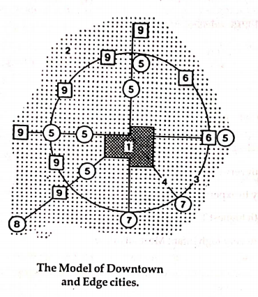
Question 13

Identify 9 in the given diagram.

  1. AOption (a)

    Central City

  2. BOption (b)

    Edge City

  3. COption (c)

    Residential suburb

  4. DOption (d)

    Airport

View answer & explanation

Correct answer

Answer: (b)B.

Edge City

Why this answer is correct

The correct answer is 'Edge City'

Key Points

  • Edge City:
  • An edge city is a concentration of business, shopping, and entertainment outside a traditional downtown or central business district, in what had previously been a residential or rural area.
  • The term was popularized by Joel Garreau in his 1991 book "Edge City: Life on the New Frontier."
  • Characteristics of edge cities include substantial amounts of office space, a high daytime population due to employment, a variety of retail options, and extensive entertainment and recreational facilities.
  • Edge cities typically develop near major highway intersections and are designed to be car-friendly, with extensive parking and road infrastructure.

Additional Information

  • Central City:
  • The central city, or downtown, is the main commercial and business center of a city, often characterized by skyscrapers, dense development, and a significant concentration of retail, office, and cultural institutions.
  • It is typically the historical core of the city and serves as the primary hub for transportation networks.
  • Residential Suburb:
  • Residential suburbs are areas located on the outskirts of a city, primarily composed of housing and residential neighborhoods.
  • These areas often offer a more spacious and quieter living environment compared to the central city, with amenities catering to family life, such as schools, parks, and shopping centers.
  • Airport:
  • An airport is a facility where aircraft take off and land, equipped with runways, terminals, and various support services for passengers and cargo.
  • Airports are strategically located to serve cities and regions, often positioned on the outskirts or in accessible locations connected by major transport routes.

Question 14

Identify the statements which are NOT correct.

A. The cartographic output quality of Vector model is very poor. 

B. Raster Data sets usually get originated from upper left corner.

C. Vector Model is the less compact data structure.

D. Geometrical figures shaping the raster cell and completely covering a flat surface are called tessellations.

Choose the correct answer from the options given below:

  1. AOption (a)

    C and D only

  2. BOption (b)

    B and C only

  3. COption (c)

    A and B only

  4. DOption (d)

    A and C only

View answer & explanation

Correct answer

Answer: (d)D.

A and C only

Why this answer is correct

The correct answer is: A and C only

Key Points


  • The cartographic output quality of Vector model is very poor:
  • This statement is incorrect.
  • The vector model is known for its high-quality cartographic output. It represents spatial data with precise geometry using points, lines, and polygons, which allows for clear and detailed map representations.
  • Raster Data sets usually get originated from upper left corner:
  • This statement is correct.
  • Raster data sets typically originate from the upper left corner. The data is organized in a grid of cells or pixels, and the origin point for reading and processing the cells is usually the top-left corner.
  • Vector Model is the less compact data structure:
  • This statement is incorrect.
  • The vector model is generally more compact compared to the raster model. Vector data efficiently represents spatial features without requiring a large amount of storage space, as it stores coordinates of points, lines, and polygons. Raster data can be less efficient because it must store values for each cell in a grid.
  • Geometrical figures shaping the raster cell and completely covering a flat surface are called tessellations:
  • This statement is correct.
  • Tessellations refer to the arrangement of shapes such as squares, triangles, or hexagons to completely cover a surface without gaps or overlaps. In the context of raster data, each cell in a grid can be considered a part of a tessellation.

Additional Information

  • Vector Model
  • Represents spatial data through coordinates and geometry using points, lines, and polygons.
  • Ideal for detailed and accurate cartography due to its high quality of representation.
  • More compact and efficient for representing geographical features with linear or complex boundaries.
  • Raster Model
  • Represents spatial data as a matrix of cells or pixels, each containing a value representing information such as color, elevation, or category.
  • Commonly used in image processing and remote sensing where data is naturally arrayed in a grid pattern.
  • Originates from the upper left corner and reads sequentially across rows.
  • Tessellations
  • Refers to the tiling of a plane using one or more geometric shapes with no overlaps and no gaps.
  • Common tessellation shapes include squares, triangles, and hexagons.
  • Tessellations form the basis of raster grid structures.
  • Comparing Raster and Vector Models:
  • Raster data can be less accurate and require more storage space than vector data, especially for large areas or high-resolution data.
  • Vector data is preferable for analyses requiring precision and detail, such as defining boundaries, networks, or features with sharp edges.

Question 15

Arrange the following countries in ascending order on the basis of density of population 2022.

A. Bhutan

B. Bangladesh

C. Switzerland

D. Monaco

Choose the correct answer from the options given below:

  1. AOption (a)

    B, A, D, C

  2. BOption (b)

    A, C, B, D

  3. COption (c)

    C, D, A, B

  4. DOption (d)

    D, B, C, A

View answer & explanation

Correct answer

Answer: (b)B.

A, C, B, D

Why this answer is correct

The correct answer is: (2) A, C, B, D

Key Points

  • Bhutan:
  • Bhutan has the lowest population density among the given countries.
  • As of 2022, Bhutan's population density is approximately 19 people per square kilometer.
  • The country is characterized by its mountainous terrain and small population, contributing to its low population density.
  • Switzerland:
  • Switzerland has a higher population density than Bhutan but lower than Bangladesh and Monaco.
  • In 2022, Switzerland's population density is around 219 people per square kilometer.
  • The country's population is concentrated in urban areas, with significant portions of land occupied by the Alps.
  • Bangladesh:
  • Bangladesh has a very high population density compared to Bhutan and Switzerland.
  • In 2022, the population density of Bangladesh is approximately 1,265 people per square kilometer.
  • The country is one of the most densely populated in the world, with a large population residing in a relatively small area.
  • Monaco:
  • Monaco has the highest population density among the given countries.
  • As of 2022, Monaco's population density is extraordinarily high at around 19,000 people per square kilometer.
  • Monaco is a small city-state on the Mediterranean coast, known for its affluent population and limited land area.

​​​​​

Additional Information 

  • Factors Influencing Population Density:
  • Geographical Features: Mountains, deserts, and other geographical barriers can limit population density.
  • Urbanization: Countries with a high level of urbanization tend to have higher population densities.
  • Economic Development: More economically developed countries can support higher population densities through better infrastructure and services.
  • Global Population Density Trends:
  • Countries with small land areas and high levels of urbanization, like Monaco and Singapore, have extremely high population densities.
  • Large countries with significant uninhabitable areas, such as deserts or mountains, tend to have lower population densities.
  • Implications of High Population Density:
  • Infrastructure Demand: High population densities increase the demand for housing, transportation, and public services.
  • Environmental Impact: Dense populations can lead to environmental challenges such as pollution and waste management issues.
  • Economic Opportunities: High population density can lead to greater economic opportunities and market size but also poses challenges in resource management.

Question 16

Which type of rural settlement pattern is formed where several roads converge?

  1. AOption (a)

    Rectangular

  2. BOption (b)

    T-shaped

  3. COption (c)

    Circular

  4. DOption (d)

    Star like

View answer & explanation

Correct answer

Answer: (d)D.

Star like

Why this answer is correct

The correct answer is 'Star like'

Key Points

  • Star-like Settlement Pattern:
  • This type of rural settlement pattern is formed where several roads converge at a central area, radiating outwards like the points of a star.
  • It is often seen in regions where many important roads meet, making it a central point for trade and communication.

Additional Information

  • Rectangular Pattern:
  • This pattern commonly forms in regions with a systematic and planned layout, often influenced by geographical features and land distribution practices.
  • T-shaped Pattern:
  • This pattern forms at the junction of two perpendicular roads or paths, resembling the shape of the letter 'T'.
  • Circular Pattern:
  • This type of settlement pattern typically forms around a central point such as a well, temple, or marketplace and resembles a circle.

Question 17

Friedmann's model is known as ______.

  1. AOption (a)

    Circular and Cumulative Causation

  2. BOption (b)

    Polarisation and Trickle Down Effects

  3. COption (c)

    Growth Pole

  4. DOption (d)

    Centro - Periphery

View answer & explanation

Correct answer

Answer: (d)D.

Centro - Periphery

Why this answer is correct

The correct answer is 'Centro - Periphery'

Key Points

  • Friedmann's Centro-Periphery Model:
  • John Friedmann's model describes the spatial structure of development and underdevelopment, where economic growth is concentrated in the 'center' (core areas), while the 'periphery' (outlying areas) remains less developed and dependent.
  • The model explains the dynamics of dominance and dependence between the central and peripheral regions.
  • It highlights how resources, power, and wealth tend to be concentrated in the core, leading to uneven development.

Additional Information

  • Circular and Cumulative Causation:
  • This concept, associated with economist Gunnar Myrdal, suggests that economic advantages tend to accumulate over time in certain regions, leading to a self-reinforcing cycle of growth.
  • Polarization and Trickle-Down Effects:
  • This concept involves the concentration of economic activities in particular regions (polarization) and the idea that benefits of growth will eventually spread to less developed areas (trickle-down effects).
  • Growth Pole:
  • This concept, developed by François Perroux, describes certain urban areas or industries that act as poles of economic growth, fostering development in their surrounding regions.

Question 18

Identify correct statements about Myrdal's model:  

A. He gave the theory of cumulative causation.

B. Some growth centres grow faster and work as suction pumps.

C. The spread of development to the surrounding region around the growth centre is called backwash effect.

D. Pulling of all the dynamic elements to the growth center from the surrounding locations is called take-off stage.

Choose the correct answer from the options given below:

  1. AOption (a)

    A and B only

  2. BOption (b)

    B and C only

  3. COption (c)

    C and D only

  4. DOption (d)

    B and D only

View answer & explanation

Correct answer

Answer: (a)A.

A and B only

Why this answer is correct

The correct answer is: A and B only

Key Points


  • He gave the theory of cumulative causation:
  • This statement is correct.
  • Gunnar Myrdal, a Swedish economist, introduced the theory of cumulative causation. This theory suggests that economic changes tend to build on themselves, leading to a self-reinforcing cycle of growth or decline.
  • Some growth centres grow faster and work as suction pumps:
  • This statement is correct.
  • Myrdal's model posits that certain growth centres, or hubs of economic activity, grow more rapidly than others. These centres can act like suction pumps, attracting resources, labor, and investment from surrounding areas, further accelerating their growth.
  • The spread of development to the surrounding region around the growth centre is called backwash effect:
  • This statement is incorrect.
  • The spread of development from a growth centre to surrounding areas is referred to as the "spread effect" or "trickle-down effect." The "backwash effect," on the other hand, refers to the opposite phenomenon where the growth centre pulls resources and talent from the surrounding areas, potentially leading to their decline.
  • Pulling of all the dynamic elements to the growth center from the surrounding locations is called take-off stage:
  • This statement is incorrect.
  • The take-off stage is a concept from Walt Rostow's "Stages of Economic Growth" theory, not Myrdal's model. In Myrdal's model, the pulling of dynamic elements into the growth centre is part of the "backwash effect."

Additional Information

  • Myrdal's theory of cumulative causation contrasts with the classical theory of economic equilibrium, highlighting how economic disparities can perpetuate themselves and even widen over time.
  • According to Myrdal, positive economic changes in a region can lead to further positive changes, creating a virtuous cycle of growth. Conversely, negative changes can lead to further decline, creating a vicious cycle of decline.
  • Myrdal emphasized the need for active policy intervention to counteract these self-reinforcing cycles, advocating for measures to promote regional development and reduce economic disparities.
  • Key terms in Myrdal's model include the "spread effect" (where economic growth in a region benefits surrounding areas) and "backwash effect" (where growth in a region drains resources from surrounding areas).

Question 19

Which of the following activities are not tied to resources, affected by the environment or necessarily localized by market?

  1. AOption (a)

    Primary

  2. BOption (b)

    Secondary

  3. COption (c)

    Heavy Industries 

  4. DOption (d)

    Quaternary

View answer & explanation

Correct answer

Answer: (d)D.

Quaternary

Why this answer is correct

The correct answer is 'Quaternary'

Key Points

  • Quaternary Activities:
  • The quaternary sector involves knowledge-based activities such as information technology, research and development, financial planning, education, consulting, and other services requiring a high level of expertise.
  • These activities are not directly tied to natural resources or affected by the physical environment.
  • They are not necessarily localized by market demands, as they can often be performed remotely and disseminated globally.

Additional Information

  • Primary Activities:
  • These activities involve the extraction of natural resources, such as agriculture, mining, and fishing, and are directly tied to the environment and localized by resource availability.
  • Secondary Activities:
  • These activities involve manufacturing and processing industries, which are often localized by access to raw materials, markets, and infrastructure.
  • Heavy Industries:
  • Heavy industries involve large-scale manufacturing and production, often requiring significant resources and infrastructure, and are influenced by environmental factors and market location.

Question 20

Identify correct statements about Agricultural Systems of the world.

A. Rearing of sheep on the ranches of North America and cattle in Australia are typical example of pastoral herding.

B. Quebracho tree grown in Mediterranean regions is a principal source of tannin

C. The cattle in the savannahs are kept for their hides and flesh.

D. Prairies is one of the most advanced commercial grazing region of the World.

Choose the correct answer from the options given below: `

  1. AOption (a)

    C and D only

  2. BOption (b)

    A and B only

  3. COption (c)

    B and C only

  4. DOption (d)

    A and D only

View answer & explanation

Correct answer

Answer: (a)A.

C and D only

Why this answer is correct

The correct answer is: C and D only

Key Points


  • The cattle in the savannahs are kept for their hides and flesh:
  • This statement is correct.
  • In the savannahs, cattle are primarily raised for their hides (leather production) and flesh (meat). This is a significant aspect of pastoralism in these regions, where the environment supports grazing but may not be conducive for extensive crop cultivation.
  • Prairies is one of the most advanced commercial grazing region of the World:
  • This statement is correct.
  • The Prairies in North America are known to be one of the most advanced commercial grazing regions in the world. The extensive grasslands and modern agricultural practices contribute to efficient livestock farming and high productivity in this region.
  • Rearing of sheep on the ranches of North America and cattle in Australia are typical example of pastoral herding:
  • This statement is incorrect.
  • While rearing sheep on ranches in North America and cattle in Australia involves aspects of pastoral herding, they are more accurately described under the umbrella of commercial ranching or livestock farming rather than traditional pastoral herding, which often implies nomadic or transhumant practices.
  • Quebracho tree grown in Mediterranean regions is a principal source of tannin:
  • This statement is incorrect.
  • The Quebracho tree, which is a principal source of tannin, is primarily found in South America, particularly in countries like Argentina and Paraguay, not in Mediterranean regions.

Additional Information

  • Agricultural Systems:
  • Agricultural systems around the world vary widely based on local climate, geography, economic development, and cultural practices.
  • Pastoral herding generally refers to the practice of raising large herds of animals (such as cattle, sheep, or goats) in extensive grazing areas, often involving some nomadic movement.
  • Commercial ranching is a more modern, intensive form of livestock farming, often found in countries like the USA, Australia, and Argentina, where animals are raised on large ranches for meat, milk, hides, and other products.
  • Quebracho Tree:
  • The Quebracho tree produces tannins, which are important in the leather tanning industry. It is found predominantly in the Gran Chaco region of South America.
  • Prairies:
  • The Prairies are vast grasslands that span across parts of the United States and Canada. They are ideal for grain farming and livestock grazing.
  • Savannahs:
  • The savannah regions, common in Africa, have a mixed agricultural system, with livestock being an important component. Animals like cattle are crucial for both commercial and subsistence farming systems.

Question 21

Identify the drainage order of circled stream, according to the Strahler's method:

  1. AOption (a)

    3rd order

  2. BOption (b)

    4th order

  3. COption (c)

    5th order

  4. DOption (d)

    2nd order

View answer & explanation

Correct answer

Answer: (b)B.

4th order

Why this answer is correct

The correct answer is '4th order'

Key Points

  • Strahler's Stream Order:
  • Strahler's method is a widely used system for classifying the hierarchy of streams in a drainage basin.
  • In this method, the smallest streams without any tributaries are designated as first-order streams.
  • When two first-order streams join, they form a second-order stream. When two second-order streams join, they form a third-order stream, and so on.
  • Therefore, the order increases only when two streams of the same order merge. If a higher-order stream is joined by a lower-order stream, the order remains the same as the higher-order stream.

Additional Information

  • 3rd Order Stream:
  • A third-order stream is formed by the confluence of two second-order streams.
  • It typically has a greater flow and wider channel compared to first- and second-order streams.
  • 5th Order Stream:
  • A fifth-order stream is formed by the confluence of two fourth-order streams.
  • It has even more significant flow and channel width, usually capable of supporting larger aquatic habitats.
  • 2nd Order Stream:
  • A second-order stream is formed by the confluence of two first-order streams.
  • It has a larger volume of water and channel compared to a first-order stream.

Question 22

Match List - I with List - II.

List - I
(Organism)
List - II
(Example)
A.ProducerI.Fungi
B.Primary consumerII.Chemosynthetic bacteria
C.Secondary consumerIII.Snake
D.DecomposerIV.Insect

Choose the correct answer from the options given below:

  1. AOption (a)

    A - IV, B - II, C - I, D - III

  2. BOption (b)

    A - II, B - IV, C - I, D - III

  3. COption (c)

    A - II, B - IV, C - III, D - I

  4. DOption (d)

    A - IV, B - II, C - III, D - I

View answer & explanation

Correct answer

Answer: (c)C.

A - II, B - IV, C - III, D - I

Why this answer is correct

The correct answer is: option 3) A - II, B - IV, C - III, D - I

Key Points

  1. Producer:
  • Producers are organisms that can produce their own food through processes like photosynthesis or chemosynthesis. Chemosynthetic bacteria are producers because they produce energy by oxidizing inorganic substances.
  • Match: Producer - Chemosynthetic bacteria (II)
  1. Primary consumer:
  • Primary consumers are herbivores that feed on producers. Insects often act as primary consumers by feeding on plants.
  • Match: Primary consumer - Insect (IV)
  1. Secondary consumer:
  • Secondary consumers are typically carnivores that feed on primary consumers. Snakes often act as secondary consumers by preying on animals like insects and rodents.
  • Match: Secondary consumer - Snake (III)
  1. Decomposer:
  • Decomposers break down dead organic material, returning nutrients to the environment. Fungi are common decomposers that play a crucial role in nutrient cycling.
  • Match: Decomposer - Fungi (I)

Additional Information

  • Chemosynthetic Bacteria: These bacteria derive energy from chemical processes (typically oxidation of inorganic compounds), making them producers in ecosystems like deep-sea vents.
  • Insects: Many insects feed directly on plants, making them primary consumers in various ecosystems.
  • Snakes: As secondary consumers, snakes often occupy higher trophic levels by preying on primary consumers and other small animals.
  • Fungi: As decomposers, fungi break down complex organic substances, contributing to the decomposition process and nutrient cycling in ecosystems.

Question 23

The word 'Nomothetic' stands for ______.

  1. AOption (a)

    Law seeking Discipline

  2. BOption (b)

    Descriptive sciences

  3. COption (c)

    Description of unique things

  4. DOption (d)

    Study of 'Nomads'

View answer & explanation

Correct answer

Answer: (a)A.

Law seeking Discipline

Why this answer is correct

The correct answer is 'Law seeking Discipline'

Key Points

  • Nomothetic:
  • The term 'Nomothetic' refers to an approach that seeks to establish general laws and principles.
  • It is associated with the search for generalizations and patterns that can be applied universally, often used in the context of scientific disciplines.

Additional Information

  • Descriptive Sciences:
  • Descriptive sciences focus on detailing and describing phenomena as they are observed, without necessarily establishing general laws.
  • Description of Unique Things:
  • This approach is more aligned with 'Idiographic' methods, which focus on the detailed study and description of unique, individual cases.
  • Study of 'Nomads':
  • The study of nomadic cultures and populations is typically anthropological and not related to the term 'Nomothetic'.

Question 24

Arrange the following surfaces in descending order of their albedo.

A. Water (Sun near zenith)

B. Cloud cover (Thin)

C. Fresh snow

D. Sand

Choose the correct answer from the options given below:

  1. AOption (a)

    B, C, A, D

  2. BOption (b)

    B, C, D, A

  3. COption (c)

    C, B, D, A

  4. DOption (d)

    C, B, A, D

View answer & explanation

Correct answer

Answer: (c)C.

C, B, D, A

Why this answer is correct

The correct answer is: C, B, D, A

Key Points

  • Albedo:
  • Albedo is a measure of the reflectivity of a surface, expressed as a percentage of the incoming sunlight that is reflected.
  • High albedo surfaces reflect more sunlight and appear brighter, while low albedo surfaces absorb more sunlight and appear darker.
  • Fresh Snow:
  • Fresh snow has the highest albedo among natural surfaces, typically reflecting 80-90% of sunlight.
  • This high reflectivity helps in cooling the Earth’s surface, especially in polar regions.
  • Cloud Cover (Thin):
  • Thin clouds have a moderate albedo, reflecting 30-50% of sunlight.
  • Clouds play a critical role in Earth's energy balance by reflecting sunlight back into space, which can help cool the surface below.
  • Sand:
  • Sand reflects about 30-40% of sunlight, making it moderately reflective.
  • Desert areas, with their vast sandy surfaces, contribute to the Earth's overall albedo but to a lesser extent than snow or clouds.
  • Water (Sun Near Zenith):
  • Water has a very low albedo, especially when the sun is directly overhead, reflecting only 3-10% of sunlight.
  • This low albedo allows water bodies to absorb significant amounts of solar energy, influencing the temperature and heat distribution in the environment.

Additional Information

  • Importance of Albedo:
  • Albedo is a critical factor in the Earth’s climate system, influencing temperature and weather patterns.
  • High albedo areas like ice caps help to reflect a significant portion of solar radiation, reducing the amount of heat absorbed by the Earth.
  • Changes in albedo, such as the melting of ice caps or deforestation, can contribute to global warming by decreasing the Earth's reflectivity and increasing heat absorption.
  • Climate Change Impact:
  • As global temperatures rise, surfaces with high albedo, such as ice and snow, are melting, leading to a decrease in the overall albedo of the Earth.
  • This reduction in albedo further accelerates global warming, as more solar energy is absorbed by darker, exposed surfaces like water and land.

Question 25

Match List - I with List - II.

List - I
(Books/Paper)
List - II
(Authors)
A.Early History of MankindI.Huntington
B.Exceptionalism in Geography : A Methodological examinationII.Brunhes
C.The Pulse of AsiaIII.Taylor
D.La Geographie HumaineIV.Schaefer

Choose the correct answer from the options given below:

  1. AOption (a)

    A - IV, B - III, C - I, D - II

  2. BOption (b)

    A - III, B - IV, C - I, D - II

  3. COption (c)

    A - III, B - IV, C - II, D - I

  4. DOption (d)

    A - IV, B - III, C - II, D - I

View answer & explanation

Correct answer

Answer: (b)B.

A - III, B - IV, C - I, D - II

Why this answer is correct

The correct answer is: option 2) A - III, B - IV, C - I, D - II

Key Points

  1. Early History of Mankind:
  • This book was written by Thomas Griffith Taylor.
  • Match: Early History of Mankind - Taylor (III)
  1. Exceptionalism in Geography: A Methodological Examination:
  • This paper was authored by Fred K. Schaefer.
  • Match: Exceptionalism in Geography: A Methodological Examination - Schaefer (IV)
  1. The Pulse of Asia:
  • This book was written by Ellsworth Huntington.
  • Match: The Pulse of Asia - Huntington (I)
  1. La Geographie Humaine:
  • This book was authored by Jean Brunhes.
  • Match: La Geographie Humaine - Brunhes (II)

Additional Information

  • Early History of Mankind: Thomas Griffith Taylor was a geographer and anthropologist known for his work in physical geography and environmental determinism.
  • Exceptionalism in Geography: A Methodological Examination: Fred K. Schaefer's seminal work challenged the concept of environmental determinism and argued for a more scientific and empirical approach in geography.
  • The Pulse of Asia: Ellsworth Huntington's book explores the environmental influences on human civilizations, particularly in Asia.
  • La Geographie Humaine: Jean Brunhes was a French geographer who made significant contributions to the development of human geography.

Question 26

According to _______, "Culture is that complex whole which includes knowledge, belief, art, moral, law, custom and any other capability acquired by man as a member of society".

  1. AOption (a)

    Knox

  2. BOption (b)

    Smith

  3. COption (c)

    Peet

  4. DOption (d)

    Tylor

View answer & explanation

Correct answer

Answer: (d)D.

Tylor

Why this answer is correct

The correct answer is 'Tylor'.

Key Points

  • Edward B. Tylor:
  • Edward Burnett Tylor is a pioneering figure in the field of anthropology, particularly known for his comprehensive definition of culture.
  • He defined culture in his work "Primitive Culture" (1871) as "that complex whole which includes knowledge, belief, art, morals, law, custom, and any other capabilities and habits acquired by man as a member of society."
  • Tylor's definition highlights the broad and inclusive nature of culture, encompassing various aspects of human life and social behavior.

Additional Information

  • Notable Contributions by Others:
  • Knox: Paul Knox currently serves as Senior Fellow for International Advancement, reporting directly to the university President. As a member of the Department of Urban Affairs and Planning he has taught courses on urban and regional development theory and comparative urbanization.
  • Smith: Neil Smith (1954-2012) was a Scottish geographer and activist intellectual, whose prolific, passionate and politically engaged writings played a significant role in shaping the present day landscape of urban studies, human geography, and indeed the entire spectrum of the social sciences.
  • Peet: Richard (Dick) J. Peet started a new intellectual movement within the discipline of geography, a radical turn that came to be known as ‘radical geography.’ Radical geography re-calibrated the discipline towards issues of social relevance like poverty, inequality, critique of capitalist exploitation in the global north and south, critique of Euro-Anglo centric development and modernity, studies of uneven development, nature’s exploitation, politics of space and ecology.

Question 27

Identify the correct statements with reference to biogeochemical cycle.

A. It involves both physical and biological processes.

B. It is also referred to as a material cycle or nutrition cycle.

C. Of all the biogeochemical cycles, the nitrogen cycle is the most important as nitrogen makes up 78% of the atmosphere.

D. In biogeochemical cycle the movement of materials is unidirectional.

Choose the correct answer from the options given below:

  1. AOption (a)

    A, B and C only

  2. BOption (b)

    A and B only

  3. COption (c)

    B and C only

  4. DOption (d)

    A, C and D only

View answer & explanation

Correct answer

Answer: (b)B.

A and B only

Why this answer is correct

The correct answer is: A and B only

Key Points


  • It involves both physical and biological processes:
  • This statement is correct.
  • Biogeochemical cycles involve the circulation of elements and compounds through both biological (living organisms) and physical (geological and chemical) processes.
  • For example, the carbon cycle includes processes like photosynthesis (biological) and sedimentation (physical).
  • It is also referred to as a material cycle or nutrition cycle:
  • This statement is correct.
  • Biogeochemical cycles are also known as material cycles or nutrient cycles because they describe the flow of chemical elements and compounds between living organisms and the physical environment, ensuring that nutrients are circulated and reused.
  • The nitrogen cycle is the most important as nitrogen makes up 78% of the atmosphere:
  • This statement is incorrect.
  • While nitrogen is a crucial element for life and makes up a significant portion of the Earth's atmosphere, stating that the nitrogen cycle is the most important of all biogeochemical cycles is subjective. Other cycles, such as the carbon and water cycles, are also vital for life and ecosystem functioning.
  • In biogeochemical cycle, the movement of materials is unidirectional:
  • This statement is incorrect.
  • The movement of materials in biogeochemical cycles is not unidirectional but cyclical.
  • Elements move through different reservoirs (e.g., atmosphere, biosphere, lithosphere) in a continuous loop, ensuring that they are constantly recycled and reused.

Additional Information

  • Biogeochemical Cycles:
  • Biogeochemical cycles describe the movement of chemical elements and compounds between living organisms and the physical environment. These cycles are essential for maintaining ecosystem health and supporting life.
  • Examples of biogeochemical cycles include the carbon cycle, nitrogen cycle, water cycle, and phosphorus cycle.
  • Importance of Various Cycles:
  • Each biogeochemical cycle plays a unique and crucial role in sustaining life. For instance, the water cycle is essential for distributing water across the planet, while the carbon cycle is critical for regulating the Earth's climate and supporting photosynthesis.
  • While the nitrogen cycle is vital for incorporating nitrogen into biological molecules such as amino acids and nucleic acids, it is not necessarily more important than other cycles.
  • Cyclic Nature of Biogeochemical Cycles:
  • These cycles are inherently cyclical, meaning that the elements continuously move back and forth between different states and locations. For example, carbon moves between the atmosphere and biosphere through processes like respiration and photosynthesis.

Question 28

∑i=jn(Xi−X‾)2N\rm \sqrt{\frac{\displaystyle \sum_{i=j}^n\left(X_i-\overline{X}\right)^2}{N}} is used to calculate _______.

  1. AOption (a)

    Mean Deviation

  2. BOption (b)

    Coefficient of variation

  3. COption (c)

    Standard Deviation

  4. DOption (d)

    Skewness

View answer & explanation

Correct answer

Answer: (c)C.

Standard Deviation

Why this answer is correct

The correct answer is 'Standard Deviation'

Key Points

  • Standard Deviation:
  • Standard Deviation is a measure of the amount of variation or dispersion in a set of values.
  • It is calculated as the square root of the variance, which is the average of the squared differences from the mean.
  • The formula for Standard Deviation is: [ \sigma = \sqrt{\frac{\sum_{i=1}^{n} (X_i - \overline{X})^2}{N}} \],
  • where
  • (Xi( X_i ) is each value in the data set,
  • (X‾( \overline{X} ) is the mean of the data set, and
  • (N( N ) is the number of data points.
  • Standard Deviation is widely used in statistics, finance, and various fields to assess the risk and variability of data sets.

Additional Information

  • Mean Deviation:
  • Mean Deviation, also known as the average absolute deviation, is the average of the absolute differences between each data point and the mean of the data set.
  • It provides a simple measure of variability but is less commonly used than Standard Deviation.
  • Coefficient of Variation:
  • The Coefficient of Variation (CV) is a normalized measure of the dispersion of a probability distribution, calculated as the ratio of the Standard Deviation to the mean.
  • It is useful for comparing the degree of variation between different data sets, especially when the means differ significantly.
  • Skewness:
  • Skewness measures the asymmetry of the probability distribution of a real-valued random variable about its mean.
  • Positive skewness indicates a distribution with an asymmetric tail extending towards more positive values, while negative skewness indicates a tail extending towards more negative values.

Question 29

Arrange the following folds based on position of axial plane from horizontal to vertical.

A. Asymmetrical fold

B. Overfold 

C. Recumbent fold

D. Symmetrical fold

Choose the correct answer from the options given below:

  1. AOption (a)

    D, A, C, B

  2. BOption (b)

    D, A, B, C

  3. COption (c)

    C, B, A, D

  4. DOption (d)

    C, D, A, B

View answer & explanation

Correct answer

Answer: (c)C.

C, B, A, D

Why this answer is correct

The correct answer is: 3 - C, B, A, D

In structural geology, the orientation of an axial plane is crucial in understanding the types of folds present in rock layers. The axial plane is an imaginary surface that divides a fold symmetrically into two limbs. The position of the axial plane relative to the horizontal can help identify different types of folds. These folds are categorized based on the angle and direction of the axial plane, ranging from nearly horizontal to vertical.

Key Points

Types of Folds Based on the Position of Axial Plane:

  • Recumbent Fold (C):
  • The axial plane is nearly horizontal.
  • The fold limbs are also nearly horizontal, indicating that the fold has been tilted to a great extent.
  • Recumbent folds are indicative of intense deformation and can be associated with high-pressure environments such as those found in convergent tectonic boundaries.
  • Overfold (B):
  • The axial plane is moderately to steeply inclined, but not vertical.
  • One limb of the fold is overturned relative to the other, making it a type of asymmetrical fold but with extreme deformation.
  • Overfolds often result from differential stress leading to one limb being pushed over the other.
  • Asymmetrical Fold (A):
  • The axial plane is inclined, instead of being vertical or horizontal.
  • One limb dips more steeply than the other, leading to an asymmetrical shape.
  • The difference in limb angles suggests varying levels of stress during formation.
  • Symmetrical Fold (D):
  • The axial plane is vertical or near-vertical.
  • Both limbs of the fold are mirror images of each other, dipping at equal angles.
  • Symmetrical folds are generally formed under relatively uniform stress conditions.

Additional Information

  • The understanding of fold types based on the axial plane orientation is important for geologists to interpret geological structures and the tectonic history of a region.
  • Recumbent folds can indicate significant horizontal compression, whereas symmetrical folds can imply more moderate stress conditions.
  • In the field of petroleum geology, knowing the types of folds and their orientations can help in predicting the presence of hydrocarbons, as these folds can serve as potential traps.
  • Additionally, folds can also influence the distribution of mineral resources, groundwater flow, and the stability of structures built on these folded terrains.
  • A comprehensive understanding of folding processes and axial plane positions can also aid in seismic interpretation and risk assessment in areas prone to earthquakes.

Question 30

The credit of originating the literary tradition in Geography goes to _______.

  1. AOption (a)

    Herodotus

  2. BOption (b)

    Ptolemy

  3. COption (c)

    Hipparchus

  4. DOption (d)

    Hecataeus

View answer & explanation

Correct answer

Answer: (d)D.

Hecataeus

Why this answer is correct

The correct answer is 'Hecataeus.'

Key Points

  • Hecataeus:
  • Hecataeus of Miletus is considered one of the pioneers in the field of geography.
  • He is credited with originating the literary tradition in geography through his work "Ges Periodos" (Travels Around the Earth) which combined descriptions of the known world with mythological and historical accounts.
  • His works laid the foundation for later geographical traditions and influenced subsequent geographers like Herodotus and Ptolemy.

Additional Information

  • Other notable figures in ancient geography:
  • Herodotus: Often called the 'Father of History', Herodotus also made significant contributions to geography through his detailed descriptions of different regions and peoples in his work "Histories."
  • Ptolemy: Known for his work "Geographia," Ptolemy compiled and expanded upon the geographical knowledge of his time and introduced the concept of using coordinates for mapping.
  • Hipparchus: Made significant contributions to astronomy and geography, particularly in the development of coordinate systems and the use of latitude and longitude for mapping the earth.

Question 31

The phenomenon of energy loss in successive trophic levels is approximated as the ______ rule.

  1. AOption (a)

    10 percent

  2. BOption (b)

    20 percent

  3. COption (c)

    30 percent

  4. DOption (d)

    40 percent

View answer & explanation

Correct answer

Answer: (a)A.

10 percent

Why this answer is correct

The correct option is '10 percent'.

Key Points

  • The 10 percent rule in ecology refers to the concept that only about 10 percent of the energy at one trophic level is passed on to the next trophic level.
  • This rule was first introduced by ecologist Raymond Lindeman in 1942, illustrating how energy diminishes as it flows through the food chain.
  • The majority (about 90 percent) of the energy is used by the organism for metabolic processes such as respiration, growth, and reproduction, or is lost as heat.
  • For example, if a primary producer (like a plant) captures 1000 units of energy from sunlight, only about 100 units of that energy will be available to primary consumers (herbivores).
  • Similarly, when primary consumers are eaten by secondary consumers (carnivores), only about 10 units of energy will be transferred from primary consumers to secondary consumers.
  • This explains why higher trophic levels have less energy available and generally support fewer individuals.

Additional Information

  • The 10 percent rule highlights the inefficiency of energy transfer in ecosystems and underscores the importance of lower trophic levels in supporting the larger food web.
  • Because of this energy loss, ecosystems typically have a pyramid structure, with a broad base of primary producers and a few top predators.

Question 32

Arrange the following relief features on the basis of their genesis chronology.

A. Vosges mountains

B. Scandinavian highlands

C. Siberian shield   

D. Atlas mountains

Choose the correct answer from the options given below:

  1. AOption (a)

    C, B, A, D

  2. BOption (b)

    D, B, A, C

  3. COption (c)

    B, C, D, A

  4. DOption (d)

    A, B, D, C

View answer & explanation

Correct answer

Answer: (a)A.

C, B, A, D

Why this answer is correct

The correct answer is: C, B, A, D.

Key Points

  • Siberian Shield
  • The Siberian Shield, also known as the Siberian Craton, is one of the oldest geological formations on Earth.
  • It formed during the Precambrian era, over 2.5 billion years ago.
  • This ancient rock formation is located in the northern part of Russia and represents some of the earliest continental crust.
  • Scandinavian Highlands
  • The Scandinavian Highlands, also known as the Scandinavian Mountains or Scandes, are a range of mountains that formed primarily during the Caledonian orogeny.
  • This orogeny occurred around 490 to 390 million years ago during the Late Silurian to Early Devonian periods.
  • The formation of these highlands is linked to the collision between the Laurentian, Baltic, and Avalonian plates.
  • Vosges Mountains
  • The Vosges Mountains are located in eastern France and are part of the Hercynian orogeny.
  • This mountain range was primarily formed during the Carboniferous period, around 359 to 299 million years ago.
  • The formation of the Vosges Mountains is associated with the collision of tectonic plates that created a series of fold mountains in Europe.
  • Atlas Mountains
  • The Atlas Mountains are a mountain range in northwest Africa, extending through Morocco, Algeria, and Tunisia.
  • This range formed relatively recently in geological terms during the Cenozoic era, primarily in the Paleogene and Neogene periods, around 65 to 2.5 million years ago.
  • The formation of the Atlas Mountains is linked to the collision between the African and Eurasian tectonic plates.

Additional Information

  • Historical Context:
  • These relief features were formed at different times due to various geological processes, including plate tectonics, volcanic activity, and erosion.
  • Significance:
  • Each of these geological formations plays a significant role in the current topography and biodiversity of their respective regions.
  • Geological Importance:
  • Studying these formations helps scientists understand the Earth's geological history and the processes that have shaped its surface.
  • Modern Relevance:
  • These geological features continue to influence climate, weather patterns, and human activities in their regions.

Question 33

Identify the correct statements with reference to Geomorphic Cycles of Davis and Penck.

A. Davis considered the cycle of erosion of fluvial process as the 'normal cycle of erosion'.

B. Davis used the concept of 'base level' proposed by Gilbert and concept of 'graded streams' propounded by Powell and applied 'evolutionary paradigm'.

C. In the second sub-phase of the phase of uniform development of landscape of Penck model absolute height increases and relative relief also increases at the same rate.

D. Davis applied the concept of slope decline.

Choose the correct answer from the options given below:

  1. AOption (a)

    A, B and C only

  2. BOption (b)

    A and D only

  3. COption (c)

    B, C and D only

  4. DOption (d)

    A and C only

View answer & explanation

Correct answer

Answer: (b)B.

A and D only

Why this answer is correct

The correct answer is: A and D only

Key Points


  • Davis considered the cycle of erosion of fluvial process as the 'normal cycle of erosion':
  • This statement is correct.
  • William Morris Davis' geomorphic cycle, also known as the cycle of erosion, primarily focuses on the fluvial process. He described it as the 'normal cycle of erosion', which includes the stages of youth, maturity, and old age for landscapes shaped by river erosion.
  • Davis applied the concept of slope decline:
  • This statement is correct.
  • Davis suggested that slopes gradually decline over time due to continuous erosion, which leads to a reduction in their steepness until a peneplain—a nearly level surface—is formed.
  • Davis used the concept of 'base level' proposed by Gilbert and the concept of 'graded streams' propounded by Powell and applied 'evolutionary paradigm':
  • This statement is incorrect.
  • Although Davis did integrate various concepts from other geomorphologists like the base level and graded streams, the primary focus of his work was on the sequential development of landscapes through erosion rather than a strict adherence to these specific theories. His approach was more about the stages of landscape evolution.
  • In the second sub-phase of the phase of uniform development of landscape of Penck model absolute height increases and relative relief also increases at the same rate:
  • This statement is incorrect.
  • According to Walther Penck's model, the development of landscape includes more complexity with multiple phases of uplift and erosion. The statement oversimplifies Penck's views, as he considered varying rates of uplift and erosion influencing the landscape differently over time.

Additional Information

  • Davis' Geomorphic Cycle:
  • Davis proposed a model of landscape evolution characterized by a systematic process of uplift followed by erosion. He identified three main stages—youth, maturity, and old age—through which landscapes evolve.
  • He emphasized the gradual decline of slopes as a significant factor in shaping the morphology of a region over geological time.
  • Penck's Geomorphic Model:
  • Penck challenged Davis' ideas by introducing the concept of parallel slope retreat and the notion that uplift and erosion can occur simultaneously at varying rates, resulting in more dynamic and continuous landscape changes.
  • He proposed that relative and absolute relief could change differently depending on the rates of tectonic uplift and erosion, offering a more nuanced and complex view of landscape development.

Question 34

Which of the following law gives an insight about the amount of radiation radiated by an object in different parts of Electromagnetic spectrum?

  1. AOption (a)

    Wein's Displacement law

  2. BOption (b)

    Stefen Baltzman law

  3. COption (c)

    Plank's law

  4. DOption (d)

    Kirchoff's law

View answer & explanation

Correct answer

Answer: (c)C.

Plank's law

Why this answer is correct

The correct answer is 'Planck's law.'

Key Points

  • Planck's Law:
  • Planck's law describes the spectral distribution of electromagnetic radiation emitted by a black body in thermal equilibrium at a definite temperature.
  • It provides an insight into the amount of radiation radiated at different wavelengths (or frequencies) across the electromagnetic spectrum.
  • Planck's law is fundamental in understanding how the intensity of radiation varies with wavelength for different temperatures.

Additional Information

  • Comparison with other laws:
  • Wein's Displacement Law: Describes the relationship between the temperature of a black body and the wavelength at which it emits radiation most strongly. It helps determine the peak wavelength but doesn't describe the full spectrum.
  • Stefan-Boltzmann Law: States that the total energy radiated per unit surface area of a black body is proportional to the fourth power of its temperature. It gives the total power emitted but not the distribution across wavelengths.
  • Kirchhoff's Law: Relates to the emissive and absorptive properties of materials, stating that for a body in thermal equilibrium, the emissivity is equal to the absorptivity at every wavelength. It contributes to the foundation of understanding black body radiation, but doesn't describe the spectral distribution.

Question 35

Arrange the following countries in ascending order on the basis of percent share in exports of commercial services in the world.

A. Brazil

B. Netherlands

C. Thailand

D. U.K

Choose the correct answer from the options given below:

  1. AOption (a)

    A, B, C, D

  2. BOption (b)

    A, C, B, D

  3. COption (c)

    D, B, A, C

  4. DOption (d)

    C, D, B, A

View answer & explanation

Correct answer

Answer: (b)B.

A, C, B, D

Why this answer is correct

The correct answer is: (2) A, C, B, D

Key Points

  • Brazil:
  • Brazil's share in the global export of commercial services is relatively low compared to other major economies.
  • The country primarily focuses on exporting commodities and raw materials rather than services.
  • Service sectors in Brazil, such as tourism and finance, contribute less to global commercial service exports.
  • Thailand:
  • Thailand has a higher share of global commercial service exports than Brazil.
  • The country's economy benefits from tourism, which significantly contributes to its service exports.
  • Additionally, sectors like healthcare services, education, and professional services also play a role in Thailand's export profile.
  • Netherlands:
  • The Netherlands has a substantial share in the export of commercial services globally.
  • The country is a major hub for logistics, transportation, and financial services in Europe.
  • Its strategic location and advanced infrastructure enhance its role in international trade and service exports.
  • U.K:
  • The U.K. has one of the highest shares in the global export of commercial services.
  • Key service sectors include financial services, insurance, legal services, and education.
  • London is a leading global financial center, contributing significantly to the U.K.'s commercial service exports.

​​​​​

Additional Information 

  • Global Trade in Commercial Services:
  • Commercial services include sectors such as finance, insurance, real estate, business services, and information technology.
  • Countries with advanced infrastructure and diversified economies tend to have a higher share in global service exports.
  • Importance of Service Exports:
  • Service exports contribute significantly to the GDP and economic growth of many countries.
  • They provide employment opportunities and help in diversifying the economy.
  • Service exports are less susceptible to physical constraints and can be more resilient to economic shocks compared to goods exports.
  • Factors Influencing Service Exports:
  • Economic Policies: Supportive government policies and trade agreements boost service exports.
  • Technological Advancements: Enhanced technology facilitates the delivery of services across borders.
  • Skilled Workforce: Availability of a skilled and educated workforce is crucial for service sectors.

Question 36

Which of the following term denotes attributes of separation between the location of origin and the location of destination in Spatial Interaction model?

  1. AOption (a)

    Sij

  2. BOption (b)

    Wj

  3. COption (c)

    Vi

  4. DOption (d)

    Tij

View answer & explanation

Correct answer

Answer: (a)A.

Sij

Why this answer is correct

The correct answer is 'Sij'

Key Points

  • Sij:
  • In the Spatial Interaction model, the term 'Sij' denotes attributes of separation between the location of origin (i) and the location of destination (j).
  • Attributes of separation can include factors such as distance, travel time, cost, and other impedance factors that affect the ease or difficulty of interaction between two locations.

Additional Information

  • Other terms in Spatial Interaction Model:
  • Wj: Often represents the attractiveness or the weight of the destination (j), such as its economic size or population.
  • Vi: Represents the volume or the potential of the origin (i), which could be related to its population or production capacity.
  • Tij: Typically denotes the interaction or the flow between origin (i) and destination (j), like the number of trips, amount of goods transported, or any other measure of interaction.

Question 37

Which of the following was not assumed by Weber in Industrial Location Theory? 

  1. AOption (a)

    Isotropic surface

  2. BOption (b)

    Perfect knowledge about location of raw materials and market

  3. COption (c)

    Enterpreneurs are economic and rational men

  4. DOption (d)

    Labour is cheap and easily available at all places

View answer & explanation

Correct answer

Answer: (d)D.

Labour is cheap and easily available at all places

Why this answer is correct

The correct answer is 'Labour is cheap and easily available at all places.'

Key Points

  • Weber's Industrial Location Theory Assumptions:
  • Isotropic surface: Weber assumed an isotropic plain, meaning a featureless flat area where conditions are the same in all directions.
  • Perfect knowledge: Assumed that entrepreneurs have perfect knowledge about the location of raw materials and the market, enabling them to minimize costs efficiently.
  • Economic and rational men: Assumed that entrepreneurs are rational beings who aim to maximize profits and minimize costs, making decisions based on economic factors.

Additional Information

  • Labour cost and availability:
  • Weber did not assume that labor is cheap and easily available at all places. In fact, varying labor costs and availability are considered critical factors influencing the location of industries.
  • Weber's model emphasizes that industries tend to locate where labor costs are lower and labor is suitably skilled and available.
  • Additional Assumptions:
  • Transport costs are a key factor and vary linearly with distance.
  • There is only one product being produced, and it requires raw materials from specific sources.
  • There is a single market for the produced goods.

Question 38

_______ is NOT included in the 15 agroclimatic regions of India classified by the Planning Commission.

  1. AOption (a)

    The Thar desert

  2. BOption (b)

    The Western Rajasthan

  3. COption (c)

    The Middle Ganga Plain

  4. DOption (d)

    The Northeastern region

View answer & explanation

Correct answer

Answer: (a)A.

The Thar desert

Why this answer is correct

The correct answer is 'The Thar desert'

Key Points

  • Agroclimatic regions:
  • The Planning Commission of India classified the country into 15 agroclimatic regions to better align agricultural practices with climatic conditions and achieve sustainable agricultural development.
  • Among the options given, 'The Thar desert' is not included as a separate agroclimatic region. Instead, the Thar desert is part of the "Western Rajasthan" agroclimatic region.
  • The other options, namely 'The Western Rajasthan,' 'The Middle Ganga Plain,' and 'The Northeastern region,' are included in the 15 agroclimatic regions classified by the Planning Commission.

Additional Information

  • Classification by the Planning Commission:
  • The aim is to optimize resource use and increase agricultural productivity within each specific climatic zone.
  • The classification takes into account factors like rainfall, temperature, soil types, and agricultural practices.
  • Existing agroclimatic regions include:
  • Western Himalayan Region
  • Eastern Himalayan Region
  • Lower Gangetic Plain Region
  • Middle Gangetic Plain Region
  • Upper Gangetic Plain Region
  • Trans-Gangetic Plain Region
  • Eastern Plateau and Hills
  • Central Plateau and Hills
  • Western Plateau and Hills
  • Southern Plateau and Hills
  • East Coast Plains and Hills
  • West Coast Plains and Hills
  • Gujarat Plains and Hills
  • The Western Dry Region (includes Western Rajasthan)
  • The Islands Region

Question 39

Arrange the following satellites and sensors in ascending order of their spatial resolution.

A. IKONOS-MS

B. Cartosat 2-PAN

C. Resourcesat 2A - LISS - IV

D. Orbview-PAN

Choose the correct answer from the options given below:

  1. AOption (a)

    B, D, A, C

  2. BOption (b)

    D, B, A, C

  3. COption (c)

    B, D, C, A

  4. DOption (d)

    C, A, D, B

View answer & explanation

Correct answer

Answer: (a)A.

B, D, A, C

Why this answer is correct

The Correct answer is: "B, D, A, C"

Key Points

  • Cartosat-2 PAN (B):
  • Cartosat-2 Panchromatic sensor offers the highest spatial resolution in the list, at 0.8 meters.
  • Used extensively in defense, urban development, and infrastructure planning due to its ability to capture precise, high-resolution details.
  • Operates in a single spectral band, focusing on fine spatial details.
  • OrbView-PAN (D):
  • The OrbView Panchromatic sensor has a spatial resolution of 1 meter.
  • Captures fine details of smaller objects, making it suitable for applications like cadastral mapping, urban planning, and surveillance.
  • Provides black-and-white imagery, which is highly detailed.
  • IKONOS-MS (A):
  • IKONOS multispectral sensors have a resolution of 4 meters, providing detailed imagery with multiple spectral bands.
  • Applications include land use mapping, environmental monitoring, and urban planning.
  • It is slightly more precise than Resourcesat-2A LISS-IV.
  • Resourcesat-2A LISS-IV (C):
  • Linear Imaging Self Scanner-IV (LISS-IV) onboard Resourcesat-2A offers a spatial resolution of 5.8 meters.
  • Primarily used for agricultural monitoring, urban planning, and disaster management.
  • Provides data in visible and near-infrared bands, covering larger areas compared to higher-resolution sensors.

Additional Information

  • Spatial Resolution:
  • Spatial resolution determines the smallest object that can be detected in an image. A smaller resolution value indicates higher detail.
  • Lower spatial resolution sensors (e.g., LISS-IV) are better for covering large areas, while higher resolution sensors (e.g., Cartosat-2 PAN) are suited for detailed analysis of smaller areas.
  • Applications:
  • Resourcesat-2A LISS-IV: Agriculture, forestry, and disaster management.
  • IKONOS-MS: Urban planning and environmental studies.
  • OrbView-PAN: Urban development and security purposes.
  • Cartosat-2 PAN: High-precision mapping and defense applications.

Question 40

Which of the following will improve economic life of rural areas in developing countries, reduce environmental pollution, enhance self-reliance and reduce pressure on fuel wood?

  1. AOption (a)

    Tidal energy

  2. BOption (b)

    Bio-energy

  3. COption (c)

    Geothermal energy

  4. DOption (d)

    Nuclear energy

View answer & explanation

Correct answer

Answer: (b)B.

Bio-energy

Why this answer is correct

The correct answer is 'Bio-energy'

Key Points

  • Bio-energy:
  • Bio-energy, derived from organic materials such as agricultural residue, animal waste, and plant material, is a renewable resource that can be used to produce heat, electricity, and biofuels.
  • Its use can significantly improve the economic life of rural areas by providing a sustainable source of energy, which in turn supports agricultural productivity and local industries.
  • By utilizing waste materials and crops grown specifically for energy purposes, bio-energy reduces environmental pollution and the dependency on fossil fuels.
  • Enhanced self-reliance comes from producing energy locally, and the reduced pressure on fuel wood helps in preserving natural forests and ecosystems.

Additional Information

  • Tidal energy:
  • Tidal energy is renewable and environmentally friendly, but it is confined to coastal areas and requires significant infrastructure investment, which may not be feasible for widespread rural application in developing countries.
  • Geothermal energy:
  • Geothermal energy is highly location-specific, depending on the presence of geothermal reservoirs, and may require advanced technology and substantial investment, limiting its applicability in widespread rural areas of developing countries.
  • Nuclear energy:
  • Nuclear energy provides a large amount of power but involves high costs, complex technology, and significant safety and environmental concerns, making it impractical for improving the economic life of rural areas directly.

Question 41

________ introduced the concept of Clean Development Mechanisms.

  1. AOption (a)

    Convention on Biological Diversity

  2. BOption (b)

    Montreal Protocol

  3. COption (c)

    Paris Agreement

  4. DOption (d)

    Kyoto Protocol

View answer & explanation

Correct answer

Answer: (d)D.

Kyoto Protocol

Why this answer is correct

The correct answer is 'Kyoto Protocol'

Key Points

  • Kyoto Protocol:
  • The Kyoto Protocol, adopted in 1997 and entering into force in 2005, is an international treaty that commits its parties to reduce greenhouse gas emissions, based on the premise that global warming exists and human-made CO2 emissions have caused it.
  • The Clean Development Mechanism (CDM) is a flexible mechanism defined in Article 12 of the Kyoto Protocol.
  • CDM allows industrialized countries to invest in projects that reduce emissions in developing countries as an alternative to more costly emission reductions in their own countries.

Additional Information

  • Convention on Biological Diversity:
  • The Convention on Biological Diversity (CBD) is a multilateral treaty with the goal of developing national strategies for the conservation and sustainable use of biological diversity.
  • It does not focus on mechanisms for emission reduction like CDM.
  • Montreal Protocol:
  • The Montreal Protocol, adopted in 1987, is an international treaty designed to phase out the production and consumption of substances that deplete the ozone layer.
  • It does not include the concept of Clean Development Mechanisms.
  • Paris Agreement:
  • The Paris Agreement, adopted in 2015, aims to limit global warming to well below 2 degrees Celsius above pre-industrial levels.
  • It builds on the Kyoto Protocol's efforts but does not specifically introduce the CDM, though it includes other mechanisms for emission reduction.

Question 42

Which of the following mountain ranges of Peninsular India has the highest peak? 

  1. AOption (a)

    Western Ghat

  2. BOption (b)

    Vindhyan Range 

  3. COption (c)

    Aravalli Range

  4. DOption (d)

    Satpura Range

View answer & explanation

Correct answer

Answer: (a)A.

Western Ghat

Why this answer is correct

The correct answer is 'Western Ghat'

Key Points

  • Western Ghats:
  • The Western Ghats, also known as the Sahyadri, are a mountain range that runs parallel to the western coast of India.
  • The highest peak in the Western Ghats is Anamudi, which stands at an elevation of 2,695 meters (8,842 feet) above sea level.
  • Anamudi is the highest peak in Peninsular India and is located in the state of Kerala.

Additional Information

  • Vindhyan Range:
  • The Vindhyan Range runs across central India, acting as a natural barrier between North and South India. Its highest peak is Kalumar Peak at 752 meters (2,467 feet).
  • Aravalli Range:
  • The Aravalli Range, which runs across northwestern India, has its highest peak at Guru Shikhar, which stands at 1,722 meters (5,650 feet) above sea level in Rajasthan.
  • Satpura Range:
  • The Satpura Range, located in central India, has its highest peak at Dhupgarh, which stands at 1,350 meters (4,429 feet) above sea level in Madhya Pradesh.

Question 43

Match List - I with List - II.

List - I
(Symbol)
List - II
(Koppen's climate type)
A.AwI.Steppe climate
B.BSII.Perpetual frost climate
C.CsIII.Tropical Savanna
D.EFIV.Mild humid climate with a dry summer

Choose the correct answer from the options given below:

  1. AOption (a)

    A - III, B - I, C - IV, D - II

  2. BOption (b)

    A - I, B - III, C - IV, D - II

  3. COption (c)

    A - III, B - I, C - II, D - IV

  4. DOption (d)

    A - I, B - III, C - II, D - IV

View answer & explanation

Correct answer

Answer: (a)A.

A - III, B - I, C - IV, D - II

Why this answer is correct

The correct answer is: 1 - A - III, B - I, C - IV, D - II.

Key Points

Symbol (List I)Koppen's Climate Type (List II)
(A) Aw(III) Tropical Savanna
(B) BS(I) Steppe climate
(C) Cs(IV) Mild humid climate with a dry summer
(D) EF(II) Perpetual frost climate


Additional Information

  • Aw - Tropical Savanna:
  • Definition: This climate type is characterized by a distinct dry season and a wet season, found in regions near the equator.
  • Features: High temperatures throughout the year with seasonal rainfall.
  • Examples: Parts of India, Brazil, and Africa.
  • BS - Steppe climate:
  • Definition: Steppe climate represents semi-arid regions with sparse vegetation, located between deserts and humid climates.
  • Features: Low precipitation, high temperature variation, and grasslands.
  • Examples: Great Plains in the USA, Central Asia.
  • Cs - Mild humid climate with a dry summer:
  • Definition: Also known as the Mediterranean climate, it features mild, wet winters and hot, dry summers.
  • Features: Moderate rainfall, favorable for agriculture.
  • Examples: California, Southern Europe, parts of Australia.
  • EF - Perpetual frost climate:
  • Definition: This climate type is characterized by extremely cold conditions, with temperatures always below freezing.
  • Features: Permanent ice cover and no vegetation.
  • Examples: Antarctica, Greenland.

Question 44

The earthquakes on the Pacific coast of Mexico are associated with the subduction boundary of the _______ plate.

  1. AOption (a)

    Cocos

  2. BOption (b)

    Nazca

  3. COption (c)

    Juan de Fuca

  4. DOption (d)

    North Atlantic

View answer & explanation

Correct answer

Answer: (a)A.

Cocos

Why this answer is correct

The correct answer is 'Cocos Plate'

Key Points

  • Cocos Plate:
  • The Cocos Plate is an oceanic tectonic plate beneath the Pacific Ocean off the west coast of Central America.
  • The subduction of the Cocos Plate beneath the North American Plate along the Pacific coast of Mexico is responsible for many of the region’s earthquakes.
  • This subduction zone is part of the larger Pacific Ring of Fire, which is known for its significant seismic activity.

Additional Information

  • Nazca Plate:
  • The Nazca Plate subducts beneath the South American Plate, contributing to seismic activity along the western coast of South America, particularly in countries like Chile and Peru.
  • Juan de Fuca Plate:
  • The Juan de Fuca Plate is subducting beneath the North American Plate off the coast of the Pacific Northwest of the United States and Canada, causing seismic activity in that region.
  • North Atlantic Plate:
  • There is no North Atlantic Plate. The North Atlantic region is influenced by the Eurasian and North American Plates but is not associated with significant subduction-related seismic activity as seen on the Pacific coast of Mexico.

Question 45

Match List - I with List - II.

List - I
(Disease)
List - II
(Cause)
A.Lung cancerI.Mercury poisoning
B.Black foot diseaseII.Smog
C.Skin cancerIII.Excess of arsenic in ground water
D.Minamata diseaseIV.Over exposure to ultra-violet radiation

Choose the correct answer from the options given below:

  1. AOption (a)

    A - IV, B - III, C - II, D - I

  2. BOption (b)

    A - III, B - II, C - I, D - IV

  3. COption (c)

    A - II, B - III, C - IV, D - I

  4. DOption (d)

    A - I, B - II, C - IV, D - III

View answer & explanation

Correct answer

Answer: (c)C.

A - II, B - III, C - IV, D - I

Why this answer is correct

The correct answer is: option 3) A - II, B - III, C - IV, D - I

Key Points

  1. Lung Cancer:
  • Lung cancer can be caused by several factors including smoking, exposure to asbestos, and most relevant here, long-term exposure to smog.
  • Match: Lung Cancer - Smog (II)
  1. Black Foot Disease:
  • Black foot disease is associated with arsenic poisoning, typically due to excess arsenic in groundwater.
  • Match: Black Foot Disease - Excess of arsenic in groundwater (III)
  1. Skin Cancer:
  • Skin cancer, including melanoma, is commonly caused by overexposure to ultraviolet (UV) radiation from the sun.
  • Match: Skin Cancer - Over exposure to ultraviolet radiation (IV)
  1. Minamata Disease:
  • Minamata disease is a neurological syndrome caused by severe mercury poisoning, named after a case in Minamata, Japan.
  • Match: Minamata Disease - Mercury poisoning (I)

Additional Information

  • Lung Cancer: Commonly influenced by environmental pollutants such as smog and other factors like smoking.
  • Black Foot Disease: A serious condition due to chronic arsenic exposure, leading to peripheral vascular disease.
  • Skin Cancer: Prevention includes reducing UV exposure by using sunscreen, wearing protective clothing, and avoiding peak sun hours.
  • Minamata Disease: Associated with industrial pollution, particularly with methylmercury discharged into waters, affecting fish and shellfish and subsequently human health when consumed.

Question 46

Arrange the following ecosystems in descending order of net primary productivity (kg / m2 / year).

A. Midlatitude grassland

B. Open ocean

C. Freshwater swamps and marshes

D. Midlatitude forest

Choose the correct answer from the options given below:

  1. AOption (a)

    C, D, A, B

  2. BOption (b)

    D, C, A, B

  3. COption (c)

    D, C, B, A

  4. DOption (d)

    C, D, B, A

View answer & explanation

Correct answer

Answer: (a)A.

C, D, A, B

Why this answer is correct

The correct answer is: (C, D, A, B)

Key Points

  • Net Primary Productivity (NPP):
  • NPP refers to the rate at which plants and other photosynthetic organisms produce organic compounds in an ecosystem.
  • It is measured in kilograms of carbon per square meter per year (kg/m2/year).
  • NPP is an essential measure of the health and productivity of an ecosystem.
  • Freshwater Swamps and Marshes (C):
  • These ecosystems are among the most productive on Earth.
  • High levels of nutrients and constant water supply support lush vegetation.
  • The NPP for freshwater swamps and marshes is generally very high, often exceeding 1 kg/m2/year.
  • Midlatitude Forest (D):
  • Midlatitude forests, including temperate deciduous and mixed forests, have high productivity.
  • They benefit from moderate temperatures and adequate rainfall.
  • The NPP for these forests ranges between 0.6 to 1 kg/m2/year.
  • Midlatitude Grassland (A):
  • These grasslands are productive, but less so than forests and wetlands.
  • They have seasonal variations in temperature and precipitation.
  • The NPP for midlatitude grasslands is typically between 0.2 to 0.4 kg/m2/year.
  • Open Ocean (B):
  • Although the open ocean covers vast areas, its productivity per unit area is low.
  • Nutrient levels are generally lower compared to coastal areas and freshwater systems.
  • The NPP for the open ocean is around 0.1 kg/m2/year or less.

​​​​

Additional Information

  • Factors Influencing NPP:
  • Availability of sunlight, water, and nutrients are major determinants of NPP.
  • Temperature and climate also play crucial roles.
  • Human activities and natural disturbances can significantly impact NPP in various ecosystems.
  • Global NPP Distribution:
  • Tropical rainforests, estuaries, and wetlands typically have the highest NPP.
  • Deserts, tundras, and open oceans have the lowest NPP.
  • NPP is a critical factor in determining the carbon balance and climate regulation processes on Earth.

Question 47

As per census of India, 2011 ________ holds the highest percentage share of Scheduled Castes population.

  1. AOption (a)

    Himachal Pradesh

  2. BOption (b)

    Punjab

  3. COption (c)

    West Bengal 

  4. DOption (d)

    Uttar Pradesh

View answer & explanation

Correct answer

Answer: (b)B.

Punjab

Why this answer is correct

The correct answer is 'Punjab'

Key Points

  • Punjab:
  • According to the Census of India, 2011, Punjab holds the highest percentage share of Scheduled Castes (SC) population among all states and union territories in India.
  • The SC population in Punjab constitutes about 31.9% of the state's total population.
  • This high percentage is due to the historical and social structures within the state.

Additional Information

  • Himachal Pradesh:
  • The SC population in Himachal Pradesh is significant but not the highest in terms of percentage share compared to Punjab.
  • West Bengal:
  • West Bengal also has a substantial SC population but not the highest percentage share in the country.
  • Uttar Pradesh:
  • Uttar Pradesh has the largest absolute number of SC people but does not have the highest percentage share of SC population relative to its total population.

Question 48

Identify the correct statements about population policy measures in India.

A. The adoption rate of family planning methods in Bihar is more than twice as compared with that in Kerala.

B. The extension approach was aimed at taking the message and services to people in the far-off areas of the country.

C. Cafeteria approach means the family planning program was imposed as a compulsory measure. 

D. In New National Population Policy (2000) focus was on development of education and health sectors.

Choose the correct answer from the options given below:

  1. AOption (a)

    A and B only

  2. BOption (b)

    B and C only

  3. COption (c)

    A and D only

  4. DOption (d)

    B and D only

View answer & explanation

Correct answer

Answer: (d)D.

B and D only

Why this answer is correct

The correct answer is: B and D only

Key Points


  • The adoption rate of family planning methods in Bihar is more than twice as compared with that in Kerala:
  • This statement is incorrect.
  • In reality, the adoption rate of family planning methods is generally higher in Kerala compared to Bihar. Kerala has a more advanced healthcare system and higher literacy rates, contributing to a higher acceptance and usage of family planning methods.
  • The extension approach was aimed at taking the message and services to people in the far-off areas of the country:
  • This statement is correct.
  • The extension approach involved extending family planning services and educational messages to remote and underserved areas, ensuring wider reach and accessibility for the rural population.
  • Cafeteria approach means the family planning program was imposed as a compulsory measure:
  • This statement is incorrect.
  • The cafeteria approach refers to offering a range of family planning options to individuals, allowing them to choose the method that best suits their needs and preferences. It promotes informed choice rather than compulsory measures.
  • In New National Population Policy (2000) focus was on development of education and health sectors:
  • This statement is correct.
  • The New National Population Policy of 2000 emphasized the importance of improving education and health services as critical components in managing population growth and enhancing quality of life. It focused on achieving demographic goals through holistic development.

Additional Information

  • Population Policy Measures in India:
  • India has implemented various population policies aimed at controlling population growth and improving reproductive health. These policies include family planning programs, public health initiatives, and educational campaigns.
  • Family Planning Approaches:
  • Extension Approach: This approach focused on disseminating information and services to remote regions to ensure no geographical area was left out of family planning programs.
  • Cafeteria Approach: This approach emphasized providing a range of family planning options to individuals, promoting informed choices and voluntary use of contraceptive methods.
  • National Population Policy (2000):
  • Introduced in 2000, this policy aimed at achieving population stabilization by improving healthcare access, enhancing educational opportunities, and promoting gender equality.
  • The policy also placed a significant emphasis on reducing infant mortality and maternal mortality rates, along with increasing the age at marriage and addressing unmet family planning needs.

Question 49

Which of the following geographical concept was inspired by Darwin's 'Origin of species'?

  1. AOption (a)

    Sea floor spreading by Harry Hess

  2. BOption (b)

    Chorology by Hettner

  3. COption (c)

    Mental map by Gould and White

  4. DOption (d)

    Cycle of Erosion by W.M. Davis

View answer & explanation

Correct answer

Answer: (d)D.

Cycle of Erosion by W.M. Davis

Why this answer is correct

The correct answer is 'Cycle of Erosion by W.M. Davis'

Key Points

  • Cycle of Erosion by W.M. Davis:
  • William Morris Davis, often referred to as the "father of American geography," developed the concept of the geographical cycle, also known as the cycle of erosion.
  • This model describes the stages of landscape evolution from youth, through maturity, to old age, and is influenced by Darwinian principles of evolution and natural selection.
  • Davis applied the idea of gradual processes and stages over time, similar to how Darwin described the evolution of species.

Additional Information

  • Sea floor spreading by Harry Hess:
  • Harry Hess proposed the theory of sea floor spreading in the 1960s, which explains the creation of new oceanic crust at mid-ocean ridges; this concept is part of plate tectonics and not directly influenced by Darwin's work.
  • Chorology by Hettner:
  • Chorology, developed by Alfred Hettner, focuses on the study of regions and their characteristics. It is a methodological framework in geography, not directly related to Darwinian evolution.
  • Mental map by Gould and White:
  • The concept of mental maps was developed within behavioural geography and deals with the subjective perception of spatial environments. It does not have a direct connection to Darwin's evolutionary theories.

Question 50

Identify the correct statements about Central Place Theory.

A. The range of goods is the maximum distance that a consumer is willing to travel to obtain certain goods or service.

B. Having a high order service implies that there are low order services around it, and vice versa.

C. In transport principle for each higher order centre, there are three centres of immediate lower order.

D. The larger the town, the larger is its complementary area.

Choose the correct answer from the options given below:

  1. AOption (a)

    A and D only

  2. BOption (b)

    B and C only

  3. COption (c)

    C and D only

  4. DOption (d)

    All of the Above

View answer & explanation

Correct answer

Answer: (a)A.

A and D only

Why this answer is correct

The Correct answer is: A and D

Key Points

  • The range of goods is the maximum distance that a consumer is willing to travel to obtain certain goods or service:
  • This statement is correct.
  • The concept of "range" is clearly defined in the content as the farthest distance a consumer is willing to travel for goods or services.
  • Both contents explicitly mention this as part of the fundamental concepts of the Central Place Theory.
  • The larger the town, the larger is its complementary area:
  • This statement is correct.
  • The complementary area is described in the content as being proportional to the size of the town, with larger towns serving larger areas.
  • This is explicitly supported by both pieces of content provided.
  • Having a high order service implies that there are low order services around it, and vice versa:
  • This statement is incorrect.
  • A Central Place is a settlement that provides one or more services for the population living around it. Simple basic services (e.g. grocery stores) are said to be of low order. Specialized services (e.g. universities) are said to be of a high order.
  • Having a high order service implies there are low order services around it, but not vice versa.
  • Settlements which provide low order services are said to be low order settlements.
  • Settlements that provide high order services are said to be high order settlements.
  • The sphere of influence is the area under the influence of the Central Place.
  • In transport principle for each higher order centre, there are three centres of immediate lower order:
  • This statement is incorrect.
  • The transport principle in central place theory states that there are four centers of immediate lower order for each higher order center:
  • Explanation:
  • The transport principle in central place theory states that lower order centers are located along the roads that connect higher order centers. This alignment of places along a road minimizes the length of roads.
  • K = 4 network principle: The transport principle produces a hierarchy organized in a K = 4 arrangement. In this arrangement, the number of settlement serving as central places at each decreasing in the hierarchy would be 1, 4, 16, 64, 256, and so on.
  • Marketing principle: In the marketing principle, there are three centers of immediate lower order for each higher order center.

Additional Information

  • Central Place Theory:
  • The theory, proposed by Walter Christaller, explains the spatial distribution of settlements based on their size and the range and threshold of goods and services they provide.
  • It introduces the concepts of complementary regions, range, and threshold to understand settlement hierarchies.
  • Principles of Settlement Hierarchy:
  • Christaller's principles include the Marketing Principle (K=3), Transport Principle (K=4), and Administrative Principle (K=7), each explaining different spatial arrangements of settlements.

Question 51

Which of the following is NOT correct about density of ocean water?

  1. AOption (a)

    Density gradient is greatest in the pycnocline layer.

  2. BOption (b)

    Density of ocean waters has no role in vertical and horizontal movements of water.

  3. COption (c)

    A T-S diagram facilitates identification of water masses in oceans.

  4. DOption (d)

    Temperature, salinity and density are used to identify water masses in the oceans.

View answer & explanation

Correct answer

Answer: (b)B.

Density of ocean waters has no role in vertical and horizontal movements of water.

Why this answer is correct

The correct answer is 'Density of ocean waters has no role in vertical and horizontal movements of water.'


Key Points

  • Density of ocean waters:
  • The density of ocean water plays a crucial role in both vertical and horizontal movements of water.
  • Density differences drive thermohaline circulation, which contributes to ocean currents and the movement of water masses.
  • Vertical movements: Denser (colder and/or saltier) water tends to sink, while less dense (warmer and/or fresher) water rises, creating vertical circulation patterns.
  • Horizontal movements: Density-driven variations in water masses also contribute to the horizontal flow of ocean currents.

Additional Information

  • Density gradient in the pycnocline layer:
  • The pycnocline layer is where there is a rapid increase in water density with depth, typically due to changes in temperature and salinity.
  • Density gradient is indeed the greatest in this layer.
  • T-S (Temperature-Salinity) diagram:
  • A T-S diagram is a tool used by oceanographers to plot temperature and salinity measurements, facilitating the identification of different water masses in the ocean.
  • Temperature, salinity, and density:
  • The combination of temperature, salinity, and resulting density is used to identify and distinguish different water masses within the oceans.

Question 52

The Social geography has always been committed to integrate "the social" with "________".

  1. AOption (a)

    the cultural

  2. BOption (b)

    the economic

  3. COption (c)

    the spatial

  4. DOption (d)

    the demographic

View answer & explanation

Correct answer

Answer: (c)C.

the spatial

Why this answer is correct

The correct answer is 'the spatial'

Key Points

  • Social Geography:
  • Social geography is a branch of human geography, focusing on the relationship between social phenomena and space.
  • It examines how social processes such as class, ethnicity, gender, and politics influence geographical patterns and landscapes.
  • The core focus of social geography is to understand the spatial aspects of social life, making "the spatial" a fundamental component of its analyses.

Additional Information

  • The Cultural:
  • Cultural geography explores the cultural norms, practices, and expressions that shape and are shaped by geographical spaces.
  • While it overlaps with social geography, it is not the primary counterpart of "the social" in the integration focus of social geography.
  • The Economic:
  • Economic geography studies the location, distribution, and spatial organization of economic activities across the world.
  • Although intersecting with social elements, it is distinct from the primary spatial focus of social geography.
  • The Demographic:
  • Demographic geography, or population geography, looks at the spatial aspects of population composition, distribution, and growth.
  • It is related to social geography, but "the spatial" is more central to the commitment of social geography to integrate "the social."

Question 53

Arrange the following regions in ascending order on the basis of share of population that is under nourished (2022).

A. Sub-Saharan Africa

B. South America

C. Central Asia

D. Southern Asia

Choose the correct answer from the options given below:

  1. AOption (a)

    A, B, C, D

  2. BOption (b)

    A, C, D, B

  3. COption (c)

    D, A, B, C

  4. DOption (d)

    C, B, D, A

View answer & explanation

Correct answer

Answer: (d)D.

C, B, D, A

Why this answer is correct

The correct answer is: (4) C, B, D, A

Key Points

  • Central Asia:
  • Central Asia has the lowest share of undernourished population among the given regions.
  • Countries in Central Asia, such as Kazakhstan, Uzbekistan, and Turkmenistan, have relatively stable food security compared to other regions listed.
  • South America:
  • South America follows Central Asia with a lower percentage of undernourished population.
  • Countries like Brazil and Argentina have significant agricultural sectors that contribute to food availability.
  • However, some regions within South America still face challenges in food distribution and access.
  • Southern Asia:
  • Southern Asia has a higher percentage of undernourished population compared to Central Asia and South America.
  • Countries like India, Pakistan, and Bangladesh face issues related to poverty, food distribution, and access, which contribute to undernourishment.
  • Sub-Saharan Africa:
  • Sub-Saharan Africa has the highest share of undernourished population among the listed regions.
  • This region faces significant challenges such as poverty, political instability, and climatic conditions that affect food production and distribution.

​​​​​

Additional Information 

  • Global Undernourishment Trends:
  • The global prevalence of undernourishment is influenced by various factors such as economic stability, political conditions, and agricultural productivity.
  • Regions with higher rates of poverty and political instability often face greater challenges in achieving food security.
  • Efforts to Combat Undernourishment:
  • International organizations like the FAO and WHO are working towards reducing undernourishment through various initiatives and programs.
  • Efforts include improving agricultural practices, ensuring fair distribution of food resources, and addressing economic inequalities.
  • Impact of Climate Change:
  • Climate change significantly impacts food security, particularly in regions prone to extreme weather conditions.
  • Adaptation and mitigation strategies are crucial for sustaining agricultural productivity and food availability in affected areas.

Question 54

Match List - I with List - II.

List - I
(Expert)
List - II
(Basis of location theory)
A.HooverI.Area-Cost Curve theory
B.LoschII.Behavioural Matrix
C.PredIII.Market Area Approach
D.SmithIV.Maximising of profit

Choose the correct answer from the options given below:

  1. AOption (a)

    A - I, B - II, C - III, D - IV

  2. BOption (b)

    A - IV, B - III, C - II, D - I

  3. COption (c)

    A - III, B - II, C - IV, D - I

  4. DOption (d)

    A - II, B - I, C - III, D - IV

View answer & explanation

Correct answer

Answer: (b)B.

A - IV, B - III, C - II, D - I

Why this answer is correct

The correct answer is: option 2) A - IV, B - III, C - II, D - I

  • Each expert from List-I is matched with their basis of location theory from List-II.

Key Points

  1. Hoover:
  • Edgar M. Hoover is known for his work on the maximization of profit in industrial location.
  • Match: Hoover - Maximising of profit (IV)
  1. Losch:
  • August Losch is famous for his Market Area Approach in location theory, focusing on the optimal location for businesses in terms of market coverage.
  • Match: Losch - Market Area Approach (III)
  1. Pred:
  • Allan Pred developed the Behavioural Matrix, a model that incorporates human behavior into location theory.
  • Match: Pred - Behavioural Matrix (II)
  1. Smith:
  • David M. Smith is known for the Area-Cost Curve theory, which describes how costs vary with location.
  • Match: Smith - Area-Cost Curve theory (I)

Additional Information

  • Hoover's Maximising of Profit: Focuses on locating businesses where the profit will be maximized.
  • Losch's Market Area Approach: Emphasizes finding locations that optimize market areas for businesses, minimizing costs while maximizing market reach.
  • Pred's Behavioural Matrix: Introduces factors of human behavior and decision-making into the analysis of industrial and commercial location.
  • Smith's Area-Cost Curve theory: Examines how costs change with varying locations, helping businesses select sites that minimize operational costs.

Question 55

Match List - I with List - II.

List - I
(Regional organisations)
List - II
(Country)
A.SAARCI.Austria
B.ASEANII.Nepal
C.OPECIII.Indonesia
D.EUIV.Venezuela

Choose the correct answer from the options given below:

  1. AOption (a)

    A - II, B - III, C - I, D - IV

  2. BOption (b)

    A - II, B - III, C - IV, D - I

  3. COption (c)

    A - IV, B - III, C - II, D - I

  4. DOption (d)

    A - III, B - I, C - IV, D - II

View answer & explanation

Correct answer

Answer: (b)B.

A - II, B - III, C - IV, D - I

Why this answer is correct

The correct answer is: option 2) A - II, B - III, C - IV, D - I

Key Points

  1. SAARC (South Asian Association for Regional Cooperation):
  • SAARC is a regional organization in South Asia.
  • Nepal is one of the member countries.
  • Match: SAARC - Nepal (II)
  1. ASEAN (Association of Southeast Asian Nations):
  • ASEAN is a regional organization in Southeast Asia.
  • Indonesia is one of the founding member countries.
  • Match: ASEAN - Indonesia (III)
  1. OPEC (Organization of the Petroleum Exporting Countries):
  • OPEC is an intergovernmental organization of oil-exporting countries.
  • Venezuela is one of the member countries known for its oil reserves.
  • Match: OPEC - Venezuela (IV)
  1. EU (European Union):
  • The EU is a political and economic union of European countries.
  • Austria is one of the member countries.
  • Match: EU - Austria (I)

Additional Information

  • SAARC was established to promote regional cooperation and development among South Asian countries.
  • ASEAN aims to accelerate economic growth, social progress, and cultural development in the region.
  • OPEC coordinates and unifies petroleum policies among member countries to stabilize oil markets.
  • EU aims for economic and political integration among European countries, facilitating common policies and laws, free movement of people, goods, services, and capital.

Question 56

The concept of mental map was more closely associated with _______.

  1. AOption (a)

    Humanistic Geography

  2. BOption (b)

    Positivist Geography

  3. COption (c)

    Behavioural Geography

  4. DOption (d)

    Radical Geography

View answer & explanation

Correct answer

Answer: (c)C.

Behavioural Geography

Why this answer is correct

The correct answer is 'Behavioural Geography'

Key Points

  • Behavioural Geography:
  • Behavioural geography is concerned with the psychological processes underlying spatial reasoning, decision making, and behavior.
  • The concept of mental maps, which are the internal representations of the spatial information of the environment, is central to behavioural geography.
  • Mental maps influence how individuals comprehend, navigate, and interact with different spaces.

Additional Information

  • Humanistic Geography:
  • Focuses on human experience, perception, and meaning attached to places. While it deals with individuals' perceptions, it doesn’t specifically emphasize mental maps.
  • Positivist Geography:
  • Relies on empirical data and scientific methods to analyze spatial phenomena. It is less concerned with the subjective experiences of individuals, such as mental maps.
  • Radical Geography:
  • Aims to address social injustices and focuses on issues of power, inequality, and social change. It is not primarily concerned with the concept of mental maps.

Question 57

Match List - I with List - II.

List - I
(Process)
List - II
(Landform)
A.FluvialI.Tombolo
B.Sea wavesII.Pingo
C.Fluvio-glacialIII.Structural Benches
D.PeriglacialIV.Outwash plains

Choose the correct answer from the options given below:

  1. AOption (a)

    A - III, B - II, C - IV, D - I

  2. BOption (b)

    A - III, B - I, C - II, D - IV

  3. COption (c)

    A - III, B - I, C - IV, D - II

  4. DOption (d)

    A - II, B - III, C - IV, D - I

View answer & explanation

Correct answer

Answer: (c)C.

A - III, B - I, C - IV, D - II

Why this answer is correct

The correct answer is: option 3) A - III, B - I, C - IV, D - II

Key Points

  1. Fluvial:
  • Fluvial processes are associated with rivers and streams.
  • Structural Benches are terraces or steps along the valley sides formed by the erosion and sediment deposition of rivers and streams.
  • Match: Fluvial - Structural Benches (III)
  1. Sea Waves:
  • This process pertains to the action of sea waves on coastal features.
  • A Tombolo is a landform created when a sandbar or spit connects an island to the mainland or another island, formed by wave action.
  • Match: Sea Waves - Tombolo (I)
  1. Fluvio-glacial:
  • Fluvio-glacial processes involve the action of meltwater from glaciers.
  • Outwash plains are broad, flat areas of sediment deposited by glacial meltwater.
  • Match: Fluvio-glacial - Outwash Plains (IV)
  1. Periglacial:
  • This relates to processes and landforms in the peripheral areas of glaciers.
  • A Pingo is a mound of earth-covered ice found in the Arctic and subarctic regions, formed in periglacial environments.
  • Match: Periglacial - Pingo (II)

Additional Information

  • Fluvial Landforms include terraces and benches which are indicators of past river levels and erosion patterns.
  • Coastal Landforms like tombolos are significant in coastal geomorphology revealing sediment transport by waves.
  • Fluvio-glacial Landforms such as outwash plains are essential for understanding past glacial activities and meltwater dynamics.
  • Periglacial Landforms like pingos illustrate the cryogenic processes and are crucial for studying frozen ground dynamics and climate change impacts in polar regions.

Question 58

Which of the following University of United States, around 1950 was NOT among the select centres with a well defined theoretical focus in Geography as a science of Spatial analysis?

  1. AOption (a)

    University of Iowa

  2. BOption (b)

    University of Wisconsin

  3. COption (c)

    United States University

  4. DOption (d)

    University of Washington

View answer & explanation

Correct answer

Answer: (c)C.

United States University

Why this answer is correct

The correct answer is 'United States University'

Key Points

  • United States University:
  • This option is incorrect as there is no historically significant "United States University" recognized for its contributions to spatial analysis in geography during the 1950s.
  • The other universities listed were known for their theoretical focus on spatial analysis during that period.

Additional Information

  • University of Iowa:
  • Had a significant focus on developing theories in spatial analysis and quantification methods in geography during the 1950s.
  • University of Wisconsin:
  • Another key institution with a strong emphasis on geographic theories and spatial analysis in the mid-20th century.
  • University of Washington:
  • Was among the leading universities in advancing the field of spatial analysis in geography during the 1950s.

Question 59

Arrange the following Acts of India in chronological order.

A. The National Green Tribunal Act

B. Environment Protection Act

C. The Biological Diversity Act

D. Air (Prevention and Control of Pollution) Act

Choose the correct answer from the options given below:

  1. AOption (a)

    D, B, A, C

  2. BOption (b)

    B, D, A, C

  3. COption (c)

    B, D, C, A

  4. DOption (d)

    D, B, C, A

View answer & explanation

Correct answer

Answer: (d)D.

D, B, C, A

Why this answer is correct

The correct answer is: D, B, C, A.

Key Points

  • Air (Prevention and Control of Pollution) Act
  • The Air (Prevention and Control of Pollution) Act was enacted in the year 1981.
  • This Act was introduced to prevent, control, and abate air pollution in India.
  • It established the Central Pollution Control Board (CPCB) and State Pollution Control Boards (SPCBs) to monitor air quality and enforce pollution control measures.
  • Environment Protection Act
  • The Environment Protection Act was enacted in the year 1986.
  • This comprehensive legislation was formulated to provide for the protection and improvement of the environment.
  • It empowers the central government to establish authorities charged with environmental protection and regulation of industrial pollution.
  • The Biological Diversity Act
  • The Biological Diversity Act was enacted in the year 2002.
  • This Act aims to conserve biological diversity, promote sustainable use of its components, and ensure fair and equitable sharing of benefits arising from the utilization of biological resources.
  • It establishes the National Biodiversity Authority (NBA), State Biodiversity Boards (SBBs), and Biodiversity Management Committees (BMCs) at the local level.
  • The National Green Tribunal Act
  • The National Green Tribunal Act was enacted in the year 2010.
  • This Act led to the establishment of the National Green Tribunal (NGT), a specialized body for expeditious disposal of cases related to environmental protection and conservation of forests and other natural resources.
  • The NGT is tasked with ensuring the effective and efficient disposal of environmental cases, thereby reducing the burden on regular courts.

Additional Information

  • Historical Context:
  • These acts were introduced at different times to address specific environmental challenges faced by India.
  • Impact:
  • These legislations have significantly contributed to environmental conservation and pollution control in India, providing a legal framework for action and enforcement.
  • Institutional Framework:
  • Each Act established specific bodies or authorities responsible for its implementation, creating a structured approach to environmental governance.
  • Modern Relevance:
  • These Acts continue to play a crucial role in contemporary environmental management and policy-making in India.

Question 60

Identify the correct statements:

A. The term ethnocentrism was coined by William Graham Summer.

B. Blache stated "the cultural landscape is fashioned from the natural landscape by a culture group. Culture is the agent, the natural area is the medium, the cultural landscape is the result".

C. In India, to address social exclusion of tribal societies, assimilation was focussed instead of isolation and integration.

D. Hanson and McDowell exposed inequalities in gender relations that also underpin cultures, societies and spaces.

Choose the correct answer from the options given below:

  1. AOption (a)

    A and D only

  2. BOption (b)

    B, C and D only 

  3. COption (c)

    A, B and C only

  4. DOption (d)

    A and B only

View answer & explanation

Correct answer

Answer: (a)A.

A and D only

Why this answer is correct

The correct answer is: 1) A and D only.

Key Points

  • The term ethnocentrism was coined by William Graham Sumner.
  • This statement is correct.
  • William Graham Sumner, an American sociologist, introduced the term "ethnocentrism" in his book "Folkways" published in 1906. It describes the belief in the inherent superiority of one's own ethnic group or culture.
  • Blache stated "the cultural landscape is fashioned from the natural landscape by a culture group. Culture is the agent, the natural area is the medium, the cultural landscape is the result".
  • This statement is incorrect.
  • The statement is attributed to Carl Sauer, not Paul Vidal de la Blache. Carl Sauer, a prominent geographer, is known for his work on cultural landscapes and emphasized the role of culture in shaping the landscape.
  • In India, to address social exclusion of tribal societies, assimilation was focussed instead of isolation and integration.
  • This statement is incorrect.
  • India's approach has historically focused more on isolation and integration of tribal societies rather than assimilation. Efforts have been made to protect and preserve tribal cultures, and specific legal protections were provided under the Indian Constitution.
  • Hanson and McDowell exposed inequalities in gender relations that also underpin cultures, societies, and spaces.
  • This statement is correct.
  • Susan Hanson and Linda McDowell are notable for their contributions to feminist geography. Their work highlights how gender relations are deeply embedded in cultural, social, and spatial structures, revealing inequalities that impact women and men differently.

Additional Information

  • Carl Sauer and Cultural Landscape
  • Carl Sauer's concept of the cultural landscape was fundamental in establishing the idea that human cultures shape and transform the natural environment. This idea contrasted with earlier deterministic views that saw the environment as the primary shaper of human culture.
  • Approaches to Tribal Integration in India
  • India's policy towards tribal integration has been complex, often oscillating between isolation (protecting tribes from external influences) and integration (including them in mainstream society). However, the emphasis has not been on assimilation, which would involve absorbing tribal cultures into the dominant culture.

Question 61

Rank - size rule in India appears to hold good in the State of _______.

  1. AOption (a)

    Kerala

  2. BOption (b)

    Madhya Pradesh 

  3. COption (c)

    Rajasthan 

  4. DOption (d)

    Punjab

View answer & explanation

Correct answer

Answer: (c)C.

Rajasthan 

Why this answer is correct

The correct answer is 'Rajasthan'

Key Points

  • Rank-Size Rule:
  • The rank-size rule is a statistical relationship between the population sizes of cities in a region, where the population of a city is inversely proportional to its rank in the hierarchy. For instance, the second-largest city would have half the population of the largest, and the third-largest would have one-third the population, and so on.
  • This rule is often used to understand the distribution and hierarchy of urban settlements within a country or state.
  • In India, this rule applies well in the state of Rajasthan, where the urban population is more evenly distributed across cities like Jaipur, Jodhpur, and Kota, making it a good fit for the rank-size rule.

Additional Information

  • Kerala:
  • Kerala, despite having a relatively balanced urban population, does not exhibit a strict adherence to the rank-size rule.
  • The urban centers like Thiruvananthapuram and Kochi dominate the urban landscape, making the distribution less proportional compared to Rajasthan.
  • Madhya Pradesh:
  • Madhya Pradesh has a few large cities like Indore and Bhopal, but the urban distribution is more top-heavy, meaning a few cities have a much larger share of the population, which deviates from the rank-size rule pattern.
  • Punjab:
  • Punjab, with cities like Ludhiana and Amritsar, shows a significant disparity in urban population distribution.
  • The dominance of a few cities over others makes it less aligned with the rank-size rule.

Important Points

  • The rank-size rule is often observed in regions where there is no single primate city that dominates the urban landscape. In Rajasthan, the absence of an overwhelmingly large city like Mumbai in Maharashtra allows for a more even distribution of urban populations across multiple cities.
  • This rule is typically more applicable in countries or regions with a long history of urbanization and complex social and economic structures, which is why it fits well with Rajasthan's urban system.

Question 62

In the following cities, _______ lies in the most seismic sensitive zone.

  1. AOption (a)

    Delhi

  2. BOption (b)

    Jaipur

  3. COption (c)

    Bhopal

  4. DOption (d)

    Pune

View answer & explanation

Correct answer

Answer: (a)A.

Delhi

Why this answer is correct

The correct answer is 'Delhi'

Key Points

  • Delhi:
  • Delhi lies in Seismic Zone IV, which is one of the most seismic sensitive zones in India.
  • Seismic zones in India range from Zone II to Zone V, with Zone V being the most prone to earthquakes and Zone II being the least.
  • Zone IV signifies an area with a high risk of seismic activity, making Delhi highly sensitive to earthquake hazards.
  • The capital city has a history of experiencing moderate to severe earthquakes, underlying the need for strict adherence to building codes and disaster preparedness measures.

Additional Information

  • Jaipur:
  • Jaipur is situated in Seismic Zone II, which is considered a low-risk area for seismic activity.
  • Zone II regions typically experience the least amount of seismic activity and have lesser stringent building regulations compared to higher zones.
  • Bhopal:
  • Bhopal is also in Seismic Zone II, making it a low-risk area for earthquakes.
  • Similar to Jaipur, Bhopal's construction and infrastructure requirements related to seismic safety are less rigorous than those in higher risk zones.
  • Pune:
  • Pune lies in Seismic Zone III, which is a moderate risk zone for seismic activities.
  • While it is more sensitive to seismic activity compared to Zones II, it does not have as high a risk as Delhi in Zone IV.
  • Zone III areas require moderate adherence to earthquake-resistant building codes.

Question 63

Arrange the following centres of Paper Industry from North to South.

A. Naini

B. Kurnool

C. Punalur

D. Nanded

Choose the correct answer from the options given below:

  1. AOption (a)

    C, B, A, D

  2. BOption (b)

    D, C, B, A

  3. COption (c)

    A, D, B, C

  4. DOption (d)

    B, C, A, D

View answer & explanation

Correct answer

Answer: (c)C.

A, D, B, C

Why this answer is correct

The correct answer is: 3 - A, D, B, C

The paper industry in India has its centres distributed across various regions of the country. These centres vary based on geographical location, availability of raw materials, and industrial infrastructure. Identifying and arranging these centres from north to south helps in understanding their geographical distribution and the regional differences in the paper industry.

Key Points

Centres of Paper Industry from North to South:

  • Naini (A):
  • Located in the northern part of India in Uttar Pradesh.
  • Home to the Naini Paper Mill, which is a key player in the paper industry.
  • The area benefits from the availability of local raw materials and established industrial infrastructure.
  • Nanded (D):
  • Situated in the western central region of India in Maharashtra.
  • Nanded has several paper mills and plays a significant role in the local paper production industry.
  • The location facilitates easy access to both raw materials and markets in Western and Central India.
  • Kurnool (B):
  • Located in the southern part of India in Andhra Pradesh.
  • The area hosts paper manufacturing facilities that utilize locally available raw materials.
  • Kurnool's position aids in serving both the southern and southeastern markets of India.
  • Punalur (C):
  • Situated in the southernmost region of India in Kerala.
  • Known for its historical significance in the Indian paper industry, with mills such as the Punalur Paper Mills.
  • Punalur's geographical location is strategic for serving the southern markets, particularly in Kerala and Tamil Nadu.
  • CopyCopy

Additional Information

  • The geographical arrangement from north to south (Naini, Nanded, Kurnool, Punalur) shows the spread of the paper industry across diverse climatic and geographic regions.
  • Each region has its own advantages in terms of raw material availability, such as bamboo and wood pulp, which are essential for paper production.
  • The strategic location of these centres ensures an efficient supply chain, catering to the demand for paper products across the country.
  • The paper industry significantly contributes to the local economies by providing employment and fostering industrial growth.
  • Understanding the distribution of paper industry centres is crucial for policy planning, resource allocation, and environmental management in the industrial sector.

Question 64

Match List - I with List - II.

List - I
(Humidity)
List - II
(Expressed as)
A.Absolute humidityI.%
B.Specific humidityII.Gram/cubic meter
C.Mixing ratioIII.Mass,of,water,vapourMass,of,dry,air\rm \frac{Mass,of ,water, vapour}{Mass, of, dry ,air}
D.Relative humidityIV.Gram/Kilogram

Choose the correct answer from the options given below:

  1. AOption (a)

    A - IV, B - II, C - III, D - I

  2. BOption (b)

    A - II, B - IV, C - III, D - I

  3. COption (c)

    A - II, B - III, C - IV, D - I

  4. DOption (d)

    A - IV, B - II, C - I, D - III

View answer & explanation

Correct answer

Answer: (b)B.

A - II, B - IV, C - III, D - I

Why this answer is correct

The correct answer is: 2) A - II, B - IV, C - III, D - I

  • Each type of humidity is expressed using different units that correspond to the definitions given in List-II.

Key Points

  1. Absolute Humidity:
  • Absolute humidity is the measure of water vapor (moisture) in the air, regardless of temperature.
  • Expressed as: Gram/cubic meter (II)
  1. Specific Humidity:
  • Specific humidity refers to the mass of water vapor per unit mass of air, including the water vapor.
  • Expressed as: Gram/Kilogram (IV)
  1. Mixing Ratio:
  • Mixing ratio is the mass of water vapor per unit mass of dry air.
  • Expressed as: Mass of water vapor / Mass of dry air (III)
  1. Relative Humidity:
  • Relative humidity is the percentage of moisture in the air compared to the maximum amount of moisture the air can hold at a given temperature.
  • Expressed as: % (I)

Additional Information

  • Absolute Humidity is straightforward as it measures the water vapor content directly by volume.
  • Specific Humidity provides a ratio that helps in understanding moisture content without temperature dependence.
  • Mixing Ratio is crucial for meteorological and climate studies as it remains constant during the adiabatic process.
  • Relative Humidity is commonly reported in weather forecasts as it gives a quick sense of how humid the atmosphere feels.

Question 65

Arrange the following land uses from CBD to periphery as proposed by Burgess.

A. Zone of transition

B. Commuter zone

C. Factory zone 

D. Working class zone

Choose the correct answer from the options given below:

  1. AOption (a)

    A, B, C, D

  2. BOption (b)

    D, C, B, A

  3. COption (c)

    B, D, A, C

  4. DOption (d)

    C, A, D, B

View answer & explanation

Correct answer

Answer: (d)D.

C, A, D, B

Why this answer is correct

The correct answer is: 4 - C, A, D, B

The Concentric Zone Model, also known as the Burgess Model, was proposed by sociologist Ernest Burgess in 1925. This model describes urban social structures and land use patterns based on concentric rings emanating outward from the central business district (CBD). The model helps in understanding the spatial organization of cities and the distribution of different social groups and economic functions.

Key Points

Land Uses from CBD to Periphery according to Burgess:

  • Factory Zone (C):
  • Located just outside the Central Business District (CBD).
  • Characterized by industrial activities and manufacturing facilities.
  • This zone often includes warehouses, rail yards, and other types of heavy industrial use.
  • Zone of Transition (A):
  • Surrounds the factory zone and serves as the buffer area.
  • Comprised of older residential buildings, which may be in decline.
  • Mixed land use, including light industrial activities and lower-income residential housing.
  • Working Class Zone (D):
  • Located further out from the zone of transition.
  • Consists mainly of modest residential housing for blue-collar workers.
  • Homes in this zone are generally smaller and older but more stable than in the zone of transition.
  • Commuter Zone (B):
  • Furthest from the CBD, representing the outermost ring in the Burgess model.
  • Characterized by suburban areas with more affluent residents who commute to the city for work.
  • Features larger homes, better amenities, and more green spaces.

Additional Information

  • The Burgess model is an early conceptual framework that laid the groundwork for urban sociology and geography, explaining how cities grow and organize themselves.
  • Although the model provides a simplistic representation, it shed light on urban development patterns affected by socio-economic status and work-related factors.
  • Modern urban areas may not always follow this pattern due to contemporary factors like transportation advancements, changing economic bases, and urban planning policies.
  • The model's concentric zones emphasize the central role of the CBD in a city's economic activity and how this influence diminishes outwardly.
  • Understanding this model is crucial for urban planners, sociologists, and economists in addressing urban issues and planning sustainable city growth.

Question 66

Arrange the following cities in descending length of daylight in summer season.

A. Chennai

B. Dhaka

C. Moscow

D. Shanghai

Choose the correct answer from the options given below:

  1. AOption (a)

    C, D, B, A

  2. BOption (b)

    D, C, B, A

  3. COption (c)

    C, D, A, B

  4. DOption (d)

    D, C, A, B

View answer & explanation

Correct answer

Answer: (a)A.

C, D, B, A

Why this answer is correct

The correct answer is: (C, D, B, A)

Key Points

  • Length of Daylight:
  • Daylight length varies with latitude and the time of the year.
  • During the summer season, regions closer to the poles experience longer daylight hours.
  • Conversely, regions nearer to the equator have relatively constant daylight throughout the year.
  • Moscow (C):
  • Moscow is situated at a higher latitude (55.7558° N).
  • Receives significantly longer daylight hours during the summer solstice.
  • In June, Moscow experiences daylight for approximately 17 to 18 hours.
  • Shanghai (D):
  • Shanghai, located at a latitude of 31.2304° N.
  • Experiences longer daylight than cities nearer the equator but shorter than Moscow.
  • In June, Shanghai has daylight for about 14 to 15 hours.
  • Dhaka (B):
  • Dhaka is situated at a latitude of 23.8103° N.
  • Experiences moderate length of daylight during summer.
  • In June, Dhaka receives around 13 to 14 hours of daylight.
  • Chennai (A):
  • Chennai, located relatively close to the equator at 13.0827° N.
  • Experiences minimal variation in daylight length throughout the year.
  • In June, Chennai enjoys approximately 12 to 13 hours of daylight.

​​​​

Additional Information

  • Why Daylight Varies:
  • The Earth's axial tilt (approximately 23.5 degrees) and its orbit around the sun cause seasonal variations in daylight.
  • Areas closer to the poles experience polar day (midnight sun) during summer and polar night during winter.
  • The equator experiences nearly equal day and night throughout the year due to its perpendicular angle to the orbital plane.
  • Geographical Influence:
  • Cities' latitudes significantly influence their climate and daylight hours.
  • Higher latitude cities have more pronounced seasonal changes in daylight.
  • This arises from the varying angle and intensity of sunlight they receive throughout the year.

Question 67

The Global Mean Sea Level is rising due to _______.

  1. AOption (a)

    thermal expansion of oceans

  2. BOption (b)

    ozone depletion

  3. COption (c)

    increased albedo of glaciers

  4. DOption (d)

    coral bleaching

View answer & explanation

Correct answer

Answer: (a)A.

thermal expansion of oceans

Why this answer is correct

The correct answer is 'thermal expansion of oceans'

Key Points

  • Thermal Expansion of Oceans:
  • As global temperatures rise due to climate change, ocean water absorbs heat, causing it to expand.
  • This process, known as thermal expansion, is one of the primary contributors to the rise in Global Mean Sea Level (GMSL).
  • Thermal expansion accounts for about half of the observed sea level rise over the past century.
  • Even small increases in temperature can significantly increase the volume of ocean water due to its expansive properties when heated.

Additional Information

  • Ozone Depletion:
  • Ozone depletion refers to the thinning of the Earth's ozone layer caused by chemical compounds like chlorofluorocarbons (CFCs).
  • While ozone depletion has significant environmental impacts, it does not directly cause sea level rise.
  • Increased Albedo of Glaciers:
  • Albedo refers to the reflectivity of a surface. Increased albedo in glaciers would theoretically reflect more sunlight, potentially slowing down melting.
  • However, the current concern is decreased albedo due to pollution and soot, which causes more absorption of heat and contributes to melting.
  • Even if increased albedo were significant, it is not a direct cause of sea level rise.
  • Coral Bleaching:
  • Coral bleaching occurs when corals expel the algae living in their tissues due to stress factors like increased sea temperature, causing the corals to turn white.
  • While coral bleaching is a severe environmental issue, it does not directly contribute to sea level rise.
  • The primary concerns with coral bleaching are the loss of biodiversity and the degradation of marine ecosystems.

Question 68

Match List - I with List - II.

List - I
(Formula/Equation)
List - II
(Purpose)
A.h×rH\rm \frac{h \times r}{H}I.To calculate shutter speed
B.fH−h\rm \frac{f}{H-h}II.To calculate height of an object from aerial photograph
C.(H−h)×dpP+dp\rm (H-h)\times \frac{dp}{P+dp}III.To calculate scale of aerial photograph
D.fd\rm \frac{f}{d}IV.To calculate relief displacement

Choose the correct answer from the options given below:

  1. AOption (a)

    A - I, B - III, C - II, D - IV

  2. BOption (b)

    A - I, B - II, C - III, D - IV

  3. COption (c)

    A - IV, B - III, C - II, D - I

  4. DOption (d)

    A - IV, B - III, C - I, D - II

View answer & explanation

Correct answer

Answer: (d)D.

A - IV, B - III, C - I, D - II

Why this answer is correct

The correct answer is: 4) A-IV, B-III, C-I, D-II

Key Points

  1. To Calculate Relief Displacement:
  • Relief displacement is a concept in aerial photogrammetry that refers to the shift in the position of objects on an aerial photograph due to the height of the object.
  • This calculation helps in understanding and correcting the distortion caused by the elevation of objects relative to the datum plane.
  • Formula Example: (d=h∗rH)(d = \frac{h*r}{H}), where (d) is the relief displacement, (h) is the height of the object, (r) is the radial distance from the center of the photograph, and (H) is the height of the camera above the datum plane.
  1. To Calculate Scale of Aerial Photograph:
  • The scale of an aerial photograph is the ratio of a distance on the photograph to the corresponding actual ground distance.
  • It is crucial for accurate mapping and measurement from aerial images.
  • Formula Example:(S=fH−h) (S = \frac{f}{H-h}), where (S) is the scale, (f) is the focal length of the camera, (H) is the height of the camera above the ground, and (h) is the elevation of the terrain at a specific point.
  1. To Calculate Shutter Speed:
  • Shutter speed in photography determines how long the camera’s sensor is exposed to light, affecting the photograph's exposure and motion blur.
  • It is a key setting in determining the quality and characteristics of a photographed image, particularly in varying lighting conditions and for capturing moving objects.
  • The optimal shutter speed depends on factors such as lighting conditions, motion of the subject, and desired photographic effect.
  1. To Calculate Height of an Object from Aerial Photograph:
  • Determining the height of objects (buildings, trees, etc.) from aerial photographs is essential in various applications, including urban planning, forestry, and geological surveying.
  • This is achieved using photogrammetric techniques and calculations, which involve measurements on the photograph and known parameters such as the scale.
  • Formula Example: Height calculation can involve the use of shadows, stereoscopic methods, or relief displacement corrections.

Additional Information

  • Understanding and utilizing these calculations is fundamental in fields such as cartography, archaeology, environmental science, and remote sensing.
  • Relief displacement correction is essential for accurate mapping, as the elevation differences in the terrain can cause significant distortions in aerial photographs.
  • The scale of aerial photographs must be known or determined for proper interpretation of distances and areas on the ground.
  • Knowledge of shutter speed is crucial for photographers to adapt to various shooting conditions and achieve desired artistic or technical results.
  • Height determination from aerial photographs allows for the creation of detailed elevation models and aids in the analysis and monitoring of physical changes in the landscape.

Question 69

The mean annual precipitation at the global level is about ________ cm.

  1. AOption (a)

    50

  2. BOption (b)

    100

  3. COption (c)

    150

  4. DOption (d)

    200

View answer & explanation

Correct answer

Answer: (b)B.

100

Why this answer is correct

The correct option is '100 cm'.

Key Points

  • The mean annual precipitation at the global level is approximately 100 cm.
  • This value represents the average amount of precipitation, including rain, sleet, snow, and hail, received over the Earth's surface over the course of a year.
  • It is an important measure for understanding the global water cycle and the distribution of rainfall around the world.
  • Precipitation levels can vary greatly depending on geographic location, with tropical regions generally receiving much more rainfall compared to arid and polar regions.

Additional Information

  • The precise measurement of global precipitation is challenging due to the vast differences in regional climates and data collection methods.
  • However, advancements in satellite technology have significantly improved the accuracy of global precipitation estimates.
  • Understanding precipitation patterns is crucial for agricultural planning, water resource management, and predicting the impacts of climate change.

Question 70

Arrange the following processes of mass wasting based on movement from slow to fast. 

A. Mudflow

B. Solifluction

C. Soil creep

D. Earth flow

Choose the correct answer from the options given below:

  1. AOption (a)

    B, C, A, D

  2. BOption (b)

    C, B, D, A

  3. COption (c)

    B, C, D, A

  4. DOption (d)

    C, D, A, B

View answer & explanation

Correct answer

Answer: (b)B.

C, B, D, A

Why this answer is correct

The correct answer is: 2 - C, B, D, A

Mass wasting, also known as slope movement or mass movement, is the process by which soil, sand, regolith, and rock move down a slope under the force of gravity. These processes can vary significantly in terms of speed, from slow movements that are barely perceptible over decades, to sudden and fast-moving events that can occur in minutes. Understanding the different types of mass wasting and their relative speeds is important for geologists, engineers, and land-use planners.

Key Points

Mass Wasting Processes from Slow to Fast:

  • Soil Creep (C):
  • The slowest form of mass wasting, occurring at a rate of just a few millimeters or centimeters per year.
  • Characterized by the gradual downhill movement of soil and loose rock debris.
  • This process is often driven by freeze-thaw cycles, wetting and drying cycles, and the effect of gravity on soil particles.
  • Solifluction (B):
  • Occurs in regions with permafrost or seasonally frozen ground.
  • Refers to the slow, downhill flow of water-saturated soil during the thawing period.
  • This type of movement is typically faster than soil creep but still relatively slow, often a few centimeters per day.
  • Earth Flow (D):
  • Involves the movement of fine-grained materials that are partially saturated with water.
  • This process can move at speeds ranging from slow to moderate, usually a meter per day to several meters per day.
  • Earth flows are often triggered by heavy rainfall, melting snow, or changes in groundwater levels.
  • Mudflow (A):
  • The fastest type of flow, characterized by the rapid movement of water-saturated earth material.
  • Mudflows can travel at speeds of several meters per second, carrying debris and water down slopes.
  • Often triggered by intense rainfall, volcanic activity, or the sudden release of large volumes of water.

Additional Information

  • The speed and impact of mass wasting processes can be influenced by various factors, including slope angle, vegetation cover, water content, and underlying geology.
  • Soil creep is often identified by features such as bent tree trunks, tilted fence posts, and misaligned structures on a slope.
  • Solifluction lobes and sheets are common in periglacial environments and can be identified by their distinctive lobate morphology.
  • Earth flows can leave behind a hummocky surface and are distinguished from mudflows by their slower movement and more cohesive material.
  • Mudflows, due to their rapid speed and capacity to carry large amounts of debris, are highly destructive and pose significant hazards to communities near mountainous or volcanic regions.

Read the given passage and then answer the following questions: 

He had been provided with an eight-inch Hadley sextant by Ramsden with a silver circle graduated at twenty-second intervals and a two-inch Troughton sextant, a kind of pocket edition which he called his snuffbox sextant. It was extremely accurate and very convenient to carry in difficult terrain. His barometers and thermometers had been standardized before his departure with those of the Paris observatory. The longitude determinations were made with a Dollond telescope and a chronometer by Berthoud whose rate of variation had been carefully checked. Three different kinds of electrometer, provided with pith spheres, straws, and gold-leaf, allowed him to observe atmospheric electricity. He also possessed a Dollond balance for the measurements of the specific gravity of sea water, an eudometer for the analysis of atmospheric gases, a Leyden jar and the necessary chemicals and glass bottles as well as a cyanometer designed by Saussure. This was an instrument by which the blueness of the sky could be determined through comparison with prepared gradations of blue colours and correlated with the hygrometrically determined humidity. The magnetic measurements were carried out with a Borda magnetometer, a rather cumbersome instrument.

Question 71

Based on Passage: View directions & passage

Identify the instrument which is used to measure humidity.

  1. AOption (a)

    Chronometer

  2. BOption (b)

    Hygrometer 

  3. COption (c)

    Hadley Sextant

  4. DOption (d)

    Barometer

View answer & explanation

Correct answer

Answer: (b)B.

Hygrometer 

Why this answer is correct

The correct answer is 'Hygrometer'

Key Points

  • Hygrometer:
  • A hygrometer is an instrument used to measure the humidity or the amount of water vapor in the air.
  • It measures the moisture content of the atmosphere and provides readings that help in weather forecasting and controlling indoor air quality.
  • There are different types of hygrometers, including mechanical hygrometers (using materials that change dimension with humidity), electronic hygrometers, and psychrometers (which use the principles of evaporation to measure humidity).

Additional Information

  • Chronometer: This is a precise timekeeping device used for determining longitude by means of celestial navigation.
  • Hadley Sextant: This is primarily used for navigation and locating geographic positions at sea.
  • Barometer: This instrument measures atmospheric pressure, which can be used to estimate altitude or weather conditions, but not humidity.

Question 72

Based on Passage: View directions & passage

_______ is used to measure height above Mean Sea level.

  1. AOption (a)

    Cyanometer

  2. BOption (b)

    Hadley Sextant

  3. COption (c)

    Barometer

  4. DOption (d)

    Chronometer

View answer & explanation

Correct answer

Answer: (c)C.

Barometer

Why this answer is correct

The correct answer is 'Barometer'

Key Points

  • Barometer:
  • A barometer is an instrument that measures atmospheric pressure.
  • Atmospheric pressure decreases with altitude, so by measuring the atmospheric pressure, a barometer can be used to estimate altitude or height above Mean Sea Level (MSL).
  • This principle is employed in altimeters, which are barometers designed for measuring altitude.

Additional Information

  • Cyanometer: This instrument is used to measure the blueness of the sky and does not measure height above sea level.
  • Hadley Sextant: It is primarily used for navigation and locating geographic positions at sea, not for measuring altitude above mean sea level.
  • Chronometer: This is a precise timekeeping device used for determining longitude by means of celestial navigation, not for measuring height.

Question 73

Based on Passage: View directions & passage

The given paragraph illustrates the pre-field preparations of _______.

  1. AOption (a)

    Marcopolo

  2. BOption (b)

    Humboldt

  3. COption (c)

    Ibn Batuta

  4. DOption (d)

    Vasco de Gama

View answer & explanation

Correct answer

Answer: (b)B.

Humboldt

Why this answer is correct

The correct answer is 'Humboldt'

Key Points

  • Alexander von Humboldt:
  • Renowned for his extensive and methodical scientific expeditions, Humboldt's preparations were meticulous and involved the use of a variety of scientific instruments.
  • His approach included detailed planning and the collection of scientific data, which greatly contributed to the fields of geography, natural history, and ethnography.
  • Humboldt's expeditions were characterized by his careful observations and recordings of environmental data, helping to lay the foundation for modern biogeography.

Additional Information

  • Marco Polo:
  • Marco Polo was a Venetian merchant and explorer who traveled extensively through Asia along the Silk Road in the 13th century.
  • His travels were more focused on trade and documenting the wonders of the Eastern world rather than scientific investigation and methodical preparation.
  • Ibn Batuta:
  • Ibn Batuta was a famed Moroccan explorer known for his extensive travels across Islamic countries, documented in his travelogue "Rihla."
  • His travels, although significant, were more about chronicling the social and cultural landscapes rather than scientific expeditions.
  • Vasco da Gama:
  • Vasco da Gama was a Portuguese explorer known for navigating the first direct sea route from Europe to India.
  • His expeditions were primarily maritime explorations aimed at establishing trade routes rather than scientific investigation.

Question 74

Based on Passage: View directions & passage

The Hadley Sextant is used for _______.

  1. AOption (a)

    Navigation / Locating Geographic position at Sea

  2. BOption (b)

    Calculating Distance

  3. COption (c)

    Measuring Circumference

  4. DOption (d)

    Collecting Weather Data

View answer & explanation

Correct answer

Answer: (a)A.

Navigation / Locating Geographic position at Sea

Why this answer is correct

The correct answer is 'Navigation / Locating Geographic position at Sea'

Key Points

  • Navigation / Locating Geographic position at Sea:
  • The Hadley Sextant is a navigational instrument used primarily for determining the angle between a celestial object and the horizon, which is essential for navigation and locating geographic positions at sea.
  • Invented by John Hadley in the 18th century, the sextant allows sailors to measure the altitude of celestial objects like the sun, moon, stars, or planets.
  • Using these measurements, navigators can determine latitude and, with additional information and calculations, their precise position at sea.

Additional Information

  • Calculating Distance: While sextants can be used to measure angles that can help in calculating distances between landmarks, their primary purpose is for navigation.
  • Measuring Circumference: This task is not associated with the use of a sextant.
  • Collecting Weather Data: Weather data collection is not a function of the Hadley Sextant.

Question 75

Based on Passage: View directions & passage

The blueness of the sky is the result of _______.

  1. AOption (a)

    Reflection

  2. BOption (b)

    Refraction

  3. COption (c)

    Absorption

  4. DOption (d)

    Scattering

View answer & explanation

Correct answer

Answer: (d)D.

Scattering

Why this answer is correct

The correct answer is 'Scattering'

Key Points

  • Scattering:
  • The blueness of the sky is primarily due to the scattering of sunlight by the molecules and tiny particles in the atmosphere. This phenomenon is known as Rayleigh scattering.
  • Rayleigh scattering occurs when the particles causing the scattering are much smaller than the wavelength of the light being scattered.
  • Blue light is scattered in all directions by the gases and particles in the Earth's atmosphere more than other colors because it travels as shorter, smaller waves. This is why we see a blue sky most of the time.

Additional Information

  • Reflection: This refers to the bouncing back of light from a surface, which is not responsible for the blueness of the sky.
  • Refraction: This involves the bending of light rays as they pass from one medium to another, which is also not the reason for the blue sky.
  • Absorption: This is the process by which light is absorbed by particles, converting the energy into heat, and it does not cause the sky to appear blue.

Question 76

The rays of the Sun are vertical over Jhansi how many times in a year?

  1. AOption (a)

    Once

  2. BOption (b)

    Twice

  3. COption (c)

    Never

  4. DOption (d)

    Throughout the year

View answer & explanation

Correct answer

Answer: (c)C.

Never

Why this answer is correct

The correct option is ' Never'.

Key Points

  • The rays of the Sun are vertical at the equator twice a year, during the equinoxes in March and September.
  • Jhansi, located in Uttar Pradesh, India, sits approximately at 25.4 degrees North latitude.
  • The Sun’s rays are vertical within the tropics, specifically between the Tropic of Cancer (23.5 degrees North) and the Tropic of Capricorn (23.5 degrees South).
  • Jhansi lies outside the Tropic of Cancer, hence it never experiences vertical Sun rays.

Additional Information

  • The vertical position of the Sun, or zenith position, at noon occurs only between the Tropic of Cancer and the Tropic of Capricorn.
  • This phenomenon creates intense solar radiation and shadows that virtually disappear at noon because the Sun is directly overhead.
  • Areas outside of these latitudes, including Jhansi, experience varying angles of the Sun’s rays but never the vertical position.

Question 77

In the Occidental Cultural Realm ______ holds an important influence.

  1. AOption (a)

    Islam Religion

  2. BOption (b)

    Christianity

  3. COption (c)

    Hindu Religion

  4. DOption (d)

    Buddhism

View answer & explanation

Correct answer

Answer: (b)B.

Christianity

Why this answer is correct

The correct answer is 'Christianity'

Key Points

  • Christianity:
  • The Occidental Cultural Realm, also known as the Western Cultural Realm, is significantly influenced by Christianity.
  • Christianity has been a dominant force in shaping the cultural, social, and moral philosophies of Western nations for centuries.
  • Many Western countries' traditions, holidays, and cultural practices are influenced by Christian teachings and history.
  • Christianity played a pivotal role in the development of Western art, literature, and philosophy.

Additional Information

  • Islam Religion:
  • Islam has a significant influence in the Middle Eastern and some parts of Asia and Africa but not predominantly in the Occidental Cultural Realm.
  • Hindu Religion:
  • Hinduism is primarily influential in the Indian subcontinent and does not have a major influence in Western cultures.
  • Buddhism:
  • Buddhism has a strong presence in East and Southeast Asia but is not a major influence in the Occidental Cultural Realm.

Question 78

Arrange the following products from Market to the peripheral zone as per Von Theunen's model of Land Use.

A. Foodgrain production

B. Milk production 

C. Timber production

D. Livestock

Choose the correct answer from the options given below :

  1. AOption (a)

    A, B, C, D

  2. BOption (b)

    C, A, D, B

  3. COption (c)

    B, C, A, D

  4. DOption (d)

    D, B, A, C

View answer & explanation

Correct answer

Answer: (c)C.

B, C, A, D

Why this answer is correct

The correct answer is: 3 - B, C, A, D

Von Thünen's model of agricultural land use, developed by Johann Heinrich von Thünen in the early 19th century, is a theoretical framework that explains how agricultural activities are distributed in concentric circles around a central market. The model assumes a uniform plain with no geographical barriers, a single market, and farmers who seek to maximize profit by minimizing transportation costs.

Key Points

Von Thünen's Model Key Components:

  • Milk Production (B):
  • Located closest to the market.
  • Milk is perishable and transport costs are high, necessitating proximity to market to ensure freshness and reduce spoilage.
  • Timber Production (C):
  • Second ring from the market in the model.
  • Timber is bulky and heavy, incurring significant transportation costs, hence it is located closer to reduce these costs.
  • Foodgrain Production (A):
  • Third ring from the market.
  • Grains are less perishable and can be stored for longer periods, hence can be located further away from the market.
  • Livestock (D):
  • Located in the outermost ring.
  • Livestock can be self-transporting to some extent, thus transportation costs are lower compared to other products.

Additional Information

  • Von Thünen's model illustrates the relationship between the cost of land and the cost of transporting products to the market. The closer the product is to the market, the higher the transportation cost savings, which can justify higher land costs.
  • The model's assumptions include a single, isolated market, a homogeneous plain with uniform soil fertility and climate, and static technology. These assumptions are often criticized for being overly simplistic compared to real-world scenarios.
  • The model is notable for highlighting the impact of transportation costs on agricultural land use, a concept still relevant in contemporary agricultural economics, particularly in logistics and supply chain management.
  • While the theoretical model is simplified, its principles can be extended and modified to understand and plan for agricultural practices in diverse and complex real-world environments.

Question 79

Arrange the following anthropogenically induced gases causing global warming in descending order of their relative contribution.

A. Methane

B. Carbon dioxide

C. Nitrous oxide

D. Chlorofluorocarbons

Choose the correct answer from the options given below:

  1. AOption (a)

    A, B, D, C

  2. BOption (b)

    B, A, D, C

  3. COption (c)

    B, A, C, D

  4. DOption (d)

    D, A, C, B

View answer & explanation

Correct answer

Answer: (c)C.

B, A, C, D

Why this answer is correct

The correct answer is: 3 - B, A, C, D

Greenhouse gases are the primary contributors to global warming, and their effects vary based on their concentration, longevity in the atmosphere, and global warming potential (GWP). Anthropogenically induced greenhouse gases include carbon dioxide, methane, nitrous oxide, and chlorofluorocarbons, each contributing differently to the overall warming of the planet.

Key Points

  • Carbon Dioxide (CO₂):
  • CO₂ is the most significant anthropogenic greenhouse gas, contributing the most to global warming.
  • It is released primarily through the burning of fossil fuels, deforestation, and industrial processes.
  • CO₂ has a relatively low GWP (1) but persists in the atmosphere for centuries, making it the largest contributor to long-term climate change.
  • Methane (CH₄):
  • Methane is the second most significant greenhouse gas in terms of its contribution to global warming.
  • It is released from agricultural practices, livestock, landfills, and the production and transport of coal, oil, and natural gas.
  • Although CH₄ has a higher GWP than CO₂ (28-36 over 100 years), its atmospheric concentration is much lower, but it is a potent short-term climate forcer.
  • Nitrous Oxide (N₂O):
  • N₂O is the third most significant greenhouse gas by its contribution to global warming.
  • It is mainly produced by agricultural activities, especially the use of synthetic fertilizers, as well as fossil fuel combustion and industrial processes.
  • N₂O has a GWP 298 times that of CO₂ over a 100-year period, making it highly potent in small quantities.
  • Chlorofluorocarbons (CFCs):
  • CFCs were once widely used as refrigerants, propellants in aerosol sprays, and solvents.
  • They are now largely regulated under the Montreal Protocol due to their role in ozone depletion, but they also have a very high GWP.
  • Despite being present in much lower concentrations, their high GWP makes them significant contributors to global warming when they were in use.

Additional Information

  • Carbon dioxide accounts for approximately 76% of global anthropogenic greenhouse gas emissions, making it the primary driver of climate change.
  • Methane, while only about 16% of greenhouse gas emissions, is far more effective at trapping heat in the short term compared to CO₂.
  • Nitrous oxide, though comprising about 6% of emissions, is more effective per molecule at warming the atmosphere than either CO₂ or CH₄.
  • The global regulation of CFCs has significantly reduced their presence in the atmosphere, but they were once a significant contributor due to their extremely high GWP, up to thousands of times greater than CO₂.

Question 80

Identify the correct statements with reference to Oceanic Salinity. 

A. Salinity in oceans is maximum in Doldrums.

B. Salinity in Red Sea is more than in China Sea.

C. Salinity is high in the northern part of the Caspian Sea due to high rates of evaporation.

D. Salinity in Bering Sea is more than in Baltic Sea.

Choose the correct answer from the options given below:

  1. AOption (a)

    A, B and C only

  2. BOption (b)

    B and D only

  3. COption (c)

    B and C only

  4. DOption (d)

    B, C and D only

View answer & explanation

Correct answer

Answer: (b)B.

B and D only

Why this answer is correct

The Correct answer is: B and D only 

Key Points

  • Salinity in oceans is maximum in Doldrums:
  • This statement is incorrect.
  • The Doldrums, found near the equatorial region, typically experience heavy rainfall and extensive cloud cover, both of which contribute to lower salinity levels due to dilution of seawater by fresh water.
  • Regions of higher salinity are usually found in areas with high evaporation rates, fewer precipitation events, and significant inflows of saline water, such as the subtropical regions.
  • Salinity in Red Sea is more than in China Sea:
  • This statement is correct.
  • The Red Sea has one of the highest salinity levels among the world's oceans and seas due to high temperatures, high evaporation rates, and low precipitation.
  • In contrast, the China Sea, affected by substantial freshwater inflow from rivers such as the Yangtze, has lower salinity levels.
  • Salinity is high in the northern part of the Caspian Sea due to high rates of evaporation:
  • This statement is incorrect.
  • The northern part of the Caspian Sea typically has lower salinity compared to the southern part. This is largely due to significant freshwater inflows from the Volga River, the largest river draining into the Caspian Sea.
  • Higher salinity in the Caspian Sea is more prominent in the central and southern parts where evaporation rates are higher, and river inflows are lesser.
  • Salinity in Bering Sea is more than in Baltic Sea:
  • This statement is correct.
  • The Bering Sea, situated between Russia and Alaska, has higher salinity levels due to lesser freshwater inflow and significant oceanic water exchange with the Pacific Ocean.
  • The Baltic Sea, on the other hand, is a brackish sea with numerous rivers discharging into it, leading to significantly lower salinity levels.

Additional Information

  • Oceanic salinity is determined by various factors including evaporation, precipitation, freshwater inflow from rivers, and water exchange with other bodies of water.
  • Regions with higher temperatures generally experience higher salinity due to increased evaporation rates, which leaves behind greater concentrations of salt.
  • Conversely, areas with significant freshwater input from rivers, melting snow or ice, and heavy rainfall tend to have lower salinity levels.
  • Salinity levels can also be influenced by ocean currents, which can transport saline water to different regions and affect local salinity concentrations.
  • Understanding salinity patterns is crucial for marine navigation, ecosystem studies, and climate research, as salinity affects water density, ocean circulation, and marine biodiversity.

Question 81

The decade of 2021 to 2030 has been declared as the United Nations Decade on ______.

  1. AOption (a)

    Biodiversity

  2. BOption (b)

    Ecosystem Restoration

  3. COption (c)

    Pollution Control and Prevention

  4. DOption (d)

    Sustainable Community

View answer & explanation

Correct answer

Answer: (b)B.

Ecosystem Restoration

Why this answer is correct

The correct answer is 'Ecosystem Restoration'

Key Points

  • Ecosystem Restoration:
  • The United Nations has declared 2021-2030 as the Decade on Ecosystem Restoration.
  • This initiative aims to prevent, halt, and reverse the degradation of ecosystems worldwide.
  • It underscores the necessity of restoring various ecosystems, including forests, wetlands, grasslands, and marine environments, to combat climate change and enhance biodiversity.
  • The decade promotes activities and funding efforts to restore ecosystems to achieve sustainable development goals and improve human well-being.

Additional Information

  • Biodiversity:
  • The United Nations has designated several international decades, but the decade specifically focusing on biodiversity was from 2011 to 2020.
  • Efforts to safeguard biodiversity continue, but the 2021-2030 decade is explicitly for ecosystem restoration.
  • Pollution Control and Prevention:
  • While pollution control and prevention are critical global issues, there is no designated United Nations Decade focused solely on this matter from 2021 to 2030.
  • These efforts are, however, inherently linked to ecosystem restoration and sustainable practices.
  • Sustainable Community:
  • The concept of sustainable communities is essential for achieving long-term ecological and societal health, but it is not the focus of the United Nations Decade for 2021-2030.
  • Sustainable communities are part of broader sustainable development goals that are addressed in various UN initiatives.

Question 82

The fastest and deepest geostrophic currents are found at the _______ boundaries of ocean basins.

  1. AOption (a)

    Northern

  2. BOption (b)

    Southern

  3. COption (c)

    Eastern

  4. DOption (d)

    Western

View answer & explanation

Correct answer

Answer: (d)D.

Western

Why this answer is correct

The correct answer is 'Western'

Key Points

  • Western Boundary Currents:
  • Western boundary currents are typically the fastest and deepest geostrophic currents found in the ocean basins.
  • These currents are narrow, fast-moving, and transport warm water from the equator towards higher latitudes.
  • Examples of major western boundary currents include the Gulf Stream in the North Atlantic Ocean, the Kuroshio Current in the North Pacific Ocean, and the Brazil Current in the South Atlantic Ocean.
  • Western boundary currents are intensified due to the Earth's rotation and the conservation of angular momentum.

Additional Information

  • Northern Boundary Currents:
  • Northern boundary currents are generally slower and less deep compared to western boundary currents.
  • Southern Boundary Currents:
  • Similar to northern boundary currents, southern boundary currents are not as fast or as deep as western boundary currents.
  • Eastern Boundary Currents:
  • Eastern boundary currents are cold, broad, and slow-moving compared to western boundary currents.
  • Examples include the California Current and the Canary Current.

Read the given passage and then answer the following questions: 

At the time of Independence in 1947 India was considered an underdeveloped or at best a developing economy. Not only the country had a small GDP and a low per capita income, there were also inter-regional and inter-sector differences in levels of development. Level of industrialization was low and the economy had not recovered from the negative effects of the Second World War. Partition of the country had also had its toll and the country faced multifarious problems including the problem of a large refugee population. The national economy needed reconstruction from the ravages of the World War and partition and reorientation from an economy exploited by colonial rulers to one catering to the needs of the teeming millions in the country. A big planned and coordinated investment based push was necessary for the revival of the economy. It is in this background that a comprehensive programme of development and economic planning was initiated. Planning in India was conceived as a mechanism of economic growth with social justice. To achieve this, the Government of India set up the Planning Commission in 1950 with Prime Minister as its Chairman (The Planning Commission was set up as an extra constitutional body). The Commission was entrusted the task of devising objectives and strategies for the development of the country. Accordingly, the Commission suggested the system of Five Year Plans taking into account the needs and means of the country. First Five Year Plan in India was launched in 1951.

Question 83

Based on Passage: View directions & passage

In which of the Five Year Plan, The National Rural Health Mission (NRHM) was initiated?

  1. AOption (a)

    IX Five Year Plan

  2. BOption (b)

    X Five Year Plan

  3. COption (c)

    XI Five Year Plan

  4. DOption (d)

    XII Five Year Plan

View answer & explanation

Correct answer

Answer: (b)B.

X Five Year Plan

Why this answer is correct

The correct answer is 'X Five Year Plan'

Key Points

  • National Rural Health Mission (NRHM):
  • The National Rural Health Mission (NRHM) was launched in April 2005 during the X (10th) Five Year Plan (2002-2007).
  • The mission aimed at improving healthcare delivery across rural India, with a particular focus on 18 states that had weak public health indicators and/or weak infrastructure.
  • Key objectives included reducing infant mortality rate (IMR) and maternal mortality rate (MMR), universal access to public health services, and strengthening of public health infrastructure and workforce.
  • The mission also focused on community participation through effective mechanisms like the Accredited Social Health Activists (ASHA) and village health and sanitation committees.

Additional Information

  • Other options:
  • IX Five Year Plan (1997-2002):
  • The IX Plan focused on growth with social justice and equality, but the NRHM was not launched during this period.
  • XI Five Year Plan (2007-2012):
  • The XI Plan continued the initiatives under NRHM and aimed to consolidate the gains, but the mission itself was initiated earlier, in the X Plan.
  • XII Five Year Plan (2012-2017):
  • The XII Plan further strengthened health initiatives and introduced the National Health Mission (NHM), which subsumed NRHM and the National Urban Health Mission (NUHM), but NRHM was originally launched during the X Plan.

Question 84

Based on Passage: View directions & passage

Which one of the following is the oldest goal of planned development in India?

  1. AOption (a)

    Establishment of large and basic industries

  2. BOption (b)

    Growth with Stability

  3. COption (c)

    Growth with Equity

  4. DOption (d)

    Inclusive growth

View answer & explanation

Correct answer

Answer: (a)A.

Establishment of large and basic industries

Why this answer is correct

The correct answer is 'Establishment of large and basic industries'

Key Points

  • Establishment of large and basic industries:
  • In India's early five-year plans, the primary focus was on building a strong industrial base through the establishment of large and basic industries.
  • This development approach was initiated with the aim to accelerate the pace of industrialization, which was considered essential for achieving self-sustaining economic growth.
  • The Second Five Year Plan (1956-1961), also known as the Mahalanobis Plan, emphasized heavy industries and aimed at laying the foundation for future industrial development.
  • The plan's objective was to build capital goods industries such as steel, machine tools, and heavy machinery that could support other sectors of the economy.

Additional Information

  • Other options:
  • Growth with Stability:
  • This became a goal in later plans, particularly from the Fourth Five Year Plan (1969-1974) onwards, focusing on controlling inflation while maintaining economic growth.
  • Growth with Equity:
  • This objective also gained prominence later, particularly from the Fifth Five Year Plan (1974-1979), aiming to reduce inequalities in income and wealth.
  • Inclusive Growth:
  • This goal became explicit from the Eleventh Five Year Plan (2007-2012) onwards, aiming at economic growth that benefits all sections of society.

Question 85

Based on Passage: View directions & passage

Which of the following was NOT one of the objectives of planning in India around 1950s?

  1. AOption (a)

    Eradication of Poverty

  2. BOption (b)

    Increasing Foreign Direct Investment

  3. COption (c)

    Technology Upgradation

  4. DOption (d)

    Employment Generation

View answer & explanation

Correct answer

Answer: (b)B.

Increasing Foreign Direct Investment

Why this answer is correct

The correct answer is 'Increasing Foreign Direct Investment'

Key Points

  • Objectives of Planning in India around 1950s:
  • In the early phases of planned development in India, particularly during the First Five Year Plan (1951-1956) and the Second Five Year Plan (1956-1961), the objectives were focused on building the country's foundational infrastructure and socio-economic development.
  • Eradication of Poverty:
  • While not explicitly stated as a primary goal during the very early plans, the long-term objective of planning was to improve living standards and gradually eradicate poverty.
  • Technology Upgradation:
  • There was a focus on modernization and technological advancement, particularly through the establishment of heavy industries and technical education institutions.
  • Employment Generation:
  • Creating employment opportunities was an important objective to ensure economic development and improve livelihoods.
  • Increasing Foreign Direct Investment:
  • This was not a primary objective in the 1950s. At that time, the focus was more on self-reliance, developing indigenous industries, and reducing dependence on foreign investments.
  • The policy environment of the 1950s was more inward-looking, emphasizing import substitution and the development of domestic capabilities over attracting foreign direct investment.

Additional Information

  • Later on, India started focusing on liberalizing its economy and increasing FDI, especially from the early 1990s reforms led by the New Economic Policy which opened up the economy to foreign investments and global competition.

Question 86

Based on Passage: View directions & passage

The 'Democratic Decentralization' by introduction of Panchayati Raj Act via 73rd Constitutional Amendment was based on the recommendation of _______.

  1. AOption (a)

    Balwantrai Mehta Committee

  2. BOption (b)

    Ashok Mehta Committte

  3. COption (c)

    Kothari Commission

  4. DOption (d)

    G. V. Rao and L. M. Singhvi Committee

View answer & explanation

Correct answer

Answer: (a)A.

Balwantrai Mehta Committee

Why this answer is correct

The correct answer is 'Balwantrai Mehta Committee'

Key Points

  • Balwantrai Mehta Committee:
  • The concept of 'Democratic Decentralization' and the introduction of the Panchayati Raj system can be traced back to the recommendations of the Balwantrai Mehta Committee, which was set up in 1957.
  • The committee recommended the establishment of a three-tier Panchayati Raj system with elected bodies at the village, block, and district levels to ensure greater participation of the people in the rural development process.
  • The committee's report laid the foundation for the Panchayati Raj institutions in India.

Additional Information

  • 73rd Constitutional Amendment Act:
  • The 73rd Constitutional Amendment Act of 1992, which came into effect on April 24, 1993, provided constitutional status and strength to the Panchayati Raj institutions.
  • This amendment was based on the recommendations of several committees, including the G. V. K. Rao Committee and the L. M. Singhvi Committee, but the foundational ideas stemmed from the work of the Balwantrai Mehta Committee.
  • This act aimed to create a more uniform structure of Panchayati Raj institutions across states and empower them with a greater role in local governance and development.

Question 87

Based on Passage: View directions & passage

The Government of India has replaced the Planning Commission of India with NITI Aayog, that stands for: 

  1. AOption (a)

    National Institution for Transferring Initiatives.

  2. BOption (b)

    National Initiatives for Transforming India.

  3. COption (c)

    National Institution for Transforming India.

  4. DOption (d)

    National Initiatives for Transforming Institutions.

View answer & explanation

Correct answer

Answer: (c)C.

National Institution for Transforming India.

Why this answer is correct

The correct answer is 'National Institution for Transforming India'

Key Points

  • NITI Aayog (National Institution for Transforming India):
  • NITI Aayog was established by the Government of India to replace the Planning Commission, which had served as the institution responsible for the economic planning and development in India since 1950.
  • NITI Aayog was launched on January 1, 2015, with the objective of fostering involvement and collaboration between the government, businesses, and academia.
  • The organization serves as a policy think-tank, providing strategic and technical advice to the central and state governments.
  • IIt emphasizes cooperative federalism, involving all states and territories to formulate economic policies that reflect India’s diverse needs.
  • Key initiatives include Sustainable Development Goals, Digital India, Make in India, and other transformative programs aimed at inclusive growth.

Additional Information

  • Other options:
  • National Institution for Transferring Initiatives:
  • This option does not accurately describe the purpose and function of NITI Aayog.
  • The term "Transferring Initiatives" is incorrect as NITI Aayog focuses on transforming policies and implementation.
  • National Initiatives for Transforming India:
  • While somewhat close in meaning, this option is incorrect.
  • NITI Aayog is not just about initiatives; it is an institution meant for holistic transformation.
  • National Initiatives for Transforming Institutions:
  • This option inaccurately conveys the focus of NITI Aayog.
  • The primary goal is transforming India through policy and strategic planning, not solely transforming institutions.

Question 88

Identify the correct statements.

A. All tsunamies are seismic sea waves.

B. As the tsunami approaches shore its velocity drops and the wave height greatly increases.

C. Modern tsunami warning systems depend on sea-bed seismometers and submerged devices and satellites.

D. In open sea, lack of steepness and tsunami wave's very long period causes slow and imperceptible crest rise.

Choose the correct answer from the options given below:

  1. AOption (a)

    A, C and D only

  2. BOption (b)

    A, B and C only

  3. COption (c)

    B, C and D only

  4. DOption (d)

    A and C only

View answer & explanation

Correct answer

Answer: (c)C.

B, C and D only

Why this answer is correct

The Correct answer is: B, C and D only

Key Points


  • All tsunamis are seismic sea waves:
  • This statement is incorrect.
  • While many tsunamis are caused by seismic activities such as underwater earthquakes, not all tsunamis are seismic. Other causes include volcanic eruptions, underwater landslides, and even meteor impacts.
  • As the tsunami approaches shore its velocity drops and the wave height greatly increases:
  • This statement is correct.
  • As tsunamis travel from deep water towards shallower coastal areas, their speed decreases due to the lower water depth. The energy of the wave, however, remains the same, leading to an increase in wave height, often resulting in massive, destructive waves at the shore.
  • Modern tsunami warning systems depend on sea-bed seismometers and submerged devices and satellites:
  • This statement is correct.
  • Modern tsunami warning systems utilize a combination of technologies including sea-bed seismometers to detect underwater seismic activity, submerged pressure sensors (such as DART buoys) to measure changes in water pressure, and satellites to monitor and relay data in real-time for quick dissemination of warnings.
  • In open sea, lack of steepness and tsunami wave's very long period causes slow and imperceptible crest rise:
  • This statement is correct.
  • In the deep ocean, tsunami waves have long wavelengths (often hundreds of kilometers) and low wave heights, which makes them almost imperceptible from the surface. The waves travel at high speeds but do not exhibit a noticeable crest until they approach shallower coastal waters.

Additional Information

  • Tsunamis are a series of waves caused by the displacement of large volumes of water, primarily in oceans or large lakes.
  • The term "tsunami" is of Japanese origin, meaning "harbor wave," highlighting its devastating impacts on coastal areas.
  • The magnitude and impact of a tsunami depend on various factors including the nature of the triggering event, distance from the event, water depth, and coastal topography.
  • Preparedness and early warning systems are crucial in mitigating the impact of tsunamis. Communities in tsunami-prone areas often have evacuation plans and regular drills to ensure swift and safe evacuation.

Question 89

Match List - I with List - II.

List - I
(Terms of Gravity Model)
List - II
(Description)
A.betaI.parameter of transport friction
B.lamdaII.potential to generate movements (emissivity)
C.alphaIII.potential to attract movements (attractiveness)
D.KIV.is the proportionality constant related to the rate of the event

Choose the correct answer from the options given below:

  1. AOption (a)

    A - I, B - II, C - III, D - IV

  2. BOption (b)

    A - IV, B - III, C - II, D - I

  3. COption (c)

    A - III, B - IV, C - I, D - II

  4. DOption (d)

    A - II, B - I, C - IV, D - III

View answer & explanation

Correct answer

Answer: (a)A.

A - I, B - II, C - III, D - IV

Why this answer is correct

The correct answer is: option 1) A - I, B - II, C - III, D - IV

Key Points

  1. beta (( β\beta )):
  • It represents the parameter of transport friction in the gravity model, reflecting the effect of distance on movement between two locations.
  • Match: beta - parameter of transport friction (I)
  1. lamda (( λ\lambda )):
  • It represents the potential to generate movements or emissivity, indicating how a location generates movements to other locations.
  • Match: lamda - potential to generate movements (emissivity) (II)
  1. alpha (( α\alpha )):
  • It represents the potential to attract movements or attractiveness, indicating how attractive a location is for receiving movements from other locations.
  • Match: alpha - potential to attract movements (attractiveness) (III)
  1. K:
  • It is the proportionality constant related to the rate of the event, used to adjust the scale of movement in the gravity model.
  • Match: K - proportionality constant related to the rate of the event (IV)

Additional Information

  • Gravity Model: The gravity model in geography is used to predict the interaction between two places based on their size (usually population) and distance. The formula is inspired by Newton's law of gravitation.
  • Transport friction parameter (beta): This parameter accounts for the distance or travel time between two locations, often reflecting how decreasing distance increases interaction.
  • Emissivity (lambda): This term captures the origin area's capacity to generate outbound movements, akin to sources in the gravity model.
  • Attractiveness (alpha): This term represents the destination area's capacity to attract inbound movements, analogous to the gravitational pull in the model.
  • Proportionality constant (K): This constant adjusts the scale of interaction to align with observed data, ensuring the model's proportionality and fit to real-world scenarios.

Question 90

Talus slope is genetically _______ slope.

  1. AOption (a)

    tectonic

  2. BOption (b)

    volcanic

  3. COption (c)

    erosional

  4. DOption (d)

    aggradational

View answer & explanation

Correct answer

Answer: (d)D.

aggradational

Why this answer is correct

The correct answer is 'aggradational'

Key Points

  • Talus slope:
  • A talus slope, also known as a scree slope, is formed by the accumulation of rock debris at the base of cliffs or steep rock faces.
  • It is created primarily by physical weathering processes such as freeze-thaw action, causing rock fragments to break off and accumulate downslope.
  • Because it results from the buildup or deposition of material, a talus slope is considered an aggradational slope—one formed by deposition rather than erosion.
  • Talus slopes typically have a characteristic angular, loose rock debris with a distinct cone shape at the base of steep slopes.

Additional Information

  • Tectonic slope:
  • These slopes are formed by tectonic activities such as faulting and folding that uplift or tilt land surfaces.
  • They result from large-scale earth movements rather than surface processes like weathering or deposition.
  • Volcanic slope:
  • Volcanic slopes develop from the accumulation of volcanic materials like lava flows, ash, and pyroclastic debris around volcanic vents.
  • These slopes are associated with volcanic activity rather than weathering or erosion.
  • Erosional slope:
  • Erosional slopes are formed primarily by the removal of material through processes such as water, wind, or glacial erosion.
  • They tend to be shaped by wearing down the land surface, unlike talus slopes which are built up by deposition.

Question 91

Match List - I with List - II.

List - I
(Trench)
List - II
(Ocean)
A.AleutianI.Atlantic
B.CaymanII.North Pacific
C.KermadecIII.Indian Ocean
D.SundaIV.South Pacific

Choose the correct answer from the options given below:

  1. AOption (a)

    A - II, B - III, C - IV, D - I

  2. BOption (b)

    A - II, B - I, C - IV, D - III

  3. COption (c)

    A - II, B - I, C - III, D - IV

  4. DOption (d)

    A - IV, B - II, C - III, D - I

View answer & explanation

Correct answer

Answer: (b)B.

A - II, B - I, C - IV, D - III

Why this answer is correct

The correct answer is: option 2) A - II, B - I, C - IV, D - III

  • Each trench from List-I is matched with its corresponding ocean from List-II.

Key Points

  1. Aleutian Trench:
  • The Aleutian Trench is located in the North Pacific Ocean.
  • Match: Aleutian - North Pacific (II)
  1. Cayman Trench:
  • The Cayman Trench is located in the Atlantic Ocean, specifically in the Caribbean Sea.
  • Match: Cayman - Atlantic (I)
  1. Kermadec Trench:
  • The Kermadec Trench is located in the South Pacific Ocean, near New Zealand.
  • Match: Kermadec - South Pacific (IV)
  1. Sunda Trench:
  • The Sunda Trench is located in the Indian Ocean, near Indonesia.
  • Match: Sunda - Indian Ocean (III)

Additional Information

  • Aleutian Trench: It is formed by the subduction of the Pacific Plate beneath the North American Plate and is a significant site for seismic activity.
  • Cayman Trench: Also known as the Cayman Trough, it is the deepest part of the Caribbean Sea and forms a boundary between the Caribbean Plate and the North American Plate.
  • Kermadec Trench: This trench is part of the Pacific Ring of Fire and is a result of the subduction of the Pacific Plate beneath the Indo-Australian Plate.
  • Sunda Trench: It is one of the most seismically active areas in the world, resulting from the subduction of the Indo-Australian Plate beneath the Eurasian Plate.

Question 92

Arrange the following States in descending order on the basis of total Scheduled Tribes population (2011).

A. Maharashtra

B. Odisha

C. Madhya Pradesh

D. Jharkhand

Choose the correct answer from the options given below:

  1. AOption (a)

    C, A, B, D

  2. BOption (b)

    C, A, D, B

  3. COption (c)

    A, C, B, D

  4. DOption (d)

    B, C, A, D

View answer & explanation

Correct answer

Answer: (a)A.

C, A, B, D

Why this answer is correct

The correct answer is: 1) C, A, B, D

Key Points

  • Madhya Pradesh:
  • Madhya Pradesh has the largest population of Scheduled Tribes (ST) in India, as per the 2011 Census.
  • It accounts for around 14.7% of the total ST population of the country.
  • Some of the major tribes in Madhya Pradesh include the Gond, Bhil, Baiga, and Sahariya.
  • Maharashtra:
  • Maharashtra has the second largest ST population in India.
  • It constitutes about 10.0% of the total ST population in the country.
  • The prominent tribes in Maharashtra include the Bhil, Gond, Warli, and Katkari.
  • Odisha:
  • Odisha has the third largest ST population in India.
  • It contributes approximately 9.2% to the total ST population in the country.
  • Important tribes in Odisha include the Kondh, Santal, Munda, and Bonda.
  • Jharkhand:
  • Jharkhand has a significant ST population, but it is smaller compared to the states mentioned above.
  • It makes up about 8.3% of the total ST population in India.
  • Major tribes in Jharkhand include the Santal, Oraon, Munda, and Ho.

​​​​​

Additional Information 

  • Scheduled Tribes Population in India:
  • The Scheduled Tribes (ST) are officially recognized groups of indigenous people in India.
  • According to the 2011 Census, the ST population constitutes about 8.6% of the total population of India.
  • They are provided with various social and economic benefits by the government to improve their living standards.
  • Distribution of ST Population:
  • The distribution of the ST population varies significantly across different states in India.
  • The states with the largest ST populations include Madhya Pradesh, Maharashtra, Odisha, Rajasthan, and Gujarat.
  • These states have diverse tribal communities with unique cultures, languages, and traditions.
  • Government Initiatives for STs:
  • The Indian government has implemented various schemes and programs to support the ST population.
  • These include reservations in education and employment, financial assistance, and welfare programs.
  • Efforts are also made to preserve and promote the cultural heritage of the tribal communities.

Question 93

Arrange the following theories of the origin of tides chronologically.

A. Canal Theory of Airy

B. Dynamic Theory of Laplace

C. Stationary Wave Theory of Harris

D. Progressive Wave Theory of Whewell

Choose the correct answer from the options given below:

  1. AOption (a)

    B, D, A, C

  2. BOption (b)

    B, D, C, A

  3. COption (c)

    A, B, D, C

  4. DOption (d)

    A, B, C, D

View answer & explanation

Correct answer

Answer: (a)A.

B, D, A, C

Why this answer is correct

The correct answer is: B, D, A, C.

Key Points

  • Dynamic Theory of Laplace (1755)
  • The Dynamic Theory of Tides was proposed by the French mathematician Pierre-Simon Laplace in 1755.
  • Laplace introduced the concept that tides are the result of the dynamic response of the ocean to the gravitational forces of the moon and the sun.
  • This theory emphasizes the role of the earth's rotation and the inertia of the water mass in tide formation.
  • Laplace's equations took into account the ocean's depth and basin shape to explain tide movements more accurately.
  • Progressive Wave Theory of Whewell (1833)
  • The Progressive Wave Theory of Tides was proposed by the British scientist William Whewell in 1833.
  • This theory suggests that tides behave as waves that move progressively across the ocean basins.
  • Whewell's theory included the concept of 'cotidal lines' which map the simultaneous positions of the tidal crest, thereby helping in predicting tide times at different locations.
  • Canal Theory of Airy (1842)
  • The Canal Theory of Tides was proposed by the British scientist Sir George Biddell Airy in 1842.
  • Airy's theory focused on the effects of narrow sea channels and estuaries on tide amplitudes and behaviors.
  • This theory emphasized resonance effects that occur in long, narrow sea channels which can amplify tides.
  • Stationary Wave Theory of Harris (1904)
  • The Stationary Wave Theory of Tides was proposed by the British engineer Robert Harris in 1904.
  • This theory states that tides can be viewed as standing waves (stationary waves) with nodes where there is no vertical movement.
  • This theory provides an explanation for the complex patterns of tides observed in certain coastal regions and enclosed seas.

Additional Information

  • Historical Context:
  • Understanding the origin and behavior of tides has been crucial for navigation, fishing, and coastal management for centuries.
  • The evolution of tidal theories reflects the advancement in mathematical methods and observational techniques over time.
  • Technological Influence:
  • The development of better observational tools such as tide gauges and the global spread of systematic tidal observations throughout the 19th and early 20th centuries greatly enhanced the precision of tidal theories.
  • Modern Relevance:
  • Modern tidal models are heavily reliant on the foundational work of early tidal theorists and are crucial for predicting sea-level changes due to global warming.
  • Techniques such as satellite altimetry and sophisticated computer models have extended the capability to predict tidal motions with high accuracy.

Question 94

Match List - I with List - II.

List - I
(Species)
List - II
(Forest type)
A.EbonyI.Tropical Evergreen
B.SandalwoodII.Tropical Deciduous
C.MangrovesIII.Tidal
D.DeodarIV.Alpine

Choose the correct answer from the options given below:

  1. AOption (a)

    A - IV, B - III, C - II, D - I 

  2. BOption (b)

    A - I, B - II, C - III, D - IV

  3. COption (c)

    A - I, B - IV, C - III, D - II

  4. DOption (d)

    A - IV, B - II, C - III, D - I

View answer & explanation

Correct answer

Answer: (b)B.

A - I, B - II, C - III, D - IV

Why this answer is correct

The correct answer is: option 2) A - I, B - II, C - III, D - IV

  • Each species from List-I is matched with its corresponding forest type from List-II.

Key Points

  1. Ebony:
  • Ebony trees are typically found in Tropical Evergreen forests, which are dense, tall, and have broad-leaved trees.
  • Match: Ebony - Tropical Evergreen (I)
  1. Sandalwood:
  • Sandalwood trees are typically found in Tropical Deciduous forests, which are characterized by trees that shed their leaves seasonally.
  • Match: Sandalwood - Tropical Deciduous (II)
  1. Mangroves:
  • Mangroves are typically found in Tidal forests, which are located in coastal regions where the sea meets the land.
  • Match: Mangroves - Tidal (III)
  1. Deodar:
  • Deodar trees are typically found in Alpine forests, which are located in high altitude mountainous regions.
  • Match: Deodar - Alpine (IV)

Additional Information

  • Ebony: This wood is dense black or dark brown and is highly valued for fine woodworking. Tropical Evergreen forests are primarily found in regions with high rainfall and no dry season.
  • Sandalwood: This fragrant wood is used in carving and as a source of sandalwood oil. Tropical Deciduous forests are also known as monsoon forests and are found in areas with seasonal variations in rainfall.
  • Mangroves: These are unique coastal forests that thrive in saline conditions. They are important for coastal protection and as breeding grounds for marine life.
  • Deodar: Also known as the 'Himalayan Cedar', it is commonly found in Western Himalayas and has great cultural significance in India.

Question 95

Match List - I with List - II.

List - I
(Tribe)
List - II
(Race)
A.KadarI.The Western Brachycephals
B.SanthalII.Mongoloids
C.ChakmasIII.Proto-Australoids
D.Kayasthas of BengalIV.Negrito

Choose the correct answer from the options given below:

  1. AOption (a)

    A - IV, B - III, C - II, D - I

  2. BOption (b)

    A - I, B - II, C - III, D - IV

  3. COption (c)

    A - I, B - IV, C - III, D - II

  4. DOption (d)

    A - IV, B - I, C - II, D - III

View answer & explanation

Correct answer

Answer: (a)A.

A - IV, B - III, C - II, D - I

Why this answer is correct

The correct answer is: option 1) A - IV, B - III, C - II, D - I

  • Each tribe from List-I is matched with its corresponding race from List-II.

Key Points

  1. Kadar:
  • Kadar is a tribe found in the hilly regions of Kerala and Tamil Nadu in India. They belong to the Negrito race, characterized by certain physical features like darker skin and curly hair.
  • Match: Kadar - Negrito (IV)
  1. Santhal:
  • Santhals are one of the largest tribes in India, primarily found in Jharkhand, West Bengal, Bihar, Odisha, and Assam. They belong to the Proto-Australoids race.
  • Match: Santhal - Proto-Australoids (III)
  1. Chakmas:
  • Chakmas are a tribal group located in the Chittagong Hill Tracts of Bangladesh, as well as in Northeast India. They belong to the Mongoloid race.
  • Match: Chakmas - Mongoloids (II)
  1. Kayasthas of Bengal:
  • Kayasthas of Bengal are a significant community in West Bengal, known for their historical prominence in administration and clerical roles. They belong to the Western Brachycephals race.
  • Match: Kayasthas of Bengal - Western Brachycephals (I)

Additional Information

  • Negrito: They are one of the earliest racial groups in India, often associated with a very ancient population of hunter-gatherers.
  • Proto-Australoids: They are considered to be among the earliest settlers of India, often linked with ancient agricultural societies.
  • Mongoloids: This racial group is characterized by distinctive physical features such as epicanthic folds, and they are predominantly found in the Northeastern parts of India.
  • Western Brachycephals: This group is characterized by broad and short skulls, often associated with people from the Western part of India, including certain communities like the Kayasthas of Bengal.

Question 96

Identify the correct statements with reference to tornadoes.

A. A phenomenon like tornado over the ocean is called waterspout.

B. A pre-requisite for tornado development is the formation of a mesocyclone.

C. A tornado represents a rotating funnel shaped column of air which extends from cumulonimbus clouds down to the surface.

D. Japan is most prone to tornadoes in the world.

Choose the correct answer from the options given below:

  1. AOption (a)

    B, C and D only

  2. BOption (b)

    B and D only

  3. COption (c)

    C and D only

  4. DOption (d)

    A, B and C only

View answer & explanation

Correct answer

Answer: (d)D.

A, B and C only

Why this answer is correct

The Correct answer is: A, B and C only

Key Points


  • A phenomenon like tornado over the ocean is called waterspout:
  • This statement is correct.
  • Waterspouts are tornadoes that form over water. They exhibit similar characteristics to land-based tornadoes, with a rotating column of air, but occur over oceanic or large lake surfaces.
  • A pre-requisite for tornado development is the formation of a mesocyclone:
  • This statement is correct.
  • A mesocyclone is a rotating updraft within a thunderstorm and is a critical precursor for tornado formation. Most strong tornadoes develop from supercell thunderstorms, which contain mesocyclones.
  • A tornado represents a rotating funnel shaped column of air which extends from cumulonimbus clouds down to the surface:
  • This statement is correct.
  • Tornadoes are characterized by a visible rotating funnel extending from the base of a cumulonimbus cloud to the ground. They are typically associated with severe weather events like thunderstorms.
  • Japan is most prone to tornadoes in the world:
  • This statement is incorrect.
  • While Japan experiences tornadoes, it is not the most tornado-prone country. The United States, particularly the central region known as "Tornado Alley," experiences the highest number of tornadoes in the world.

Additional Information

  • Tornadoes are one of the most violent weather phenomena, capable of causing significant damage and loss of life.
  • The Enhanced Fujita (EF) Scale is commonly used to classify tornadoes based on the damage they cause, with EF0 being the weakest and EF5 the strongest.
  • Tornadoes can occur in many parts of the world, but are most common in the United States, Canada, Bangladesh, and parts of Europe.
  • Predicting tornadoes is challenging; however, advances in meteorology, particularly radar technology, have improved the ability to detect and warn of potential tornado activity.
  • Safety measures during a tornado include seeking shelter in a basement or an interior room on the lowest floor of a sturdy building, away from windows and exterior walls.

Question 97

Arrange the following countries in descending order on the basis of level of urbanisation.

A. Malta

B. Finland

C. Thailand

D. Nepal

Choose the correct answer from the options given below:

  1. AOption (a)

    D, C, B, A

  2. BOption (b)

    A, C, D, B

  3. COption (c)

    A, B, C, D

  4. DOption (d)

    B, D, A, C

View answer & explanation

Correct answer

Answer: (c)C.

A, B, C, D

Why this answer is correct

The correct answer is: 3) A, B, C, D

Key Points

  • Malta:
  • Malta has one of the highest levels of urbanization in the world.
  • Almost the entire population lives in urban areas due to its small geographical size and high population density.
  • The urbanization level in Malta is over 95%.
  • Finland:
  • Finland is highly urbanized, with a significant portion of its population living in urban areas.
  • As of recent data, approximately 85% of Finland's population resides in urban regions.
  • Major urban centers include Helsinki, Espoo, and Tampere.
  • Thailand:
  • Thailand has a moderate level of urbanization compared to Malta and Finland.
  • Approximately 50% of the population lives in urban areas.
  • Bangkok, the capital city, is the primary urban center with a significant urban population.
  • Nepal:
  • Nepal has the lowest level of urbanization among the countries listed.
  • About 20% of the population resides in urban areas.
  • Major cities include Kathmandu, Pokhara, and Lalitpur.

​​​​

Question 98

The thunderstorms are most frequent in _______.

  1. AOption (a)

    sub-polar region 

  2. BOption (b)

    horse latitudes

  3. COption (c)

    doldrums

  4. DOption (d)

    polar region

View answer & explanation

Correct answer

Answer: (c)C.

doldrums

Why this answer is correct

The correct answer is 'doldrums'

Key Points

  • Doldrums:
  • The doldrums, also known as the Intertropical Convergence Zone (ITCZ), are regions near the equator where the northeast and southeast trade winds converge.
  • This convergence leads to significant atmospheric instability and frequent thunderstorms.
  • The high heat and humidity in these equatorial regions result in the rising of warm, moist air, which cools and condenses to form thunderstorms.
  • The doldrums are characterized by calm winds interspersed with periods of intense weather activity, including thunderstorms and heavy rains.

Additional Information

  • Sub-polar region:
  • Thunderstorms are less frequent in sub-polar regions due to the colder and more stable atmospheric conditions.
  • Horse latitudes:
  • The horse latitudes, located at about 30 degrees north and south of the equator, are characterized by high pressure and generally dry, stable air, resulting in infrequent thunderstorms.
  • Polar region:
  • Thunderstorms are rare in polar regions due to the cold, dry air and stable atmospheric conditions.

Question 99

Identify correct statements about Heartland:

A. The inner crescent include Japan.

B. Australia and South America were included in the outer crescent.

C. After World War - II, Mackinder visualised the existence of two important centres of power in the World.

D. The outcome of the Second World War turned from a power centre to a power vacuum.

Choose the correct answer from the options given below:

  1. AOption (a)

    A and B only

  2. BOption (b)

    A and C only

  3. COption (c)

    C and D only

  4. DOption (d)

    B and C only

View answer & explanation

Correct answer

Answer: (d)D.

B and C only

Why this answer is correct

The correct answer is: B and C only

Key Points


  • Australia and South America were included in the outer crescent:
  • This statement is correct.
  • Mackinder's Heartland theory includes Australia and South America in the outer crescent, which refers to areas farthest from the central pivot area or Heartland.
  • After World War II, Mackinder visualised the existence of two important centres of power in the World:
  • This statement is correct.
  • Post-World War II, Mackinder acknowledged the emergence of two major power centers: the United States and the Soviet Union, highlighting a bipolar world order.
  • The inner crescent includes Japan:
  • This statement is incorrect.
  • The inner crescent, also known as the rimland, typically includes parts of Europe, the Middle East, and South Asia, but not Japan.
  • The outcome of the Second World War turned from a power centre to a power vacuum:
  • This statement is incorrect.
  • The outcome of World War II led to the establishment of new power centers rather than a power vacuum. The emergence of the US and the Soviet Union as superpowers exemplifies this shift.

Additional Information

  • Mackinder's Heartland Theory:
  • Halford Mackinder's Heartland theory posited that the control of Eastern Europe (the Heartland) would enable control of the world. He divided the world into the Heartland, the inner crescent, and the outer crescent.
  • The Heartland includes the central part of Eurasia, while the inner crescent includes regions surrounding it, such as parts of Europe and Asia. The outer crescent encompasses the rest of the world, including the Americas, Australia, and parts of Africa.
  • Post-World War II Geopolitics:
  • Following World War II, the global power structure shifted towards a bipolar world dominated by the United States and the Soviet Union. This was a significant departure from Mackinder's original theory which did not anticipate such a global division.
  • Importance of Mackinder's Theory:
  • Mackinder's theory has been influential in the field of geopolitics, shaping strategic thinking and policy-making in various countries, particularly during the Cold War era.

Question 100

Arrange the following strategic straits of Indian Ocean from East to West.

A. Palk strait

B. Strait of Hormuz

C. Bab-el-Mandep

D. Malacca strait

Choose the correct answer from the options given below:

  1. AOption (a)

    D, A, B, C

  2. BOption (b)

    A, B, C, D

  3. COption (c)

    D, C, B, A

  4. DOption (d)

    C, A, D, B

View answer & explanation

Correct answer

Answer: (a)A.

D, A, B, C

Why this answer is correct

The correct answer is: 1 - D, A, B, C

The Indian Ocean is home to several strategic maritime chokepoints known as straits. These straits are crucial for international maritime trade, as they connect major bodies of water and are transit points for significant volumes of global trade, particularly oil and gas shipments. Arranging these straits from east to west helps in understanding their geographical positions and importance in the maritime domain.

Key Points

Strategic Straits of the Indian Ocean from East to West:

  • Malacca Strait (D):
  • Located between the Malay Peninsula (Peninsular Malaysia) and the Indonesian island of Sumatra.
  • One of the busiest maritime routes in the world, connecting the Pacific Ocean to the Indian Ocean.
  • Strategic for global trade, particularly for oil shipments from the Middle East to East Asia.
  • Palk Strait (A):
  • Lies between the Tamil Nadu state of India and the Jaffna District of the Northern Province of the island nation of Sri Lanka.
  • It connects the Bay of Bengal in the northeast with the Gulf of Mannar in the southwest.
  • Important for bi-national relations and regional maritime activities.
  • Strait of Hormuz (B):
  • Located between the Persian Gulf and the Gulf of Oman.
  • It is one of the world's most significant strategic chokepoints due to its role in global oil transportation.
  • Around 20% of the world’s petroleum passes through this strait, making it a critical point for energy security.
  • Bab-el-Mandeb Strait (C):
  • Situated between Yemen on the Arabian Peninsula and Djibouti and Eritrea in the Horn of Africa.
  • Connects the Red Sea to the Gulf of Aden.
  • Vital for ships transiting to and from the Suez Canal, influencing global maritime trade routes.

Additional Information

  • The strategic importance of these straits cannot be overstated, as they serve as critical junctions for international maritime trade and energy supplies.
  • Malacca Strait is the shortest route connecting the Indian Ocean with the Pacific Ocean, making it essential for cargo traffic from East Asia, particularly China and Japan.
  • The Palk Strait, while smaller in scale, is significant for regional navigation between India and Sri Lanka and has cultural and economic implications.
  • The Strait of Hormuz is the only sea passage to the open ocean for large areas of the petroleum-exporting Persian Gulf, leading to its strategic geopolitical importance.
  • Bab-el-Mandeb acts as a gateway for maritime traffic entering and exiting the Suez Canal, making it crucial for European and Asian trade routes.
  • Understanding the geographic and strategic placement of these straits is crucial for studies in global trade, naval strategy, and international relations.

100 questions in the full paper