Previous Year Paper

UGC NET Paper 2: Geography 18th Dec 2018 (Previous Year Paper)

Held in 2018

100 questions120 minutes
With answers
Free

Paper last updated:

Practise under exam conditions

Take this paper as a timed mock test. Review your answers after you submit.

Attempt timed test

Questions & answers

Read the paper at your pace. Open an explanation when you need it.

Full Test (100 questions)

Question 1

Match List 1 with List 2 and choose the correct answer from the code given below:

List 1 (Type of Water Drops)List 2 (Fall Velocity in km/hr)
(a) Large rain drops(i) 7
(b) Drizzle droplets(ii) 33
(c) Large cloud droplets(iii) 23
(d) Typical rain drops(iv) 0.3
  1. AOption (a)

    (a) - (ii), (b) - (i), (c) - (iv), (d) - (iii)

  2. BOption (b)

    (a) - (ii), (b) - (i), (c) - (iii), (d) - (iv)

  3. COption (c)

    (a) - (i), (b) - (ii), (c) - (iv), (d) - (iii)

  4. DOption (d)

    (a) - (iii), (b) - (iv), (c) - (i), (d) - (ii)

View answer & explanation

Correct answer

Answer: (d)D.

(a) - (iii), (b) - (iv), (c) - (i), (d) - (ii)

Why this answer is correct

the correct answer is option 4 :(a) - (iii), (b) - (iv), (c) - (i), (d) - (ii)

Important Points

Large Raindrops - (iii) 23 km/hr:

  • Large raindrops are relatively heavy and fall at a faster speed compared to other types of droplets. They have a fall velocity of approximately 23 km/hr.

Drizzle Droplets - (iv) 0.3 km/hr:

  • Drizzle droplets are very fine and small, and they fall slowly due to their low mass. Their fall velocity is only about 0.3 km/hr.

Large Cloud Droplets - (i) 7 km/hr:

  • Large cloud droplets, while larger than drizzle droplets, are still much smaller and lighter than raindrops. They fall at a moderate speed, around 7 km/hr.

Typical Raindrops - (ii) 33 km/hr:

  • Typical raindrops, which are neither extremely large nor extremely small, have a relatively high fall velocity of approximately 33 km/hr. This makes them fall faster than the other types of droplets listed here.

So, when we match the types of water droplets with their respective fall velocities, we find that Option 4 correctly represents the characteristics of these droplets and their fall speeds:

(a) Large raindrops - (iii) 23

(b) Drizzle droplets - (iv) 0.3

(c) Large cloud droplets - (i) 7

(d) Typical raindrops - (ii) 33

Therefore, Option 4 accurately reflects the fall velocities of these different types of water droplets, making it the correct answer.

Question 2

Given below are two statements, one is labelled as Assertion (A) and the other is labelled as Reason (R). Read the statements and choose the correct answer using the code given below.

Assertion (A) : Mid-latitude cyclones are low-pressure systems travelling from east to west across the middle latitudes in both hemisphere.

Reason (R) : Most mid-latitude cyclones have a cold front and a warm front.

  1. AOption (a)

    Both (A) and (R) are true and (R) is the correct explanation of (A).

  2. BOption (b)

    Both (A) and (R) are true, but (R) is not the correct explanation of (A).

  3. COption (c)

    (A) is true, but (R) is false.

  4. DOption (d)

    (A) is false, but (R) is true.

View answer & explanation

Correct answer

Answer: (d)D.

(A) is false, but (R) is true.

Why this answer is correct

Key Points Assertion (A): Mid-latitude cyclones are low-pressure systems traveling from east to west across the middle latitudes in both hemispheres.

Mid-latitude cyclone:

  • A temperate cyclone is referred to as mid-latitude depressions, extra-tropical cyclones, frontal depressions, and wave cyclones.
  • Temperate cyclones are active above the mid-latitudinal region between 35o to 65o latitudes in both hemispheres.
  • The direction of movement is blowing from west to east and is more pronounced in the winter seasons.
  • It is in these latitude zones the polar and tropical air masses meet and form fronts.

Hence, the assertion is incorrect as the direction of movement is blow from west to east.

Reason (R): Most mid-latitude cyclones have a cold front and a warm front.

Frontal theory of temperate cyclone:

  • Polar Front Theory According to this theory, the warm-humid air masses from the tropics meet the dry-cold air masses from the poles and thus a polar front is formed.
  • It creates a surface of discontinuity between two air masses.
  • Such conditions occur between sub-tropical highs and sub-polar lows.
  • The cold air is denser and heavier as the intermolecular space of the cold air is smaller.
  • It always occupies the lower ground space.
  • Due to this reason, warm sub-tropical air is pushed up.
  • There is an interaction between the two air masses depending upon their nature in terms of temperature and moisture conditions.
  • This interaction of cold and warm air masses creates instability and low pressure is created at the junction particularly in the center of interactions.
  • The center of interaction is that zone where the warm and cold fronts are differentiated.
  • Latter on this point develops as the eye of the cyclone.

Hence, the reason is correct as the center of the interaction of cold and warm front develops the cyclone.

Therefore, (A) is false, but (R) is true.

Question 3

Which one of the following coasts has narrow continental shelf?

  1. AOption (a)

    China

  2. BOption (b)

    Canada

  3. COption (c)

    Northern Australia

  4. DOption (d)

    Western Coast of South America

View answer & explanation

Correct answer

Answer: (d)D.

Western Coast of South America

Why this answer is correct

  • A continental shelf is the edge of a continent that lies under the ocean. Continents are the seven main divisions of land on Earth. A continental shelf extends from the coastline of a continent to a drop-off point called the shelf break. From the break, the shelf descends toward the deep ocean floor in what is called the continental slope.
  • In western South America, a large coastal plain lies between the Andes Mountains and the Pacific Ocean. In the United States, coastal plains can be found along the Atlantic Ocean and the Gulf of Mexico.
  • Western south America where coast is extremely mountainous, continental shelf are almost absent.

Question 4

Which one of the following rocks is associated with "Cratons"?

  1. AOption (a)

    Granite

  2. BOption (b)

    Conglomerate

  3. COption (c)

    Slate

  4. DOption (d)

    Phyllite

View answer & explanation

Correct answer

Answer: (a)A.

Granite

Why this answer is correct

  • The term craton is used to distinguish the stable portion of the continental crust from regions that are more geologically active and unstable.
  • Cratons can be described as shields, in which the basement rock crops out at the surface, and platforms, in which the basement is overlaid by sediments and sedimentary rock.
  • The word craton was first proposed by the Austrian geologist Leopold Kober in 1921 as Kratogen, referring to stable continental platforms, and orogen as a term for mountain or orogenic belts.
  • Igneous rock such as granite is associated with Cratons.

Question 5

Given below are two statements, one is labelled as Assertion (A) and the other is labelled as Reason (R). Read the statements and choose the correct answer using the code given below.

Assertion (A): Wind is the result of only the vertical differences in atmospheric pressure.

Reason (R): Wind is nature's attempt to balance inequalities in air pressure.

  1. AOption (a)

    Both (A) and (R) are true and (R) is the correct explanation of (A).

  2. BOption (b)

    Both (A) and (R) are true, but (R) is not the correct explanation of (A).

  3. COption (c)

    (A) is true, but (R) is false.

  4. DOption (d)

    (A) is false, but (R) is true.

View answer & explanation

Correct answer

Answer: (d)D.

(A) is false, but (R) is true.

Why this answer is correct

Key Points

Assertion (A): Wind is the result of only the vertical differences in atmospheric pressure.

The origin of wind:

  • The wind is the movement of air caused by the uneven heating of the Earth by the sun.
  • Differences in atmospheric pressure generate winds.
  • At the Equator, the sun warms the water and land more than it does the rest of the globe.
  • Warm equatorial air rises higher into the atmosphere and migrates toward the poles.
  • This is a low-pressure system. At the same time, cooler, denser air moves over Earth’s surface toward the Equator to replace the heated air.
  • This is a high-pressure system.
  • Winds generally blow from high-pressure areas to low-pressure areas
  • The Coriolis effect causes some winds to travel along the edges of the high-pressure and low-pressure systems.
  • These are called geostrophic winds.

Hence, the assertion is incorrect.

Reason (R): Wind is nature's attempt to balance inequalities in air pressure.

  • Air flows from areas of higher pressure to areas of lower pressure.
  • The wind is basically nature's attempt to balance inequalities in air pressure.
  • Since unequal heating of the Earth's surface generates these pressure differences, solar energy is the ultimate energy source for most wind.

Hence, the reason is correct.

Therefore, (A) is false, but (R) is true.

Question 6

Match List 1 and List 2 and choose the correct answer from the code given below:

List 1 (Mid-Ocean Ridge)List 2 (Ocean)
(a) Carlsberg Ridge1. Pacific Ocean
(b) Mid-Atlantic Ridge2. Antarctic Ocean
(c) East Pacific Rise3. Indian Ocean
(d) Antarctic Ridge4. Atlantic Ocean
  1. AOption (a)

    (a) - 3, (b) - 4, (c) - 1, (d) - 2

  2. BOption (b)

    (a) - 3, (b) - 1, (c) - 2, (d) - 4

  3. COption (c)

    (a) - 2, (b) - 4, (c) - 3, (d) - 1

  4. DOption (d)

    (a) - 3, (b) - 2, (c) - 1, (d) - 4

View answer & explanation

Correct answer

Answer: (a)A.

(a) - 3, (b) - 4, (c) - 1, (d) - 2

Why this answer is correct

Key Points

Ocean ReliefOceansDescription
a. Carlsberg RidgeIndian Ocean- Socotra-Chagos Ridge also known as Carlsberg Ridge - It emerges from the central ridge at 5° S latitude - It extends in the north-westerly direction up to Gardafuli Peninsula of N.E. Africa.
b. Mid-Atlantic ridgeAtlantic Ocean- The most remarkable feature of the Atlantic Ocean is the Mid-Atlantic Ridge which runs from north to the south paralleling the ‘S’ shape of the ocean. - The ridge has an average height of 4 km and is about 14,000 km long.
c. East Pacific RisePacific Ocean- The East Pacific Rise is a mid-oceanic ridge, a divergent tectonic plate boundary located along the floor of the Pacific Ocean. - It separates the Pacific Plate to the west from (north to south) the North American Plate, the Rivera Plate, the Cocos Plate, the Nazca Plate, and the Antarctic Plate.
d. Antarctic RidgeAntarctic Ocean- It is a divergent tectonic plate boundary located on the seafloor of the South Pacific Ocean, separating the Pacific Plate from the Antarctic Plate.

Question 7

Which one of the following numbers denotes major zoo-geographical regions of the world established by A. R. Wallace? 

  1. AOption (a)

    5

  2. BOption (b)

    6

  3. COption (c)

    7

  4. DOption (d)

    8

View answer & explanation

Correct answer

Answer: (b)B.

6

Why this answer is correct

  • The partitioning of the world into ‘natural’ zoological regions, defined as areas with a consistency and distinctiveness of the fauna and flora, has attracted the attention of zoogeographers since the early 19th century
  • Zoo-geographical regions are characterized on the basis of distinctive animal life. Specifically, where the world's biogeographical regions are concerned, it makes sense to test their accuracy using the same groups of organisms used to delimit them in the first place.
  • Wallace (1876) used a simple quantitative method to delimit global faunal regions based on the distribution of vertebrates in general, with a major focus on non-volant mammals, and further subdivided each of the six large regions into four subregions
  • A.R. Wallace described six major zoo-geographical regions of the world.
  • According to A.R. Wallace six major zoo-geographical regions are Palaearctic Region, Nearctic Region, Neotropical region, Oriental Region, Ethiopian Region, and Australian Region.

Question 8

Given below are two statements, one is labelled as Assertion (A) and the other is labelled as Reason (R). Read the statements and choose the correct answer using the code given below.

Assertion (A) : The most stable conditions occur during a temperature inversion, when the temperature actually increases with height.

Reason (R) : Temperature inversion leads to greater vertical air movement.

  1. AOption (a)

    Both (A) and (R) are true and (R) is the correct explanation of (A).

  2. BOption (b)

    Both (A) and (R) are true, but (R) is not the correct explanation of (A).

  3. COption (c)

    (A) is true, but (R) is false.

  4. DOption (d)

    (A) is false, but (R) is true.

View answer & explanation

Correct answer

Answer: (c)C.

(A) is true, but (R) is false.

Why this answer is correct

Key Points

 Assertion (A):  The most stable conditions occur during a temperature inversion when the temperature actually increases with height.

The concept of temperature inversion:

  • It is a reversal of the normal behavior of temperature, i.e increasing with the increasing height in the troposphere.
  • Under this meteorological phenomenon, a layer of warm air lies over the cold air layer.

Suitable conditions for temperature inversion:

  • Long nights, so that the outgoing radiation is greater than the incoming radiation.
  • Clear skies, which allow the unobstructed escape of radiation.
  • Calm and stable air, so that there is no vertical mixing at lower levels.

Hence, the assertion is correct.

Reason (R): Temperature inversion leads to greater vertical air movement.

  • It is caused by static atmospheric conditions while sometimes, it occurs due to horizontal or vertical movement of air.
  • Temperature inversion is usually of short duration but quite common nonetheless.

Hence, the reason is incorrect.

Therefore, (A) is true, but (R) is false.

Question 9

Which one of the following marine features is not supporting for speedy growth of coral reefs?

  1. AOption (a)

    Close to island shore

  2. BOption (b)

    Near to small channel

  3. COption (c)

    Around a lagoon

  4. DOption (d)

    Guyots and seamounts

View answer & explanation

Correct answer

Answer: (d)D.

Guyots and seamounts

Why this answer is correct

Coral polyps are the individual corals that are found on the calcium carbonate exoskeletons of their ancestors. Corals can be found in all the oceans but the biggest coral reefs are mostly found in the clear, shallow waters of the tropics and subtropics. The largest of these coral reef systems, The Great Barrier Reef in Australia, the largest coral reef is more than 1,500 miles long.

Key Points

Growth conditions for Coral Reefs

  • The temperature of the water should not be below 20°C.
  • The most favorable temperature for the growth of the coral reefs is between 23°C to 25°C. The temperature should not exceed 35°C.
  • Corals can survive only under saline conditions with an average salinity between 27% to 40%.
  • Coral reefs grow better in shallow water having a depth of less than 50 m. The depth of the water should not exceed 200m.
  • Corals need access to sunlight for photosynthesis, so the water where they grow needs to be shallow and clear.
  • Excess of sediment in the water can smother the coral polyps and too much fresh water kills them. That is why coral reefs don't grow close to the mouths of rivers.

Important Points

  • Seamounts and Guyots are volcanoes that have built up from the ocean floor, sometimes to sea level or above.
  • Guyots are seamounts that have been built above sea level.
  • Erosion by waves destroyed the top of the seamount resulting in a flattened shape.
  • Due to the movement of the ocean floor away from oceanic ridges, the seafloor gradually sinks and the flattened guyots are submerged to become undersea flat-topped peaks.
  • We know that the tops of guyots were once at the surface because they contain evidence of fossils such as coral reefs that only live in shallow water.
  • Seamounts conversely represent volcanoes that did not reach sea level so their tops remain intact and are shaped like volcanoes on land.

Hence, Guyots and seamounts are not supporting for speedy growth of coral reefs.

Question 10

Which one of the following components is not taken into consideration by the Environmental Pollution Assessment (EPA) of US to calculate the Air Quality Index (AQI)?

  1. AOption (a)

    Carbon dioxide

  2. BOption (b)

    Ground-level ozone

  3. COption (c)

    Particulate matter

  4. DOption (d)

    Sulphur dioxide

View answer & explanation

Correct answer

Answer: (a)A.

Carbon dioxide

Why this answer is correct

The air quality index (AQI) is an index for reporting air quality on a daily basis. It is a measure of how air pollution affects one's health within a short time period. The purpose of the AQI is to help people know how the local air quality impacts their health. The higher the AQI value, the greater the level of air pollution and the greater the health concerns. AQI quickly disseminates air quality information in real-time.​

The Environmental Protection Agency (EPA) calculates the AQI for five major air pollutants, for which national air quality standards have been established to safeguard public health.

  1. Ground-level ozone
  2. Particle pollution/particulate matter (PM2.5/pm 10)
  3. Carbon Monoxide

4. Sulfur dioxide

  1. Nitrogen dioxide

Air Quality Index Categories

  • Good (0–50) - Minimal Impact
  • Satisfactory (51–100) - May cause minor breathing difficulties in sensitive people.
  • Moderately polluted (101–200) - May cause breathing difficulties in people with lung disease like asthma, and discomfort to people with heart disease, children and older adults.
  • Poor (201–300) - May cause breathing difficulties in people on prolonged exposure, and discomfort to people with heart disease
  • Very Poor (301–400) - May cause respiratory illness in people on prolonged exposure. Effect may be more pronounced in people with lung and heart diseases.
  • Severe (401-500) - May cause respiratory issues in healthy people, and serious health issues in people with lung/heart disease. Difficulties may be experienced even during light physical activity.

Question 11

Which one of the following is correct related to a major wave of extinction?

  1. AOption (a)

    When man was still predominantly a hunter and gatherer

  2. BOption (b)

    During the Iron Age

  3. COption (c)

    During the Bronze Age

  4. DOption (d)

    During the Post-Industrial Revolution

View answer & explanation

Correct answer

Answer: (a)A.

When man was still predominantly a hunter and gatherer

Why this answer is correct

Geological eras

  • Geologists divide the periods from the Earth’s formation up until now into a number of eras based on the changes that happened in each of them.
  • We are currently in the Holocene era, which started around 11,700 years ago when the Ice Age ended.
  • More recently though, a number of scientists have argued that because of the nuclear bomb testings of the 1950’s and population explosion, humans have entered a new era, called the Anthropocene.
  • They argue that with more than seven billion people, human activity has drastically influenced nature and the extinction of a number of wildlife.
  • The Earth is no stranger to disappearing life forms. There are have been many periods of extinction, from when the first organism emerged on Earth until today.
  • However, according to fossil records, only five eras have drastically reduced the population of living beings on earth to warrant the label of mass extinction.

First period of extinction

  • Entering early to mid period of the Ordovician Era, the Earth was still warm with an ideal humidity level for living. However, towards the end of the period - around 443 million years ago - everything changed suddenly, when the old continent Gondwana reached the South Pole. The temperature dropped drastically and ice formed everywhere, lowering the water level.
  • Subsequently, the level of carbon dioxide in the atmosphere and in the sea dropped, causing the number of plants to decrease dramatically and an ecosystem chaos ensued because certain plants, used as sources of food, became scarce.
  • Some 86% of the population of living beings disappeared within three million years. Some of the organisms affected by the first extinction were Brachiopods, Conodonts, Acritarchs, Bryozons, and also Trilobites that lived in the ocean.

Second period of extinction

  • The second period of extinction, during the Devon Age, happened around 359 million years ago. A relentless meteor shower is believed to be one of the causes of mass extinction. Other causes include a drastic decrease in oxygen levels globally, the increased activity of tectonic plates, and climate change. These changes caused around 75% of living creatures to die.
  • Extinction in this period impacted life in the sea which, at the time, was dominated by corals and stromatoporoids.

Third period of extinction

  • The third period of extinction, around 251 million years ago, during the Permian Age, was the biggest and worst that ever happened on Earth.
  • The formation of the giant continent Pangea caused immense changes in geology, climate and the environment. Volcanic eruptions that continued for 1 million years released around 300 million square kilometres of lava while more than 1750 metres of sediment was formed in the Siberian Traps.
  • The eruptions burned forests four times the size of Korea. It produced large volumes of carbon dioxide that caused global warming. As a result, frozen methane below the sea melted, producing a global warming effect 20 times more powerful than carbon dioxide.
  • The global warming lasted for approximately 10 million years. A terrible mass extinction was inevitable. Only 5% of the population of life on Earth survived and 95% perished from massive drought, lack of oxygen and acid rain that made plants unable to survive.

Fourth period of extinction

  • The fourth period of extinction happened around 210 million years ago, during the Late Triassic Age.
  • The slow splitting of Pangea caused volcanoes to form in the Central Atlantic Magmatic Province. After a spike in atmospheric carbon dioxide, global warming started again, with scientists speculating it lasted as long as eight million years.
  • This caused coral and [conodonts](https://australianmuseum.net.au/what-are-conodonts], an eel-like ancient sea creature to face serious crisis. Coral-based creatures did not survive.
  • A meteor rain also hastened the destruction in this period: Around 80% of living creatures, including reptiles died, with some 20% of the creatures that became extinct sea-based lifeforms.
  • Additionally, a number of creatures that lived on land that died in this period were pseudosuchia, crocodylomorphs, theropods and several large amphibians.

Fifth period of extinction

  • The fifth period of extinction happened around 65 million years ago and is more popularly known as Cretaceous-Tertiary extinction. It was the fastest period of mass extinction, occurring over one to 2.5 million years.
  • It’s possibly the most known period of mass extinction because this was when dinosaurs were wiped out from the face of the earth. Scientists believe a meteor fall in today’s Gulf of Mexico compounded with high volcanic activity which produced a significant amount of carbon dioxide, killed half of the earth’s living population.

Question 12

Match List 1 with List 2 and choose the correct answer from the code given below:

List 1 (Contribution)List 2 (Author)
(a) Regional Geography1. O. H. K. Spate
(b) Systematic Geography2. Griffith Taylor
(c) Stop-and-go determinism3. Carl Ritter
(d) Probabilism4. Humboldt
  1. AOption (a)

    (a) - 3, (b) - 4, (c) - 2, (d) - 1

  2. BOption (b)

    (a) - 2, (b) - 1, (c) - 4, (d) - 3

  3. COption (c)

    (a) - 1, (b) - 2, (c) - 3, (d) - 4

  4. DOption (d)

    (a) - 3, (b) - 1, (c) - 2, (d) - 4

View answer & explanation

Correct answer

Answer: (a)A.

(a) - 3, (b) - 4, (c) - 2, (d) - 1

Why this answer is correct

Confusion Points In the official paper provided by UGC, the correct matching is (a) - 4, (b) - 3, (c) - 2, (d) - 1. After analyzing the content in both lists, it is clearly understood that the correct matching should be (a) - 3, (b) - 4, (c) - 2, (d) - 1. So the option was modified accordingly.

Important Points

(Contribution)(Author)
Regional Geography- Regional geography is a branch of geography that studies the world's regions. - A region itself is defined as a part of the Earth's surface with one or many similar characteristics that make it unique from other areas. - Regional geography studies the specific unique characteristics of places related to their culture, economy, topography, climate, politics, and environmental factors such as their different species of flora and fauna. - Carl Ritter was attributed as an early pioneer of regional geography.
Systematic Geography- The systematic geography approach was introduced by German Geographer Alexander Von Humboldt
Stop-and-go determinism- Griffith Taylor in 1920 introduced Neo-determinism or ‘stop and go determinism’. - According to Taylor Man is able to accelerate, slow or stop the progress of a country’s development. - It is a middle path between the two ideas of environmental determinism and possibilism.
Probabilism- O. H. K. Spate, a British geographer, advanced the concept of probabilism. - He presented the view that “although the physical environment does not uniquely determine human actions, it does nonetheless make some responses more likely than others”.

Question 13

The famous text on classical astronomy entitled "Almagest" was authored by

  1. AOption (a)

    Eratosthenes

  2. BOption (b)

    Hipparchus

  3. COption (c)

    Ptolemy

  4. DOption (d)

    Strabo

View answer & explanation

Correct answer

Answer: (c)C.

Ptolemy

Why this answer is correct

Key Points

The famous book 'Almagest'

  • Almagest, an astronomical manual written about ad 150 by Ptolemy (Claudius Ptolemaeus of Alexandria).
  • It served as the basic guide for Islamic and European astronomers until about the beginning of the 17th century.
  • Its original name was Mathematike Syntaxis (“The Mathematical Arrangement”)
  • Almagest arose as an Arabic corruption of the Greek word for greatest (megiste).
  • It was translated into Arabic about 827 and then from Arabic to Latin in the last half of the 12th century.
  • Subsequently, the Greek text circulated widely in Europe, although the Latin translations from Arabic continued to be more influential.
  • The Almagest is divided into 13 books.
  • Book 1 gives arguments for a geocentric, spherical cosmos and introduces the necessary trigonometry, along with a trigonometry table, that allowed Ptolemy in subsequent books to explain and predict the motions of the Sun, Moon, planets, and stars.

Hence, the famous text on classical astronomy entitled "Almagest" was authored by Ptolemy.

Question 14

Which one of the following is not an example of "natural air pollution"

  1. AOption (a)

    Ash from volcanic eruptions

  2. BOption (b)

    Nuclear test

  3. COption (c)

    Spores released by plants

  4. DOption (d)

    Windblown dust

View answer & explanation

Correct answer

Answer: (b)B.

Nuclear test

Why this answer is correct

The major difference between natural and man-made air pollution is that continuous or temporary natural events cause natural air pollution, but human activities are responsible for man-made pollution. We can't prevent natural air pollution from sources like volcanoes, but we can reduce man-made pollutants and their consequences: respiratory diseases, acid rain and global warming.

Natural Sources of Air Pollution

  • Natural air pollutants include radon, fog and mist, ozone, ash, soot, salt spray, spores released by plants, windblown dust and volcanic and combustion gases.
  • Radon is a radioactive gas that seeps from the ground in some areas, and fog and mist are both dense water vapor at ground level that obscures vision.
  • Ozone, a chemical formed naturally by the action of sunlight on oxygen, is a pollutant at ground level but beneficial in the upper atmosphere. A molecule made of three oxygen atoms, ozone shields the Earth from harmful ultraviolet rays from the sun, but it damages plants and causes breathing problems in the lower atmosphere.
  • Volcanic eruptions and forest, swamp and grass fires launch soot and ash into the atmosphere, which reduces sunlight and lowers temperatures. Eruptions and fires also produce carbon dioxide, carbon monoxide and other polluting gases.
  • The large number of nuclear weapons tests carried out in the atmosphere and underground during 1945–2013 (the last nuclear test was performed by North Korea) was responsible for the current environmental contamination with radioactive waste which resulted in ecologically and socially destroyed sites, due to high levels of radioactivity.
  • The 2000 Report of the United Nations Scientific Committee on the Effects of Atomic Radiation to the General Assembly states that:

“The main man-made contribution to the exposure of the world's population [to radiation] has come from the testing of nuclear weapons in the atmosphere, from 1945 to 1980. Each nuclear test resulted in unrestrained release into the environment of substantial quantities of radioactive materials, which were widely dispersed in  the atmosphere and deposited everywhere on the Earth’s surface.”

Question 15

Identify the correct sequence of vegetation belts at different altitudes in the equatorial mountains of East Africa in descending order (top of bottom).

  1. AOption (a)

    Lowland Forest, Bamboo Zone, Ericaceous Belt, Afro-Alpine Belt

  2. BOption (b)

    Afro-Alpine belt, Ericaceous Belt, Bamboo Zone, Lowland Forest

  3. COption (c)

    Afro-Alpine Belt, Ericaceous Belt, Lowland Forest, Bamboo Zone

  4. DOption (d)

    Bamboo Zone, Lowland Forest, Ericaceous Belt, Afro-Alpine Belt

View answer & explanation

Correct answer

Answer: (b)B.

Afro-Alpine belt, Ericaceous Belt, Bamboo Zone, Lowland Forest

Why this answer is correct

Afro-Alpine belt

  • The highest mountains in equatorial East Africa host a unique vegetation having growth forms that display convergent evolution with plants in South America’s páramo.
  • These peaks include the volcanic Mt. Kilimanjaro, the highest mountain on the African continent at 19,340 ft asl; Mt. Kenya (17,058 ft asl); Mt. Elgon (14,177 ft); and Mt. Meru (14,977), all on the eastern rift of the East African Rift zone in Kenya and Tanzania, as well as the massive Virunga volcanoes of the western or Albertine rift.

Ericaceous Belt

  • Fire is the most frequent disturbance in the Ericaceous Belt (ca 3000–4300 m.a.s.l.), one of the most important plant communities of tropical African mountains.
  • They are also found on the crests and summits of smaller mountains (especially those that are situated close to the ocean or a large lake) or locally on shallow soils within the Afromontane forest belt. Where the ground is not very rocky and has been protected for several years, such as on wetter mountains as the Ruwenzori Mts., almost impenetrable thickets of 3 to 13 m are formed.

Bamboo Zone

  • Bamboo zone found above the lowland forest or montane forest.

Lowland Forest

  • Lowland forest are dense evergreen forests, extending from about 2200 to 3500 metres.

Question 16

The concept of paradigm was propounded by:

  1. AOption (a)

    Immanuel Kant

  2. BOption (b)

    Peter Haggett

  3. COption (c)

    Peet

  4. DOption (d)

    Kuhn

View answer & explanation

Correct answer

Answer: (d)D.

Kuhn

Why this answer is correct

The concept of paradigm was propounded by Kuhn.

Key Points The concept of Paradigm by Kuhn:

  • Thomas Kuhn wrote, “The Structure of Scientific Revolution” (1962).
  • **Kuhn fathered, defined, and popularized the concept of **“paradigm shift”.
  • It is a fundamental change in the basic concepts and experimental practices of a scientific discipline.
  • Thomas Kuhn argued that science does not evolve gradually towards truth.
  • Science has a paradigm that remains constant before going through a paradigm shift when current theories can’t explain some phenomenon, and someone proposes a new theory.
  • A scientific revolution occurs when:
  • the new paradigm better explains the observations, and offers a model that is closer to the objective, external reality; and
  • the new paradigm is incommensurate with the old.
  • For example, Lamarckian evolution was replaced with Darwin’s theory of evolution by natural selection.

Additional Information

  • Immanuel Kant: Father of exceptionalism
  • Peter Haggett: locational analysis in geography
  • Richard Peet: The Development of Radical Geography in the United States

Question 17

Nomothetic approach in geography emphasizes upon

  1. AOption (a)

    Empirical study

  2. BOption (b)

    Inductive study

  3. COption (c)

    Law making study

  4. DOption (d)

    Ideographic study

View answer & explanation

Correct answer

Answer: (c)C.

Law making study

Why this answer is correct

The nomothetic approach in geography emphasizes Lawmaking study.

Key PointsNomothetic approach:

  • The term “nomothetic” comes from the Greek word “nomos” meaning “law”.
  • Psychologists who adopt this approach are mainly concerned with studying what we share with others (i.e. similarities between people).
  • Therefore, the nomothetic approach involves establishing laws or generalizations that apply to all people.
  • Nomothetic is based on what Kant described as a tendency to generalize, and is typical for the natural sciences.
  • It describes the effort to derive laws that explain types or categories of objective phenomena, in general.

Hence, the nomothetic approach involves trying to make generalizations about the world and understand large-scale social patterns.

Question 18

Match List 1 and List 2 and choose the correct answer from the code given below:

List 1 (Location of Yardang)List 2 (Lithology
(a) Jaisalmer, India1. Clay
(b) Khash Desert, Afghanistan2. Eocene limestone
(c) Sinai3. Caliche limestone
(d) Saudi Arabia4. Nubian sandstone
  1. AOption (a)

    (a) - 2, (b) - 1, (c) - 3, (d) - 4

  2. BOption (b)

    (a) - 2, (b) - 1, (c) - 4, (d) - 3

  3. COption (c)

    (a) - 1, (b) - 2, (c) - 3, (d) - 4

  4. DOption (d)

    (a) - 3, (b) - 4, (c) - 1, (d) - 2

View answer & explanation

Correct answer

Answer: (b)B.

(a) - 2, (b) - 1, (c) - 4, (d) - 3

Why this answer is correct

  • Yardangs are sharp and sinuous ridges that extend parallel to the wind direction. Yardangs are formed by the action of the wind in the arid region. They are mainly found in Arebian desert (Caliche limestone), Sinai Peninsula (Nubian Sandstone), Taklimakan Desert, Mojave Desert etc.
  • Yardang made of Eocene limestone are found in Jaisalmer Basin. The Jaisalmer Basin occupies an area of 42000 sq. km and much of it is covered by the modern sand-dunes.
  • Yardang made of clay are found in Dasht-e Khash desert of Nimruz Province in Afghanistan.
(Location of Yardang)(Lithology)
Jaisalmer, IndiaEocene limestone
Khash Desert, AfghanistanClay
SinaiNubian sandstone
Saudi ArabiaCaliche limestone

Question 19

Match List 1 with List 2 and choose the correct answer from the code given below:

List 1 (Book)List 2 (Author)
(a) Makers of Modern Geography1. Ratzel, F.
(b) All Possible Worlds2. Hartshorne
(c) Anthropogeographie3. Dickinson, R. E.
(d) Nature of Geography4. James, P. E.
  1. AOption (a)

    (a) - 2, (b) - 3, (c) - 4, (d) - 1

  2. BOption (b)

    (a) - 1, (b) - 4, (c) - 3, (d) - 2

  3. COption (c)

    (a) - 3, (b) - 4, (c) - 1, (d) - 2

  4. DOption (d)

    (a) - 4, (b) - 2, (c) - 3, (d) - 1

View answer & explanation

Correct answer

Answer: (c)C.

(a) - 3, (b) - 4, (c) - 1, (d) - 2

Why this answer is correct

(Book)(Author)
Makers of Modern Geography- The Makers of Modern Geography is by Robert E. Dickinson. - Robert Earl Dickinson is an American meteorologist and geoscientist. - He works on climate models and computer models of processes in the atmosphere including interactions with the biosphere, global climate change, the carbon cycle on land, remote sensing, and the disappearance of tropical rain forests.
All Possible Worlds- All Possible Worlds: A History of Geographical Ideas by Geoffrey J. Martin. - The book investigates the ways in which the subject of geography has been recognized, perceived, and evaluated, from its early acknowledgment in ancient Greece to its disciplined form in today's world of shared ideas and mass communication.
Anthropogeographie- Anthropogeography is a term used predominantly in the late 19th and early 20th centuries that means roughly “the geography of humans.” - The term comes from Anthropogeographie, the title of a two-volume work published in 1882 and 1891 by the German geographer Friedrich Ratzel, who is well known for his influence on early human geography, particularly his thought on political geography.
Nature of Geography- The development of geography during the post-Second World War period has been very rapid. - The American and European geographers such as Hartshorne have contributed the maximum during this phase. - Harthshorne described geography as a science dealing with areal differentiation. - The present-day geographers look upon the regional approach and systematic approach as complementary rather than contradictory.

Question 20

Who among the following geographers correlated the colour of ocean water and its salinity?

  1. AOption (a)

    Al-masudi

  2. BOption (b)

    Ibn-Sina

  3. COption (c)

    Ibn-Khaldun

  4. DOption (d)

    Al-Maqdisi

View answer & explanation

Correct answer

Answer: (a)A.

Al-masudi

Why this answer is correct

  • Al-Masudi correlated the colour of ocean water and its salinity. According to Al-Masudi the salt in the seas and oceans comes from the land.
  • He also contributed to cosmology, meteorology, oceanography, study of landforms, and astronomy.
  • Kitab-Muraj-al- Dhahab, Kital-al-Tanbhwal-Ishraf, and Kitab-Akhbar-al-Zaman are his famous work.
  • He was an important scholar who hailed from Bagdad. Al-Masudi described the weather conditions of the places he visited or sailed through ad also pointed out that the salt in the seas comes from the land.
  • He had a clear idea of the spherical shape of the earth. In the field of human geography he tried to study the relationship between human beings and the environment and explained the impact of environment on the mode life and attitude of people (environmental determinism). He even divided the world into seven regions on the basis of language.

Question 21

Who amongst the following scholars has propounded the concept of Time-Space Geography?

  1. AOption (a)

    Hagerstrand

  2. BOption (b)

    Harvey

  3. COption (c)

    Haggett

  4. DOption (d)

    Huntington

View answer & explanation

Correct answer

Answer: (a)A.

Hagerstrand

Why this answer is correct

The Swedish geographer Torsten Hagerstrand created time geography in the mid-1960s based on ideas he had developed during his earlier empirical research on human migration patterns in Sweden. He sought "some way of finding out the workings of large socio-environmental mechanisms" using "a physical approach involving the study of how events occur in a time-space framework". Hagerstrand was inspired in part by conceptual advances in spacetime physics and by the philosophy of physicalism.

In geography concept of Time–space was introduced by Torsten Hagerstrand. It provides a method of mapping spatial movements through time. According to Hagerstrand reason for Time–space concept in geography are:

  • space and time are scarce resources which individuals draw on to achieve their goals
  • achieving a goal is subject to constraints
  • these constraints interact to demarcate probability boundaries
  • that choices are made within these boundaries.

Question 22

Who amongst the following has authored the book 'A Hundred Years of Geography'?

  1. AOption (a)

    Huxley

  2. BOption (b)

    Galois B.

  3. COption (c)

    Harrison-Church R. J.

  4. DOption (d)

    Freeman T. W.

View answer & explanation

Correct answer

Answer: (d)D.

Freeman T. W.

Why this answer is correct

  • ‘A hundred years of geography’ is authored by Thomas Walter Freeman. This book traces the progress geography as a subject made over a century.
  • It contains a synoptic view of the development of the various aspects of geography, showing how the field has been differentiated from associated disciplines and how it has differentiated and specialized within itself.
  • It contains a synoptic view of the development of the various aspects of geography, showing how the field has been differentiated from associated disciplines and how it has differentiated and specialized within itself.
  • The book also offers two important reference tools: a bibliography of the important geographical works published throughout the world, and biographical sketches of ninety important geographers.

Question 23

Who amongst the following developed the concept of mental map?

  1. AOption (a)

    Gould and White

  2. BOption (b)

    Downs and Stea

  3. COption (c)

    Boulding and Hägerstrand

  4. DOption (d)

    Saarinen

View answer & explanation

Correct answer

Answer: (a)A.

Gould and White

Why this answer is correct

  • Gould and White developed the concept of mental map. In behavioral geography, a mental map is a person's point-of-view perception of their area of interaction.
  • Mental maps can also be decoded to reveal biases of objectified cartographic knowledge such as socio-spatial hierarchies that structure the world, or to explore ways in which collectives and individuals orient themselves in their environment, or to understand how they perceive the world.

Question 24

Match List 1 with List 2 and choose the correct answer from the code given below:

List 1 (Geographer)List 2 (Contribution)
(a) H. H. Barrows1. Cycle of Erosion
(b) W. M. Davis2. Geography of Human Ecology
(c) M. Jefferson3. Morphology of Landscape
(d) Carl Sauer4. Laws of Primate City
  1. AOption (a)

    (a) - 4, (b) - 2, (c) - 1, (d) - 3

  2. BOption (b)

    (a) - 2, (b) - 1, (c) - 4, (d) - 3

  3. COption (c)

    (a) - 3, (b) - 4, (c) - 2, (d) - 1

  4. DOption (d)

    (a) - 1, (b) - 3, (c) - 2, (d) - 4

View answer & explanation

Correct answer

Answer: (b)B.

(a) - 2, (b) - 1, (c) - 4, (d) - 3

Why this answer is correct

Key Points

GeographerContribution
(a) H. H. Barrows- H. H. Barrows, defined  "Geography as Human Ecology," - In the words of Barrows (1923) – “Thus defined, geography is the science of human ecology.
(b) W. M. Davis- Davisian cycle (cycle of erosion) Orderly series of stages through which land-forms were believed to pass from their initiation following uplift to their final planation by erosion - In a normal cycle three stages have been recognized as: youth stage, mature stage and old stage.
(c) M. Jefferson- He introduced the 'Law of Primate City' - This theory was developed by Mark Jefferson in 1939 - The leading city of a country is usually disproportionately larger than others - Primate city has a stratum of small towns dominated  by a very large city with an absence of intermediate centers - The ratio of the population of the countries 100:30:20 - The largest city has pre-eminence in infrastructure, economic, social, and political affairs
(d) Carl Sauer- Carl Sauer's paper "The Morphology of Landscape" was probably the most influential article contributing to the development of ideas on cultural landscapes - it is the systematic study of both the ways in which humans have manipulated the physical landscape and the ways in which physical landscape shapes the cultural landscape.

Hence, the correct matching is (a) - 2, (b) - 1, (c) - 4, (d) - 3

Question 25

Given below are two statements, one is labelled as Assertion (A) and the other is labelled as Reason (R). Read the statements and choose the correct answer using the code given below.

Assertion (A) : Central Business District (CBD) of a city has high concentration of wholesale stores, offices and cultural and recreational activities.

Reason (R) : Prices and demand of real increases as distance towards CBD reduces.

  1. AOption (a)

    Both (A) and (R) are true and (R) is the correct explanation of (A).

  2. BOption (b)

    Both (A) and (R) are true, but (R) is not the correct explanation of (A).

  3. COption (c)

    (A) is true, but (R) is false.

  4. DOption (d)

    (A) is false, but (R) is true.

View answer & explanation

Correct answer

Answer: (a)A.

Both (A) and (R) are true and (R) is the correct explanation of (A).

Why this answer is correct

Key Points

Assertion (A):  Central Business District (CBD) of a city has a high concentration of wholesale stores, offices, and cultural and recreational activities.

The concept of CBD:

  • The term Central Business District (CBD) is a widely used term in commercial real estate and is defined as the functional area of a city that has the maximum concentration of commercial, retail, and business centers.
  • Geographically, it coincides with the city center and is the focal point for the transportation networks of the city.
  • It has maximum urban density than other districts of the town and offers a healthy environment for carrying out various commercial activities.
  • Today, CBDs are a diverse region in metro cities that not only include retail spaces, commercial, offices, financial institutions, government centres, and medical centres, but also entertainment hubs, restaurants, hotels, and residential area

Hence, the assertion is correct.

Reason (R): Prices and demand of real increases as distance towards CBD reduces.

Price and demand relationship:

  • In ancient times, CBDs were the market squares where merchants and customers gathered to sell and buy things.
  • However, as cities evolved, land scarcity and increasing demand reduced horizontal expansions and gave way to vertical developments.
  • The relationship of land price and distance to CBD is significant and negative, which means indicating the decreasing of land price by increasing distance from the CBD.
  • Market price gives the same result as the appraised price which is the effect of distance on land values is significant and negative.

Hence, the reason is also correct.

Therefore, Both (A) and (R) are true and (R) is the correct explanation of (A).

Question 26

Which one of the following human settlement sites is representative of the following figure?

  1. AOption (a)

    Dry point settlement site

  2. BOption (b)

    Wet point settlement site

  3. COption (c)

    Defence settlement site

  4. DOption (d)

    Bridging point settlement site

View answer & explanation

Correct answer

Answer: (d)D.

Bridging point settlement site

Why this answer is correct

The above figure is representing the Bridging point settlement site.

Key PointsBridging point settlement site:

  • A settlement site where a river is narrow or shallow enough to be bridged.
  • The bridge becomes a routeing centre and trading centre, the natural location for a market.
  • It is also a good defensive site.
  • The lowest bridging point on a river is the bridge nearest to the sea; this site is ideal for a river port settlement.

Additional Information

  • Drypoint settlement site: a settlement site on dry land surrounded by low, wet ground; this was good for defence.
  • The wet point settlement site: a settlement location where the main advantage is a water supply in an otherwise dry area e.g. at a spring where an impermeable clay valley meets the foot of permeable limestone or chalk hills.
  • Defense settlement site: a settlement that usually grew at or around a fort or castle on top of a hill, although river meander bends, bridges, dry-point sites, and coastal sites with cliffs were also good for defense.

Question 27

Match List 1 with List 2 and choose the correct answer from the code given below:

List 1 (Term)List 2 (Explanation)
(a) Cohort1. Measure of Productive population
(b) Dependency Ratio2. Graphic method of representing age and sex composition
(c) Population Pyramid3. Population group unified by a specific common characteristic
(d) Total Fertility Rate4. Average number of children a woman bears throughout her child bearing years.
  1. AOption (a)

    (a) - 1, (b) - 2, (c) - 3, (d) - 4

  2. BOption (b)

    (a) - 2, (b) - 1, (c) - 4, (d) - 3

  3. COption (c)

    (a) - 3, (b) - 1, (c) - 2, (d) - 4

  4. DOption (d)

    (a) - 2, (b) - 4, (c) - 3, (d) - 1

View answer & explanation

Correct answer

Answer: (c)C.

(a) - 3, (b) - 1, (c) - 2, (d) - 4

Why this answer is correct

Key Points

TermExplanation
Cohort- A cohort is a population group unified by a specific common characteristic - Cohort analysis, the method used in studies to describe an aggregate of individuals having in common a significant event in their life histories
Dependency Ratio- The dependency ratio is a measure of the number of dependents aged zero to 14 and over the age of 65, compared with the total population aged 15 to 64. - This demographic indicator gives insight into the number of people of non-working age, compared with the number of those of working age. - This is a measure of the productive population
Population Pyramid- The age-sex structure of a population refers to the number of females and males in different age groups. - A population pyramid is used to show the age-sex structure of the population
Total Fertility Rate- The TFR is usually simply described as the average number of children per woman which makes it an intuitive measure of fertility. - The TFR is calculated by adding up all the age-specific fertility rates, multiplying this sum by five (the width of the age-group interval), and then dividing by 1,000.

Hence, the correct matching is (a) - 3, (b) - 1, (c) - 2, (d) - 4

Question 28

Match List 1 with List 2 and choose the correct answer form the code given below:

List 1 (Model Concept)List 2 (Definition)
(a) Sector Model1. Model of the internal structure of cities in which social groups are spatially arranged in a series of rings
(b) Concentric Zone Model2. Nucleus of city where retail stores and offices are concentrated
(c) Bid-Rent theory3. Theory that refers how price and demand on real estate changes as distance towards CBD increases
(d) Central Business District (CBD)4. Model of internal structure of cities in which social groups are arranged around a series of sectors or wedges radiating from CBD
  1. AOption (a)

    (a) - 3, (b) - 1, (c) - 4, (d) - 2

  2. BOption (b)

    (a) - 2, (b) - 1, (c) - 4, (d) - 3

  3. COption (c)

    (a) - 4, (b) - 1, (c) - 3, (d) - 2

  4. DOption (d)

    (a) - 1, (b) - 2, (c) - 4, (d) - 3

View answer & explanation

Correct answer

Answer: (c)C.

(a) - 4, (b) - 1, (c) - 3, (d) - 2

Why this answer is correct

Key Points 

Model ConceptConcept
Sector Model- The sector model, also known as the Hoyt model, is a model of urban land use proposed in 1939 by land economist Homer Hoyt. - It is a modification of the concentric zone model of city development. - The benefits of the application of this model include the fact it allows for an outward progression of growth. - Model of the internal structure of cities in which social groups are arranged around a series of sectors or wedges radiating from CBD
Concentric Zone Model- The concentric zone model of the urban structure was proposed by E. W. Burgess in 1924 and modified in 1927 - Burgess was a sociologist - The internal structure of Chicago was mapped to present the model - Ecological theory of city structure - Model of the internal structure of cities in which social groups are spatially arranged in a series of rings
Bid-Rent theory- In 1960 William Alonso completed his dissertation which extended the von Thünen model to urban land uses. - His model gives land use, rent, the intensity of land use, population, and employment as a function of distance to the CBD of the city as a solution of an economic equilibrium for the market for space.
Central Business District (CBD)- The central business district, referred to frequently by its abbreviation, CBD, is a key term in planning because of its importance to so many intersecting issues of the city—the success of the local and regional economy, the movement of goods and people, the life and culture of cities, and more.

Hence, the correct matching is (a) - 4, (b) - 1, (c) - 3, (d) - 2

Question 29

Match List 1 with List 2 and choose the correct answer from the code given below:

List 1 (Historic Period)List 2 (Duration)
(a) Mughal1. 600 BC to Ad 500
(b) Pre-Historic2. AD 1526 to 1800
(c) Early Historical3. 2350 to 1800 BC
(d) Medieval4. AD 600 to 1800
  1. AOption (a)

    (a) - 4, (b) - 1, (c) - 3, (d) - 2

  2. BOption (b)

    (a) - 3, (b) - 2, (c) - 4, (d) - 1

  3. COption (c)

    (a) - 1, (b) - 4, (c) - 2, (d) - 3

  4. DOption (d)

    (a) - 2, (b) - 3, (c) - 1, (d) - 4

View answer & explanation

Correct answer

Answer: (d)D.

(a) - 2, (b) - 3, (c) - 1, (d) - 4

Why this answer is correct

(Historic Period)(Duration)
Mughal (AD 1526 to 1800)- The Mughal dynasty is Turkish-Mongol Muslim origin dynasty that ruled most of Northern India from the early 16th to mid-18th century
Pre-Historic (2350 to 1800 BC)- Prehistory, the vast period of time before written records or human documentation, includes the Neolithic Revolution, Neanderthals and Denisovans, Stonehenge, the Ice Age, and more.
Early Historical (600 BC to Ad 5000)- Early Historical is between 600 BC to AD 5000
Medieval (AD 600 to 1800)- The medieval period starts from AD 600 to 1800

Question 30

Which one the following principles is representive of the following figure of the Christaller's Model?

  1. AOption (a)

    Administrative Principle

  2. BOption (b)

    Marketing Principle

  3. COption (c)

    Transport Principle

  4. DOption (d)

    Threshold Principle

View answer & explanation

Correct answer

Answer: (a)A.

Administrative Principle

Why this answer is correct

Central Place Theory:

  • The theory was postulated by Walther Christaller
  • It was published in his book “Central Place in Southern Germany” (Die zentralen Orte in Suddeutschland) in 1933 and translated in English in 1966.
  • It is a normative theory
  • Based on the data obtained from Bavaria in South Germany
  • No of settlements are represented by ‘K’
  • There are two basic concepts:
  • Threshold: it is the minimum population requires for the establishment of a service
  • Range: the maximum distance one can travel for a single amenity/good/service

The given figure is showing the K = 7 or Administrative Principle.

The administrative principle:

  • Settlements are nested according to sevens
  • The market areas of the smaller settlements are completely enclosed within the area of the larger settlement
  • Tributary areas must be allocated exclusively to a single higher-order place
  • Efficiency administration is the control principle in this hierarchy
  • Here K=7, K= 1+6

Principles of Central Place Theory:

PrincipleDescription
The market principle- Here K=3 ( K=1+(6/3)=3) - The market area of higher-order place includes a third of the market area of each of the following size neighbouring lower-order places - Each marketing place is located at the corner of a hexagon around the higher-order settlement - Each high-order settlement gets 1/3 of each lower-order settlement
The transport principle- The market area of higher-order includes half of the market area of the lower order places - They located on the edge of the hexagon - It results in the most efficient transport network - There are maximum central places possible located on the main transport routes connecting the higher-order centers - Here K=4 , K= 1+(6/2)=4

Question 31

Which one of the following Union Territories was the most urbanized one in 2011?

  1. AOption (a)

    Lakshadweep

  2. BOption (b)

    Daman and Diu

  3. COption (c)

    Pondicherry

  4. DOption (d)

    NCT of Delhi

View answer & explanation

Correct answer

Answer: (d)D.

NCT of Delhi

Why this answer is correct

Delhi:

  • Delhi is the National Capital Territory and it is bordered by Haryana on three sides and by Uttar Pradesh in the east.
  • As per the 2011 Census, the sex ratio of Delhi was 868 females per 1000 males.
  • As per the 2011 census, Delhi has the highest density of population with 11,320 Density / Km2 among all states and union territories.
  • Delhi is the most urbanized Union Territories of India in 2011 followed by Chandigarh. Himachal Pradesh is the least urbanized state followed by Bihar.

Question 32

Which one of the following statements correctly explains the difference between Gravity model and Potential model?

  1. AOption (a)

    Gravity model does not take distances into account, while Potential model takes distances into account.

  2. BOption (b)

    Gravity model makes no provision for size of places, while potential model considers size of places.

  3. COption (c)

    Gravity model deals with only two places at a time, while Potential model accounts for interactions between many places.

  4. DOption (d)

    Both Gravity model and Potential model are the same

View answer & explanation

Correct answer

Answer: (c)C.

Gravity model deals with only two places at a time, while Potential model accounts for interactions between many places.

Why this answer is correct

Key Points

Gravity model:

  • The Gravity Model is based on Newton's law of gravitation.
  • It relies on the population and distance.
  • The gravity model was expanded by William J. Reilly in 1931 into Reilly's law of retail gravitation to calculate the breaking point between two places where customers will be drawn to one or another of two competing commercial centers.
  • The Gravity Model holds that the interaction between two places can be determined by the product of the population of both places, divided by the square of their distance from one another.

Potential model:

  • The level of interaction between one location and all the others is measured by the summation of the attributes of each other location pondered by their level of separation, which is squared to reflect the friction of distance.
  • The potential model is an index of the intensity of possible interaction between social or economic groups at different locations.
  • The potential model, which considers one or more interaction terms for a physical system, is used in various frameworks to investigate particle and high energy systems.
  • This includes the application in ordinary wave equations of quantum mechanics to their different generalizations.

The main difference between the two models is Gravity model deals with only two places at a time, while the Potential model accounts for interactions between many places.

Question 33

Which one of the following groups of states in India recorded more than 40 percent of urban population as per 2011 census?

  1. AOption (a)

    Maharashtra, Tamil Nadu, Gujarat

  2. BOption (b)

    Goa, Mizoram, Sikkim

  3. COption (c)

    Puducherry, Goa, Nagaland

  4. DOption (d)

    Maharashtra, Rajasthan, Tripura

View answer & explanation

Correct answer

Answer: (a)A.

Maharashtra, Tamil Nadu, Gujarat

Why this answer is correct

  • Maharashtra is 45.23 percent urbanized as per 2011 census.
  • Tamil Nadu is 48.45 percent urbanized as per 2011 census.
  • Gujarat is 42.58 percent urbanized as per 2011 census.

Question 34

Which one of the following demographic parameters represents the population growth rate?

  1. AOption (a)

    Natural change and crude birth rate

  2. BOption (b)

    Natural change and net migration

  3. COption (c)

    Net migration and fertility rate

  4. DOption (d)

    Net migration and birth rate

View answer & explanation

Correct answer

Answer: (b)B.

Natural change and net migration

Why this answer is correct

Growth of Population

  • Growth of population is the change in the number of people living in a particular area between two points of time. Its rate is expressed in percentage. Natural change and net migration represents the population growth rate
  • Population growth has two components namely:
  • Natural growth - natural growth is analysed by assessing the crude birth and death rates.
  • Induced growth-induced components are explained by the volume of inward and outward movement of people in any given area.
  • The rate of natural increase is the difference between the birth rate and the death rate.
  • The rate of population growth is the rate of natural increase combined with the effects of migration. Thus, a high rate of natural increase can be offset by a large net out-migration, and a low rate of natural increase can be countered by a high level of net in-migration.
  • The decadal and annual growth rates of population in India are both very high and steadily increasing over time.
  • The annual growth rate of India’s population is 1.64 percent (2011).

Question 35

Which one of the following factors of a boundary determination between the areas of two competing firms is correct, if the gradients of delivered price and freight rate of firms' production is same?

  1. AOption (a)

    Raw material available

  2. BOption (b)

    Output of firm

  3. COption (c)

    Closer distance from the location of firms

  4. DOption (d)

    Price at plant/firm

View answer & explanation

Correct answer

Answer: (c)C.

Closer distance from the location of firms

Why this answer is correct

Important PointsDelivered price and freight rate of firms:

  • Freight Rate, the cost of transporting goods, is reflective of a number of factors aside from normal transportation costs.
  • The main determining factors of freight rate are: mode of transportation (truck, ship, train, aircraft), weight, size, distance, points of pickup and delivery, and the actual goods being shipped
  • The prime concern of all the theories of industrial location is to find the ‘optimal location’, which is economically the best and one that gives maximum profits.
  • There has been a change in factors that distinguish earlier theories from contemporary reality: decrease in the importance of transport costs; increased organizational dynamism, interdependence, and variety, and the rise of corporate enterprise.

When the gradients of delivered price and freight rate of firms' production are the same, only distance from the location of firms can determine the boundary between the areas of two competing firms.

Question 36

Which one of the following authors initiated concept of 'Isodapanes' in space-economy?

  1. AOption (a)

    E. Hoover

  2. BOption (b)

    A. Losch

  3. COption (c)

    T. Plander

  4. DOption (d)

    A. Weber

View answer & explanation

Correct answer

Answer: (d)D.

A. Weber

Why this answer is correct

Key PointsLeast cost location theory by Weber:

  • Proposed by Alfred Weber of Germany in the year 1909 in his book“Theory of the Location of Industries” (Uber den Standort der Industrien)
  • His book is translated in English in 1929 and after that this concept became popular.
  • He introduced two important concepts, isotim, and isodapens.

 Important Points

  • Isotim: The line joining the places of equal transport cost (raw material cost or cost of delivery).
  • Isodapen: The line joining the places having equal total cost. Total Cost = Raw material Cost + Delivery Cost

Isodapen:

  • Isodapane is a similar term to the geographical term isotherm.
  • It was introduced by Alfred Weber. It means "equal transportation cost", used in industrial and economic geography.
  • It is a theoretical tool used to assist in finding the optimal location for industry.
  • A series of isodapanes (points of equal transportation cost) are placed around the minimum cost point, with the curve farthest away from the minimum isodapane representing sites having the highest costs.

Hence, A. Weber initiated the concept of 'Isodapanes' in space-economy.

Question 37

With the outbreak of World War 2, the interest in political geography was focussed on

  1. AOption (a)

    Immediate problems of international relations

  2. BOption (b)

    Industry related development

  3. COption (c)

    Economic development issues

  4. DOption (d)

    Regional cooperation with the neighbouring countries

View answer & explanation

Correct answer

Answer: (a)A.

Immediate problems of international relations

Why this answer is correct

Key Points

 Political Geography after World War II:

  • After the end of World War II, the Cold War and the shoring up of military-political blocs required a theoretical and ideological justification and applied studies, and therefore stimulated geopolitical works.
  • The success of the state in the competition for access to natural resources and foreign markets was considered a condition necessary to raise the standard of living and to maintain social stability.
  • Usually, social scientists believed that international relations were an arena of the irreconcilable struggle between nation-states for their vital interests, while they did not see deep contradictions in domestic policy.
  • Nations were considered to be groups of people united by origin (“blood” kinship), historical past, language, and culture, and existing since time immemorial.
  • According to this approach, each person belongs to an ethnic group since birth; members of this group are related by mutual engagements and have to fulfill specific functions within it determined by their rank in the social hierarchy.
  • In other words, primordial views dominated both academic communities and public opinion.

Therefore, it can be said that, with the outbreak of World War 2, the interest in political geography was focused on Immediate problems of international relations.

Question 38

Rural house is an index of the

  1. AOption (a)

    Environment

  2. BOption (b)

    Racial Element

  3. COption (c)

    Fashion and Style

  4. DOption (d)

    Modern Architectural Design

View answer & explanation

Correct answer

Answer: (a)A.

Environment

Why this answer is correct

  • Rural house is an index of the environment because a rural house is an indication of the region’s geology, soil and vegetation.
  • A rural house expresses the climate through the slope of the roof and the materials used. The availability of materials depends on the type of climate and soil.
  • According to the Census of India, rural areas are defined in terms of revenue villages forming a much smaller unit of habitation than urban areas – which are under various district administrations and have surveyed boundaries which are definite.
  • Each village is a separate administrative unit and can also be composed of a group of habitations together forming a unit.

Question 39

Which of the following can be categorized as a primary activity?

  1. AOption (a)

    Coal mining

  2. BOption (b)

    Teaching

  3. COption (c)

    Handicraft

  4. DOption (d)

    Car manufacturing

View answer & explanation

Correct answer

Answer: (a)A.

Coal mining

Why this answer is correct

Activities that generate income are termed economic activities. On the basis of economic activities, the Indian economy can be divided into 3 major sectors that are the primary sector, the secondary sector, and the tertiary sector. There are two other sectors also, called quaternary and quinary activity.

  • The primary sector is in which industries are engaged in the production or extraction of natural resources such as crops, oil, and ores, etc.
  • The secondary sector of the economy produces finished goods from the raw materials extracted by the primary economy.
  • The tertiary sector of the economy is also known as the service industry. This sector sells the goods produced by the secondary sector.
Sector of EconomyNature of activityExamples
PrimaryExtraction of raw materialsDairy, Hunting and gathering, pastoral activities, fishing, forestry, agriculture, and mining and quarrying.
SecondaryManufacturingManufacturing processing and construction (infrastructure) industries.
TertiaryServicesTrade and commerce, retail trading services, communication services

From the above table, it can be clearly understand that coal mining is a primary activity. Handicraft, car manufacturing, etc. are related to the transformation of raw materials into goods. So, these are secondary activities. Teaching means providing services that come under the service sector of the economy.

Question 40

Which one of the following economic principles is correct for organisation of settlements based on K = 4 presented in the Christaller's central place model?

  1. AOption (a)

    Marketing

  2. BOption (b)

    Administrative

  3. COption (c)

    Transport

  4. DOption (d)

    Agricultural activities

View answer & explanation

Correct answer

Answer: (c)C.

Transport

Why this answer is correct

Central Place Theory:

  • The theory was postulated by Walther Christaller
  • It was published in his book “Central Place in Southern Germany” (Die zentralen Orte in Suddeutschland) in 1933 and translated in English in 1966.
  • It is a normative theory
  • Based on the data obtained from Bavaria in South Germany
  • No of settlements are represented by ‘K’

Key Points

Principles of Central Place Theory: 

PrincipleDescription
The market principle- Here K=3 ( K=1+(6/3)=3) - The market area of higher-order place includes a third of the market area of each of the following size neighboring lower-order places - Each marketing place is located at the corner of a hexagon around the higher-order settlement - Each high-order settlement gets 1/3 of each lower-order settlement
The transport principle- The market area of higher-order includes half of the market area of the lower order places - They located on the edge of the hexagon - It results in the most efficient transport network - There are maximum central places possible located on the main transport routes connecting the higher-order centers - Here K=4 , K= 1+(6/2)=4
The administrative principle- Settlements are nested according to sevens - The market areas of the smaller settlements are completely enclosed within the area of the larger settlement - Tributary areas must be allocated exclusively to a single higher-order place - Efficiency administration is the control principle in this hierarchy - Here K=7, K= 1+6


Hence, transport principles are correct for the organization of settlements based on K = 4 presented in Christaller's central place model.

Question 41

Which one of the following is correct for the cost-input graph of industrial production system, where point of profit maximising output is

  1. AOption (a)

    Marginal cost is not equal to marginal revenue

  2. BOption (b)

    Marginal cost equals to marginal revenue

  3. COption (c)

    Average cost equals to average revenue

  4. DOption (d)

    Total cost equals to total revenue

View answer & explanation

Correct answer

Answer: (b)B.

Marginal cost equals to marginal revenue

Why this answer is correct

Key Points

Cost-input graph of industrial production system:

  • In a cast input graph of industrial production, profit is maximized at the point at which an additional increment to output leaves profit unchanged.
  • The point at which marginal revenue equals marginal cost maximizes a company's profit.
  • The marginal cost of production measures the change in total cost of a good that arises from producing one additional unit of that good.
  • The marginal revenue is calculated by dividing the change in the total revenue by the change in the quantity.
  • From those input quantities and the price of inputs, the firm can determine the Total Cost of producing any level of output.
  • Total cost (TC) is the price of the inputs multiplied by the quantity of the inputs.

Hence, Marginal cost equals marginal revenue is correct for the cost-input graph of the industrial production system, where the point of profit-maximizing output.

Question 42

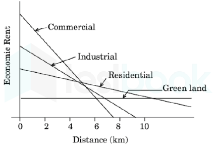
Which one of the following categories of urban land use as per given graph has the highest gradient of its economic rent at 2 km distance?

  1. AOption (a)

    Green land

  2. BOption (b)

    Residential

  3. COption (c)

    commercial

  4. DOption (d)

    Industrial

View answer & explanation

Correct answer

Answer: (c)C.

commercial

Why this answer is correct

Bid-Rent Theory:

  • In 1960 William Alonso completed his dissertation which extended the von Thünen model to urban land uses.
  • His model gives land use, rent, the intensity of land use, population, and employment as a function of distance to the CBD of the city as a solution of an economic equilibrium for the market for space.
  • The von Thünen model required considerable modification to apply to residential, commercial, and industrial land use.
  • In the von thünen model, the bid-rent function declined as a result of the increased transportation costs to transport the produce of one unit of land one additional unit of distance.

Important Points

  • A preliminary rationalization of a bid-rent function for a household came out of the Chicago Transportation Study.
  • There the results indicated that households behaved as though they had a combined rent and transportation budget such that if transportation costs were higher then the amount that they would pay for rent is lower.
  • A more sophisticated formulation assumes that households have preferences given by a set of indifference curves.
  • The bid-rent function is the amount that a household could pay for rent at different locations (with differing transportation costs) such that the same level of satisfaction is achieved; i.e., the household is on the same indifference curve.
  • This formulation allows for the possibility that different amounts of housing space could be chosen at different locations.
  • Also, it allows for the possibility that higher-income households end up locating in the suburbs because of the relative cost of open land space there compared with locations closer the CBD.
  • The bid-rent function would not have to be a straight line.
  • A shift to a higher bid-rent function for a household involves the acceptance of a lower indifference curve.
  • This could happen if a household found there was no location where its bid-rent function equaled or surpassed the market rent.
  • Bid-rent function theory may be formulated mathematically.

Key PointsThree concepts are at the core of the land rent theory:

Rent:

  • A surplus (profit) resulting from some advantages such as capitalization and accessibility.
  • It is based on the capability to pay and a function of economic activity.
  • The rent is usually the highest for retail because this activity is closely dependent upon accessibility to generate income.

Rent gradient:

  • A representation of the decline in rent with distance from a point of reference, usually the central business district.
  • This gradient is related to the marginal cost of distance for each activity, which is how distance influences its bidding rent.
  • The friction of distance has an important impact on the rent gradient because with no friction all locations would be perfect locations.

Bid rent curve function:

  • The combination of land prices and distances among which the individual (or firm) is indifferent.
  • It describes the price range that a household (or firm) would be willing to pay at various locations in order to achieve a given level of satisfaction (utility/ profits).
  • The activity that has the highest bid rent is theoretically the activity that will occupy this location.

In the above diagram, the commercial area has the highest gradient of its economic rent at 2 km distance.

Question 43

Given below are two statements, one is labelled as Assertion (A) and the other is labelled as Reason (R). Read the statements and choose the correct answer using the code given below.

Assertion (A) : Most transportation networks begin as branching networks.

Reason (R) : Because the first priority of the transport agencies that build them is generally to get all points connected.

  1. AOption (a)

    Both (A) and (R) are true and (R) is the correct explanation of (A).

  2. BOption (b)

    Both (A) and (R) are true, but (R) is not the correct explanation of (A).

  3. COption (c)

    (A) is true, but (R) is false.

  4. DOption (d)

    (A) is false, but (R) is true.

View answer & explanation

Correct answer

Answer: (b)B.

Both (A) and (R) are true, but (R) is not the correct explanation of (A).

Why this answer is correct

Key Points

 Assertion (A) :  Most transportation networks begin as branching networks.

  • A Transport network or transportation network refers to an integrated pattern in which routes of a group of centres also known as nodes (place of offloading and offloading of goods) are linked by routes.
  • A transport network is an overall system consisting of transport routes and modes.
  • Networks are connected through roads and streets, railways, pipes, aqueducts, and power lines.
  • The branching networks are most preferred by the builders.
  • Such a pattern provides the shortest route connecting all the nodes, while at the same time allowing all journeys to bypass intervening nodes.

Hence, the assertion is correct.

Reason (R): Because the first priority of the transport agencies that build them is generally to get all points connected.

  • The specific purpose of transportation is to fulfill a demand for mobility since transportation can only exist if it moves passengers, freight, and information around.
  • Good transport links can encourage businesses to locate nearer to one another and bring them closer to their supply chain and share expertise.
  • The increase in the concentration of business economies helps improve performance and increases productivity.
  • For this reason transport agencies more emphasis on making the branches of the network get connected with every point.

Hence, the reason is also correct but not a reason for the assertion.

Therefore, Both (A) and (R) are true, but (R) is not the correct explanation of (A).

Question 44

Which one of the following terms is generally used to express the relationship between cultural groups and their natural environment?

  1. AOption (a)

    Cultural ecology

  2. BOption (b)

    Cultural convergence

  3. COption (c)

    Cultural diffusion

  4. DOption (d)

    Cultural hearth

View answer & explanation

Correct answer

Answer: (a)A.

Cultural ecology

Why this answer is correct

The word "culture" derives from a French term, which in turn derives from the Latin "colere," which means to tend to the earth and grow, or cultivation and nurture.

Culture is the characteristics and knowledge of a particular group of people, encompassing language, religion, cuisine, social habits, music and arts.

"Culture encompasses religion, food, what we wear, how we wear it, our language, marriage, music, what we believe is right or wrong, how we sit at the table, how we greet visitors, how we behave with loved ones, and a million other things,"

  • Cultural ecology is a theoretical approach that attempts to explain similarities and differences in culture in relation to the environment. Cultural ecology is the study of the adaptation of a culture to a specific environment and how changes in that environment lead to changes in that specific culture.
  • It also focuses on how the overall environment, natural resources available, technology, and population density affect the rest of the culture and how a traditional system of beliefs and behavior allows people to adapt to their environment.
  • Cultural convergence is the theory that two cultures will be more and more like each other as their interactions increase. Basically, the more that cultures interact, the more that their values, ideologies, behaviors, arts, and customs will start to reflect each other.
  • Cultural diffusion describes the spread of one culture’s practices, beliefs, and/or items, like food, music, or tools. This spread can be among members of the same culture or to completely different cultures around the world. Cultural diffusion is why many cultures around the world share similarities.
  • A cultural hearth is a nuclear area within which an advanced and distinctive set of culture traits, ideas and technologies develops and from which there is diffusion of those characteristics and complexes.

Question 45

Which one of the following groups of states of India was ranked as top three States in proportion of Scheduled Tribes population to total population according to census 2011?

  1. AOption (a)

    Madhya Pradesh, Nagaland, Jharkhand

  2. BOption (b)

    Mizoram, Bihar, Rajasthan

  3. COption (c)

    Lakshadweep, Mizoram, Nagaland

  4. DOption (d)

    Nagaland, Rajasthan, Jharkhand

View answer & explanation

Correct answer

Answer: (c)C.

Lakshadweep, Mizoram, Nagaland

Why this answer is correct

  • As per Census 2011, the Maximum ratio of ST are in the following states:-
  • Mizoram - 94.8 Percent
  • Nagaland - 86.5 %
  • Meghalaya - 86.1 %
  • Arunachal Pradesh - 68. 8 %
  • Lakshadweep is the Union territory in which the ST Population is 94.8 % and it the highest in UTs.
  • ST is 8.6 per cent of the total population of India according to census 2011.
  • The decadal growth rate of the scheduled tribes was 23.7 per cent during the period 2001-2011.

Question 46

Match List 1 with List 2 and choose the correct answer form the code given below:

List 1 (Term)List 2 (Definition)
(a) Language1. Differences in vocabulary, pronunciation, rhythm and speed that set speakers of same languages apart from each other
(b) Dialects2. An organized system of spoken words, used to communicate with mutual understanding
(c) Vernacular3. Established language used for communication by people with mutually incomprehensible native tongue
(d) Lingua Franca4. Non-standard language or version of a language that is native to a local area
  1. AOption (a)

    (a) - 1, (b) - 2, (c) - 3, (d) - 4

  2. BOption (b)

    (a) - 2, (b) - 4, (c) - 1, (d) - 3

  3. COption (c)

    (a) - 4, (b) - 2, (c) - 1, (d) - 3

  4. DOption (d)

    (a) - 2, (b) - 1, (c) - 4, (d) - 3

View answer & explanation

Correct answer

Answer: (b)B.

(a) - 2, (b) - 4, (c) - 1, (d) - 3

Why this answer is correct

(Term)(Definition)
Language- A language is a method of human communication, either spoken or written, consisting of the use of words in a structured and conventional way.
Dialects- In terms of its dictionary definition, a dialect is ‘a particular form of a language which is peculiar to a specific region or social group.’ - This implies that we can view a language in the role of parent, with a range of dialects stemming from it.
Vernacular- The word vernacular originates from the Latin word, vernāculus, meaning native or indigenous. - Ideally, vernacular is the way ordinary people talk with each other in non-formal settings like at home. - A vernacular language (non-standard dialect) is a native dialect or form of speech of specific people or a specific region. - These languages are also known as ethnic languages, and they are more spoken than formally written and are endemic in specific societies.
Lingua Franca- A lingua franca (vehicular languages) is a language used when people speaking different vernacular dialects want to communicate with each other. - This language is also known as a bridge language, ‘language of the Franks,’ common language or a trade language because it provides a way for different ethnicities to communicate. - Vernacular language usually represents a community’s native language while a lingua franca often has a widespread use, beyond borders of the original community.

Question 47

Which one of the following transport network depicts : Vertices 6, Edges 6, Diameter 4?

  1. AOption (a)

    A

  2. BOption (b)

    B

  3. COption (c)

    C

  4. DOption (d)

    D

View answer & explanation

Correct answer

Answer: (a)A.

A

Why this answer is correct

Important Points

Network topology:

  • Graphs have some properties that are very useful when unraveling the information that they contain.
  • It is important to realize that the purpose of any type of network analysis is to work with the complexity of the network to extract meaningful information that you would not have if the individual components were examined separately.
  • Network properties, and particularly topological properties, can help us identify relevant sub-structures within a network.
  • Topology is the way in which the nodes and edges are arranged within a network.
  • Topological properties can apply to the network as a whole or to individual nodes and edges.

Key Points

  1. Nodes: The nodes represent different entities (e.g. proteins or genes in biological networks)
  2. Edges: The edges convey information about the links between the nodes.
  3. Diameters: The diameter of a graph is the maximum eccentricity of any vertex in the graph. That is, it is the greatest distance between any pair of vertices. The diameter of a network is defined as the longest path of the shortest path between any two nodes. For example, the diameter of a 4x4 mesh D = 6

Given,  Vertices 6, Edges 6, Diameter 4

Comparison:

DiagramElements
Vertices = 6 Edges = 6 Diameter = 4
Vertices = 6 Edges = 7 Diameter = 3
Vertices = 5 Edges = 6 Diameter = 2
Vertices = 6 Edges = 5 Diameter = 5

Hence, only the first image is true as per the given data in the question.

Question 48

Match List 1 with List 2 and choose the correct answer form the code given below:

List 1 (Cultural diffusion)List 2 (Definition)
(a) Relocative1.Upward/downward movement of dispersal through a system of classes or centres
(b) Hierarchical Diffusion2. When acceptance of or information about an innovation spreads throughout the society
(c) Expansion Diffusion3. When expansion affects almost uniformly to all individuals and areas from a source region
(d) Contagious Diffusion4. Geographical transfer of culture traits by movements of people across space
  1. AOption (a)

    (a) - 1, (b) - 2, (c) - 4, (d) - 3

  2. BOption (b)

    (a) - 3, (b) - 2, (c) - 1, (d) - 4

  3. COption (c)

    (a) - 2, (b) - 1, (c) - 4, (d) - 3

  4. DOption (d)

    (a) - 4, (b) - 1, (c) - 2, (d) - 3

View answer & explanation

Correct answer

Answer: (d)D.

(a) - 4, (b) - 1, (c) - 2, (d) - 3

Why this answer is correct

(Cultural diffusion)(Definition)
Relocative- It is the geographical transfer of culture traits by movements of people across space. - As the location continuously changes, this type of diffusion is coined relocation diffusion. - An example is the movement of a bush fire, which has burned out at the origin but continues to spread at the periphery. - Immigration from country to country, city to city, etc. - As they relocate to a new location, they bring their ideas, cultural tradition such as food, music, and more.
Hierarchical Diffusion- It is when an idea spreads by passing first among the most connected individuals, then spreading to other individuals. - Think of the chain of command in businesses, and the government. - There’s somewhat of a hierarchy in terms of position of authority. - Example- The Federal government such as the president, vice president, cabinet members are the first to be informed of governmental matters before the general public and state government employees.
Expansion Diffusion- Expansion diffusion is the spread of a factor or an innovation from a centre with the concentration of things being diffused throughout the society.
Contagious Diffusion- It is the expansion which affects all the individuals and areas uniformly from a source region. - The introduction of a new fashion trend which spreads like a wildfire through various social media sites can be cited as an example.

Question 49

Which one of the following subjects/functions is listed on the Concurrent List in India?

  1. AOption (a)

    Post and Telegraph

  2. BOption (b)

    Defence

  3. COption (c)

    Price Control

  4. DOption (d)

    Banking

View answer & explanation

Correct answer

Answer: (c)C.

Price Control

Why this answer is correct

In respect of matters on which both the Parliament and the state legislatures have the power of legislation (i.e., the subjects enumerated in the Concurrent List), the executive power rests with the states except when a Constitutional provision or a parliamentary law specifically confers it on the Centre.

Constitution confers executive power of a subject in the Concurrent List to the State Government.

Union List:

  • The Union List is a list of 100 (Originally 97) numbered items as provided in the Seventh Schedule to the Constitution of India. The Union Government or the Parliament of India has exclusive power to legislate on matters relating to these items.
  • Post and Telegraph, Defence and Banking

State List:

  • The State List is a list of 61 (Originally 66) items in the Schedule Seven to the Constitution of India.  The respective state governments have exclusive power to legislate on matters relating to these items.

Concurrent List:

  • There are 52 (Originally 47) items currently on the list: This includes items that are under the joint domain of the Union as well as the respective States. However, given that there can be conflict when it comes to laws passed by Parliament and state legislatures on the same subject, the Constitution provides for a central law to override state law.
  • Price Control comes under Concurrent List.

Question 50

The concept of Lebensraum gained popularity in the field of political geography following the publication of

  1. AOption (a)

    Geographical Pivot of HIstory

  2. BOption (b)

    Politische Geographic

  3. COption (c)

    Making Political Geography

  4. DOption (d)

    Foreign Affairs

View answer & explanation

Correct answer

Answer: (b)B.

Politische Geographic

Why this answer is correct

  • The monumental Politische Geographie (1897) is described as the 1st book on modern political geography by Friedrich Ratzel that is based on the organismic analogy, following which the concept of Lebensraum gained popularity.
  • The concept of Lebensraum states that all living organisms are involved in an endless struggle for space and the most powerful will have the largest space.

Question 51

The term 'Geopolitics' was coined by

  1. AOption (a)

    Haushofer

  2. BOption (b)

    Kjellen

  3. COption (c)

    Ratzel

  4. DOption (d)

    Mackinder

View answer & explanation

Correct answer

Answer: (b)B.

Kjellen

Why this answer is correct

  • The word geopolitics was originally coined by the Swedish political scientist Rudolf Kjellén about the turn of the 20th century, and its use spread throughout Europe in the period between World Wars I and II (1918–39) and came into worldwide use during the latter.
  • Geopolitics is a framework that we can use to understand the complex world around us. Global politics, or “getting what you want in the world” involves thinking and acting geographically.
  • Geopolitics explains how countries, businesses, terrorist groups, etc. try to reach their political goals by controlling geographic features of the world. We call these features geographical entities.
  • Geographical entities are the places, regions, territories, scales, and networks that make up the world. Geopolitics looks at a particular use of power: how countries and other groups compete to control these entities within the international community. Controlling these entities is seen to help countries and groups reach their goals.
  • Geopolitics is always looked at with an international and global dimension, meaning that the issues being looked at are connected to the global scale. Thus, geopolitics can be defined as the struggle over the control of geographical entities with an international and global dimension, and the use of such geographical entities for political advantage.

Question 52

Which one of the following is the most accurate representative of cultural unit form the highest to the lowest order?

  1. AOption (a)

    Complex, Realm, Region, Trait

  2. BOption (b)

    Realm, complex, Region, Trait

  3. COption (c)

    Realm, Region, Complex, Trait

  4. DOption (d)

    Trait, Complex, Region, Realm

View answer & explanation

Correct answer

Answer: (c)C.

Realm, Region, Complex, Trait

Why this answer is correct

Culture is the specialized behavioral social patterns, understandings, adaptations, and social systems that summarize a group of people’s learned way of life.

Key Points

Cultural unitDefinition
Cultural realm- It is the largest possible area of cultural influence. - It is a wider concept and includes overlaps and transitional areas. - It can be discontinuous. E.g. Islam realm.
Cultural region- It is a modern concept and does not include geographical continuation. - There should be a boundary; geopolitical regions have been used to define cultural regions. - Culture traits and complexes have an areal (spatial) extent. - Used to show the spatial extent of similar cultural areas. - Examples - Cajun Region
Cultural complex- It is a distinctive pattern of activities, beliefs, rites, and traditions associated with one central feature of life in a particular culture. - An example is the cluster of activities, ceremonies, folklore, songs, and stories associated with the hunting and use of the buffalo by Native American peoples. Also called culture pattern.
Cultural trait- Any basic belief, practice, technique, or object that can be said to identify a given culture in some aspect of its economic, political, social, or religious organization, such as a specific agricultural practice, law, ritual, belief about child-rearing, or architectural design. - Smallest item of culture-building block of culture. - Learned behavior ranging from the language spoken to tools to games. - They can be objects, techniques, beliefs, or attitudes.

Hence, the correct sequence in decreasing order is Realm, Region, Complex, Trait

Question 53

Who among the following geographers has authored the book 'The Geography of State Policies'?

  1. AOption (a)

    R. L. Morrill

  2. BOption (b)

    S. B. Cohen

  3. COption (c)

    Richard Hartshorne

  4. DOption (d)

    J. R. V. Prescott

View answer & explanation

Correct answer

Answer: (d)D.

J. R. V. Prescott

Why this answer is correct

John Robert Victor Prescott is the author of the book 'The Geography of State Policies'.

John Robert Victor Prescott:

  • John Robert Victor Prescott (12 May 1931 - 17 August 2018) FASSA was a British and Australian academic, author, and professor emeritus at the University of Melbourne.
  • A political geographer, most of Prescott's work focused on international boundary issues, particularly maritime boundaries.
  • He was interested in political geography, specifically focusses on borders and frontiers.
  • His other studies included Australian Aboriginal conceptions of territory and frontiers, border disputes in South East Asia and the South China Sea, and the effects of the colonial period on African borders.

The Geography of State Policies:

  • This book was published in 1968.
  • This book examines the reciprocal relationships between geography and the policies of states.
  • The text begins with a theoretical analysis which sets the study in the context of geography and related fields, and an analysis of certain global strategies advocated by geographers and others.

Hence, J. R. V. Prescott is the correct answer here.

Question 54

What percentage share of net tax revenue is now shared by the National Government of India with the States after the acceptance of the recommendations of XIV Finance Commission?

  1. AOption (a)

    32

  2. BOption (b)

    28

  3. COption (c)

    42

  4. DOption (d)

    50

View answer & explanation

Correct answer

Answer: (c)C.

42

Why this answer is correct

  • The 14th finance commission recommended increase in the share of states in the centre's tax revenue from the current 32% to 42%-the single largest increase ever recommended.
  • The recommendation, which the government will likely accept, will give more power to states in determining how they spend this money (it also correspondingly reduces the fiscal resources available to the centre).

Question 55

The following are two lists, one having the names of the planned towns and the other having the names of rivers on which they were planned. Match List 1 with List 2 and choose the correct answer from the code given below.

List 1 (Name of town)List 2 (Name of river)
(a) Ayodhya1. Yamuna
(b) Harappa2. Indus
(c) Shahjahanabad3. Saryu
(d) Mohenjo-daro4. Ravi
  1. AOption (a)

    (a) - 1, (b) - 2, (c) - 3, (d) - 4

  2. BOption (b)

    (a) - 2, (b) - 3, (c) - 4, (d) - 1

  3. COption (c)

    (a) - 3, (b) - 4, (c) - 1, (d) - 2

  4. DOption (d)

    (a) - 4, (b) - 1, (c) - 2, (d) - 3

View answer & explanation

Correct answer

Answer: (c)C.

(a) - 3, (b) - 4, (c) - 1, (d) - 2

Why this answer is correct

(Name of town)(Name of river)
Ayodhya- Ayodhya is situated on the banks of Sarayu river. - Sarayu river originates in Uttarakhand and flows through Uttar Pradesh. - This river is of ancient significance, finding mentions in the Vedas and the Ramayana. Hence statement 1 is correct. - It is a tributary of the Sharda River. - It flows through the Kumaon Himalayas.
Harappa- Harappa​ was situated on the banks of the river Ravi. - It was discovered first in 1921 at the modern site of Harappa situated in the province of West Punjab in Pakistan. - Harappan civilization is also known as Indus Valley Civilization for being situated on and around the banks of the Indus river. - It flourished around 2,500 BCE in the western part of South Asia, in contemporary Pakistan, western India, and parts of Afghanistan
Shahjahanabad- The access to river Yamuna for nobles was controlled by development architectural form in which the white marble mausoleum was placed on a terrace by the edge of the river and garden was to its south. - Thus Yamuna played an important role in the layout of the new Mughal city at Shahjahanabad.
Mohenjo-daro- Mohenjodaro is situated on the bank of the Indus river. - The Indus River is one of the main rivers of the Indo-Gangetic Plain in the Indian subcontinent. - It flows through the Indian state of Jammu & Kashmir and along the length of Pakistan to the Arabian Sea.

Question 56

Which one of the following indices is used to indicate if the optimal location was closer to either raw material source or the market?

  1. AOption (a)

    Material Index

  2. BOption (b)

    Weighted Index

  3. COption (c)

    Labour Cost Index

  4. DOption (d)

    Relative Spread Index

View answer & explanation

Correct answer

Answer: (a)A.

Material Index

Why this answer is correct

Material Index was devised by Alfred Weber to indicate if the optimal location was closer to either raw material source or the market.

The Material Index is part of the least cost location principle and defined as the ratio of the weight of localised materials used in the industry to the weight of the product.

The material index equals 1 when there is no weight loss in the production, while if the material index is higher than 1, there is substantial weight loss.

  • Material Index = Weight of localized materials/weight of the finished products.
  • If material index > 1 then the plant would be located near the sources of materials.
  • If material index < 1 then the plant would be located near to the market.

Question 57

Given below are two statements, one is labelled as Assertion (A) and the other is labelled as Reason (R). Read the statements and choose the correct answer using the code given below.

Assertion (A) : The decade of 1990s witnessed urbanisation process speeding up economic growth in India.

Reason (R) : The urbanisation process resulted in a growing shortage of urban services and an overall deterioration in the quality-of-urban-life indices.

  1. AOption (a)

    Both (A) and (R) are true and (R) is the correct explanation of (A).

  2. BOption (b)

    Both (A) and (R) are true, but (R) is not the correct explanation of (A).

  3. COption (c)

    (A) is true, but (R) is false.

  4. DOption (d)

    (A) is false, but (R) is true.

View answer & explanation

Correct answer

Answer: (b)B.

Both (A) and (R) are true, but (R) is not the correct explanation of (A).

Why this answer is correct

Assertion (A) : The decade of 1990s witnessed urbanisation process speeding up economic growth in India.

  • The post–1991 India witnessed a rapid growth in GDP on a continual basis for two decades. The growth of GDP increased from 5.6 per cent during 1980–91 to 8.2 per cent during 2007–12.
  • It was the year when Economic reforms were introduced in the year 1991 in India to combat the economic crisis.
  • The Government of India announced the New Economic Policy(NEP) in 1991
  • It was in this time period we witnessed urbanisation process speeding up economic growth in India.

Reason (R) : The urbanisation process resulted in a growing shortage of urban services and an overall deterioration in the quality-of-urban-life indices.

  • The process of urbanisation affects all sizes of settlements, villages gradually grow to become small towns, smaller towns become larger towns, and large towns become cities. This trend has led to the growth of mega-cities. A mega-city is an urban area of greater than ten million people. Rapid expansion of city borders, driven by increases in population and infrastructure development, leads to the expansion of city borders that spread out and swallow up neighbouring urban areas to form mega-cities. These things resulted into growing shortage of urban services and an overall deterioration in the quality-of-urban-life indices
  • However it is not the cause of speeding up of urbanization process and economic growth in India in 1990s.

Question 58

There are two lists, one having macro regions and another their meso regions. Match list 1 with List 2 and choose the correct answer form the code given below.

List 1 (Macro region)List 2 (Meso region)
(a) Central1. Damodar Valley
(b) Western2. Malnad
(c) Southern3. Saurashtra
(d) Eastern4. Bastar
  1. AOption (a)

    (a) - 1, (b) - 2, (c) - 3, (d) - 4

  2. BOption (b)

    (a) - 2, (b) - 3, (c) - 4, (d) - 1

  3. COption (c)

    (a) - 3, (b) - 4, (c) - 1, (d) - 2

  4. DOption (d)

    (a) - 4, (b) - 3, (c) - 2, (d) - 1

View answer & explanation

Correct answer

Answer: (d)D.

(a) - 4, (b) - 3, (c) - 2, (d) - 1

Why this answer is correct

Key Points 

List 1 (Macro region)List 2 (Meso region)
(a) Central4. Bastar
(b) Western3. Saurashtra
(c) Southern2. Malnad
(d) Eastern1. Damodar Valley

Hence, the correct matching is (a) - 4, (b) - 3, (c) - 2, (d) - 1

Important Points

Regional classification by The town and country planning organization:

  • The town and country planning organization suggested a scheme of planning region delineated on the principle of economic viability, self-sufficiency, and ecological balance at the macro and meso levels.
  • The emphasis of the scheme was to introduce regional factors in economic development.
  • The approach was aimed to complement the macro planning at the national level, with a component of regional policies, aimed at reducing regional disparities in the development.
  • The macro regionalization sought to link a set of areas, rich in one type of resources with areas having complementary resources or even resource-poor areas, so that the benefits of economic activity in the former may flow into the latter.
  • The scheme proposed 13 macro-regions which are further divided into 35 meso regions and 3 metropolitan areas
Macro regionMeso region
Central Peninsular region(Karnataka, Goa, Andhra Pradesh
Western Peninsular regionWestern Maharashtra – Coastal
South Peninsular regionKerala & Tamil Nadu
Eastern Peninsular regionOrissa, Jharkhand, NE A.P., Chhattisgarh

Question 59

Which one of the following kinds of towns was not planned and developed during the British Rule in India?

  1. AOption (a)

    Cantonment Towns

  2. BOption (b)

    Model Towns

  3. COption (c)

    Railway Colonies

  4. DOption (d)

    Hill Stations

View answer & explanation

Correct answer

Answer: (b)B.

Model Towns

Why this answer is correct

Cantonment Towns

  • The nature of the colonial city changed further in the mid-nineteenth century. After the Revolt of 1857 British attitudes in India were shaped by a constant fear of rebellion. They felt that towns needed to be better defended, and white people had to live in more secure and segregated enclaves, away from the threat of the “natives ”.
  • Pasturelands and agricultural fields around the older towns were cleared, and new urban spaces called “Civil Lines” were set up. White people began to live in the Civil Lines.
  • Cantonments– places where Indian troops under European command were stationed – were also developed as safe enclaves. These areas were separate from but attached to the Indian towns. With broad streets, bungalows set amidst large gardens, barracks, parade ground and church, they were meant as a safe haven for Europeans as well as a model of ordered urban life in contrast to the densely built up Indian towns.

Railway Colonies

  • The introduction of railways in 1853 meant a change in the fortunes of towns. Economic activity gradually shifted away from traditional towns which were located along old routes and rivers. Every railway station became a collection depot for raw materials and a distribution point for imported goods.
  • With the expansion of the railway network, railway workshops and railway colonies were established. Railway towns like Jamalpur, Waltair and Bareilly developed.

Hill Stations

  • As in the case of cantonments, hill stations were a distinctive feature of colonial urban development. The founding and settling of hill stations was initially connected with the needs of the British army.
  • Simla (present-day Shimla) was founded during the course of the Gurkha War (1815-16); the Anglo-Maratha War of 1818 led to British interest in Mount Abu; and Darjeeling was wrested from the rulers of Sikkim in 1835.
  • Hill stations became strategic places for billeting troops, guarding frontiers and launching campaigns against enemy rulers.

Question 60

Given below are two statements, one is labelled as Assertion (A) and the other is labelled as Reason (R). Read the statements and choose the correct answer using the code given below.

Assertion (A) : The city plans in ancient India were laid down in accordance to some pre-conceived ideas, with high standards of public health.

Reason (R) : This does not, however, reflect the concern of ancient India for community sanitation and health.

  1. AOption (a)

    Both (A) and (R) are true and (R) is the correct explanation of (A).

  2. BOption (b)

    Both (A) and (R) are true, but (R) is not the correct explanation of (A).

  3. COption (c)

    (A) is true, but (R) is false.

  4. DOption (d)

    (A) is false, but (R) is true

View answer & explanation

Correct answer

Answer: (c)C.

(A) is true, but (R) is false.

Why this answer is correct

Key Points

Assertion (A):  The city plans in ancient India were laid down in accordance with some preconceived ideas, with high standards of public health.

  • Hygiene is a very important part of life as it keeps each one of us healthy both physically and mentally.
  • Some people have a tendency to believe that modern man knows best and that our ancestors were unaware of the hygiene practices.
  • Ancient Indians took very much care to care for their skin, cleanliness, and hygiene has been imbibed into the Indian culture since the Harappa and Mohenjo-Daro times.
  • Cleanliness is equally important when it comes to food and its preparation.
  • One of the ancient civilizations of the world is Indus Valley Civilization in India.
  • The drainage system was one of the most remarkable features of Harappan city.

Hence, the assertion is correct.

Reason (R): This does not, however, reflect the concern of ancient India for community sanitation and health.

  • The overall purpose of the hygiene and sanitation program is to improve hygiene behaviors and encouraging effective community management of sanitation and water sources to reduce diseases.
  • Improved sanitation leads to lower disease burden, improved nutrition, reduced stunting, improved quality of life, increased attendance of girls at school, healthier living environments, better environmental stewardship, increased job opportunities and wages, improved competitiveness of cities, and economic and social environment.

Hence, that reason is incorrect.

Therefore, (A) is true, but (R) is false.

Question 61

Who among the following has classified Indian agriculture into sixty micro-regions, thirteen meso-regions and six macro-regions?

  1. AOption (a)

    Jasbir Singh

  2. BOption (b)

    L. Dudley Stamp

  3. COption (c)

    S. P. Chatterjee

  4. DOption (d)

    P. Sen-Gupta

View answer & explanation

Correct answer

Answer: (d)D.

P. Sen-Gupta

Why this answer is correct

P. Sengupta along with Galina Sdasyuk (1968) presented a three-tier classification of India's agricultural regions in the 'Economic Regionalization of India'.

  • (i) Climatic characteristics : 4 macro regions.
  • ii) Physiographic characteristics: 11 meso regions.
  • (iii) Crop combinations : 60 micro region

Question 62

Which of the following group of States recorded Santhal tribe population as per census of India, 2011?

  1. AOption (a)

    Bihar, Jharkhand, Maharashtra

  2. BOption (b)

    Gujarat, Bihar, Rajasthan

  3. COption (c)

    Jharkhand, Odisha, West Bengal

  4. DOption (d)

    Bihar, Odisha, Andhra Pradesh

View answer & explanation

Correct answer

Answer: (c)C.

Jharkhand, Odisha, West Bengal

Why this answer is correct

  • The Scheduled Tribe (ST) population of Jharkhand State is as per 2001 census constituting 26.3 per cent of the total population (26,945,829) of the State.
  • Among all Sates and UTs, Jharkhand holds 6th and 10th ranks terms of the ST population and the percentage share of the ST population to the total population of the State respectively.
  • The state has a total of thirty (30) Scheduled Tribes and all of them have been enumerated at 2001 census
  • Out of thirty (30) Scheduled Tribes notified for the State, Santhal is the most populous tribe constituting 34 per cent of the total ST population of the State.
  • The total population of West Bengal at 2001 Census has been 80,176,197.
  • Scheduled Tribes (STs) constituting 5.5 per cent of the total population of the state. There are total thirty eight (38) notified STs in the state. The Santal represents more than half of the total ST population of the state.
  • Hence, Jharkhand, Odisha, West Bengal States recorded Santhal tribe population as per census of India, 2011

Question 63

Match List 1 with List 2 and choose the correct answer form the code given below:

List 1 (Hydro Electric Power Plant)List 2 (States)
(a) Kopali1. Maharashtra
(b) Dool-Hasti2. Assam
(c) Koyna3. Jammu and Kashmir
(d) Ranganadi4. Arunachal Pradesh
  1. AOption (a)

    (a) - 1, (b) - 4, (c) - 3, (d) - 2

  2. BOption (b)

    (a) - 3, (b) - 2, (c) - 4, (d) - 1

  3. COption (c)

    (a) - 2, (b) - 3, (c) - 1, (d) - 4

  4. DOption (d)

    (a) - 4, (b) - 1, (c) - 2, (d) - 3

View answer & explanation

Correct answer

Answer: (c)C.

(a) - 2, (b) - 3, (c) - 1, (d) - 4

Why this answer is correct

(Hydro Electric Power Plant)(States)
Kopali- Located on the River Kopili in the Dima Hasao District of Assam, the Kopili Hydro Electric Project was the maiden venture of NEEPCO when it came into existence in 1976.
Dool-Hasti- Dul Hasti is a 390 MW hydroelectric power plant in Kishtwar district of Jammu and Kashmir, India built by NHPC. - The power plant is a run-of-the-river type on the Chenab River.
Koyna- The Koyna Hydroelectric Project is the second largest hydroelectric power plant in India, just after Tehri Dam Project. - It is a complex project with four dams including the largest dam on the Koyna River, Maharashtra. - The project site is in Satara district.
Ranganadi- This Project is located in the Lower Subansiri District of the State of Arunachal Pradesh in the Ranganadi basin and the adjoining Dikrong basin.

Question 64

Match List 1 with List 2 and choose the correct answer form the code given below:

List 1 (Soil Type)List 2 (States)
(a) Alluvial1. Kerala
(b) Red2. Uttarakhand
(c) Laterite3. Tamil Nadu
(d) Submontane4. Uttar Pradesh
  1. AOption (a)

    (a) - 1, (b) - 4, (c) - 3, (d) - 2

  2. BOption (b)

    (a) - 3, (b) - 2, (c) - 1, (d) - 4

  3. COption (c)

    (a) - 2, (b) - 3, (c) - 1, (d) - 4

  4. DOption (d)

    (a) - 4, (b) - 3, (c) - 1, (d) - 2

View answer & explanation

Correct answer

Answer: (d)D.

(a) - 4, (b) - 3, (c) - 1, (d) - 2

Why this answer is correct

(Soil Type)(States)
Alluvial- Gangetic plain of Uttar Pradesh has a flat topography and highly fertile alluvial soil. - Gangetic plain span about three-fourths of the total area of the state. - Alluvial soil has potash deficiency. - The colour of soil varies from light grey to ash. - Alluvial soil is suited for Rice, maize, wheat, sugarcane, etc.
Red- Red soils have originated from weathering of the ancient crystalline, and metamorphic rocks. - In comparison with regur (black soil), and iron oxide (Ferrous oxide). - Have a small capacity for absorption of moisture and retention of bases like potassium, calcium, and magnesium by an exchange. - Suitable in general for the cultivation of ragi, groundnut, millet, potato, tobacco, paddy, wheat, and sugarcane. Found in state of Tamil Nadu.
Laterite- Laterite soils are rich in oxides of iron and aluminum but deficient in nitrogen and potash. - As it is poor in nitrogen, it is not fertile and poor for agriculture - It is majorly found in higher areas of Peninsular Plateau especially in Kerala. - It is found as a result of decomposition due to heavy rainfall and high temperature.
Submontane- These soils are formed in high rainfall regions of sub- Himalayan under coniferous forests. - The soils are acidic in reaction. The organic matter accumulation is high and there is absence of free lime.

Question 65

Which one of the following is not a part of the Central Highlands?

  1. AOption (a)

    Maharashtra Plateau

  2. BOption (b)

    Malwa Plateau

  3. COption (c)

    Bundelkhand Plateau

  4. DOption (d)

    Chotanagpur Plateau

View answer & explanation

Correct answer

Answer: (a)A.

Maharashtra Plateau

Why this answer is correct

Key Points

  • The Peninsular plateau is a tableland composed of the old crystalline, igneous and metamorphic rocks.
  • It was formed due to the breaking and drifting of the Gondwana land and thus, making it a part of the oldest landmass.
  • The plateau has broad and shallow valleys and rounded hills.
  • This plateau consists of two broad divisions, namely, the Central Highlands and the Deccan Plateau.
  • The part of the Peninsular plateau lying to the north of the Narmada river, covering a major area of the Malwa plateau, is known as the Central Highlands.
  • The Vindhyan range is bounded by the Satpura range on the south and the Aravalis on the northwest. The further westward extension gradually merges with the sandy and rocky desert of Rajasthan. The flow of the rivers draining this region, namely the Chambal, the Sind, the Betwa, and the Ken is from southwest to northeast, thus indicating the slope.
  • The Central Highlands are wider in the west but narrower in the east. The eastward extensions of this plateau are locally known as the Bundelkhand and Baghelkhand.

Important PointsCentral highland is broadly classified into four plateaus namely

  1. Malwa plateau
  2. Bundelkhand plateau
  3. Bhagelkhand plateau
  4. Chotanagpur plateau.

Hence, the Malwa plateau is a part of the central highland and not comes under the southern part of it. Maharastra plateau is located in the western part, Chota Nagpur in the eastern part, and Vindhya is located in the southern portion of it.

Question 66

Which one of the following mapping techniques is correct to show delineated areas having different colours?

  1. AOption (a)

    Isopleth

  2. BOption (b)

    Choropleth

  3. COption (c)

    Chorochromatic

  4. DOption (d)

    Choroschematic

View answer & explanation

Correct answer

Answer: (c)C.

Chorochromatic

Why this answer is correct

Chorochromatic technique is best suited to show delineated areas having different colours.

  • It is also applicable in indicating political, cultural, ethnological distinctions between places usually made by shading each unit areas
  • Chorochromatic techniques imply the drawing of boundary lines to delimit specific areas within which shading or coloring is applied to mark distinctive features
  • Chorochromatic maps can be simple or compound
  • In simple chorochromatic maps, single features with patchy occurrence are depicted (e.g. distribution of forest resources or mining fields in a country)
  • Compound Chorochromatic maps show phenomena in which types and categories can be recognized.

Isopleth

  • Data are represented on some maps by lines each of which is inconsistent esteem. Accordingly, a line which joins places of equivalent value in regard to some distribution is generally called as ISOPLETH. It is a combination of Greek words ISOS-(means same) and Plethron-(means measure). Thus a line on a map joining points having the same amount of rainfall is an isopleth and is called as ISOHYET.
  • Similarly, an isopleth connecting places of equal temperature is called an Isotherm, Isobars for equal pressure, Isobath for equal depth, Isohaline for equal salinity etc.

Choropleth

  • It is employed to represent the variations in the distribution of average value per unit area within the geographical or administrative divisions by applying various cartographic shades.

It is a system of depicting the variations with the assistance of various shades or outlines which demonstrate very low, low, medium, high and very high estimations of the distribution of data. It is used to show various demographic features like the density of population, age-structure, sex-ratio, literacy levels etc.

Choroschematic

  • ​In this technique, the geographical phenomenon like soil, land use, vegetation etc. are depicted by various cartographic symbols like dots, circles, triangles, initial letters of the elements to represent on the map. This method mostly stresses on the location rather than the characteristics of the phenomenon. Neither the shape nor the color of the symbol used represents the dimension of the object. The main advantage of this method is that many elements may be shown together on a single map.

Question 67

During which one of the following Five Year Plans was regional approach to build new towns and prepare master and regional plans, emphasized in India for the first time?

  1. AOption (a)

    Fourth Five Year Plan

  2. BOption (b)

    Third Five Year Plan

  3. COption (c)

    Sixth Five Year Plan

  4. DOption (d)

    Ninth Five Year Plan

View answer & explanation

Correct answer

Answer: (b)B.

Third Five Year Plan

Why this answer is correct

Third Five Year Plan

  • The Third Five Year Plan has been the dawn of the regional development and had become a distinct policy of the government. This plan for the first time made a specific provision of around 30 million rupees for the preparation of comprehensive development plans for urban and regional development.
  • This also gave a strong impetus to the development of cities, towns, regions as well as planning for river valley regions and industrial regions.
  • In the Third Plan it will be essential to link up the programme more closely with different schemes of community development such as provision of water supply, roads, drainage, public health, education etc.
  • It is also necessary that rural housing activities should be effectively coordinated with other connected programmes of rural development so as to ensure that the villages selected under the village housing scheme derive the maximum benefit from the limited resources which are available.
  • The Third Plan provides for a programme of about Rs. 29 crores for slum clearance and improvement

Question 68

Which one of the following statements is true about the concept of development?

  1. AOption (a)

    Development is a discrete process.

  2. BOption (b)

    Development is a uni-dimensional process.

  3. COption (c)

    Development stands for growth with a change.

  4. DOption (d)

    Meaning of development remains the same in time and space.

View answer & explanation

Correct answer

Answer: (c)C.

Development stands for growth with a change.

Why this answer is correct

Key Points Characteristics of Development: 

  • Development is Interrelated: Growth and development always go hand in hand (in general) but development is also possible without growth as some people do not gain in size but do experience functional improvement or development in social, intellectual, or social aspects. This concept is known as the Principle of Interrelation. This Development always stands for Growth with change.
  • Development is Lifelong: This belief has two separate aspects. First, the potential for development extends across the entire life span: there is no assumption that the life course must reach a plateau or decline during adulthood and old age. Second, development may involve processes that are not present at birth but emerge throughout the life span.
  • Development is Multidimensional: Multidimensionality refers to the fact that development cannot be described by a single criterion such as increases or decreases in a behavior. It occurs in the biological, cognitive, and social-emotional domains.
  • Development is affected by cultural changes: An individual’s development is molded to conform to cultural standards and norms, while changes in these standards affect the developmental pattern.
  • Development is Contextual: Development varies across the different contexts in which we live our lives. For example, social and rural environments are associated with different sets of factors that have the potential to impact development; understanding how development differs for individuals within these two settings requires an understanding of the differing contexts. It occurs in the context of a person’s biological makeup, the physical environment, and social, historical, and cultural contexts.
  • Development is Multidirectional: The principle of multidirectional maintains that there is no single, normal path that development must or should take. In other words, healthy developmental outcomes are achieved in a wide variety of ways. Development is often comprised of multiple abilities that take different directions, showing different types of change or constancy.

Hence, from the above-mentioned characteristics of Development**, one could easily conclude that Development stands for growth with change.**

Question 69

Which one of the following rivers does not form a delta?

  1. AOption (a)

    Mahanadi

  2. BOption (b)

    Cauvery

  3. COption (c)

    Narmada

  4. DOption (d)

    Krishna

View answer & explanation

Correct answer

Answer: (c)C.

Narmada

Why this answer is correct

River narmada does not form a delta.

River Narmada:

  • The Narmada is the westward flowing river of Peninsular India.
  • Source: The Narmada rises from the western flank of Amarkantak plateau in the state of Madhya Pradesh.
  • Mouth: The Narmada river drains into the Gulf of Khambat (the Arabian Sea) near Bharuch in the state of Gujarat.
  • The river flows in a rift valley between the Vindhyas in the north and the Satpura in the south.
  • The river forms a picturesque gorge in marble rocks.
  • The Narmada forms the Dhaundhar waterfalls, southwest of Jabalpur.
  • It forms the traditional boundary between North India and South India.
  • Peninsular rivers, such as the Narmada and the Tapi form estuaries.

Most of the major rivers of the peninsula such as the Mahanadi, the Godavari, the Krishna and the Cauvery flow eastwards and drain into the Bay of Bengal. These rivers make deltas at their mouths. Hence, only Narmada from th elist does not form delta.

Question 70

Which one of the following variables is correct to divide a universe of 500 students of a class into two by their gender and then take a random sample of the males and a random sample of females?

  1. AOption (a)

    Control variable

  2. BOption (b)

    Independent variable

  3. COption (c)

    Dependent variable

  4. DOption (d)

    Stratified variable

View answer & explanation

Correct answer

Answer: (d)D.

Stratified variable

Why this answer is correct

  • Stratified sampling method is appropriate when the population has mixed characteristics, and you want to ensure that every characteristic is proportionally represented in the sample.
  • You divide the population into subgroups (called strata) based on the relevant characteristic (e.g. gender, age range, income bracket, job role).
  • Stratification divides all cases into groups, based on one or more variables, for the computation of expected values. The Empirica Signal application sums these expected values across all of the strata to provide a single expected value for all of the cases in the background.
  • Here according to the question, the Stratified variable is the correct option as in this variable the target population or in this case the universe of 500 students is divided into 2 stratums on the basis of homogenous characteristics and then from each of those sub-groups a simple random sample is collected. Hence, the correct option is 4th.

Question 71

For expediting the development of small and medium sized towns, the scheme of Integrated Development of Small and Medium Towns (IDMST) was initiated during the

  1. AOption (a)

    Fifth Five Year Plan

  2. BOption (b)

    Sixth Five Year Plan

  3. COption (c)

    Eighth Five Year Plan

  4. DOption (d)

    Ninth Five Year Plan

View answer & explanation

Correct answer

Answer: (b)B.

Sixth Five Year Plan

Why this answer is correct

Integrated Development of Small and Medium Towns (IDMST)

  • The Centrally-sponsored Scheme of Integrated Development of Small and Medium Towns (IDSMT) was initiated in the Sixth Plan (1979-80) and has continued in the Seventh and Eighth Plans.
  • Its main objective has been to slow down migration from rural areas end smaller towns to large cities by the development of selected small and medium towns which are capable of generating economic growth and employment.
  • Generally migration takes place from villages and towns to cities in search of employment and income opportunities. “Poverty-push” and “prosperity-pull” factors coupled with the expectations that cities offer diverse opportunities for jobs and better living conditions are primarily responsible for this.
  • The IDSMT Scheme; by strengthening small and medium towns as regional growth centres aims at reducing migration to large and metropolitan cities. Through the establishment of complementary, linkages between villages, towns and cities, it envisages a harmonious pattern of settlements.

The Objectives of the IDSMT Scheme are :

  • Improving infrastructural facilities and helping in the creation of durable public assets in small and medium towns having potential to emerge as regional centres of economic growth and employment, thereby reducing the incentives for people belonging lo rural and smaller urban areas to migrate to bigger cities and towns for jobs.
  • Decentralising economic growth and employment opportunities and promoting dispersed urbanisation while taking due advantage of the functional interlinkages between villages, towns and cities through a regional planning approach.
  • Increasing the availability of serviced sites for housing, commercial and industrial uses and promoting the principles of planned and orderly spatial development.
  • Integrating spatial and socio-economic planning as envisaged in the Constitution (74th Amendment),1992 and preparing and implementing Town/City Development Plans.
  • Promoting resource-generating schemes for the urban local bodies to improve their overall financial position and ability to undertake long-term infrastructure development programmes on their own as well, as to repay the borrowed capital and usher in necessary municipal reforms.

Question 72

The major objective behind identification of five counter-magnet cities outside the National Capital Region (NCR) was

  1. To further strengthen policies for decentralisation of economic activities within and outside the NCR.
  2. To further strengthen policies for decentralisation of population within and outside the NCR.
  3. To further strengthen the availability of physical infrastructure facilities within and outside the NCR.
  4. To further strengthen health and medical care service outside the NCR.

Choose the correct answer form the code given below:

  1. AOption (a)

    1 and 3 are correct.

  2. BOption (b)

    1, 2 and 4 are correct.

  3. COption (c)

    1 and 2 are correct.

  4. DOption (d)

    1, 3 and 4 are correct.

View answer & explanation

Correct answer

Answer: (c)C.

1 and 2 are correct.

Why this answer is correct

  • The National Capital Region (NCR) Planning Board came into being by virtue of the NCR Planning Board Act, 1985 passed by Parliament and duly confirmed by the legislatures of Haryana, Rajasthan and Uttar Pradesh.
  • The preamble of the said Act stipulates: “An Act to provide for the constitution of a Planning Board for the preparation of a plan for the development of the National Capital Region and for coordinating and monitoring the implementation of such plan...” The total area of the National Capital Region is 33,578 sq. kms. excluding the area of Counter Magnet Areas (CMAs).
  • The National Capital Territory of Delhi: is less than 4.5% of the NCR.
  • The major objective behind identification of five counter-magnet cities outside the National Capital Region (NCR) was to further strengthen policies for decentralisation of economic activities within and outside the NCR. And to further strengthen policies for decentralisation of population within and outside the NCR.
  • The basic objectives of the NCR regional plan and this was to be accomplished through checks on the location of large industries in Delhi and encourage the dispersal of industries and other job opportunities elsewhere in the NCR.
  • There was also a suggestion to decentralise the selected government offices by developing the transport network, water supply, power supply, housing, medical and educational facilities.

The administrative units of the National Capital Region are:

  • Union Territory of Delhi;
  • Uttar Pradesh Sub-Region comprises  Meerut, Ghaziabad, Gautam Bhudha Nagar, Bulandshahr and Baghpat districts;
  • Rajasthan Sub-Region comprises  the Alwar district; and
  • Haryana Sub-Region comprises  Faridabad, Gurgaon, Mewat, Rohtak, Sonepat, Rewari, Jhajjar and Panipat districts.

Question 73

Which one of the following is approximate length (in '000kms) of the Indian coastline?

  1. AOption (a)

    5

  2. BOption (b)

    6

  3. COption (c)

    7

  4. DOption (d)

    8

View answer & explanation

Correct answer

Answer: (c)C.

7

Why this answer is correct

Key PointsThe coastline of India:

  • The peninsular part of India extends towards the Indian Ocean.
  • This has provided the country with a coastline of 6,100 km on the mainland
  • The total length of the coastline of the mainland, Lakshadweep Islands, and Andaman & Nicobar Islands are 7,516.6 km.
  • India's coastline extends to Nine states (Gujarat, Maharashtra, Goa, Karnataka, Kerala, Tamil Nadu, Andhra Pradesh, Odisha, and West Bengal) and four Union Territories (Puducherry, Lakshadweep, Daman & Diu, and Andaman & Nicobar Islands).
  • Gujarat has the largest share (23%) in India’s coastline, followed by Andhra Pradesh and Tamil Nadu.


StateCoastline (in Km)
Gujarat1214.70
Andhra Pradesh973.70
Tamil Nadu906.70
Maharashtra652.60
Kerala569.70
Odisha476.70
Karnataka280
Goa101
Andaman and Nicobar1912

Hence, the Indian coastline extends up to 9 states, i.e. Gujarat, Maharashtra, Goa, Karnataka, Kerala, Tamil Nadu, Andhra Pradesh, Odisha, and West Bengal and its total length is 7,516.6 km.

Question 74

Which one of the following processes is the main task for the computer in mapping the geographical data?

  1. AOption (a)

    Data Storage

  2. BOption (b)

    Data collection

  3. COption (c)

    Data visualization

  4. DOption (d)

    Data retrieving and drawing

View answer & explanation

Correct answer

Answer: (d)D.

Data retrieving and drawing

Why this answer is correct

Data collecting, storing, retrieving, transforming and displaying spatial data from the real world are the main task for the computer in mapping the geographical data. Technology that provides the means to collect and use geographic data to assist in the development work is known as Geographical Information System (GIS).

  • A geographic information system (GIS) is a computer system for capturing, storing, checking, and displaying data related to positions on Earth’s surface. By relating seemingly unrelated data, GIS can help individuals and organizations better understand spatial patterns and relationships.
  • GIS technology is a crucial part of spatial data infrastructure, which the White House defines as “the technology, policies, standards, human resources, and related activities necessary to acquire, process, distribute, use, maintain, and preserve spatial data.”
  • GIS can use any information that includes location. The location can be expressed in many different ways, such as latitude and longitude, address, or ZIP code.
  • Many different types of information can be compared and contrasted using GIS. The system can include data about people, such as population, income, or education level. It can include information about the landscape, such as the location of streams, different kinds of vegetation, and different kinds of soil. It can include information about the sites of factories, farms, and schools, or storm drains, roads, and electric power lines.
  • With GIS technology, people can compare the locations of different things in order to discover how they relate to each other. For example, using GIS, a single map could include sites that produce pollution, such as factories, and sites that are sensitive to pollution, such as wetlands and rivers. Such a map would help people determine where water supplies are most at risk.

Question 75

Which one of the following States in India recorded the highest percentage of decadal growth of population during 2001 - 2011?

  1. AOption (a)

    Arunachal Pradesh

  2. BOption (b)

    Uttar Pradesh

  3. COption (c)

    Maharashtra

  4. DOption (d)

    West Bengal

View answer & explanation

Correct answer

Answer: (a)A.

Arunachal Pradesh

Why this answer is correct

The percentage of decadal growth of population during 2001-2011 as per Census 2011 is 17.64.

Decadal Growth Rate of Different Indian States are:

StateGrowth Rate(%)
Arunachal Pradesh26
Bihar25.4
Goa8.2
NCT of Delhi21.2

Additional Information

Decadal growth of population in the recent census:

  • As per Census 2011, the country’s Decadal Growth Rate was 17.7%.
  • India’s population in 2011 is estimated to be 1.21 billion, comprising 624 million males and 587 million females.
  • While the gender imbalance in the population remains, the preliminary census figures show that India’s female population grew by 18.12 per cent over the past decade against 17.19 per cent for males.
  • India’s population accounts for the world’s 17.5 per cent, second only to China that constitutes 19.4 per cent.
  • The country’s headcount is almost equal to the combined population of the United States, Indonesia, Brazil, Pakistan, Bangladesh and Japan, put together.
  • The population of India has increased by more than 181 million during 2001-11.
  • Uttar Pradesh is the most populous state with 199 million people and Lakshadweep the least populated at 64,429.

Question 76

Match List 1 with List 2 and choose the correct answer form the code given below:

List 1 (Biosphere Reserve)List 2 (States)
(a) Pachmarhi1. Assam
(b) Simlipal2. Madhya Pradesh
(c) Agasthyamalai3. Kerala
(d) Manas4. Odisha
  1. AOption (a)

    (a) - 3, (b) - 4, (c) - 1, (d) - 2

  2. BOption (b)

    (a) - 4, (b) - 2, (c) - 3, (d) - 1

  3. COption (c)

    (a) - 1, (b) - 3, (c) - 2, (d) - 4

  4. DOption (d)

    (a) - 2, (b) - 4, (c) - 3, (d) - 1

View answer & explanation

Correct answer

Answer: (d)D.

(a) - 2, (b) - 4, (c) - 3, (d) - 1

Why this answer is correct

(Biosphere Reserve)(States)
Pachmarhi- The Pachmarhi Biosphere Reserve is a biosphere reserve in the Satpura Range in Madhya Pradesh. - The conservation area was created in 1999 by the Indian government. - UNESCO designated it a biosphere reserve in 2009.
Simlipal- The government of India declared Simlipal as a biosphere in 1994. - This protected area is part of the UNESCO World Network of Biosphere Reserves since 2009. - Similipal National Park is a national park and a tiger reserve in the Mayurbhanj district in the Indian state of Odisha
Agasthyamalai- It is situated at the southern-most end of the Western Ghats and spread over two southern states Kerala and Tamil Nadu. - It was established in 2001. - It is named after Agastya Mala peak. - In March 2016, it was included in the World Network of Biosphere Reserves of UNESCO.
Manas- Manas Wildlife Sanctuary is located in the state of Assam. - The Manas Wildlife Sanctuary was tagged as World Heritage Site in 1985. - Manas is famous for its population of the Wild water buffalo

Question 77

Which one of the following features creates problems in the Satellite Remote Sensing data?

  1. AOption (a)

    Land cover

  2. BOption (b)

    Cloud cover

  3. COption (c)

    Water cover

  4. DOption (d)

    Vegetation cover

View answer & explanation

Correct answer

Answer: (b)B.

Cloud cover

Why this answer is correct

  • Remote sensing is the acquiring of information from a distance. Remote sensors, which provide a global perspective and a wealth of data about Earth systems, enable data-informed decision making based on the current and future state of our planet.
  • With the development of remote sensing from space, satellite data offers the possibility for measuring land surface temperature over the entire globe with sufficiently high temporal resolution and with complete spatially averaged rather than point values.
  • It is also possible to measure chlorophyll content in the vegetation of a specific location as chlorophyll will reflect more light in the green and near infrared spectrum compared to other wavelengths.
  • Remote sensing from satellites can also deliver information on green house gas(GHGs) soil emissions by estimating tropospherical, near-surface CO2 and CH4 concentrations based on the measurement of the intensity of the reflected sunlight in small wavelength bands in the visible and short-wavelength IR portion of the spectrum.
  • Remote sensing has emerged as a major tool in studying and analyzing the complex water resource systems.
  • However, whilst the efficiency of the response can be hampered when cloud cover limits image availability.

Question 78

Which one of the following is not a major industrial centre?

  1. AOption (a)

    Coimbatore

  2. BOption (b)

    Kolkata

  3. COption (c)

    Madurai

  4. DOption (d)

    Mumbai

View answer & explanation

Correct answer

Answer: (c)C.

Madurai

Why this answer is correct

  • Coimbatore is among the most industrially developed and commercially vibrant districts in Tamil Nadu.
  • The region’s industrial economy is largely driven by textiles, textile machinery, auto components, steel and aluminium foundries, pumps and motors, gold and diamond jewellery, educational institutions and information technology (IT).
  • Once hailed as the ‘Manchester of the South’, Coimbatore houses a large number of small and medium textile mills.
  • The term “Coimbatore Wet Grinder” was given a Geographical indication for wet grinders manufactured in Coimbatore and Erode. Coimbatore is home to a common facility for the manufacturers of wet grinders. Pump manufacturing, It is also called as the Pump City of India. The city also houses numerous jewellers engaged in jewellery exports. Major Wind Energy Company’s are located in and around Coimbatore.
  • Kolkata is the centre of India’s large jute-processing industry. The jute industry was established in the 1870s, and mills now extend north and south of the city centre on both banks of the Hugli River.
  • Engineering constitutes the city’s other major industry. In addition, city factories produce and distribute a variety of consumer goods—notably foodstuffs, beverages, tobacco, and textiles—other light manufactures, and chemicals.
  • Mumbai, with cotton hinterland and moist climate favoured the location of cotton textile industry. Hydro-electricity was developed in the Western Ghats region to meet the requirements of this industry. With the development of cotton textile industry, chemical industry also developed.
  • Important industrial centres are Mumbai, Kolaba, Kalyan, Thane, Trombay, Pune, Pimpri, Nashik, Manmad, Solapur, Kolhapur, Ahmednagar, Satara and Sangli.

Question 79

Variable Y regresses with variable X with the conditions that X‾=5.50\overline X = 5.50, Y‾=3.50\overline Y = 3.50 and b = 1.50 in the linear regression model (Y = a + bX), where Y‾\overline Y and X‾\overline X are means of the respective variables and b refers to gradient of line of Y w. r. t X. Which one of the following values of parameter 'a' of the model is correct?

  1. AOption (a)

    1.75

  2. BOption (b)

    3.75

  3. COption (c)

    -4.75

  4. DOption (d)

    -5.75

View answer & explanation

Correct answer

Answer: (c)C.

-4.75

Why this answer is correct

Important Points Linear regression analysis:

  • Linear regression analysis is used to predict the value of a variable based on the value of another variable.
  • The variable you want to predict is called the dependent variable.
  • The variable you are using to predict the other variable's value is called the independent variable.
  • This form of analysis estimates the coefficients of the linear equation, involving one or more independent variables that best predict the value of the dependent variable.
  • Linear regression fits a straight line or surface that minimizes the discrepancies between predicted and actual output values.
  • There are simple linear regression calculators that use a “least squares” method to discover the best-fit line for a set of paired data.
  • You then estimate the value of X (dependent variable) from Y (independent variable).

Shortcut Trick

 X‾=5.50\overline X = 5.50, 

Y‾=3.50\overline Y = 3.50 

b = 1.50 

(Y = a + bX)

Putting the values in the equation, 

3.50 = a + (1.50*5.50)

or, 3.50 = a + 8.25

or, a = -4.75

Hence, the value of 'a' of the model is -4.75

Question 80

Given below are two statements, one is labelled as Assertion (A) and the other is labelled as Reason (R). Read the statements and choose the correct answer using the code given below.

Assertion (A) : Nearest neighbour analysis is an approach to the study of point, line and area partners.

Reason (R) : Measurement of distance by comparing the observed mean distances with the expected mean distances between sampled points and their nearest neighbours.

  1. AOption (a)

    Both (A) and (R) are true and (R) is the correct explanation of (A).

  2. BOption (b)

    Both (A) and (R) are true, but (R) is not the correct explanation of (A).

  3. COption (c)

    (A) is true, but (R) is false.

  4. DOption (d)

    (A) is false, but (R) is true.

View answer & explanation

Correct answer

Answer: (a)A.

Both (A) and (R) are true and (R) is the correct explanation of (A).

Why this answer is correct

Key Points

Assertion (A):  Nearest neighbor analysis is an approach to the study of point, line, and area partners.

Nearest neighbor statistic: 

  • Nearest Neighbor Analysis measures the spread or distribution of something over geographical space.
  • It provides a numerical value that describes the extent to which a set of points are clustered or uniformly spaced.
  • This command uses the Clark and Evans (1954) aggregation index R as the basis for a crude test of clustering or order of a point pattern with the help of point, line, and area.

Hence, the assertion is correct.

Reason (R): Measurement of distance by comparing the observed mean distances with the expected mean distances between sampled points and their nearest neighbors.

  • The Rn value determines the randomness of the given settlements.
  • For this two things are requires, Area (a) and the length between settlements.
  • The formula is, Rn=Dˉ(Obs)0.5an\rm Rn = \dfrac{\bar{D}(Obs)}{0.5 \sqrt{\dfrac{a}{n}}}
  • Where, a = total area, n  = number of settlement, D = mean distance

Hence, the reason is also correct.

Important Points

Analysis of the question:

SettlementPatternCharacteristics
A)RandomSettlements are distributed in a dispersed manner
B)UniformSettlements are located in an equidistant pattern
C)ClusteredA compact form of the settlements, very closer to each other
D)More clustered than uniformSome settlements are situated in a compact form and some are uniformly distributed

Therefore, both (A) and (R) are true and (R) is the correct explanation of (A).

Question 81

Which one of the following diagrams represents the occupational structure of population?

  1. AOption (a)

    Isoleth

  2. BOption (b)

    Contour

  3. COption (c)

    Pie diagram

  4. DOption (d)

    Choropleth

View answer & explanation

Correct answer

Answer: (c)C.

Pie diagram

Why this answer is correct

The pie diagram represents the occupational structure of the population.

Pie diagram:

  • Pie diagrams are useful for showing a particular amount in relation to the whole as:

  • pie slices are proportional to the fraction of the whole in each category.

  • pie slices are used to illustrate relative sizes of data or numerical proportions.

  • pie slices are helpful to show a comparison between the most and least popular items.

  • pie slices accurately showing how each item of data contributes to the complete picture.

  • It could be concluded that pie diagrams are useful for showing a particular amount in relation to the whole.

  • For example, the diagram below showing various occupations of people of aregion.

  • Isopleth: Isopleth maps simplify information about a region by showing areas with continuous distribution.

  • Contour: A Contour line is an imaginary outline of the terrain obtained by joining its points of equal elevation

  • Choropleth: Choropleth maps are popular thematic maps used to represent statistical data through various shading patterns or symbols on predetermined geographic areas (i.e. countries).

Question 82

Which one of the following aspects could be correctly represented in a contour map?

  1. AOption (a)

    Population distribution

  2. BOption (b)

    Terrain elevation

  3. COption (c)

    Rock hardness

  4. DOption (d)

    Soil distribution

View answer & explanation

Correct answer

Answer: (b)B.

Terrain elevation

Why this answer is correct

Terrain elevation could be correctly represented in a contour map.

Contour:

Line joining points of the same elevation are called contour lines.

Contour Interval:

  • The elevation difference between two consecutive contours is called contour interval.
  • It is always kept the same or constant for a map.

Horizontal equivalent:

The horizontal distance between two consecutive contours is called equivalent.

Important Points

  • If contours are parallel and spacing between them is also constant then it shows a uniform slope.

  • Closely spaced contour represents a steep slope and distant contours represent generally mild slope.

  • Closed contours (loop) represent either a hill or a pond.

  • For a hill, readings increase toward the center and for a pond, it decreases toward the center.

  • Ridgeline/valley line intersect contour at a right angle. (Line joining topmost point of a hill is called Ridgeline and the line joining bottom-most points of a valley is called Valley line.)

  • Two contours of different elevation neither touch nor cross each other. (Exception: Vertical cliff & Overhanging cliff)

​

Hence, population distribution, rock hardness, or soil distribution are not shown using contour, it is suitable for terrain elevation and slope.

Question 83

Which one of the following denotes the lines joining equal amount of travel time?

  1. AOption (a)

    Isohaline

  2. BOption (b)

    Isochrone

  3. COption (c)

    Isoheight

  4. DOption (d)

    Isopleth

View answer & explanation

Correct answer

Answer: (b)B.

Isochrone

Why this answer is correct

Isochrone map denotes the lines joining an equal amount of travel time.

Key PointsIsochrone:

  • An isochrone (iso = equal, chrone = time) is defined as "a line drawn on a map connecting points at which something occurs or arrives at the same time".
  • Early examples of Isochrone maps include the Galton´s Isochronic Postal Charts and Isochronic Passage Charts of 1881 and 1882
  • An isochrone shows points of an equal value joined together.
  • It's most commonly used to depict travel times, such as drawing a 30 minute travel time perimeter around a start location.
  • The isochrone below joins up all points within a 45-minute drive from the origin.
  • It is a type of Isarithmic map.
  • An Isarithmic map is a type of Thematic map that represents a continuous field using line and/or region symbols to connect places of similar value.

Additional Information

  • Isohaline: Isohalines are lines (or contours) that join points of equal salinity in an aquatic system.
  • Isoheight: An isoheight or isohypse is a line of constant geopotential height on a constant pressure surface chart.
  • Isopleth: Isopleth maps simplify information about a region by showing areas with continuous distribution.

Question 84

Which one of the following random sampling techniques become more appropriate for homogeneous population groups?

  1. AOption (a)

    Systematic

  2. BOption (b)

    Simple

  3. COption (c)

    Stratified

  4. DOption (d)

    Proportionate

View answer & explanation

Correct answer

Answer: (b)B.

Simple

Why this answer is correct

Simple random sampling techniques become more appropriate for homogeneous population groups.

Sampling is a statistical procedure that is concerned with the selection of certain individual observations from the target population. It helps to make statistical inferences about the population.

There are two types of sampling

  1. Probability sampling
  2. Nonprobability sampling

Simple random sampling:

  • Simple random sampling is a type of probability sampling.
  • It is a sampling procedure where each element in the population will have an equal chance of being selected in the sample.
  • This process is simple because it requires only one stage of the sample selection process.
  • Here we number each frame unit from 1 to N.
  • Then use a random number table or a random number generator to select n distinct numbers between 1 and N, inclusively.
  • It is easier to perform for small populations but cumbersome for large populations.
Sampling techniqueMethod
Systematic sampling- It is convenient and relatively easy to measure. - Here an initial starting point is selected by a random process; then every nth number on the list is selected.
Stratified sampling- Here the population is divided into non-overlapping subpopulations called strata. - A random sample is selected from each stratum. - Each stratum is then sampled as an independent sub-population, out of which individual elements can be randomly selected. - Every unit in a stratum has the same chance of being selected.
Proportionate sampling- It is a type of stratified sampling - The percentage of the sample taken from each stratum is proportionate to the percentage that each stratum is within the population.

Question 85

Conrad discontinuity is found between

  1. AOption (a)

    Outer and Inner core

  2. BOption (b)

    Sial and Sima

  3. COption (c)

    Sima and Nife

  4. DOption (d)

    Upper mantle and Lower Mantle

View answer & explanation

Correct answer

Answer: (b)B.

Sial and Sima

Why this answer is correct

Conrad discontinuity is found between Sial and Sima.

Key Points

  • The border at which the density of SIAL and SIMA changes is known as Conrad discontinuity.
  • SIAL indicates the composition of Silica and Aluminium whereas SIMA indicates the composition of Silica and Magnesium.
  • A boundary within the Earth's continental crust that can be detected seismically at about 10–12 km depth
  • The exploratory deep drilling has failed to locate it.
  • The boundary separates the crust into a lower, basic layer and an upper, granitic layer.
<br>

Important PointsSeismic Discontinuities: Seismic discontinuities aid in distinguishing divisions of the Earth into the inner core, outer core, lower mantle, upper mantle, and crust.

  • Conrad discontinuity refers to the zone between the upper crust and lower crust.
  • Mohorovic discontinuity also called Moho discontinuity is the zone that separates the Earth's crust from the upper mantle. It can be detected by a sharp increase downward in the speed of earthquake waves there.
  • Repiti discontinuity refers to the zone between the upper mantle and lower mantle.
  • Gutenberg discontinuity refers to the zone separating the lower mantle from the core. It is located at a depth of about 2,900 km.
  • Lehmann discontinuity refers to the zone separating the solid inner core from the liquid outer core.

Question 86

Match List 1 with List 2 and choose the correct answer from the code given below:

List 1 (Name of Author)List 2 (Name of Book)
(a) Steers1. Geomorphology
(b) Von Ricthofen2. The Unstable Earth
(c) Wooldridge3. Principles of Geomorphology
(d) Thornbury4. Spirit and Purpose of Geography
  1. AOption (a)

    (a) - 3, (b) - 2, (c) - 1, (d) - 4

  2. BOption (b)

    (a) - 2, (b) - 1, (c) - 4, (d) - 3

  3. COption (c)

    (a) - 4, (b) - 3, (c) - 3, (d) - 1

  4. DOption (d)

    (a) - 1, (b) - 4, (c) - 3, (d) - 2

View answer & explanation

Correct answer

Answer: (b)B.

(a) - 2, (b) - 1, (c) - 4, (d) - 3

Why this answer is correct

Name of AuthorName of Book
SteersThe Unstable Earth
Von RicthofenGeomorphology
WooldridgeSpirit and Purpose of Geography
ThornburyPrinciples of Geomorphology

Hence, the correct matching is (a) - 2, (b) - 1, (c) - 4, (d) - 3

  1. J. A Steers: James Alfred Steers was a geographer and conservationist
  2. Von Ricthofen: He was a German traveler, geographer, and scientist. He is noted for coining the terms "Seidenstraße" and "Seidenstraßen" = "Silk Road(s)" or "Silk Route(s)" in 1877.
  3. Wooldridge: Professor Sidney William Wooldridge was a  geologist, geomorphologist and geographer, was a pioneer in the study of the geomorphology of south-east England and the first professor of geography at King's College London.

Question 87

Which part of the electromagnetic spectrum (EMS) causes human skin cancer?

  1. AOption (a)

    Gamma rays

  2. BOption (b)

    Ultraviolet radiation

  3. COption (c)

    micro waves

  4. DOption (d)

    Radio waves

View answer & explanation

Correct answer

Answer: (b)B.

Ultraviolet radiation

Why this answer is correct

The electromagnetic spectrum is a continuum of all electromagnetic waves arranged according to frequency and wavelength. The electromagnetic spectrum includes, from longest wavelength to shortest: radio waves, microwaves, infrared, optical, ultraviolet, X-rays, and gamma-rays. Among these waves, Ultraviolet radiation causes human skin cancer.

Ultraviolet radiation:

  • UV radiation is part of the natural energy produced by the sun.
  • On the electromagnetic spectrum, UV light has shorter wavelengths than visible light, so your eyes can’t see UV, but your skin can feel it.
  • Tanning beds also emit UV radiation.
  • Two types of UV light are proven to contribute to the risk for skin cancer:
  • Ultraviolet A (UVA) has a longer wavelength and is associated with skin aging.
  • Ultraviolet B (UVB) has a shorter wavelength and is associated with skin burning.
  • While UVA and UVB rays differ in how they affect the skin, they both do harm.
  • Unprotected exposure to UVA and UVB damages the DNA in skin cells, producing genetic defects, or mutations, that can lead to skin cancer (as well as premature aging.)
  • These rays can also cause eye damage, including cataracts and eyelid cancers.

Hence, Ultraviolet radiation is the correct answer.

Question 88

Which one of the following is required calories of heat to increase temperature by 10º C for 1 gram of water?

  1. AOption (a)

    1 calorie

  2. BOption (b)

    10 calories

  3. COption (c)

    32 calories

  4. DOption (d)

    5 calories

View answer & explanation

Correct answer

Answer: (b)B.

10 calories

Why this answer is correct

Key PointsThe concept of Calory:

  • Calorie, abbr. cal, a unit of heat energy in the metric system.
  • The measurement of heat is called calorimetry.
  • The calorie, or gram calorie, is the quantity of heat required to raise the temperature of 1 gram of pure water 1°C.
  • The kilocalorie, or kilogram calorie, is the quantity of heat required to raise the temperature of 1 kg of pure water 1°C; it is equal to 1,000 cal.
  • The kilocalorie is used in dietetics for stating the heat content of a food, i.e., the amount of heat energy that the food can yield as it passes through the body; in this context, the kilocalorie is usually called simply the calorie.
  • The amount of heat energy needed to effect a 1°C temperature increase in 1 gram of water varies with temperature (see heat capacity); thus the temperature range over which the heating takes place must be stated to define the calorie precisely.
  • The 15° calorie, or normal calorie, is widely used in chemistry and physics; it is measured by heating a 1-gram water sample from 14.5°C to 15.5°C at 1-atmosphere pressure.
  • The 4° calorie, also called the small calorie or therm, is measured from 3.5°C to 4.5°C (water is most dense at 3.98°C); the large calorie, or Calorie, is equivalent to 1,000 small calories.
  • The average value of the calorie in the range 0°C to 100°C is called the mean calorie; it is  1⁄100 of the energy needed to heat 1 gram of water from its melting point to its boiling point.
  • The calorie may also be defined by expressing its value in some other energy units.

Hence, 10 calories is required calories of heat to increase the temperature by 10º C for 1 gram of water

Question 89

Given below are two statements, one is labeled as Assertion (A) and the other is labeled as Reason (R). Read the statements and choose the correct answer using the code given below.

Assertion (A): During an equinox, the length of daylight is 12 hours everywhere on the Earth.

Reason (R): The circle of illumination passes directly through the poles, thus dividing the lines of latitude in the middle.

  1. AOption (a)

    Both (A) and (R) are true and (R) is the correct explanation of (A).

  2. BOption (b)

    Both (A) and (R) are true, but (R) is not the correct explanation of (A).

  3. COption (c)

    (A) is true, but (R) is false.

  4. DOption (d)

    (A) is false, but (R) is true.

View answer & explanation

Correct answer

Answer: (a)A.

Both (A) and (R) are true and (R) is the correct explanation of (A).

Why this answer is correct

As the Earth revolves around the sun throughout the year, different parts receive varying amounts of heat. The part (pole) which is more tilted towards the sun experiences longer days and a hotter climate during that period. As different parts of Earth are tilted towards the sun throughout the year while revolution, solstices, and equinoxes are experienced.

Key PointsAssertion (A): During an equinox, the length of daylight is 12 hours everywhere on the Earth.

Equinox:

  • An equinox is the instant of time when the plane of Earth's equator passes through the geometric center of the Sun's disk.
  • Equinox refers to a day with an equal duration of day and night.
  • We have two equinoxes in a year which are:
  • Spring equinox on March 20
  • Autumnal equinox on September 22.
  • It is the moment at which the center of the visible Sun is directly above the equator.
  • In the Northern Hemisphere, the March equinox is called the vernal or spring equinox while the September equinox is called the autumnal or fall equinox.
  • In the Southern Hemisphere, the reverse is true.
  • The equinoxes are the only times when the edge between night and day is perpendicular to the equator.
  • As a result, the northern and southern hemispheres are equally illuminated.
  • This is also the time when the Sun rises for an observer at one of Earth's rotational poles and sets at the other; for a brief period, both North and South Poles are in daylight.

Hence, the assertion is correct.

Reason (R): The circle of illumination passes directly through the poles, thus dividing the lines of latitude in the middle.

Circle of illumination:

  • The imaginary line which divides the parts of the earth with day and night is called the circle of illumination.
  • The circle of illumination is at a right angle to the orbital plane.
  • Thus, the circle of illumination is at an angle of 23.5º to the earth’s axis.
  • It divided the equator into two equal halves.
  • Because of the angle between the circle of illumination and the axis; both the hemispheres of the earth do not get the same amount of light on most of the days.
  • This causes different seasons at different times of the year.


  • The circle of illumination cuts all latitudes into half on the spring and autumnal equinoxes.
  • The circle of illumination bisects the equator while the circle of illumination separates light from darkness and day from night, the axis is a line along which the earth rotates.

Hence, the reason is also correct.

Therefore, both (A) and (R) are true and (R) is the correct explanation of (A).

Question 90

Given below are two statements, one is labelled as Assertion (A) and the other is labelled as Reason (R). Read the statements and choose the correct answer using the code given below.

Assertion (A) : Evaporation from water bodies is greater than that of land surfaces.

Reason (R) : Energy is not required to evaporate water.

  1. AOption (a)

    Both (A) and (R) are true and (R) is the correct explanation of (A).

  2. BOption (b)

    Both (A) and (R) are true, but (R) is not the correct explanation of (A).

  3. COption (c)

    (A) is true, but (R) is false.

  4. DOption (d)

    (A) is false, but (R) is true.

View answer & explanation

Correct answer

Answer: (c)C.

(A) is true, but (R) is false.

Why this answer is correct

Evaporation happens when a liquid turns into a gas. It can be easily visualized when rain puddles “disappear” on a hot day or when wet clothes dry in the sun. In these examples, the liquid water is not actually vanishing—it is evaporating into a gas, called water vapor.

Key Points Assertion (A):  Evaporation from water bodies is greater than that of land surfaces.

The surface of evaporation:

  • Evaporation of water into the atmosphere occurs from land, the oceans, and other water surfaces.
  • Evaporation increases as the surface area increases. It is because evaporation is a surface phenomenon.
  • The factors that affect the rate of evaporation of liquids are temperature, surface area, wind speed, and humidity.
  • Due to the open surface of the ocean, evaporation is greater than the land surface

Hence, the assertion is correct.

Reason (R): Energy is not required to evaporate water.

Mechanism of evaporation:

  • For evaporation to take place the presence of water inflow is assumed.
  • Water will evaporate from free open surfaces like land, lakes, reservoirs, open streams, but also from soils covered with vegetation, trees, etc.
  • Precipitation that reaches the ground surface returns to the atmosphere in vapor shape.
  • Natural evaporation is an energy-exchange process.
  • Energy input is necessary for evaporation to proceed.
  • The quantity of energy necessary to start the transition from a liquid state to a vapor state is called vapourization latent heat

The energy required for the process of evaporation. Hence, the reason is also correct.

Therefore, (A) is true, but (R) is false.

Question 91

Given below are two statements, one is labelled as Assertion (A) and the other is labelled as Reason (R). Read the statements and choose the correct answer using the code given below.

Assertion (A) : Low moisture content in air leads to the formation of towering storm clouds.

Reason (R) : The energy transfer form equator to poles takes place through evaporation and condensation.

  1. AOption (a)

    Both (A) and (R) are true and (R) is the correct explanation of (A).

  2. BOption (b)

    Both (A) and (R) are true, but (R) is not the correct explanation of (A).

  3. COption (c)

    (A) is true, but (R) is false.

  4. DOption (d)

    (A) is false, but (R) is true.

View answer & explanation

Correct answer

Answer: (d)D.

(A) is false, but (R) is true.

Why this answer is correct

Key Points

Assertion (A) : Low moisture content in air leads to the formation of towering storm clouds.Cloud formation:

  • Clouds are formed when the air contains as much water vapor (gas) as it can hold.
  • This is called the saturation point, and it can be reached in two ways.
  • First, moisture accumulates until it reaches the maximum amount the volume of air can hold.
  • The other method reduces the temperature of the moisture-filled air, which in turn lowers the amount of moisture it can contain.
  • Saturation, therefore, is reached through evaporation and condensation, respectively.
  • When saturation occurs, moisture becomes visible water droplets in the form of fog and clouds.

Hence, the assertion is incorrect.

Reason (R): The energy transfer from the equator to the poles takes place through evaporation and condensation.

Energy transfer from the equator to the poles:

  • The energy is transferred from the Earth's surface to the atmosphere by conduction and convection.
  • This energy is then moved from the tropics to the poles by advection, creating atmospheric circulation.
  • As a result, atmospheric circulation moves warm tropical air to the polar regions and cold air from the poles to the equator.
  • Latent heat flux moves energy globally when solid and liquid water is converted into vapor.
  • This vapor is often moved by atmospheric circulation vertically and horizontally to cooler locations where it is condensed as rain or is deposited as snow releasing the heat energy stored within it.
  • Finally, large quantities of radiation energy are transferred into the Earth's tropical oceans.
  • The energy enters these water bodies at the surface when absorbed radiation is converted into heat energy.

Hence, the reason is correct.

Therefore, (A) is false, but (R) is true.

Question 92

Identify the correct sequence of cloud formation in ascending order.

  1. AOption (a)

    Cumulus, Stratus, Cirrostratus, Altocumulus

  2. BOption (b)

    Altocumulus, Stratus, Cumulus, Cirrostratus

  3. COption (c)

    Stratus, Cumulus, Altocumulus, Cirrostratus

  4. DOption (d)

    Cumulus, Stratus, Atrocumulus, Cirrostratus

View answer & explanation

Correct answer

Answer: (c)C.

Stratus, Cumulus, Altocumulus, Cirrostratus

Why this answer is correct

  • When air rises, it gets cooled by expansion.
  • After reaching dew points, the condensation of the water vapour forms clouds.

Key PointsAccording to their height, expanse, density and transparency or opaqueness, clouds are grouped under four types: 

Cirrus:

  • Cirrus clouds are formed at high altitudes of 8,000 - 12,000 m.
  • They are thin and detached clouds having a feathery appearance.
  • They are always white.
  • They signify fair weather.

Cumulus:

  • They are generally formed at a height of 4,000 - 7,000 m.
  • Cumulus clouds look like cotton wool.
  • They exist in patches and can be seen scattered here and there.

Stratus:

  • As their name implies, these are layered clouds covering large portions of the sky.
  • These clouds are generally formed either due to loss of heat or the mixing of air masses with different temperatures.
  • They occur in the middle levels of the atmosphere.

Nimbus:

  • Nimbus clouds are black or dark grey.
  • They form at middle levels or very near to the surface.

​Thus, the types of clouds in the increasing order of their heights are Nimbus, Stratus, Cumulus and Cirrus.

Additional InformationA combination of these four basic types can give rise to the following types of clouds:

High cloudsAbove 6000 to 8000 meters from sea level.
CirrusThe wispy, fibrous-looking cloud indicates fair weather.
CirrocumulusA thin cloud, often globular and rippled
CirrostratusThin white sheet type which gives the sun and moon their haloes.
Medium clouds2000 to 6000 meters above sea level.
AltocumulusGlobular, bumpy looking clouds with a flat base covering the entire sky.
Altostratusgreyish, watery looking and a woolpack cloud.
Low cloudsBelow 2000 meters above sea level.
StratocumulusLow rolling and grey colour, bumpy clouds.
NimbostratusFog-like low' cloud causes dull weather with drizzle. It is also associated with lightning thunder and hailstorm.
StratusThese clouds are low, grey and layered, almost fog-like in appearance, bring dull weather and are often accompanied by drizzle air or snowfall.
Clouds of great Vertical extent1500 to 9000 meters above sea level.
CumulonimbusCumulus cloud which reaches up to 9000 meters, often indicates convectional rain, lightning and thunderstorm.

Question 93

Which one of the following groups of topographical features is the product of erosional process?

  1. AOption (a)

    Eskers, Fiords, V-shaped valley, Seifs

  2. BOption (b)

    Cirque, Arete, Playa, Stack

  3. COption (c)

    Moraine, Barchan, Pinnacle, Wave-built platform

  4. DOption (d)

    Levees, Stalagmites, Monodnocks, Drumlins

View answer & explanation

Correct answer

Answer: (b)B.

Cirque, Arete, Playa, Stack

Why this answer is correct

Cirque, Arete, Playa, Stack are erosional features by various geomorphic agents.

Topographic featureFormation and characteristics
Cirque- Cirques are bowl-shaped, amphitheater-like depressions that glaciers carve into mountains and valley sidewalls at high elevations. - 'Cirque' is a land-form generally formed by glaciers due to glacial erosion or sometimes by fluvial erosion.
Arete- Arete is a thin, jagged crest that separates or that once separated two adjacent glaciers. - These rugged ridgelines often look like serrated knives or saw blades, with steep sides and a sharp crest. - The low points on the serated surface are known as cols.
Playa- Playa Lakes are dry lakebeds located in arid basins or valleys. - In general, they form when water evaporates from a lake. - As the water evaporates, it leaves behind minerals, which are called evaporites.
Stack- A stack or sea stack is a geological landform consisting of a steep and often vertical column or columns of rock in the sea near a coast, formed by wave erosion. - Stacks are formed over time by wind and water, processes of coastal geomorphology.
  • Eskers, and Seifs are depositional landforms while the V-shaped valley and Fiords are erosional features.
  • Moraine, Barchan, Wave-built platforms are depositional features while Pinnacle is only an erosional feature.
  • Levees, Stalagmites, and Drumlins are depositional landforms but Monodnocks is an erosional feature found at the old stage of the cycle of erosion.

Question 94

Given below are two statements, one is labelled as Assertion (A) and the other is labelled as Reason (R). Read the statements and choose the correct answer using the code given below.

Assertion (A) : Plate margins and volcanic zones are closely related with each other.

Reason (R ) : Most of the volcanic zones are located along convergent plate boundaries.

  1. AOption (a)

    Both (A) and (R) are true and (R) is the correct explanation of (A).

  2. BOption (b)

    Both (A) and (R) are true, but (R) is not the correct explanation of (A).

  3. COption (c)

    (A) is true, but (R) is false.

  4. DOption (d)

    (A) is false, but (R) is true.

View answer & explanation

Correct answer

Answer: (a)A.

Both (A) and (R) are true and (R) is the correct explanation of (A).

Why this answer is correct

he rigid lithospheric slabs moving over the asthenosphere are known as the plates. The location where two plates meet is called a plate boundary. There are three kinds of plate tectonic boundaries: divergent, convergent, and transform plate boundaries. 

Convergent boundaries - 

  • When two plates come together, it is known as a Convergent boundary.
  • This boundary has two or more Lithospheric plates.
  • Some of the natural disasters that occurred due to the convergent boundary process are the 2004 Indian ocean earthquake and Tsunami and the 2011 Tsunami off the coast of Japan.

Divergent boundaries - 

  • When two tectonic plates move away from each other, it is known as a divergent boundary.
  • This boundary is also called a constructive boundary and extensional boundary.
  • Some of the examples of divergent boundaries are the Mid-Atlantic Ridge, Red sea Rift, and Explorer Ridge.

Transform boundaries - 

  • Two plates sliding past each other form a transform plate boundary.

  • These boundaries are also known as conservative plate boundaries.

  • Some of the examples of transform boundary are Pakistan's Chaman fault, Turkey's North Anatolian Fault, and Myanmar's Sagaing fault.

  • Convergent plate margins are characterized by the explosive type of eruption while divergent and conservative plate margins associated with the fissure type of eruption.

  • 80% of the volcanos are located along the subduction zone along the destructive plate mrgins.

Hence, both (A) and (R) are true and (R) is the correct explanation of (A).

Plate boundaryAssociated features
Convergent boundaries- Explosive type of volcanic eruption - Deep focus earthquake - Formation of folded mountains - Festoons, islands, oceanic trenches, etc. - After the name of scientist Hugo Benioff, the  zone of collision of two convergent plates is known as the Benioff zone or subduction zone
Divergent boundaries- Fissure flow of volcanic materials - Shallow focus earthquake - Drifting of the oceanic plate - Creation of new oceanic crust - Formation submarine mountain ridge and rises
Transform boundaries- This causes intense earthquakes, the formation of thin linear valleys, and split river beds. - The most famous example of a transform boundary is the San Andreas Fault in California.

Question 95

Which one of the following is responsible for Global Change in the sea-level?

  1. AOption (a)

    Isotatic

  2. BOption (b)

    Climatic

  3. COption (c)

    Eustatic

  4. DOption (d)

    Diastrophic

View answer & explanation

Correct answer

Answer: (c)C.

Eustatic

Why this answer is correct

Sea level change has been a feature on Earth for billions of years, and it has important implications for coastal processes, estuaries, and both erosional and depositional features.

Eustatic Changes:

  • Eustatic sea-level changes are global sea-level changes related to changes in the volume of water in the ocean.
  • These can be due to changes in the volume of glacial ice on land, thermal expansion of the water, or to changes in the shape of the seafloor caused by plate tectonic processes.
  • For example, seafloor spreading widens an ocean basin, thus changing its volume and affecting sea level.
  • Over the past 20,000 years, there have been approximately 125 m of eustatic sea-level rise due to glacial melting.
  • Most of that took place between 15,000 and 7,500 years ago during the major melting phase of the North American and Eurasian Ice Sheets.
  • At around 7,500 years ago, the rate of glacial melting and sea level rise decreased dramatically, and since that time, the average rate has been in the order of 0.7 mm/year.

Hence, eustatic changes are responsible for Global Change in the sea level.

  1. Isotactic changes: Isostatic sea-level changes are local changes caused by subsidence or uplift of the crust related either to changes in the amount of ice on the land or to the growth or erosion of mountains.
  2. Diastrophism is the process of deformation of the Earth's crust which involves folding and faulting. Diastrophism can be considered part of geotectonic.

Question 96

The Two-Cycle Theory on the origin of limestone caverns was proposed by

  1. AOption (a)

    Swinerton

  2. BOption (b)

    Davis

  3. COption (c)

    Malott

  4. DOption (d)

    Gardner

View answer & explanation

Correct answer

Answer: (b)B.

Davis

Why this answer is correct

Two-Cycle Theory on the origin of limestone caverns:

  • This dominant view for the formation of limestone caverns was challenged by W.M. Davis in his paper ‘Origin of Limestone Caverns’, published in 1930.
  • Davis instead proposed his two-cycle theory as the alternative, hr discussed
  • Limestone caverns are formed by the action of water below the water table instead of above.
  • This takes place by the action of water in two stages or cycles.
  • In the first cycle, phreatic water forms a solution for the dissolving processes that form a major part of the development of subterranean caverns.
  • Phreatic water is water from the phreatic zone i.e. the area below the water table in an aquifer where all the pores and fractures in the soil are saturated with water.
  • Davis proposed that this process in karst topographies is followed by the second cycle
  • A lowering of the level of the water table that leads to the draining of these areas,
  • leaving behind vacant spaces that form subterranean caverns.
  • These vacant spaces are often occupied by air and vadose water i.e. water at atmospheric pressure above the water table that is moving downward depending on gravitational forces

Hence, the Two-Cycle Theory on the origin of limestone caverns was proposed by Davis.

Question 97

Which of the following features is formed due to tectonic forces?

  1. AOption (a)

    Hanging valley

  2. BOption (b)

    U-shaped valley

  3. COption (c)

    Blind valley

  4. DOption (d)

    Rift valley

View answer & explanation

Correct answer

Answer: (d)D.

Rift valley

Why this answer is correct

Rift valley is formed due to tectonic forces.

Rift Valley system

  • Tension causes the central portion to be let down between two adjacent fault blocks forming a graben or rift valley, which will have steep walls.
  • The East African Rift Valley system is the best example.
  • In general, large-scale block mountains and rift valleys are due to tension rather than compression.
  • A rift valley is a lowland region that forms where Earth’s tectonic plates move apart or rift.
  • Rift valleys are found both on land and at the bottom of the ocean and are created by the process of seafloor spreading.
  • Rift valleys differ from river valleys and glacial valleys in that they are created by tectonic activity and not the process of erosion.
  • The Great Rift Valley System which stretches from the Middle East in the north to Mozambique in the south is a geologically active area.
  • It features volcanoes, hot springs, geysers, and frequent earthquakes.

Block Mountains

  • Block mountains may originate when the middle block moves downward or the side blocks move upward.

  • A rift valley forms while the surrounding blocks stand higher as block mountains.

  • U-shaped valley and Hanging valley: Glaciers form U-shaped valleys through erosion. Hanging Valleys are found high up on the sides of larger U-shaped valleys.

  • Blind valley: The Blind valley is found in the karst region. Karst topography is a geological formation shaped by the dissolution of a layer or layers of soluble bedrock, usually, carbonate rock such as limestone or dolomite, but also in gypsum.

Question 98

The upper part of the mantle upon which the crust of the Earth floats is known as

  1. AOption (a)

    Barysphere

  2. BOption (b)

    Mesosphere

  3. COption (c)

    Hydrosphere

  4. DOption (d)

    Asthenosphere

View answer & explanation

Correct answer

Answer: (d)D.

Asthenosphere

Why this answer is correct

The upper part of the mantle upon which the crust of the Earth floats is known as the Asthenosphere.

There are three layers of the earth, Crust, Mantle, and Core. The asthenosphere is the upper part of the Mantle.

Asthenosphere:

  • The asthenosphere is the denser, weaker layer beneath the lithospheric mantle.
  • It lies between about 100 kilometers (62 miles) and 410 kilometers (255 miles) beneath Earth's surface.
  • The temperature and pressure of the asthenosphere are so high that rocks soften and partly melt, becoming semi-molten.
  • The asthenosphere is generally more viscous than the lithosphere, and the lithosphere-asthenosphere boundary (LAB) is the point where geologists and rheologists, scientists who study the flow of matter mark the difference in ductility between the two layers of the upper mantle.

So, it is clear that the asthenosphere is located beneath the crust and the crustal plates are moving over this layer.

Barysphere: 

  • The inner most layer of the earth is called the “Core or Barysphere”.
  • It is otherwise known as NIFE, because of the presence of Nickel and Ferrous (iron).
  • This layer produces earth's magnetic field.

Mesosphere: 

  • The mesosphere is a layer of Earth's atmosphere.
  • The mesosphere is directly above the stratosphere and below the thermosphere.
  • It extends from about 50 to 85 km (31 to 53 miles) above our planet.
  • Temperature decreases with height throughout the mesosphere.

Hydrosphere: 

  • The definition of hydrosphere is made up of all the water and watery layers of the Earth.
  • All of the oceans, lakes, seas and clouds are an example of the hydrosphere.

Question 99

Geologically, the oldest rocks in India are from

  1. AOption (a)

    Dharwar region of Karnataka

  2. BOption (b)

    Aravali region of Rajasthan

  3. COption (c)

    Vindhyan region of Madhya Pradesh

  4. DOption (d)

    Siwalik region of Punjab

View answer & explanation

Correct answer

Answer: (a)A.

Dharwar region of Karnataka

Why this answer is correct

Dharwar rock formation:

  • The Dharwar system is later than the Archean system but older than the other system.
  • The bedrock in this region formed between 3.6 and 2.5 billion years ago.
  • It is responsible for the formation of the first sedimentary and metamorphic rock in India.
  • This is widespread in the Dharwar region of Karnataka and took its name from there.
  • The Dharwar Craton lies roughly between Chennai, Goa, Hyderabad, and Mangalore in the Karnataka and Andhra Pradesh states.
  • The oldest sedimentary rocks are found here.
  • The rocks do not contain fossils because eat the time of origin of this rock there as no species.

Hence, Geologically, the oldest rocks in India are from the Dharwar region of Karnataka.

  • The Aravali region of Rajasthan has formed nearly 1.8 million years ago.
  • Vindhyan region of Madhya Pradesh formed 1.6 to 1.7 billion years ago
  • Shiwaliks were formed last of all the ranges 2-20 million years ago.

Question 100

Which of the following groups of scholars stressed on the role of lateral erosion by streams in the formation of pediments?

  1. AOption (a)

    McGee, Paige, Blackwelder

  2. BOption (b)

    McGee, Blackwelder, Johnson

  3. COption (c)

    Paige, Johnson, Lawson

  4. DOption (d)

    Paige, Blackwelder, Johnson

View answer & explanation

Correct answer

Answer: (d)D.

Paige, Blackwelder, Johnson

Why this answer is correct

Lateral Erosion Theory:

  • G.K. Gilbert attrib­uted the formation of pediments to lateral corrasion by streams.
  • Later on S. Paige (1912), Eliot Black-welder (1931), D.W. Johnson (1932), Berkey, Morris, etc. also advocated for lateral erosion by streams as a powerful mechanism of pediment formation.

According to Johnson,

There are three zones alog the mountain,

  1. Inner zone
  2. Outer zone
  3. Intermediate zone

Explanation:

  • The inner zone represents the mountain front where down-cutting (ver­tical erosion) by streams is most active.
  • This zone is, thus, a zone of degradation.
  • The outer zone represents the lower segment which extends up to the margin of the intermontane basin (playa).
  • In fact, this zone is charac­terized by deposition to form bajada.
  • This zone, thus, is the zone of aggradation.
  • The intermediate zone represents the zone between the degradational zone (inner zone) and the aggradational zone (outer zone) where lateral erosion is most active.
  • This zone is also called a zone of pedimentation.
  • Rock fans are formed in the intermediate zone due to lateral erosion by the steams.
  • These rock fans gradually extend to become pediments.

Hence, Paige, Blackwelder, and Johnson stressed the role of lateral erosion by streams in the formation of pediments.

Sheet flood theory by McGee:

  • According to W.J. McGee (1897) pediments are formed due to erosion of weathered bedrocks by sheet-floods origi­nating from occasional torrential rainfall in deserts.
  • The eroded materials are transported downslope and are deposited as bajadas.
  • The advocates of this concept do not attach any importance to lateral erosion in the development of pediments because, according to them, the concave surface of pediments cannot be formed by lateral erosion.
  • The critics maintain that sheet-floods may have an ancillary influence on pediments once they are formed but they cannot initiate the formation of pediments.

100 questions in the full paper