Previous Year Paper

UGC NET Paper 2: Geography 12 Oct 2022 Shift 2 (Previous Year Paper)

Held in 2022

100 questions120 minutes
With answers
Free

Paper last updated:

Practise under exam conditions

Take this paper as a timed mock test. Review your answers after you submit.

Attempt timed test

Questions & answers

Read the paper at your pace. Open an explanation when you need it.

Question 1

Which of the following is colrect about the Raster data model in GIS?

(A) Raster data model is a simple data structure

(B) All pixels are of same size and shape

(C) Smaller file size

(D) Raster data model is compatible with remote sensing imageries

(E) Difficult overlay operations

Choose the correct answer from the options given below:

  1. AOption (a)

    (A), (B) and (D) only

  2. BOption (b)

    (A) and (C) only

  3. COption (c)

    (C) and (E) only

  4. DOption (d)

    (A), (B) and (E) only

View answer & explanation

Correct answer

Answer: (a)A.

(A), (B) and (D) only

Why this answer is correct

The correct option is (A), (B), and (D) only.

Important Points

(A) Raster data model is a simple data structure: True,

  • the raster data model stores data as a grid of cells,
  • where each cell is assigned a single value that represents an attribute such as elevation, temperature, etc.
  • This makes it a simple and easy-to-understand data structure.

(B) All pixels are of the same size and shape: True

  • in a raster data model, each cell or pixel has the same size and shape.
  • This allows for regular sampling and makes it easier to perform calculations and manipulations on the data.

(C) Smaller file size: False,

  • the file size of a raster data model depends on the number of cells and the resolution of the data.
  • In some cases, a raster data model can be smaller in file size than a vector data model, but in other cases, the opposite may be true.

(D) Raster data model is compatible with remote sensing imageries: True,

  • the raster data model is widely used in remote sensing as it can efficiently store the gridded data obtained from remote sensing imageries, such as satellite and aerial imagery.
  • The regular grid structure of raster data makes it well-suited for storing and processing image data.

(E) Difficult overlay operations: False,

  • overlay operations can be performed easily in a raster data model as it stores data as a grid of cells with single values.
  • Overlay operations involve combining two or more maps or data sets based on their spatial attributes, and this can be easily achieved in a raster data model by performing operations on the values in the cells of the grid.

Additional Information

Spatial data, in the context of geographic information systems (GIS), refers to data that contains information about the location, shape, and characteristics of geographic features and their relationships with one another. It includes both vector and raster data.

  1. Vector data: Represent geographic features as points, lines, or polygon shapes and store the spatial location, and attribute information about those features.
  2. Raster data: Represent geographic features as a grid of cells and store the values of each cell as attributes, such as elevation or land-use type.

Some common types of spatial data include:

  • Points: Represent discrete locations, such as cities or buildings.
  • Lines: Represent linear features, such as roads or rivers.
  • Polygons: Represent area features, such as land parcels or political boundaries.
  • Raster: Represent continuous surfaces, such as elevation, land cover, or satellite imagery.

These data types can be used in GIS to create maps and perform spatial analysis, such as calculating distances and areas, finding patterns and relationships, and making decisions based on geographic information.
Question 2

Which of the following statement is/are correct?

(A) Denudation involves weathering, mass wasting and erosion

(B) Physical Weathering and Mechanical Weathering process differ only in scale

(C) In dry climates, salt-crystal growth and weathering lead to the formation of distinctive hollowed-out near the bases of sandstone cliff

(D) Exfoliation occurs when temperature changes cause minerals to expand and contract at different rates

Choose the correct answer from the options given below:

  1. AOption (a)

    (B) only

  2. BOption (b)

    (A) and (C) only

  3. COption (c)

    (B) and (D) only

  4. DOption (d)

    (A) only

View answer & explanation

Correct answer

Answer: (b)B.

(A) and (C) only

Why this answer is correct

The correct code is A and C only.

Key Points

  • Denudation involves weathering, mass wasting, and erosion. This statement is correct.
  • Denudation is a geological process involving the wearing away of the Earth's surface by weathering, mass wasting, and erosion.
  • Weathering refers to the breakdown of rocks in situ due to various chemical, physical, and biological processes.
  • Mass wasting is the movement of rock and soil down slopes under the influence of gravity.
  • Erosion involves the removal and transportation of solids (sediment, soil, rock) by natural agents such as wind, water, and ice.
  • In dry climates, salt-crystal growth and weathering lead to the formation of distinctive hollowed-out areas near the bases of sandstone cliffs. This statement is correct.
  • Salt-crystal growth occurs when saline water seeps into rocks, evaporates, and leaves behind salt crystals, which expand and exert pressure on the rock.
  • This process, known as salt weathering, is particularly effective in dry climates where evaporation rates are high.
  • The persistent growth of salt crystals can lead to the formation of small niches and hollowed-out areas, often observed near the bases of sandstone cliffs.

Additional Information

  • Physical Weathering and Mechanical Weathering process differ only in scale.
  • This statement is incorrect.
  • Physical weathering and mechanical weathering are terms that are generally used interchangeably in geology, both referring to the physical breakdown of rocks without changing their chemical composition.
  • Therefore, the distinction stated in the question is not accurate as these processes do not differ in scale, but rather they are synonymous.

Question 3

Given below are two statements: one is labeled as Assertion A and the other is labeled as Reason R

Assertion (A): In terrestrial ecosystems (grassland, forests) the pyramid of biomass is upright with broad base

Reasons (R): In terrestrial ecosystems the biomass increases from primary to tertiary consumers

In the light of the above statements. choose the most appropriate answer from the options given below:

  1. AOption (a)

    Both (A) and (R) are correct and R is the correct explanation of A

  2. BOption (b)

    Both (A) and (R) are correct and R is NOT the correct explanation of A

  3. COption (c)

    (A) is correct but (R) is not correct

  4. DOption (d)

    (A) is not correct but (R) is correct

View answer & explanation

Correct answer

Answer: (c)C.

(A) is correct but (R) is not correct

Why this answer is correct

The correct answer is (A) is correct but (R) is not correct

Key Points 

Assertion (A) states that in terrestrial ecosystems, the pyramid of biomass is upright with a broad base.

  • This means that there is a large amount of biomass at the base of the pyramid, which represents the primary producers (plants).
  • Upward Pyramid In the majority of terrestrial ecosystems, the biomass pyramid has a large base of primary producers and a lower trophic level on top.
  • Autotrophic producer biomass is at an all-time high.

The reason (R) states that in terrestrial ecosystems, the biomass decreases from primary to tertiary consumers.

  • The biomass decreases as we move up the pyramid toward the tertiary consumers (top predators).
  • Although individual organisms tend to be larger in size at higher trophic levels, their smaller numbers result in less biomass at higher levels.
  • Biomass is the amount of organic matter present in an individual organism or in all the organisms at a given trophic level.

Therefore, the most appropriate answer is (A) is correct but (R) is not correct

Important Points 

Ecological pyramids

  • A graphical representation of the biomass or bio-productivity at each trophic level in a particular ecosystem is known as an ecological pyramid.
  • The base of a pyramid is broad and it narrows towards the apex.
  • This, relationship is expressed in terms of number, biomass, or energy.
  • The base of each pyramid represents the producers or the first trophic level while the apex represents the tertiary or top-level consumers.
  • The three types of ecological pyramids that are usually studied are (a) pyramid of number; (b) pyramid of biomass and (c) pyramid of energy.

 Additional Information

Pyramid of numbers:

  • This pyramid shows the number of individuals at each trophic level in an ecosystem.
  • For example, in a grassland ecosystem, there may be thousands of blades of grass, but only a few herbivores, and even fewer carnivores.
  • The pyramid of numbers would reflect the bottom (plants) and the smallest number at the top (top predators).

Pyramid of biomass:

  • This pyramid shows the total mass of living organisms at each trophic level in an ecosystem.
  • Like the pyramid of numbers, the pyramid of biomass also has the largest mass at the bottom (plants) and the smallest mass at the top (top predators).
  • However, because carnivores are often much larger than herbivores, the pyramid of biomass may not look exactly like the pyramid of numbers.

 Pyramid of energy:

  • This pyramid shows the amount of energy available at each trophic level in an ecosystem.
  • Energy is lost as it moves from one trophic level to the next, so the pyramid of energy has the largest amount of energy at the bottom (primary producers) and the smallest amount at the top (top predators).
  • For example, in a grassland ecosystem, the sun provides energy to the plants, which are then consumed by herbivores, who are in turn consumed by carnivores.

Question 4

Match List I with List II

List I Wind TypeList II Wind Characteristics
(A)Bores(I)Warm and gentle
(B)Eurus(II)Advancing storm
(C)Notus(III)Strong and cool with clear skies
(D)Zephyrus(IV)Dreaded and balmy

Choose the correct answer from the options given below:

  1. AOption (a)

    (A)-(II), (B)-(I), (C)-(III), (D)-(IV)

  2. BOption (b)

    (A)-(III), (B)-(I), (C)-(II), (D)-(IV)

  3. COption (c)

    (A)-(IV), (B)-(II), (C)-(I), (D)-(III)

  4. DOption (d)

    (A)-(I), (B)-(IV), (C)-(II), (D)-(III)

View answer & explanation

Correct answer

Answer: (b)B.

(A)-(III), (B)-(I), (C)-(II), (D)-(IV)

Why this answer is correct

The correct answer is (A)-(III), (B)-(I), (C)-(II), (D)-(IV)

Important Points

  • Homer. The archaic Greek poet Homer (c. 800 BC) refers to the four winds by name – Boreas, Eurus, Notos, Zephyrus – in his Odyssey, and in the Iliad
  • Bores:
  • Boreas, also known as Aquilo, is the Greek god of the north wind, which brings cold winter air from the north.
  • He is depicted as a bearded man, often shown with wings and carrying a conch shell or a serpent.
  • Boreas is associated with winter, and his temperament is described as harsh and stormy.
  • Eurus:
  • Eurus is described as warm & gentle winds.
  • Eurus is most commonly found in the eastern regions of the Mediterranean and is typically cool in nature.
  • Notus:
  • Notus is described as Advancing storm
  • (III), which is characteristic of this wind. It is known for its cooling effects, especially in hot and humid climates.
  • Notus is most commonly found in the southern hemisphere and is typically cool in nature.
  • Zephyrus:
  • Zephyrus is described as dreaded and balmy in (IV)
  • This wind is known for its warm and humid conditions and is often associated with unpleasant weather.
  • Zephyrus is most commonly found in the western regions of the Mediterranean and is typically warm in nature.

Question 5

Which two of the following alphabetical symbols represent 'the wet tropics' climate according to Köppen's climate classification?

(A) BWh

(B) Af

C) Dfc

(D) Am

(E) BSh

Choose the correct answer from the options given below:

  1. AOption (a)

    (A) and (E) only

  2. BOption (b)

    B) and (D) only

  3. COption (c)

    (B) and (C) only

  4. DOption (d)

    (A) and (C) only

View answer & explanation

Correct answer

Answer: (b)B.

B) and (D) only

Why this answer is correct

The correct option is B) and (D) only

Key PointsAccording to Köppen's climate classification, two alphabetical symbols that represent 'the wet tropics' climate are "Af" and "Am".

  • "Af" stands for a tropical rainforest climate,
  • which is characterized by high humidity,
  • high temperatures, and abundant rainfall throughout the year.
  • This type of climate is found in regions near the equator, such as the Amazon Basin and Central Africa.
  • "Am" stands for a tropical monsoon climate,
  • which is similar to the tropical rainforest climate but with distinct rainy and dry seasons.
  • This type of climate is found in regions near the equator that experience seasonal shifts in wind patterns,
  • such as South Asia and northern Australia.

Additional Information Koeppen's classification of world climate was first published in 1918 and rectified thought was published in 1953.

The following are the three criteria for world climate classification used by Koeppen:

  • Temperature
  • Rainfall
  • Vegetation​

Koeppen used three steps to classify the world climate:

In the first step:

  • Based on the temperature variable, world climate is classified into 6 major groups and Koeppen used capital letters from A to E and H to express it
  • A-Megatherms or Tropical Climate in the Equatorial region
  • B-Dry Arid or Desert region near 20 degrees north and south latitude
  • C-Mesotherms or Warm Climate near tropic of cancer and tropic of Capricorn
  • D-Microtherms or Cold Snow Forest near Arctic Circle
  • E-Hekistotherms or Cold Climate near Polar Region
  • H-Mountains Region or highland

​In the Second step

He clubbed temperature variables A to E and H with rainfall variables.

  • For the rainfall variable, The following letters are used in a small letter:
  • f: Rainfall throughout the year.
  • m: Monsoon type
  • w: Winter dry
  • s: Summer dry

​In the third step

He clubbed the temperature variable and rainfall variable with a degree of severity variable of temperature.

The following variable was used to express the degree of severity:

  • a,b,c,d refers degree of severity in temperature.
  • a: Simply means; hot summer. The average temperature of the warmest month is greater than 22 degrees centigrade.
  • b: Simply means; warm summer
  • c: Simply means; cool summer;
  • d: Simply means; cold summer;
  • S: Steppe or Semi-arid
  • W: desert
  • T: tundra climate
  • F: icecap.

The tropical group is divided into three types:

  • Af: tropical wet climate throughout the year
  • Am a tropical monsoon climate.
  • Aw: tropical winter dry

Question 6

The dating and study of annual rings of trees is called:

  1. AOption (a)

    Morphology

  2. BOption (b)

    Eccentricity

  3. COption (c)

    Precession

  4. DOption (d)

    Dendrochronology

View answer & explanation

Correct answer

Answer: (d)D.

Dendrochronology

Why this answer is correct

The dating and study of annual rings of trees is called: Dendrochronology,

Key Points

  • Dendrochronology is a process used to determine the order and timing (chronology) of events using the information in tree rings (dendro- refers to trees).
  • Tree-ring dating is the study of growth rings in deciduous trees to identify absolute dates of wooden objects.
  • Tree rings are created by the tree as it grows in girth, and the width of a given tree ring is dependent on climate, so a stand of trees will all have a near-identical pattern of tree rings.
  • The method was invented in the 1920s by astronomer Andrew Ellicott Douglass and archaeologist Clark Wissler.
  • Tree ring dating is also used to calibrate radiocarbon dates
  • Dendrochronology is extremely precise: if the growth rings in a wooden object are preserved and can be tied into an existing chronology, researchers can determine the precise calendar year—and often season—the tree was cut down to make it.

Important Points 

Cross section of a tree illustrating the cambium layer. Lukaves / iStock / Getty Images

  • Tree-ring dating works because a tree grows larger—not just in height but gains girth—in measurable rings each year in its lifetime.
  • The rings are the cambium layer, a ring of cells that lies between the wood and bark and from which new bark and wood cells originate; each year a new cambium is created leaving the previous one in place.
  • How large the cambium's cells grow each year, measured as the width of each ring, depends on temperature and moisture—how warm or cool, dry or wet each year's seasons were.

Question 7

Which of the following statement is not correct?

(A) More than one-half of the global population reside in areas below 200 meters and above mean sea level

(B) More than 50% of the global population lives on 25% of the land surface

(C) 90% of the global population resides in the northern hemisphere

(D) The margins of continents are more highly populated than interiors

Choose the correct answer from the options given below:

  1. AOption (a)

    (C) only

  2. BOption (b)

    (B) only

  3. COption (c)

    (D) only

  4. DOption (d)

    (A) only

View answer & explanation

Correct answer

Answer: (b)B.

(B) only

Why this answer is correct

The Correct answer is:  (B) only

Key Points

  • More than one-half of the global population reside in areas below 200 meters and above mean sea level:
  • This statement is correct.
  • It is true that more than half of the global population resides in low-lying areas, typically under 200 meters above mean sea level. These areas are often characterized by fertile land and favorable climatic conditions, which support large populations.
  • Regions such as river deltas, coastal plains, and large valleys are some examples of such areas where populations are dense.
  • More than 50% of the global population lives on 25% of the land surface:
  • This statement is incorrect.
  • The claim that more than 50% of the global population lives on only 25% of the land surface is misleading. In fact, a larger portion of the population resides in densely populated areas, but this percentage is generally higher than the figure given here. The population is more concentrated in urban areas, which cover a much smaller fraction of the total land surface.
  • Urbanization trends continue to push the global population into specific regions, but the exact statistics vary depending on the source and the specific definitions of "land surface" and "population density." Typically, the most densely populated areas occupy a larger proportion of the land than suggested by this statement.
  • 90% of the global population resides in the northern hemisphere:
  • This statement is correct.
  • The majority of the world's population, around 90%, lives in the northern hemisphere. This is because most of the Earth's landmass, including highly populated countries in Asia, Europe, and North America, is situated in the northern hemisphere.
  • The southern hemisphere, by contrast, has more oceanic areas and fewer densely populated landmasses.
  • The margins of continents are more highly populated than interiors:
  • This statement is correct.
  • Generally, the margins or coastal areas of continents tend to be more densely populated than the interior regions. Coastal areas offer better access to trade, resources, and milder climates, which attracts higher human settlement.
  • In contrast, interior areas, particularly deserts, mountain ranges, and other less hospitable environments, tend to have lower population densities.

Additional Information

  • Population Distribution:
  • Population density and distribution are influenced by a variety of factors including climate, access to water, fertile land, and economic opportunities.
  • Coastal regions and river valleys often see higher population densities because they offer fertile soil, a favorable climate, and access to trade routes.
  • Urbanization and Land Use:
  • Urban areas represent a small fraction of the Earth's surface, but they accommodate a significant portion of the global population. This is due to the high level of urbanization and the attraction of economic opportunities in cities.
  • Global Population Trends:
  • As of recent years, the population growth rate in the southern hemisphere has been accelerating, though the northern hemisphere still hosts the majority of the global population.

Question 8

Five Indian metros with respect to total population are arranged in descending order, which of the following sequence is correct?

  1. AOption (a)

    Mumbai, Delhi, Kolkata, Chennai, Bengaluru

  2. BOption (b)

    Delhi, Kolkata, Mumbai, Chennai, Bengaluru

  3. COption (c)

    Mumbai, Kolkata, Delhi, Bengaluru, Chennai

  4. DOption (d)

    Mumbai, Delhi, Chennai, Kolkata, Bengaluru

View answer & explanation

Correct answer

Answer: (a)A.

Mumbai, Delhi, Kolkata, Chennai, Bengaluru

Why this answer is correct

Five Indian metros with respect to total population are arranged in descending order Mumbai, Delhi, Kolkata, Chennai, Bengaluru

Key Points

  • The metropolitan area sometimes referred to as a metro area or commuter belt, is a region consisting of a densely populated urban core and its less-populated surrounding territories, sharing industry, infrastructure, and housing.
  • Metro city is a large Urban area that has a population of more than 1 million within city limits.
  • It must also have at least up to 2 Million in sub-urban areas. Metro cities must also have all major facilities like railways, airports, bus terminals, and large road networks with other cities and towns.
  • The Census Commission of India defines Metropolitan cities as those Indian cities having a population of more than 4 million.
  • The 74th Amendment to the Indian Constitution defines a metropolitan area as An area having a population of 10 Lakh or 1 Million or more, comprised in one or more districts and consisting of two or more Municipalities or Panchayats or other contiguous areas, specified by the Governor by public notification to be a Metropolitan area.
  • As per the Census of India 2011 definition of more than 4 million population, some of the major Metropolitan Cities in India are:
  • Mumbai (more than 18 Million)
  • Delhi (more than 16 Million)
  • Kolkata (more than 14 Million)
  • Chennai (more than 8.6 million)
  • Bangalore (around 8.5 million)
  • Hyderabad (around 7.6 million)
  • Ahmedabad (around 6.3 million)
  • Pune (around 5.05 million)
  • Surat (around 4.5 million)

Additional Information

Urban agglomeration 

  • As per the Census of India 2011, an urban agglomeration is a continuous urban spread constituting a town and its adjoining outgrowths (OGs), or two or more physically contiguous towns together with or without outgrowths of such towns.
  • An Urban Agglomeration must consist of at least a statutory town and its total population (i.e. all the constituents put together) should not be less than 20,000 as per the 2001 Census.
  • As per the Census of India 2011, the number of Urban Agglomerations in India is 475. As per the Census of India 2001, the number of Urban Agglomerations was 384.
  • Urban Agglomerations (UA) are further classified into 3 different groups.
  • Class I UA (Urban Agglomeration) – Having a population of at least 1,00,000 persons.
  • Million Plus UA (Urban Agglomeration) – Having a population of 1 million or above. 42.6% of the urban population live in these Million Plus Urban Agglomerations.
  • Mega Cities – Among the Million Plus UAs/Cities, there are three very large UAs with more than 10 million persons, known as Mega-Cities.

Question 9

An ecological succession which begins on a place rich in inorganic contents but poor in organic contents is called:

  1. AOption (a)

    Autogenic succession

  2. BOption (b)

    Allogenic succession

  3. COption (c)

    Induced succession

  4. DOption (d)

    Autotrophic succession

View answer & explanation

Correct answer

Answer: (d)D.

Autotrophic succession

Why this answer is correct

An ecological succession that begins in a place rich in inorganic contents but poor in organic contents is called: Autotrophic succession

Key Points 

  • Ecological succession term was coined by Hult (1885). Famous ecologist Clement defined Ecological Succession as
  • The natural process by which the same locality becomes successively colonized by different groups or communities of plants.
  • Autotrophic Succession: 
  • ​When a place is rich in inorganic content & poor in organic matter, the development of a succession of plants over that area is called as autotrophic succession.
  • It starts in an inorganic environment,
  • Where there are more green plants than animals.
  • As a result of this succession, the amount of energy flowing through the ecosystem increases as green plants create food and contribute to the provision of energy.​

Important Points 

  • The species types and the community change in an orderly process
  • The physical structure of a community changes by the biological action of the biological factors growing there.
  • At last, a stable ecosystem gets established in an area. Both biotic as well as abiotic factors interact there to establish equilibrium in that ecosystem.
  • Then the climax community gets established there, which in turn maintains an equilibrium with the environment.

​Types of Ecological Succession

  • Primary succession
  • It begins from the primitive substation where there was no living factor before.
  • Ex. Volcanic eruptions, Rocky Areas, etc.
  • Secondary Succession:
  • It begins from previously sustained living matters,
  • but the vegetation got damaged due to climate factors like flood, fire, acid rain, etc.
  • Autogenic Succession:
  • (Auto means self or same, and genic means producing/causing)
  • The developing plant community brings a change in the condition of a particular place, which is not suitable for them, but creates or produces an environment for the growth of a different community.
  • It is a succession driven by the biotic components of an ecosystem.
  • Allogenic Succession: 
  • It is caused by abiotic factors) In contrast to autogenic succession, allogenic succession is an abiotic factor-driven condition.
  • The habitat of the ecosystem is changed due to volcanic eruptions, climate change, comet strikes, earthquakes, floods, drought, etc.
  • Induced Succession:
  • It is a man-made process, developed for the benefit of humankind.
  • Ex. Cultivation of Crops in a field.
  • Autotrophic Succession: 
  • When a place is rich in inorganic content & poor in organic matter,
  • The development of a succession of plants over that area is called as autotrophic succession.
  • Heterotrophic Succession: 
  • If a succession begins in an area that is rich in organic contents like forest litter, sewage, etc, and
  • Dominated by saprophytes like fungi, mushrooms, etc is called heterotrophic succession.
  • Retrogressive Succession: 
  • Sometimes due to heavy biological or biotic interferences, the succession goes backward instead of progressing.
  • Ex. Forest community changes to shrubland or grassland or to barren land due to deforestation and overgrazing.

Question 10

According to the Census of India, 2011 which are the top three states in descending order with the largest size of Scheduled Tribe (ST) population?

(A) Madhya Pradesh, Odisha, Maharashtra

(B) Madhya Pradesh, Maharashtra, Odisha

(C) Madhya Pradesh, Odisha, Rajasthan

(D) Madhya Pradesh, Rajasthan, Odisha

Choose the correct answer from the options given below:

  1. AOption (a)

    (A) only

  2. BOption (b)

    (B) only

  3. COption (c)

    (C) only

  4. DOption (d)

    (D) only

View answer & explanation

Correct answer

Answer: (b)B.

(B) only

Why this answer is correct

According to the Census of India, 2011 these are the top three states in descending order with the largest size of Scheduled Tribe (ST) population

Madhya Pradesh, Maharashtra, Odisha

Key Points According to the Census of India, 2011 these are the top three states in descending order with the largest size of Scheduled Tribe (ST) population

  • 10.42 crore Indians are notified as ‘Scheduled Tribes’ (ST), of which 1.04 crores live in urban areas.
  • STs constitute 8.6 percent of the country’s total population and 11.3 percent of the total rural population.
  • The sex ratio among Scheduled Tribes is 990 females per 1,000 males, a significant increase from 978 in the 2001 Census.
  • Madhya Pradesh has the highest Scheduled Tribe population (14.7 percent). Meghalaya has the lowest (2.5 percent).
StatesTribal population lakhsTotal Percentage
Madhya Pradesh152.321.1%
Maharashtra105.310.10
Odisha95.99.20
Rajasthan92.88.90
Gujarat89.68.60

Additional Information 

  • Census is nothing but a process of collecting, compiling, analyzing, evaluating, publishing, and disseminating statistical data regarding the population.
  • The first time the word schedule caste was used was in the Government of India Act 1935.
  • Schedule caste is mentioned in the Indian constitution under article 341.
  • The population of Schedule caste as a percentage of the total population of India is 16.6%.
  • The decadal growth rate of Schedule caste is 20.8%.
  • Uttar Pradesh (35,148,377) has the largest Scheduled Caste population. Hence statement 3 is correct.
  • West Bengal (18,452,555) is second and Bihar (13,048,608) is the third-largest state. Hence statement 2 is incorrect.
  • Mizoram has the lowest number of Scheduled Caste population.
  • Punjab (31.9%) has the highest proportion of Scheduled Castes in terms of percentage of the total population

Question 11

A scholar of which origin coined the term 'permafrost' to explain the frozen characteristics of the Siberian soils?

  1. AOption (a)

    American 

  2. BOption (b)

    British

  3. COption (c)

    French

  4. DOption (d)

    German

View answer & explanation

Correct answer

Answer: (d)D.

German

Why this answer is correct

A scholar of German origin coined the term 'permafrost' to explain the frozen characteristics of the Siberian soils, it was Alexander Von Humboldt [ 1769 to 1859] who was the founder of modern geography.

Key Points 

  • Alexander Von Humboldt [ 1769 to 1859]
  • He was mastered a number of disciplines such as geology, geomorphology, climatology, history, chemistry, etc
  • He traveled to many parts of the world such as South America, Europe, Russia, and other places with all his geographical instruments such as barometers, telescopes, etc.
  • He is credited with coining the term “ Parma frost”. He described Parma frost as a permanently frozen solid which was found in Siberia.
  • He propounded the word "Cosmography

It was largely due to his Siberian expedition, which helped him to formulate generalizations about the climatic phenomena, 

He is also credited to have coined the term ‘perma-frost’ to describe the permanently frozen soil of Siberia.

He is said to have expressed doubts over the idea of a universal Ice Age which was developed by the Swiss scholar, Louis Aggasiz.

Important Points Contribution of Von Humboldt to modern Geographical thought.

  • He wrote the kosmos book
  • Earth magnetism
  • Subterranean plants found in underground mines
  • Observed the rock structure of the Alps
  • Collected around 6,000 plants & rock specimens.
  • Climbed most of the Volcanoes mountains in Venezuela
  • He was much upset by social inequality

Question 12

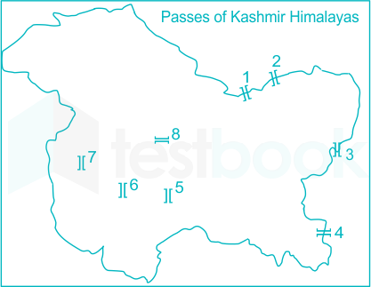
The map is showing the passes of the Kashmir Himalayas. Which of the sequence of labeled passes in ascending order is correct?

  1. AOption (a)
    1. Karakoram 2. Qura Tag 3. Lanak La 4. Chang La 5. Umasi La 6. Banihal 7. Pir Panjal. 8. Zoji La
  2. BOption (b)
    1. Karakoram 2. Qura Tag 3. Chang La 4. Lanak La 5. Umasi La 6. Banihal 7. Pir Panjal. 8. Zoji La
  3. COption (c)
    1. Karakoram 2. Aghil 3. Lanak La 4, Umasi La 5. Chang La 6. Banihal 7. Pir Panjal 8. Zoji La
  4. DOption (d)
    1. Karakoram 2. Saser La 3. Lanak La 4. Chang La 5. Umasi La 6 Pir Panjal 7. Qura Tag 8. Zoji La
View answer & explanation

Correct answer

Answer: (a)A.
  1. Karakoram 2. Qura Tag 3. Lanak La 4. Chang La 5. Umasi La 6. Banihal 7. Pir Panjal. 8. Zoji La

Why this answer is correct

Passes of the Kashmir Himalayas. the correct sequence of labeled passes in ascending order is 1. Karakoram 2. Qura Tag 3. Lanak La 4. Chang La 5. Umasi La 6. Banihal 7. Pir Panjal. 8. Zoji La

Key Points

  • Karakoram Pass:
  • The Karakoram Pass is a high-altitude mountain pass located in the Karakoram mountain range, between the borders of Pakistan and China.
  • It is located at an altitude of about 5,540 meters above sea level and provides a crucial link between the two countries.
  • Qura Tag Pass:
  • The Qura Tag Pass is located in the Karakoram mountain range, between Pakistan and China.
  • It is located at an altitude of about 5,540 meters above sea level and provides a crucial link for trade and transportation between the two countries.
  • Lanak La Pass:
  • The Lanak La Pass is a high-altitude mountain pass located in the Ladakh region of India.
  • It is located at an altitude of about 5,475 meters above sea level and provides a crucial link between the Ladakh region and the Tibet Autonomous Region of China.
  • Chang La Pass:
  • The Chang La Pass is a high-altitude mountain pass located in the Ladakh region of India.
  • It is located at an altitude of about 5,360 meters above sea level and provides a crucial link between the Ladakh region and the rest of India.
  • Umasi La Pass:
  • The Umasi La Pass is a high-altitude mountain pass located in the Ladakh region of India.
  • It is located at an altitude of about 5,319 meters above sea level and provides a crucial link between the Ladakh region and the rest of India.
  • Banihal Pass:
  • The Banihal Pass is a high-altitude mountain pass located in the Jammu and Kashmir region of India.
  • It is located at an altitude of about 2,832 meters above sea level and provides a crucial link between the Kashmir Valley and Jammu.
  • Pir Panjal Pass:
  • The Pir Panjal Pass is a high-altitude mountain pass located in the Jammu and Kashmir region of India.
  • It is located at an altitude of about 3,490 meters above sea level and provides a crucial link between the Kashmir Valley and the state of Himachal Pradesh.
  • Zoji La Pass:
  • The Zoji La Pass is a high-altitude mountain pass located in the Jammu and Kashmir region of India.
  • It is located at an altitude of about 3,527 meters above sea level and provides a crucial link between the Kashmir Valley and Ladakh.

Additional Information

A mountain pass is a low point or gap in a mountain range that allows for easier passage or travel between two points on opposite sides of the range. Mountain passes can play an important role in transportation, trade, and military operations.

There are several types of mountain passes, including:

  • Col: A col is a narrow pass or saddle between two peaks, often found in a ridge.
  • Notch: A notch is a narrow, V-shaped pass that is often found between two cliffs or walls.
  • Saddle: A saddle is a low point between two peaks, similar to a col but wider.
  • Gap: A gap is a wide, low point between two peaks or ridges.
  • Pass: A pass is a general term used to describe a low point in a mountain range that allows for easier travel or transportation.

Mountain passes can vary in their altitude, width, and degree of difficulty, and are often used as trade routes, military roads, or access points to remote or high-altitude areas. Mountain passes can also provide stunning scenic views and opportunities for recreation, such as hiking and mountain climbing.

Question 13

Match List I with List II

List I Transport Network Measures and ConnectivityList II Definition
(A)Eta Index(I)Measures the level of connectivity in a graph and is expressed by the relationship between the number of links over the number of nodes
(B)Theta Index(II)Average length per link
(C)Beta Index(III)Average amount of trafffic per intersection
(D)Alpha Index(IV)It evaluates the number of cycles in a graph in comparison with the maximum number of cycles

Choose the correct answer from the options given below:

  1. AOption (a)

    (A)-(II), (B)-(I), (C)-(III), (D)-(IV)

  2. BOption (b)

    (A)-(II), (B)-(IV), (C)-(III), (D)-(I)

  3. COption (c)

    (A)-(II), (B)-(III), (C)-(IV), (D)-(I)

  4. DOption (d)

    (A)-(II), (B)-(III), (C)-(I), (D) -(IV)

View answer & explanation

Correct answer

Answer: (d)D.

(A)-(II), (B)-(III), (C)-(I), (D) -(IV)

Why this answer is correct

The correct answer is (A)-(II), (B)-(III), (C)-(I), (D) -(IV)

Key PointsTransport Networks:

There are numerous nodes and links in transportation networks, making comparison difficult as network complexity increases.

  • For instance, determining which of two transportation networks is the most efficient or accessible.
  • Connectivity – The relative degree of connectedness within a transportation network.
  • High connectivity = Low isolation, high accessibility.
  • Low connectivity = High isolation, and low accessibility. Connectivity is a measure of accessibility without regard to distance

Indices of Network:

Indices are more intricate ways to depict a graph's structural characteristics since they compare one measure to another.

  • Some indices consider both the degree of activity (traffic)
  • Spatial characteristics (distance, surface), whilst others only consider the topological aspect of the network.

ETA Index:

  • Average link length As the average duration per link decreases, adding more nodes will result in a fall in Eta.
  • In general, complex networks have a low eta value.

Theta Index:

  • Theta Index determinates determine a node's function, which is the typical volume of traffic at each intersection.
  • The network is loaded more when theta is higher.
  • The metric can be used to describe the average load per link when applied to the number of links (edges).

Beta Index:

  • Its measures the relationship between the number of links (e) and the number of nodes to calculate the degree of connectedness in a graph (v).
  • Simple networks and trees both have beta values below one. One is the value of a connected network having one cycle.
  • Networks with more complexity have values greater than 1.
  • The greater the number of links in a network with a fixed number of nodes
  • The greater the number of pathways that can exist in the network.
  • A complex network has a high Beta value.
  • The rich-club coefficient measures whether the connection is higher among nodes of higher degree.

Alpha Index:

  • A measure of connectivity that compares a graph's number of cycles to its maximum number of cycles.
  • The more interconnected a network is, the higher the alpha index. Simple networks and trees will have a value of 0.
  • A network that is entirely connected has a value of 1. evaluates connection without regard to the number of nodes.

Hence,(A)-(II), (B)-(III), (C)-(I), (D) -(IV) is the correct answer.

Additional InformationGamma Index:

  • A connectivity measurement that takes into account the relationship between the quantity of observed linkages and the quantity of potential links.
  • Gamma's value ranges from 0 to 1, with a value of 1.
  • Its indicating a perfectly connected network, which is highly improbable.
  • Gamma is a useful number to gauge how a network changes over time.

Question 14

As per Census of India, 2011 arrange the following Union Territories in a descending order according to the recorded literacy rates.

(A) Chandigarh, Puducherry, Daman & Diu, Dadar Nagar Haveli

(B) Puducherry, Chandigarh. Dadar Nagar Haveli, Daman & Diu

(C) Chandigarh, Dadar Nagar Haveli, Puducherry, Daman & Diu

(D) Daman & Diu, Puducherry. Chandigarh. Dadar Nagar Haveli

(E) Daman & Due, Chandigarh, Puducherry, Dadar Nagar Haveli

Choose the correct answer from the options given below:

  1. AOption (a)

    (A) only

  2. BOption (b)

    (A) and (E) only

  3. COption (c)

    (A), (B) and (C) only

  4. DOption (d)

    (E) only

View answer & explanation

Correct answer

Answer: (d)D.

(E) only

Why this answer is correct

The correct answer is (E) only.

Key PointsLiteracy Rate: 

  • Total number of literate people in a certain age group expressed as a share of that age group's overall population. The youth literacy rate evaluates literacy among people aged 15 to 24,
  • While the adult literacy rate assesses literacy among those over the age of 15.
Union TerritoriesLiteracy Rate (%)
Dadra and Nagar Haveli77.65
Daman and Diu87.07
Delhi86.34
Lakshadweep92.28
Puducherry85.85
A&N island74.04
Chandigarh86.05

Hence,(E) only is the correct answer.

Additional Information

  • Kerala has the highest overall and female literacy rates, while Lakshadweep had the highest male literacy rate, according to the 2011 Census.
  • The least literate state is Andhra Pradesh.
  • The lowest male literacy rate is in Rajasthan, while the lowest female literacy rate is in Bihar.
StateLiteracy Rate (%)
Kerala96.2
Mizoram91.3
Tripura88.8
Goa88.7
Himachal Pradesh86.6

Question 15

Match List I with List II

List IList II Concept/Term/Contribution
(A)Gaylord Nelson(I)Ecology
(B)A.E. Douglas(II)Ecological Niche
(C)Charles Elton(III)Earth day
(D)Ernst Haeckel(IV)Dendrochronology

Choose the correct answer from the options given below:

  1. AOption (a)

    (A) - (I), (B) - (III), (C) - (IV), (D) - (II)

  2. BOption (b)

    (A) - (III), (B) - (IV), (C) - (II), (D) - (I)

  3. COption (c)

    (A) - (II), (B) - (III), (C) - (I), (D) - (IV)

  4. DOption (d)

    (A) - (IV), (B) - (I), (C) - (III), (D) - (II)

View answer & explanation

Correct answer

Answer: (b)B.

(A) - (III), (B) - (IV), (C) - (II), (D) - (I)

Why this answer is correct

The correct answer is (A) - (III), (B) - (IV), (C) - (II), (D) - (I).

Key Points

 Ecology:

  • Ecology is the study of the environment.
  • It enables us to comprehend how different types of creatures coexist in various kinds of physical settings.
  • Ecology first gained popularity in the 1960s.
  • A time when environmental challenges were becoming more well-known.
  • German naturalist Ernst Haeckel first used the term "ecology"
  • He describes the "relation of the animal to its organic as well as its inorganic environment."

Ecological Niche:

  • The ecological niche explains the relationships between species in an environment.
  • A species' ability to thrive and persist depends on both biotic and abiotic conditions, which determine its niche.
  • Charles Elton (1927), further developed this approach with the concept of ecological niches.

Earth day:

  • Every year on April 22, there is an event called Earth Day to show support for environmental preservation.
  • It was first conducted on April 22nd, 1970, and currently features a variety of activities that are organized globally by EARTHDAY.
  • The junior senator from Wisconsin, Gaylord Nelson, has long been concerned about the state of the environment.
  • In the country. Then, in Santa Barbara, California.
  • In January 1969, he and numerous other people saw the devastation caused by a major oil spill.
  • On 22nd April, he lead a mass protest with the student to save the environment and protect the earth.

Dendrochronology:

  • The scientific process of dating tree rings, also known as growth rings.
  • The precise year they originated is termed dendrochronology (or tree-ring dating).
  • The study of climatic and atmospheric conditions during various historical periods from wood.
  • The University of Arizona's Laboratory of Tree-Ring Research was established by astronomer A. E. Douglass
  • In an effort to better understand sunspot cycles, Douglass postulated that shifts in solar activity would have an impact on global climate patterns, which would then be reflected in the growth patterns of tree rings.

Hence,(A) - (III), (B) - (IV), (C) - (II), (D) - (I) is the correct answer.

Question 16

Ammonification is an important process in:

  1. AOption (a)

    Phosphorus cycle

  2. BOption (b)

    Carbon cycle

  3. COption (c)

    Nitrogen cycle

  4. DOption (d)

    Oxygen cycle

View answer & explanation

Correct answer

Answer: (c)C.

Nitrogen cycle

Why this answer is correct

The correct answer is Nitrogen cycle.

Key PointsAmmonification:-

  • The five-step nitrogen cycle, which includes ammonification, is critical for supplying living things with the necessary nitrogen.
  • Decomposers, which reduce animal and plant cells to simpler components.
  • Its release of nutrients into the ecosystem, are necessary for ammonification to occur.
  • Ammonification is the process by which organic nitrogen.
  • It makes up the majority of the molecules in living things is changed into inorganic ammonia (NH3) or ammonium ions (NH4+).

Nitrogen cycle:

  • The flow of nitrogen atoms through Earth's living and non-living processes is referred to as the nitrogen cycle.
  • Life on Earth depends on the nitrogen cycle.
  • The cycle transforms atmospheric nitrogen into a form that plants may use to create new proteins.

Hence, the correct answer is the Nitrogen cycle

Additional InformationPhosphorus Cycle:

  • The process by which phosphorus travels through the lithosphere, hydrosphere, and biosphere is known as the phosphorus cycle.

Carbon cycle:

  • The carbon cycle explains how carbon moves between several Earth-based reservoirs.
  • This cycle is crucial for preserving the Earth's carbon balance and stable temperature.

Oxygen cycle:

  • The oxygen cycle, along with the carbon and nitrogen cycles, is crucial to the continuation of life on Earth.
  • The oxygen cycle is a biological process that travels through the atmosphere.
  • Oceans, and land to help maintain the level of oxygen on earth. Lithosphere.

Question 17

To examine the state of world environment and development beyond 2000. UN General Assembly set up World Commission on Environment and Development (WCED) in 1983. which is also known as:

  1. AOption (a)

    Commission on Sustainable Development 

  2. BOption (b)

    Brundtland Commission

  3. COption (c)

    Agenda - 21

  4. DOption (d)

    Chipko Movement

View answer & explanation

Correct answer

Answer: (b)B.

Brundtland Commission

Why this answer is correct

The correct answer is Brundtland Commission.

Key Points

  • A division of the United Nations (UN) with the objective of bringing nations together in the pursuit of sustainable development.
  • The Brundtland Commission was originally known as the World Commission on Environment and Development.
  • It was established in 1983 when Gro Harlem Brundtland
  • Due to her extensive training in the sciences and public health, Brundtland was selected.
  • Our Common Future, widely known as the Brundtland Report.
  • The Brundtland Commission was formally dissolved in 1987.
  • The 1991 Grawemeyer Award-winning document popularised the term "sustainable development."

Hence, Brundtland Commission is the correct answer.

Additional Information

Commission on Sustainable Development:

  • The 1992 United Nations Conference on Environment and Development.
  • Earth Summit's outcomes were to be overseen by the United Nations Commission on Sustainable Development (CSD).
  • An entity under the UN Economic and Social Council (ECOSOC).

Agenda - 21:

  • At the United Nations Conference on Environment and Development (UNCED).
  • It took place in Rio de Janeiro, Brazil, from June 3 to 14, 1992.
  • More than 178 governments adopted Agenda 21, the Rio Declaration on Environment and Development.
  • The Statement of Principles for the Sustainable Management of Forests.

Chipko movement:

  • The Chipko movement, also known as the Chipko Andolan.
  • It was a nonviolent social and environmental movement launched by rural Indian peasants
  • Notably women, in the 1970s. Its goal was to defend forests and trees from government-sponsored logging.

Question 18

Match List I with List II

List I Thematic MapsList II Data Type represented: Example
(A)Qualitative(I)Interval and Ratio Data: Chropleth maps
(B)Semi-Quantitative(II)Virtual maps generated digitally using computers: Landform maps
(C)Quantitative(III)Nominal Data: Chorochromatic maps
(D)Spatial(IV)Symbolization/Ordinal data: choroschematic map

Choose the correct answer from the options given below:

  1. AOption (a)

    (A) - (III), (B) - (I), (C) - (II), (D) - IV)

  2. BOption (b)

    (A) - (III), (B) - (IV), (C) - (II), (D) - (I)

  3. COption (c)

    (A) - (III), (B) - (IV), (C) - (I), (D) - (II)

  4. DOption (d)

    (A) - (III), (B) - (II), (C) - (IV), (D) - (I)

View answer & explanation

Correct answer

Answer: (c)C.

(A) - (III), (B) - (IV), (C) - (I), (D) - (II)

Why this answer is correct

The correct answer is (A) - (III), (B) - (IV), (C) - (I), (D) - (II).

Key PointsThematic Maps:

  • Thematic maps are single-topic diagrams with a certain theme or phenomenon in mind.
  • Population density, precipitation and rainfall amounts, vegetation distribution, or poverty.
  • This contrasts with reference maps, which incorporate a variety of features like terrain, roads, and political boundaries.
Thematic MapsCharacteristics
Qualitative- The spatial extent of category or nominal data is displayed on qualitative thematic maps (e.g., soil type, land cover, political districts). - On the other hand, quantitative thematic maps show the spatial patterns of numerical data. - Some examples are income, age, and population. - Nominal data has been shown.
Semi-Quantitative- Statistics and probability are part of a semi-quantitative map. - The semi-quantitative analysis is roughly correlated rather than accuracy driven. - Semi Quantification where a trustworthy sense of measurement is useful. - Quantifiable data may fluctuate repeatedly.
Quantitative- A quantitative Map is the process of gathering and interpreting numerical data. - It has the ability to find trends and averages. - Predict outcomes, investigate causal linkages, and extrapolate findings to broader populations.
Spatial- Using spatial mapping, developers may produce a believable mixed-reality experience by accurately representing real-world surfaces - A program can make holograms look real by fusing the physical and digital worlds. - Applications can more easily conform to user expectations. - Its prepared digital Map making by helping of GIS.

Hence, (A) - (III), (B) - (IV), (C) - (I), (D) - (II) is the correct answer.

Question 19

Given below are two statements: one is labeled as Assertion A and the other is labeled as Reason R

Assertion (A): During an equinox the length of daylight is 12 hours everywhere on Earth

Reasons (R): On equinox the circle of illumination passes directly through the poles dividing the latitudes in half

In the light of the above statements, choose the most appropriate answer from the options given below

  1. AOption (a)

    Both (A) and (R) are correct and R is the correct explanation of A

  2. BOption (b)

    Both (A) and (R) are correct but R is NOT the correct explanation of A

  3. COption (c)

    (A) is correct but (R) is not correct

  4. DOption (d)

    (A) is not correct but (R) is correct

View answer & explanation

Correct answer

Answer: (a)A.

Both (A) and (R) are correct and R is the correct explanation of A

Why this answer is correct

The correct answer is Both (A) and (R) are correct and R is the correct explanation of A.

Key Points 

Equinox:

  • An equinox is a time when the subsolar point of a planet crosses through its equator.
  • The Northern and Southern Hemispheres are practically equal during the equinoxes.
  • Two equinoxes occur annually on Earth.
  • One around March 21 and the other around September 22.
  • Even though the spring and fall equinoxes have different dates in the Northern and Southern Hemispheres.
  • The equinoxes are occasionally referred to as the "vernal equinox" (spring equinox) .
  • The "autumnal equinox" (fall equinox).
  • Solar declination describes the latitude of the Earth where the sun is directly overhead at noon.
  • When light travels through Earth's atmosphere, it seems to bend or diverge from a straight path. This phenomenon is known as atmospheric refraction. An equinox indicates equally illuminated hemispheres,
  • A true equinox would indicate 12 hours of both day and night.

Hence, Both (A) and (R) are correct and R is the correct explanation of A

Additional Information

  • Earth’s Equator experience relatively constant sunlight and little equinoctial variation.
  • At about 30° latitude, the day is about eight minutes longer than the night
  • The Arctic and Antarctic, with daylight extending about 12 hours and 16 minutes

Question 20

Which one of the following statistical technique is used to analyse the interdependence of the variables?

  1. AOption (a)

    Location Quotient

  2. BOption (b)

    Standard Score

  3. COption (c)

    Co-efficient of variability

  4. DOption (d)

    Principal Components Analysis

View answer & explanation

Correct answer

Answer: (d)D.

Principal Components Analysis

Why this answer is correct

The correct answer is Principal Components Analysis

Key PointsVariables:

  • A variable is an attribute of an object of study in statistical research. A successful experimental design depends on the selection of the variables to be measured.
  • Interdependence methods seek to give meaning to a set of variables or to group them together in meaningful ways.
  • One is about the effect of certain variables on others, while the other is all about the structure of the dataset.
  • Principal Components Analysis (PCA) is a statistical technique used to analyze the interdependence or relationships between variables.
  • PCA is particularly helpful when dealing with a large number of variables and aims to reduce the dimensionality of the dataset while preserving the maximum amount of variation in the data.
  • PCA identifies patterns and correlations among variables by transforming the original variables into a new set of uncorrelated variables called principal components. These components are linear combinations of the original variables and are ordered in terms of their ability to explain the variance in the data.

Additional Information

  • A location quotient measures how concentrated a sector or even a specific population group is in a region relative to the entire country.
  • A potent method for locating expansion prospects and comparative geographical benefits is to use the location quotient.
  • The coefficient of variability displays the degree of data variability in a sample in comparison to the population mean.
  • The coefficient of variation in finance enables investors to assess how much risk, or volatility is assumed relative to the amount of return anticipated from investments.
  • The data's dimensionality is decreased but the majority of the data set's variation is preserved 1.
  • This reduction is achieved by locating the primary components—or directions—along which the data's variation is greatest.

Question 21

Which of the following are characterized by stratovolcanoes?

(A) Basaltie magma

(B) Involves inter layered strata

(C) Magma is gassy and highly viscous

(D) Magma emerges under low pressure

Choose the correct answer from the options given below:

  1. AOption (a)

    (A) and (D) only

  2. BOption (b)

    (B) and (D) only

  3. COption (c)

    (A) and (C) only

  4. DOption (d)

    (B) and (C) only

View answer & explanation

Correct answer

Answer: (d)D.

(B) and (C) only

Why this answer is correct

The Correct answer is: B and C

Key Points

  • (A) Basaltic magma
  • This statement is incorrect.
  • Stratovolcanoes (composite volcanoes) are typically fed by intermediate to felsic magmas (andesitic to dacitic), not predominantly basaltic.
  • Basaltic magma is low in silica and low in viscosity, favoring broad, gently sloping shield volcanoes (e.g., Hawaii), not steep stratocones.
  • While some stratovolcanoes may occasionally erupt basalt, it is not the characteristic magma type that defines the morphology and eruptive style of stratovolcanoes.
  • (B) Involves inter layered strata
  • This statement is correct.
  • Stratovolcanoes are built from alternating layers (strata) of lava flows, ash, lapilli, and pyroclastic deposits.
  • These interbedded layers result from cycles of effusive lava effusions and explosive tephra-producing eruptions, creating the classic steep-sided cone.
  • The layered architecture enhances mechanical strength in places but can also create internal weaknesses along ash-rich horizons.
  • (C) Magma is gassy and highly viscous
  • This statement is correct.
  • Higher silica content (andesite–dacite–rhyolite) increases viscosity, trapping volatiles (H2O, CO2, SO2).
  • Gas-rich, viscous magma favors pressurization and explosive fragmentation, producing ash columns, pumice, and pyroclastic flows—hallmarks of stratovolcanic activity.
  • Viscosity also promotes dome growth and short, thick lava flows rather than long, fluid basaltic flows.
  • (D) Magma emerges under low pressure
  • This statement is incorrect.
  • Stratovolcano eruptions commonly involve high internal pressures due to volatile buildup in viscous magma, leading to explosive eruptions.
  • Low-pressure, passive degassing is more consistent with fluid basaltic systems; stratovolcanoes are noted for overpressure-driven events (e.g., Plinian columns, lateral blasts).
  • The steep cone and frequent explosive deposits reflect these higher-pressure eruptive dynamics.

Additional Information

  • Stratovolcano Basics:
  • Also called composite volcanoes; steep, conical edifices formed at convergent plate margins, especially subduction zones.
  • Common hazards include ashfall, pyroclastic density currents, lava domes and collapses, lahars, and volcanic bombs.
  • Magma Composition & Eruption Style:
  • Typical magmas: andesite to dacite (intermediate–felsic), sometimes grading to rhyolite; these are viscous and volatile-rich.
  • Eruptions range from Vulcanian to Plinian; effusive phases produce short, thick lava flows and domes between explosive episodes.
  • Examples:
  • Mount Fuji (Japan), Mount St. Helens (USA), Mount Vesuvius (Italy), Mount Merapi (Indonesia).
  • Why Layers Form:
  • Alternation of eruptive styles (explosive tephra vs. effusive lava) through time lays down distinct strata, giving the “composite” structure and name.

Question 22

In 2020-21, India exported poultry products to which of the following countries?

(A) Oman

(B) Maldives

(C) Pakistan

(D) Indonesia

(E) Thailand

Choose the correct answer from the options given below:

  1. AOption (a)

    (A) only 

  2. BOption (b)

    (A) and (B) only

  3. COption (c)

    (C) and (E) only

  4. DOption (d)

    (A), (B) and (D) only

View answer & explanation

Correct answer

Answer: (d)D.

(A), (B) and (D) only

Why this answer is correct

The correct answer is (A), (B) and (D) only.

Key Points

  • Domesticated birds or broilers are raised, hatched, bred, and processed as poultry.
  • It typically comprises animals farmed primarily for their meat and eggs, such as chickens, ducks, turkeys, and geese.
  • During the past 20 years, India's poultry sector has undergone major statistical progress.
  • As well as a full transformation of its entire structure and operation.
  • Due to a large number of integrated companies and a sizable investment in breeding, hatching, rearing, and processing activities.
  • it has developed from a simple traditional backyard activity into a fully-fledged commercial business.
  • The country India has exported 2,55,686.92 MT of Poultry products to the world.
  • For the worth of Rs. 435.53 Crores/ 58.70 USD Millions during the year 2020-21.
  • Major Export Destinations (2020-21): Oman, Maldives, Indonesia, Vietnam Soc Rep, Russia.
  • Hence, The correct answer is Oman, Maldives, and Indonesia.

Question 23

Cambay Graben is associated with which one of the following earthquake?

  1. AOption (a)

    Bhuj earthquake

  2. BOption (b)

    Latur earthquake

  3. COption (c)

    Jabalpur earthquake

  4. DOption (d)

    Quetta, Baluchistan earthquake

View answer & explanation

Correct answer

Answer: (a)A.

Bhuj earthquake

Why this answer is correct

Key Points

Earthquake, any sudden ground trembling brought on by seismic waves moving through the planet's rocks.

  • When a kind of energy held inside the Earth's crust is abruptly released.
  • Typically when masses of rock rubbing up against one another unexpectedly crack and "slide," seismic waves are created.
  • Geologic faults, which are confined areas .
  • Several faults have been identified in this region out of which many show evidence of movement .
  • During the Holocene epoch.
  • The Cambay Graben terminates in the south-western part of the state of Gujrat.
  • The formation of the Cambay Basin began following the extensive outpour of Deccan basalts (Deccan Trap).
  • During late Cretaceous covering large tracts of western and central India.
  • The NW-SE Dharwarian tectonic trends got rejuvenated.
  • The total volume of seismic reflection data acquired from the Cambay Basin is of the order of 104113 LKM (2D) and 7895 sq. km (3D).
  • In 1958, ONGC drilled its first exploratory well on Lunej structure near Cambay.
  • The Bhuj earthquake, sometimes referred to as the Gujarat earthquake of 2001,
  • Struck on January 26 at 8:46 IST in Cambay Basin.
  • In Gujarat, India's Kutch District, Bhachau Taluka, the  epi centre of the earthquake was located around 9 km south-southwest of the village of Chobari.

Hence, The Correct answer is Bhuj earthquake​

Additional Information

  • The 1993 Latur earthquake struck India at 3:56 am local time on 30 September.
  • The main area affected is the districts of Latur and Osmanabad.
  • The 1997 Jabalpur earthquake occurred on May 22, at 04:21:31 AM in Jabalpur District.
  • The epicenter of the earthquake was located near Koshamghat village.

Causes of Earthquake:

  • Earthquakes are caused due to release of energy. The release of energy occurs along a fault. A fault is a sharp break in the crustal rocks.
  • Rocks along a fault tend to move in opposite directions. As the overlying rock strata press them, the friction locks them together.
  • However, their tendency to move apart at some point of time overcomes the friction.
  • As a result, the blocks get deformed and eventually, they slide past one another abruptly.
  • This causes a release of energy, and the energy waves travel in all directions.
  • Volcanic earthquakes are caused by slip on a fault near a volcano.
  • Induced seismicity refers to typically minor earthquakes and tremors that are caused by human activity.

Question 24

Arrange the following trace gases in correct sequence of their concentration in atmosphere in descending order:

(A)Methane

(B) Krypton

(C) Helium

(D) Neon

(E)  Hydrogen

Choose the correct answer from the options given below:

  1. AOption (a)

    (E), (B), (D), (A), (C)

  2. BOption (b)

    (D), (B), (E), (A), (C)

  3. COption (c)

    (D), (C), (A), (B), (E)

  4. DOption (d)

    (D), (E), (B), (A), (C)

View answer & explanation

Correct answer

Answer: (c)C.

(D), (C), (A), (B), (E)

Why this answer is correct

Key Points

Trace Gases:

Any form of gas that occurs in minute concentrations—many of them at levels of one part per billion (ppb) or less—is referred to as a trace gas.

  • When speaking of gases found in the Earth's atmosphere, the term "trace gases" is frequently used.
  • Less than 1% of the atmospheric gases in this situation are trace gases.
  • The most important trace gases found in Earth's atmosphere are the so-called greenhouse gases
  • They help to keep Earth warm by absorbing light from the sun.
  • These gases include water vapor, ozone (O3), CO2, methane (CH4), SO2, and Nitrus Oxide (N2O).
  • The two most abundant greenhouse gases by volume are water vapor and Carbon.
Traces GassesParts per million (ppm)
Carbon Dioxide409 ppm
Methane1.8 ppm
Neon18 ppm
Krypton1 ppm
Helium5 ppm
Hydrogen0.5 ppm

Hence,(D), (C), (A), (B), (E) is the correct answer.

Additional Information

Abundant Gas:

The most abundant gases in Earth's atmosphere depend on the region of the atmosphere and other factors. Since the chemical composition of the atmosphere depends on temperature, altitude, and proximity to water. Usually, the 4 most abundant gases are:

  1. Nitrogen (N2) -  78.084%
  2. Oxygen (O2) - 20.9476%
  3. Argon (Ar) - 0.934%
  4. Carbon dioxide (CO2) 0.0314%

Question 25

Niche Market tour operators have increased in number to satisfy specialist holiday. which includes:

(A) Theme Parks

(B) Cruise

(C) Sports tourism

(D) Family Gathering tourism

Choose the correct answer from the options given below:

  1. AOption (a)

    (A), (B) and (C) only

  2. BOption (b)

    (A), (B) and (D) only

  3. COption (c)

    (A), (C) and (D) only

  4. DOption (d)

    (D) only

View answer & explanation

Correct answer

Answer: (a)A.

(A), (B) and (C) only

Why this answer is correct

Confusion PointsAs per the official answerkey provided by UGC, the correct answer is (A), (C) and (D) only. But, (A), (B) and (C) are the sub-cstegories of Niche Market tourism. So, option 1 or (A), (B) and (C) only has markes as the correct answer in this question.

Key Points

Niche Market:

Niche Market is an umbrella tourism type, which defines macro and micro tourism sectors attractive to a certain set of travelers.

  • Tour operators are specialised or small firms that market specialist travel items.
  • Niche market enables you to focus more on details .
  • Develop experiences that fit the needs of your ideal customer 100%.

Examples of niched tour operators are:

  • Adventure tour operators
  • Ecotour agencies
  • Food tour operators
  • Motorcycle tour operators
  • Operators focused on pet-friendly activities

Importance:

  • Culinary lunches and dinners
  • Tour operators offering sufferies
  • Give importance on Theme park & Wild life.
  • It also focus on the sports tourism like horse riding ,  organised difference sports based on tourism.

 Hence, (A), (B) and (C) only is the correct answer

Additional Information

  • Tourism is one of the world’s fastest-growing industries and a major foreign exchange and employment generation for many countries.
  • It is one of the most remarkable economic and social phenomena.
  • International Tourism. To travel to a foreign country, one needs a valid passport, visa, health documents, foreign exchange, etc
  • Inbound tourism for the country where they are traveling
  • Adventure tour operators Ecotour agencies Food tour operators Motorcycle tour operators Operators focused on pet-friendly activities.
  • Outbound tourism for their own country because they are going outside their country.
  • The tourism activity of the people within their own country is known as domestic tourism.

Question 26

Given below are two statements: one is labeled as Assertion A and the other is labeled as Reason R

Assertion (A): Any lack of water to satisfy the normal needs of agriculture. livestock, industry or human population may be termed as a drought

Reasons (R): Drought is a distress situation caused by lack of rainfall

In the light of the above statements, choose the most appropriate answer from the options given below:

  1. AOption (a)

    Both (A) and (R) are correct and R is the correct explanation of A

  2. BOption (b)

    Both (A) and (R) are correct but R is NOT the correct explanation of A

  3. COption (c)

    (A) is correct but (R) is not correct

  4. DOption (d)

    (A) is not correct but (R) is correct

View answer & explanation

Correct answer

Answer: (a)A.

Both (A) and (R) are correct and R is the correct explanation of A

Why this answer is correct

Key PointsAssertion (A): Any lack of water to satisfy the normal needs of agriculture. livestock, industry or human population may be termed as a drought

  • Drought:
  • Drought is a temporary reduction in water or moisture availability significantly below the normal or expected amount for a specific period.
  • Ecological Drought: Productivity of a natural eco-system falls significantly as a consequence of distress induced environmental damage.

​​Present Status:

  • In India, since 60% of the agriculture is still rainfed, meteorological drought is an important cause of drought conditions.
  • Inadequacy of rainfall, or lack of irrigation facilities.
  • Under-exploitation or deficient availability** of water for meeting the normal crop.**

 Reason: Drought is a distress situation caused by lack of rainfall

  • Drought is a distress situation caused by lack of rainfall.
  • Due to lack of availability of natural water ,agricultural** land are  effected .**
  • The inadequacy is with reference to the prevailing agro-climatic conditions
  • Insufficient water supplied for any need of physical features is termed as Drought.
  • Drought impacts to agriculture depend on underlying social and ecosystem vulnerabilities,
  • Some droughts have occurred naturally, plaguing humankind throughout much of our history.
  • The distribution of rainfall around the world can also be affected by how air circulates through the atmosphere.
  • Drought can also result because of an imbalance in the supply and demand of water.
  • When forests and vegetation disappear, less water is available to feed the water cycle, making entire regions more vulnerable to drought.
  • The planet is being warmed at alarming rates and could cause droughts.

**Hence, Both (A) and (R) are correct and R is the correct explanation of A is the correct answer.**​​

Question 27

Which one of the following is not correctly matched?

  1. AOption (a)

    Cherry Blossoms - Karnataka

  2. BOption (b)

    Norwesters - West Bengal, Assam and Odisha

  3. COption (c)

    Loo-North India 

  4. DOption (d)

    Mango showers - Maharashtra 

View answer & explanation

Correct answer

Answer: (d)D.

Mango showers - Maharashtra 

Why this answer is correct

Key Points

Cherry Blossoms- The streets of Karnataka have turned in hues of pink color. - The cherry blossoms have taken over the city in full bloom in the time of onset of Monsoon. - These cherry blossoms come from a neotropical tree called Tabibuea Rosea.
Norwesters- Nor'westers, also known as the Kalbaishakhi or Bordoisila in Assam, are localised periods. - In the time of  heavy rain and thunderstorms that also affect Bangladesh and the Indian states of Bihar, Jharkhand, Odisha, Tripura, and West Bengal. - They can reach speeds of more than 100 km/h (62 mph). - When these storms start to form thick, dark, black clouds over the sky in the late afternoon or right before sunset, - They typically bring gale-force winds, torrential rain, and sometimes hail for a brief period of time.
Loo- The Indo-Gangetic Plain receives scorching breezes from the west known as loo. - As a result, it primarily affects North India and Pakistan.
Mango Shower- Karnataka and Kerala are affected because they are coastal states. - 'Mango showers' are typical in the states of Kerala and Karnataka. - Pre-monsoon rains are referred to as mango showers in the states of Karnataka, Kerala,

Hence, Mango showers - Maharashtra is not correctly matched.

Question 28

A regressive population age structure is likely to be encountered in a country:

  1. AOption (a)

    which has completed the demographic transition

  2. BOption (b)

    where the young and old population are balanced

  3. COption (c)

    which has young population

  4. DOption (d)

    which is in the early expanding stage of demographic transition

View answer & explanation

Correct answer

Answer: (a)A.

which has completed the demographic transition

Why this answer is correct

A regressive population age structure is characterized by a relatively high proportion of elderly people and a low proportion of young people. This can be caused by low birth rates, high death rates, and increased life expectancy.

Important Points

  • A regressive population age structure is unlikely to be encountered in a country that has completed the demographic transition because in such countries, the population tends to have a more balanced age structure with a relatively smaller proportion of elderly people.
  • A balanced population age structure with a relatively equal proportion of young and old population is not indicative of a regressive population age structure.
  • A young population age structure is indicative of an expanding population, where there is a high proportion of young people and a low proportion of elderly people.
  • A country in the early expanding stage of demographic transition is likely to have a young population age structure, not a regressive one.

Therefore, option 1 is the correct answer.

Question 29

Which of the following statements is/are colrect?

(A) The BOD (Biological Oxygen Demand) of sewage water is very high

(B) The aerobic organisms rapidly increase in sewage water due to low content of dissolved oxygen

(C) Ecology is the study of interrelationship between the organisms and their physical environment

(D) Parasites are those organisms, which do not depend on other living organisms for their food

Choose the correct answer from the options given below:

  1. AOption (a)

    (A) only

  2. BOption (b)

    (C) only

  3. COption (c)

    (A) and (C) only

  4. DOption (d)

    (B) and (D) only

View answer & explanation

Correct answer

Answer: (c)C.

(A) and (C) only

Why this answer is correct

The correct answer is option third) (A) and (C) only.

Key Points

  • (A) The BOD (Biological Oxygen Demand) of sewage water is very high.
  • This statement is correct.
  • Biological Oxygen Demand (BOD) is a measure of the amount of oxygen that microorganisms need to break down organic matter in water.
  • Sewage water is high in organic matter due to the presence of human waste, food waste, and other organic materials.
  • This organic matter in sewage water requires a lot of oxygen to be broken down by microorganisms, leading to a high BOD value.
  • High BOD values indicate that a large amount of oxygen is being consumed, which can harm aquatic life and reduce the overall health of the ecosystem.
  • (B) The aerobic organisms rapidly increase in sewage water due to the low content of dissolved oxygen.
  • This statement is incorrect.
  • Aerobic organisms are those that require oxygen to survive.
  • Low content of dissolved oxygen in sewage water would actually reduce the number of aerobic organisms as they depend on dissolved oxygen for their survival.
  • In contrast, anaerobic organisms, which do not require oxygen to survive, are likely to increase in sewage water due to the low content of dissolved oxygen.
  • (C) Ecology is the study of the interrelationship between organisms and their physical environment.
  • This statement is correct.
  • Ecology is the study of the interactions between organisms and their environment, including other organisms.
  • It encompasses the relationships between living organisms, their physical environment, and the ways in which they interact and depend on one another.
  • Ecology studies how species interact with each other and with their physical environment,
  • how ecosystems change over time, and how human activities affect the natural world.
  • (D) Parasites are those organisms, which do not depend on other living organisms for their food.
  • This statement is incorrect.
  • Parasites are organisms that depend on other living organisms for their food and survival.
  • They live in or on another organism (the host) and derive their nutrients from the host.
  • Examples of parasites include tapeworms, lice, and malaria-causing protozoa.

​thus the correct options are;

  • The BOD (Biological Oxygen Demand) of sewage water is very high
  • Ecology is the study of the interrelationship between organisms and their physical environment​**

Additional Information

Ecosystem:  An ecosystem consists of biotic components comprising living organisms and abiotic components comprising physical factors like temperature, rainfall, wind, soil, and minerals. 

  • All these living organisms interact with each other and their growth, reproduction, and other activities are affected by the abiotic components of the ecosystem.

The ecosystem is two types 

  • Natural ecosystem: This type of ecosystem is created by nature itself. For example forests, ponds, oceans, lakes, etc.
  • Artificial ecosystem: This type of ecosystem is created by human beings. For example crop fields, gardens, aquariums, dams, etc.

Question 30

Which of the following is/are not the cause/causes of floods in Brahmaputra river system?

(A) Tributaries of Brahmaputra bring huge quantity of water and silt, heavy deposit of silt has raised the river bed

(B) Faulty agricultural practices

(C) Occasional earthquakes have brought about changes in the course of river

(D) Broadness of the Brahmaputra Valley

(E) Very high population pressure has forced the population to live in the flood prone area

Choose the correct answer from the options given below:

  1. AOption (a)

    (A) only 

  2. BOption (b)

    (B) and (C) only 

  3. COption (c)

    (B) and (D) only 

  4. DOption (d)

    (E) only 

View answer & explanation

Correct answer

Answer: (c)C.

(B) and (D) only 

Why this answer is correct

The correct answer is (B) and (D) only.

Important Points 

(A) Tributaries of Brahmaputra bring huge quantities of water and silt, and heavy deposit of silt has raised the river bed -

  • This is a cause of floods in the Brahmaputra river system.
  • The tributaries bring large amounts of water and silt into the main channel, which can increase the volume of water and raise the river bed, making it more prone to flooding.

(C) Occasional earthquakes have brought about changes in the course of the river.

  • This statement is a cause of floods in the Brahmaputra river system.
  • Earthquakes can lead to changes in the course of the river, affecting its flow and potentially causing flooding in new areas.

(E) Very high population pressure has forced the population to live in the flood-prone area -

  • This is not a cause of floods in the Brahmaputra river system.
  • High population pressure can result in people living in flood-prone areas,
  • which can increase the impact of floods when they occur.
  • However, high population pressure does not directly cause floods. Instead, it is the natural processes such as heavy rainfall, snowmelt, or earthquakes that cause floods.

Key Points(B) Faulty agricultural practices -

  • This is not a cause of floods in the Brahmaputra river system.
  • Agricultural practices, such as excessive irrigation or the use of chemical fertilizers, can have negative impacts on local ecosystems and soil quality,
  • but they do not directly contribute to flooding in the Brahmaputra river system.

(D) Broadness of the Brahmaputra Valley -

  • This is not a cause of floods in the Brahmaputra river system.
  • The broadness of the Brahmaputra Valley can provide a large floodplain,
  • which can act as a natural buffer against floods, reducing their severity.
  • However, the broadness of the valley itself is not a direct cause of floods.

Additional Information  Brahmaputra River System:

  • It is known as Tsangpo in Tibet,
  • Dihang or Siang in Arunachal Pradesh,
  • the Brahmaputra in Assam,
  • Jamuna in Bangladesh.
  • The river originates at the Manasarover lake in Tibet.

Tributaries from the left bank are: 

  • Lhasa River, Nyang River, Parlung Zangbo, Lohit River, Dhansiri River and Kolong River

Tributaries from the right bank​ are:

  • ​Kameng, Manas, Beki, Raidak, Jaldhaka, Teesta and Subansiri River
  • Majuli is the largest riverine island in the world and is in the Brahmaputra River.
  • The combined stream of Ganga and Brahmaputra forms the biggest delta in the world, the Sunderbans.
  • The Brahmaputra is the volume-wise largest river in India, whereas lengthwise Ganga is the longest in India.
  • The Raidak river is also known as the Wang Chhu River.
  • It flows through Bhutan, India, and Bangladesh.
  • Chukha hydel plant and Tala Hydroelectric Power Station are located on the river.
  • About Bhramputra River:
LocationSource Himalayas
Mouth LocationGanges Delta
Left TributariesLhasa River, Lohit River, Nyang River, Kolong River
Right TributariesManas, Beki, Raidak, Kameng


​

Question 31

Which of the following pairs are correctly matched?

(A) Carl Ritter - Continentality concepts

(B) Alexander Von Humboldt - Teleological Approach

(C) Oscar Peschel - Das Ausland

(D) Varenius - Critique of Pure Reason

(E) Immanuel Kant - General History of Nature of the Heavens

Choose the correct answer from the options given below:

  1. AOption (a)

    (A) and (C) only

  2. BOption (b)

    (B) and (E) only

  3. COption (c)

    (D) and (E) only

  4. DOption (d)

    (C) and (E) only

View answer & explanation

Correct answer

Answer: (d)D.

(C) and (E) only

Why this answer is correct

The correct answer is (C) and (E) only.

Key Points

( A) Carl Ritter - Continentality concepts - is not a correct match

  • Carl Ritter was a German geographer and a pioneer in the field of biogeography.
  • he is not specifically associated with the concept of continentality.
  • He is known for his holistic, or teleological, approach to nature, which saw all aspects of the natural world as interconnected and part of a larger whole.

(B) Alexander Von Humboldt - Teleological Approach -  is not a correct match

  • Alexander von Humboldt was a German naturalist and explorer who made significant contributions to the fields of geography, botany, and geology.
  • He is known for his  Continentality concepts
  • He popularized the term continentality to describe the effect that a location's distance from an ocean has on its mean annual range of temperature.

(C) Oscar Peschel - Das Ausland is correct match

    • Oscar Peschel was a German geographer and historian.
  • He is known for his works on the geography of foreign lands, or "Das Ausland."
  • He wrote several works on the geography and history of various countries, including China, Japan, and India.

(D) Varenius - Critique of Pure Reason -is a not correct match

  • He was the first geographer to suggest the essential differ­ence between physical and human geography
  • "Critique of Pure Reason" is a book written by Immanuel Kant, a German philosopher, which deals with the nature of human knowledge and reason.

(E) Immanuel Kant - General History of Nature of the Heavens - is the correct match 

  • Immanuel Kant was a German philosopher who made significant contributions to the fields of epistemology and metaphysics.
  • He is also known for his book "General History of Nature of the Heavens," and "Critique of Pure Reason" which presents a systematic study of the physical universe and the natural laws that govern it.

Thus The correct answer is (C) and (E) only.

Important Points 

Continentality concepts:by Alexander Von Humboldt - - The concept of continentality refers to the influence of a continent's physical characteristics, such as its distance from the equator and the surrounding bodies of water, on its climate and vegetation. - Continentality is located in the interior of a continent or is a climate having characteristics similar to those found in such locations.
Teleological Approachby carl ritter Teleological Approach is based on the religious faith of man is superior to nature and all other creatures. This school emanated from the teaching of Judeo-Christian religious tradition which preached that ‘man is superior to all creatures and everything is created for his use and enjoyment’. This ideology of man- the environment/nature relationship fostered man to exploit natural resources and to subdue nature without considering the after-effects of reckless and uncontrolled plundering of natural resources.
Oscar Peschel- Das Ausland - Oscar Peschel was a German geographer and historian. - He is known for his works on the geography of foreign lands, or "Das Ausland." - He wrote several works on the geography and history of various countries, including China, Japan, and India.
Bernhard VareniusVarenius was the first geographer who differentiates physical and human geography. In 1650, he pub­lished his other book Geographia Generalis. he di­vided geography into ‘general’ and ‘special’ sections which led to the development of ‘systematic’ and ‘re­gional geography’.
Immanuel Kant- Immanuel Kant was a German philosopher who made significant contributions to the fields of epistemology and metaphysics . He is also known for his book "General History of Nature of the Heavens," which presents a systematic study of the physical universe and the natural laws that govern it." and "Critique of Pure Reason"

Question 32

The report entitled "Our Common Future" was submitted in 1987 by:

  1. AOption (a)

    Food and Agricultural Organization 

  2. BOption (b)

    World Meteorological Organization

  3. COption (c)

    Intergovernmental Panel on climate change

  4. DOption (d)

    Brundtland Commission

View answer & explanation

Correct answer

Answer: (d)D.

Brundtland Commission

Why this answer is correct

the correct option is Brundtland Commission 

Important Points 

  • The first Earth Summit took place in Rio de Janeiro in June 1992.
  • The Rio Declaration on Environment and Development, Agenda 21, Convention on Biological Diversity, Forest Principles, and the Framework Convention on Climate Change came out of the 1992 Earth Summit.
  • Sustainable development was developed for the first time in the Brundtland Commission Report in 1987.
  • The Brundtland Report was published by the United Nations World Commission on Environment and Development in 1987.
  • According to the report, "Sustainable development is the development that meets the needs of the present without compromising the ability of future generations to meet their own needs."
  • This most widely accepted definition of Sustainable Development was given by the Brundtland Commission in its report Our Common Future (1987).
  • Sustainable development (SD) calls for concerted efforts toward building an inclusive, sustainable, and resilient future for people and the planet.​

Additional Information

 the 2030 agenda for Sustainable Development” was adopted at the United Nations Sustainable Development Summit. SDGs are the outcome of the Rio+20 conference (2012) held in Rio De Janerio and are a non-binding document.

It is a group of 17 goals with 169 targets and 230 indicators,

  • There are 17 Sustainable Development Goals-
  • GOAL 1: No Poverty.
  • GOAL 2: Zero Hunger.
  • GOAL 3: Good Health and Well-being.
  • GOAL 4: Quality Education.
  • GOAL 5: Gender Equality.
  • GOAL 6: Clean Water and Sanitation.
  • GOAL 7: Affordable and Clean Energy.
  • GOAL 8: Decent Work and Economic Growth.
  • GOAL 9: Industry, Innovation, and Infrastructure.
  • GOAL 10: Reduced Inequality.
  • GOAL 11: Sustainable Cities and Communities.
  • GOAL 12: Responsible Consumption and Production.
  • GOAL 13: Climate Action.
  • GOAL 14: Life Below Water.
  • GOAL 15: Life on Land.
  • GOAL 16: Peace and Justice Strong Institutions.
  • GOAL 17: Partnerships to Achieve the Goal.

Question 33

Match List I with List II

List I Minerals/Power resourcesList II Name of mines
(A)Manganese(I)Dungarpur, Malanjkhand
(B)Copper(II)Balaghat, Chhindwada
(C)Bauxite(III)North Karnpur, Jhilmili
(D)Coal(IV)Bolangir, Udgeri

Choose the correct answer from the options given below:

  1. AOption (a)

    (A)-(II), (B)-(I), (C) -(IV), (D) - (III)

  2. BOption (b)

    (A)-(II), (B)-(I), (C)-(III), (D)-(IV)

  3. COption (c)

    (A)-(I), (B)-(IH), (C)-(IV), (D)-(III)

  4. DOption (d)

    (A)-(III), (B)-(I), (C)-(IV), (D)-(II)

View answer & explanation

Correct answer

Answer: (a)A.

(A)-(II), (B)-(I), (C) -(IV), (D) - (III)

Why this answer is correct

The correct option is (A)-(II), (B)-(I), (C) -(IV), (D) - (III)

Additional Information 

Manganese - (II)

  • Balaghat, Chhindwada:
  • In Madhya Pradesh, manganese ore is found in Balaghat, Chhindwara, and Jhabua districts.
  • Manganese is an important mineral used in the production of steel and alloys,
  • India was the seventh-largest producer of manganese.
  • As with China and Brazil, India is one of the leaders in manganese consumption, as well as one of the top producers in the world.

Copper-

  • Dungarpur, Malanjkhand:
  • Malanjkhand also referred to as MCP (an acronym for Malanjkhand Copper Project) is an open-pit copper mine in India, located near the town of Malanjkhand, 90 kilometers (56 mi) northeast of Balaghat in Madhya Pradesh, at an altitude of 576 MRL.
  • Chile has been the world’s leading producer of copper since the early 21st century.
  • Copper production in India is only about 2 percent of world copper production in view of its potential reserve limited to 60,000 km (2% of world reserve)
  • other mines are;
  • Khetri MineLocated in Rajasthan, the Khetri Mine is owned by Hindustan Copper.
  • Banwas MineThe Banwas Mine is located in Rajasthan. It is owned by Hindustan Copper and produced an estimated 4.622 Thousand tonnes of copper in 2020.

Bauxite -

  • Bolangir and Udgeri are bauxite mines in India.
  • Bauxite is the primary raw material used to produce aluminum and India is a significant producer of bauxite.
  • Kolhapur district capping the plateau basalts.
  • Udgeri, Dhangarwadi, Radhanagari, and Inderganj in Kolhapur district contain rich deposits with alumina content of 52 to 89 percent.
  • The other districts with considerable deposits are Thane, Ratnagiri, Satara, and Pune.

Coal -

  • North Karnpur and Jhilmili are coal mines in India.
  • Coal is a major source of energy and India is one of the largest producers and consumers of coal in the world.
  • Jharia, Dhanbad, Bokaro,   Jayanti, Godda, Giridih (Karbhari Coal Field), Ramgarh, Karanpura, Daltonganj
  • India is the second largest producer of coal in the world, after China. The production of coal was 716.08 million metric tons (789.34 million short tons) in 2020–21, a decline of 2.02% over the previous year primarily due to disruptions caused by the COVID-19 pandemic.

Additional Information 

  • Manganese:
  • Manganese is a metal element with the symbol Mn and atomic number 25.
  • It is widely used in the production of steel and alloys to improve the strength, toughness, and hardenability of steel.
  • Manganese is also used in the production of batteries, fertilizers, and as a pigment in ceramics and glass.
  • The ore name for manganese is pyrolusite.
  • Copper:
  • Copper is a metal element with the symbol Cu and atomic number 29.
  • It is a very versatile metal with a wide range of uses, including electrical wiring, plumbing fixtures, roofing, and coins.
  • Copper is also used in the production of brass, bronze, and alloys, as well as in electronics and electric vehicles.
  • The ore name for copper is chalcopyrite.
  • Bauxite:
  • Bauxite is a sedimentary rock composed of aluminum hydroxides and other minerals.
  • It is the primary raw material used to produce aluminum, which is used in a wide range of products, including aircraft and automobiles, packaging, and construction materials.
  • The ore name for bauxite is gibbsite.
  • Coal:
  • Coal is a fossil fuel that is primarily composed of carbon, along with other elements such as sulfur, hydrogen, and nitrogen.
  • It is a major source of energy, used for electricity generation and as a fuel for industrial processes.
  • There are several types of coal, including bituminous, sub-bituminous, and anthracite, with varying levels of carbon content. The ore name for coal is carboniferous

Question 34

In the expansion of tourism industry, which events played a significant role in a chronological order-

(A) Advent of wheel

(B) End of World War II

(C) Thomas Cook arranged the first package tour between Leicester and Loughborough in U.K.

(D) Usage of Jet planes for movement of passengers

Choose the correct answer from the options given below:

  1. AOption (a)

    (A), (C), (B) and (D) only

  2. BOption (b)

    (A), (B), (C) and (D) only

  3. COption (c)

    (A), (D), (B) and (C) only

  4. DOption (d)

    (A), (D), (C) and (B) only

View answer & explanation

Correct answer

Answer: (a)A.

(A), (C), (B) and (D) only

Why this answer is correct

The correct answer is (A), (C), (B), and (D), in that order.

Important Points 

 The advent of the wheel:

  • The invention of the wheel revolutionized transportation and commerce, making it easier to transport goods over long distances.
  • The wheel also allowed for the creation of wheeled vehicles, such as wagons and carts, which greatly increased the efficiency of transportation.

 Thomas Cook arranged the first package tour:

  • Thomas Cook, a British businessman, arranged the first organized package tour in the U.K. in 1841.
  • The tour was between Leicester and Loughborough and included transportation, accommodation, and meals.
  • This was a major innovation in travel and paved the way for the modern travel industry.

 End of World War II:

  • World War II was a global conflict that lasted from 1939 to 1945.
  • The war resulted in the deaths of millions of people and widespread destruction.
  • The end of World War II marked the end of the deadliest conflict in human history and paved the way for the rebuilding of much of Europe and Asia.

Usage of Jet planes for passenger movement:

  • The introduction of jet planes marked a major turning point in the history of aviation.
  • Jets could travel faster and farther than traditional propeller planes, greatly reducing travel time and making it possible to cover greater distances in a shorter amount of time.
  • This greatly expanded the travel industry and made it possible for people to travel to more distant destinations

Additional Information 

Tourism is a significant industry worldwide, with various economic, social, and cultural impacts. Here are some important key points about the tourism industry:

  • Economic significance: Tourism is a major contributor to the world economy, accounting for approximately 10% of the global GDP and providing jobs for millions of people. According to the World Tourism Organization, international tourist arrivals reached 1.5 billion in 2019.
  • Regional distribution: The tourism industry is not evenly distributed across regions, with some destinations experiencing high levels of visitor traffic and others experiencing low levels. Europe remains the most popular region for tourism, attracting over half of all international arrivals in 2019.
  • Growing trends: Eco-tourism, adventure tourism, and cultural tourism are among the fastest-growing segments of the tourism industry. According to the United Nations World Tourism Organization, the number of eco-tourists is expected to grow by 4-5% annually in the coming years.

Question 35

Match List I with List II

List I Places of EarthquakesList II Tectonic Environment
(A)Bam (Iran)(I)Subduction zone
(B)Mexico city(II)Transform boundaries
(C)San Francisco(III)Under sea subduction
(D)Java(IV)Blind faults

Choose the correct answer from the options given below:

  1. AOption (a)

    (A)-(IV), (B)-(I), (C)-(III), (D)-(II)

  2. BOption (b)

    (A)-(IV), (B)-(I), (C)-(II), (D)-(III)

  3. COption (c)

    (A)-(I), (B)-(IV), (C)-(II), (D)-(III)

  4. DOption (d)

    (A)-(I), (B)-(IV), (C)-(III), (D)-(II)

View answer & explanation

Correct answer

Answer: (b)B.

(A)-(IV), (B)-(I), (C)-(II), (D)-(III)

Why this answer is correct

The correct option is  (A)-(IV), (B)-(I), (C)-(II), (D)-(III)

Key Points 

 Bam (Iran) - Blind faults 

  • Bam is located in a region where the Arabian Plate is subducting beneath the Eurasian Plate, leading to a subduction zone where earthquakes frequently occur.
  • A subduction zone where the Arabian Plate is sliding underneath the Eurasian Plate lies inland from, and parallel to, the Persian Gulf coast.
  • This collision is squeezing the edge of the Eurasian plate, resulting in common earthquakes and a series of mountain ranges. Bam is northeast of one of these mountain ranges, the Jebal Barez.
  • Frequent earthquakes occur along the Nayband and Gowk faults, near Bam, but the immediate area experiences relatively few earthquakes.
  • Iran on December 26, 2003. The magnitude 6.6 earthquake caused widespread destruction, killing over 26,000 people and injuring more than 30,000 others.

 Mexico City - Subduction Zone

  • Mexico city is located on top of an ancient lake bed, which amplifies the shaking during earthquakes.
  • The Unusual Case of the Mexican Subduction Zone.
  • Mexico is located on one of Earth's subduction zones, where the ocean floor of the Cocos tectonic plate is forcing its way down ("subducting") beneath the continental edge of the North American plate.
  • The city's location on the soft sedimentary soils of the Mexico Valley basin amplifies seismic waves and increases the damage caused by earthquakes.
  • its head-on collision with the North American plate (to which Mexico belongs), the Cocos plate (a piece of the crust beneath the Pacific Ocean) gradually sinks deeper into the earth under its own weight.

 San Francisco - Transform boundaries

  • San Francisco is located near the boundary between the North American Plate and the Pacific Plate,
  • which is a transform boundary. Earthquakes in the area are caused by the motion of the plates along the boundary.

 Java - Under sea subduction

  • Java is located in an area where the Indian Plate is subducting beneath the Sunda Plate.
  • This subduction process generates earthquakes, particularly under the sea.
  • Java Trench, also called Sunda Double Trench, deep submarine depression in the eastern Indian Ocean
  • it triggered a large tsunami that inundated coastal areas throughout the Indian Ocean region and caused widespread death and destruction.​

Additional Information 

A tectonic plate or a lithospheric plate is a massive, irregularly shaped slab of solid rock, generally composed of both continental and oceanic lithosphere.

  • There are three main types of plate boundaries
  • Divergent: extensional; the plates move apart. Spreading ridges, basin-range
  • Convergent: compressional; plates move toward each other. Includes: Subduction zones and mountain building.
  • Transform shearing; plates slide past each other. Strike-slip motion.

Question 36

Which one of the following fault has a greater risk of landslides?

  1. AOption (a)

    Strike-slip or Transcurrent fault

  2. BOption (b)

    Normal fault

  3. COption (c)

    Reverse fault

  4. DOption (d)

    Over thrust fault

View answer & explanation

Correct answer

Answer: (d)D.

Over thrust fault

Why this answer is correct

The correct answer is 'Overthrust fault'

Key Points

  • Overthrust fault:
  • Overthrust faults are a type of reverse fault where one block of the Earth's crust slides over the other block, typically over a large distance.
  • They are typically found in areas of significant compressional forces, such as mountain-building regions.
  • These faults result in extremely steep and unstable terrain, increasing the likelihood of landslides, especially during or after seismic activity.
  • Overthrust faults are associated with major geological events, such as the formation of mountain ranges, where massive rock movements can destabilize slopes, leading to landslides.

Additional Information

  • Strike-slip or Transcurrent fault:
  • Strike-slip faults occur when two blocks of the Earth's crust slide horizontally past each other due to shear forces.
  • Although they can be associated with earthquake activity, the risk of landslides is lower compared to reverse or overthrust faults because the movements are horizontal, not vertical.
  • Normal fault:
  • Normal faults occur when the Earth's crust is extended, causing one block to drop down relative to the other.
  • While they can cause slope instability, normal faults typically create less extreme terrain compared to reverse or overthrust faults, making landslides less common in such areas.
  • Reverse fault:
  • Reverse faults involve compressional forces where one block is pushed up over the other, leading to steep, unstable slopes.
  • Although they also pose a landslide risk, overthrust faults involve more significant displacement and larger scale terrain instability, making them a greater risk.

Question 37

Arrange top five wheat producing states of India (in 2020-21) in descending order.

(A) Uttar Pradesh

(B) Haryana

(C) Rajasthan

(D) Punjab

(E) Madhya Pradesh

Choose the correct answer from the options given below:

  1. AOption (a)

    (A), (D), (B), (E), (C)

  2. BOption (b)

    (A), (D), (E), (B), (C)

  3. COption (c)

    (A), (E), (D), (B), (C)

  4. DOption (d)

    (D), (A), (B), (E), (C)

View answer & explanation

Correct answer

Answer: (c)C.

(A), (E), (D), (B), (C)

Why this answer is correct

The correct answer is (A), (E), (D), (B), (C)

Important Points 

Wheat is grown in almost all the states in the country however the major 5 states in wheat production are Uttar Pradesh, Madhya Pradesh, Punjab, Haryana, and Rajasthan. Uttar Pradesh and Madhya Pradesh produce 50% of the total quantity of Wheat produced in the country.

The state with the Largest area under wheat cultivation in

  • Uttar Pradesh area 
  • (9853 thousand hectares),
  • 33949.68 Thousand tonnes
  • Madhya Pradesh
  • (6551 thousand ha),
  • 22418 Thousand tonnes
  • Punjab
  • (3521 thousand ha),
  • 14821.94 Thousand tonnes
  • Rajasthan
  • (3118 thousand ha), and
  • 14821.94Thousand tonnes
  • Haryana
  • (2534 thousand ha)
  • 9484.08Thousand tonnes​

​Source:  RBI Statistic 

Additional Information

Wheat Production:

  • Temperature: Between 10-15°C (Sowing time) and 21-26°C (Ripening & Harvesting) with bright sunlight.
  • Rainfall: Around 75-100 cm.
  • Soil Type: Well-drained fertile loamy and clayey loamy (Ganga-Satluj plains and black soil region of the Deccan)
  • Top Wheat Producing States: Uttar Pradesh >  Madhya Pradesh > Punjab > Haryana.
  • India is the second-largest producer after China.
  • This is the second most important cereal crop and the main food crop, in north and north-western India.
  • The success of the Green Revolution contributed to the growth of Rabi crops, especially wheat.
  • Macro Management Mode of Agriculture, National Food Security Mission, and Rashtriya Krishi Vikas Yojana are few government initiatives to support wheat cultivation.

Important Points

This Question has been dropped by the UGC .Although based on available data in hector ,the answer should be (A), (E), (D), (B), (C).

Question 38

Crop Diversification Index =∑x2(∑x)2=\frac{\sum x^2}{\left(\sum x\right)^2} 

In the above formula, 'x' refers to:

  1. AOption (a)

    Gross cropped area

  2. BOption (b)

    Total cropped area occupied by individual crop

  3. COption (c)

    Net sown area

  4. DOption (d)

    Net sown area occupied by each crop

View answer & explanation

Correct answer

Answer: (b)B.

Total cropped area occupied by individual crop

Why this answer is correct

The correct answer is the Total cropped area occupied by individual crop

Important Points

Crop Diversification Index this formula was given by

Gibbs and Martin’s Technique - 1962    

  • ∑x2(∑x)2∑x2(∑x)2
  • Here x is the percentage of the total cropped area occupied by individual crops.
  • According to this method, crop diversification varies between  0.1  to   0.9.
  • This method is directly related to the magnitude of diversification.
  • Here higher the index higher the diversification and the lower the index lower the magnitude of diversification.

Key Points

Crop Diversification

  • Crop diversification refers to the practice of growing a variety of different crops on a farm or in a particular region, rather than relying on a single or a few dominant crops.
  • Major Features of Diversification
  • Introduction of multiple or mixed cropping systems.
  • Shift from sole agricultural activities to other allied enterprises like fishery, forest products, poultry, and other non-agriculture sectors. By every means,
  • Diversification in agricultural activities proves to be extremely beneficial for small farmers to increase their incomes
  • This practice can help to improve food security, reduce the risk of crop failures due to disease or weather events,
  • Crop diversification can also help to maintain and improve soil fertility, as rotating crops can provide different nutrients and reduce soil degradation caused by growing the same crop year after year.
  • Additionally, diversifying crops can help to promote biodiversity, as it can reduce the pressure on a limited number of crops and support the growth of a wider range of plant and animal species.
  • The level of crop diversification in a region can be measured using various methods, such as the Crop Diversification Index (CDI).
  • This index takes into account the number of crops grown in a region and the area under cultivation for each crop and provides a measure of the diversity of crops grown in a region.

Additional Information

Bhatia's Technique is a method developed by Dr. K. Bhatia for the calculation of crop diversification in a particular region. It was introduced in 1965-66 and is still widely used in agriculture geography and agricultural economics for assessing the diversity of crops grown in a region.

The formula for Bhatia's Technique is as follows:

CDI = n / √N

Where:

  • CDI = Crop Diversification Index
  • n = number of crops grown in the region
  • N = total area under cultivation in the region

Question 39

Which of the following are defining features of positivism?

(A) Metaphysics

(B) Empiricism

(C) Normative values

(D) Unification of Scientific laws

Choose the correct answer from the options given below:

  1. AOption (a)

    (B) and (D) only 

  2. BOption (b)

    (A) and (B) only

  3. COption (c)

    (A) and (C) only

  4. DOption (d)

    (C) and (D) only

View answer & explanation

Correct answer

Answer: (a)A.

(B) and (D) only 

Why this answer is correct

The correct answer is an option (B) and (D) only 

Important Points 

  • Positivism thought was developed by Auguste Comte (1798-1857), however, it was introduced in the 1950s in geography.
  • Positivism is a philosophical system recognizing only that which can be scientifically verified or which is capable of logical or mathematical proof and therefore rejecting metaphysics and theism.
  • Empiricism is a defining feature of positivism as it emphasizes the importance of observable and verifiable data and the use of scientific methods for acquiring knowledge about the world
  • The unification of Scientific laws refers to the idea that scientific laws and theories can be unified into a single coherent system. This is important for positivism as it seeks to develop a universal and comprehensive understanding of the natural and social world through the application of scientific methods.

Key Points

  • Its goal is to formulate abstract and universal laws on the operative dynamics of the social universe.
  • The natural sciences are the sciences that seek to explain the rules that govern the natural world through scientific methods.
  • The key features of positivism related to natural science:
  • A focus on science as a product, a linguistic or numerical set of statements;
  • The belief is that science contains theories or research traditions that are largely commensurable.
  • The belief is that science sometimes incorporates new ideas that are discontinuous from old ones.
  • The belief that science involves the idea of the unity of science.
  • The belief is that science is nature and nature is science.

Question 40

Which of the following statements is True?

(A) Estimates for Life expectancy can be obtained from the Life table

(B) Improvement in Life expectancy is one of the causes of population aging

(C) Infant Mortality Rate is defined as the number of deaths of children below one year per 1000 mid-year population

(D) Malthus proposed a demographic transition theory

Choose the correct answer from the options given below:

  1. AOption (a)

    (A) and (B) only

  2. BOption (b)

    (C) only

  3. COption (c)

    (C) and (D) only

  4. DOption (d)

    (A), (B) and (C) only

View answer & explanation

Correct answer

Answer: (a)A.

(A) and (B) only

Why this answer is correct

The correct answer is: Option 1 - (A) and (B) only

Key Points


  • Estimates for Life expectancy can be obtained from the Life table:
  • This statement is correct.
  • Life tables provide a statistical representation of mortality rates and are used to estimate life expectancy at various ages.
  • They are fundamental tools in demography and public health for understanding population dynamics.
  • Improvement in Life expectancy is one of the causes of population aging:
  • This statement is correct.
  • As life expectancy increases, more people live longer, leading to a higher proportion of older individuals in the population.
  • This demographic shift contributes to population aging, which has significant social and economic implications.
  • Infant Mortality Rate is defined as the number of deaths of children below one year per 1000 mid-year population:
  • This statement is incorrect.
  • The correct definition of the Infant Mortality Rate (IMR) is the number of deaths of children below one year of age per 1000 live births in a given year, not per 1000 mid-year population.
  • Malthus proposed a demographic transition theory:
  • This statement is incorrect.
  • Thomas Malthus is known for his Malthusian theory of population, which focuses on the potential for population growth to outstrip food supply.
  • The demographic transition theory, which describes the transition from high birth and death rates to low birth and death rates, was developed by later scholars.

Additional Information

  • Life Tables:
  • Life tables are statistical tools used to calculate life expectancy and other demographic measures. They provide detailed insights into mortality patterns at different ages.
  • Population Aging:
  • Population aging is a global phenomenon resulting from increased life expectancy and declining fertility rates. It presents challenges such as increased healthcare demand and changes in labor market dynamics.
  • Infant Mortality Rate:
  • The Infant Mortality Rate is a critical indicator of a nation's health and well-being, reflecting the quality of healthcare, maternal health, and socio-economic conditions.
  • Malthusian Theory vs. Demographic Transition Theory:
  • Malthus's theory emphasized the potential for population growth to exceed resources, leading to famine and societal collapse. In contrast, the demographic transition theory explains the shift in population growth patterns as societies develop economically.

Question 41

Which ministry of Government of India looks after Census operations in India?

  1. AOption (a)

    Ministry of Statistics and Programme Implementation

  2. BOption (b)

    Ministry of Education

  3. COption (c)

    Ministry of Home Affairs

  4. DOption (d)

    Ministry of Finance

View answer & explanation

Correct answer

Answer: (c)C.

Ministry of Home Affairs

Why this answer is correct

The correct option is the Ministry of Home Affairs

Key Points 

  • The Ministry of Home Affairs in India looks after Census operations in India.
  • conducted once every 10 years and is the largest exercise of its kind in the world.
  • The census is conducted by the Registrar General and Census Commissioner of India under the administrative control of the Ministry of Home Affairs.
  • The census process involves
  • counting the population,
  • mapping distribution of the population
  • social, economic, and cultural characteristics,
  • collecting data on their demographic,
  • The census uses a combination of door-to-door enumeration and self-enumeration to collect data from households.
  • The census enumerators are trained and equipped with a detailed questionnaire and instructions to collect data from each household.

Important Points 

The Census of India 2011 was the 15th census conducted in India, and the first to use biometric data collection methods. Some important facts and figures from the census include:

  • Population: The total population of India in 2011 was 1.21 billion, with a decadal growth rate of 17.7%.
  • Literacy: The literacy rate in India increased to 74.04% in 2011, up from 65.38% in 2001.
  • Sex Ratio: The sex ratio (number of females per 1,000 males) in India improved slightly to 943 in 2011, up from 933 in 2001.
  • Urbanization: The proportion of the population living in urban areas increased to 31.2% in 2011, up from 27.8% in 2001.
  • Workforce: The workforce participation rate in India was estimated at 55.8% in 2011, with a significant gender gap, with only 34% of women participating in the workforce.
  • Religious Composition: The religious composition of India in 2011 showed that 80.5% of the population was Hindu, 14.2% Muslim, 2.3% Christian, 1.7% Sikh, 0.7% Buddhist, and 0.4% Jain.
  • Scheduled Castes and Tribes: The proportion of Scheduled Castes and Tribes in the population was estimated at 16.6% and 8.6%, respectively.
  • Housing: The census showed that there were 26.8 million households in India in 2011, with an average household size of 5.5 persons.

Question 42

The proper sequence of ridges from South to North in the Indian Ocean is-

(A) Kergelen-Gausserberg ridge: Chagos-Saint Paul ridge: Socotra-Chagos ridge: Laccadive-Chagos ridge

(B) Kergelen-Gausserberg ridge: Chagos-Saint Paul ridge: Socotra-Chagos ridge: Andaman-Nicobar ridge

(C) Chagos-Saint Paul ridge: Kergelen-Gausserberg ridge: Socotra-Chagos ridge: Laccadive-Chagos ridge

(D) Chagos-Saint Paul ridge: Kergelen-Gausserberg ridge: Socotra-Chagos ridge: Andaman-Nicobar ridge

Choose the correct answer from the options given below:

  1. AOption (a)

    (A) and (D) only

  2. BOption (b)

    (A), (B) and (C) only

  3. COption (c)

    (A) and (B) only

  4. DOption (d)

    (B), (C) and (D) only

View answer & explanation

Correct answer

Answer: (c)C.

(A) and (B) only

Why this answer is correct

The proper sequence of ridges from South to North in the Indian Ocean is 

  • Kergelen-Gausserberg ridge: Chagos-Saint Paul ridge: Socotra-Chagos ridge: Laccadive-Chagos ridge
  • Kergelen-Gausserberg ridge: Chagos-Saint Paul ridge: Socotra-Chagos ridge: Andaman-Nicobar ridge​

Important Points

  • Kerguelen-Gaussberg ridge:
  • This ridge runs parallel to the Southwest Indian Ridge (SWIR) and is located between the SWIR and the Antarctic Plateau.
  • It is characterized by a series of rift valleys and underwater volcanic mountains.
  • Chagos-Saint Paul ridge:
  • This ridge is located between the SWIR and the Chagos Archipelago and is considered to be one of the most active plate boundary zones in the Indian Ocean.
  • It is characterized by intense volcanic and seismic activity and is a site of frequent earthquakes and undersea volcanic eruptions.
  • Socotra-Chagos ridge:
  • This ridge runs parallel to the Chagos-Saint Paul ridge and is located between the Chagos Archipelago and the African Plate.
  • It is characterized by a series of rift valleys and underwater volcanic mountains and is considered to be one of the most active plate boundary zones in the Indian Ocean.
  • Andaman-Nicobar ridge:
  • This ridge is located in the Bay of Bengal and runs parallel to the Andaman-Nicobar Islands.
  • It is characterized by a series of rift valleys and underwater volcanic mountains and is considered to be one of the most active plate boundary zones in the Indian Ocean.

Hence ,the correct option is (A) and (B) only.

Additional Information

Indian Ocean:

  • It is the third-largest of the world's oceans on Earth's surface.
  • It is bounded by Asia, Africa, and Australia to the north, west, and east respectively.
  • The Southern Ocean or Antarctica bounds it to the south.
  • The Indian Ocean has some regional seas such as the Arabian Sea, the Bay of Bengal, the Laccadive Sea, the Somali Sea, and the Andaman Sea

​

Question 43

Given below are two statements:

Statement I: Shafi calculated agricultural productivity through ranking co-efficient method in the year 1990.

Statemet II: Agricultural productivity as an input-output ratio was calculated by Khusro in the year 1964.

In the light of the above statements, choose the correct answer from the options given below

  1. AOption (a)

    Both Statement I and Statement II are true

  2. BOption (b)

    Both Statement I and Statement II are false

  3. COption (c)

    Statement I is true but Statement II is false

  4. DOption (d)

    Statement I is false but Statement II is true

View answer & explanation

Correct answer

Answer: (d)D.

Statement I is false but Statement II is true

Why this answer is correct

Statement I is false but Statement II is true

Important Points 

The statement first is false because 

  • Kendall introduced the Ranking coefficient for measuring agricultural productivity in 1939.

agricultural productivity coefficient index is given by Shafi

  • According to M. Safi, Agricultural productivity may be defined as the “ratio of the index of local agricultural output to the index of total input used in farm production”
  • The agricultural productivity coefficient index was introduced by Shafi in 1984 by using calorie values relating to each crop.
  • It is a measure used to evaluate the efficiency of agricultural production.
  • It is calculated by dividing the total output of a particular crop or group of crops by the total inputs used to produce it.
  • The inputs include factors such as land, labor, capital, and materials such as seeds, fertilizers, and pesticides.
  • The higher the Index of Productivity, the more efficient the production process is considered to be.
  • The Index of Productivity is used to compare the efficiency of different agricultural systems and to identify areas for improvement.

The input-output ratio was calculated by Khusro in the year 1964.

  • The input-output ratio, introduced by economist Parvez Khusro in 1964, is a measure of the efficiency of production in agriculture.
  • It is defined as the ratio of inputs (such as seeds, fertilizers, labor, and land) to the outputs (such as crops or livestock) produced.
  • A low input-output ratio indicates that a relatively small amount of inputs is used to produce a large output, making the production process more efficient and cost-effective.
  • On the other hand, a high input-output ratio suggests that a large number of inputs are required to produce a relatively small output, indicating that the production process is less efficient.
  • The input-output ratio is used to evaluate the effectiveness of agricultural practices and policies, and to identify areas for improvement.

Thus Statement I is false but Statement II is true

Additional Information 

Measurement MethodsDevised byDescription
Rank coefficient MethodKendall- Kendall introduced the Ranking coefficient for measuring agricultural productivity in 1939. - The ranking coefficient technique is quite simple and easy to apply. In this technique, the component areal units are ranked according to the per hectare yields of crops and the arithmetical average rank called the ranking coefficient for each unit is obtained.
Crop yield and concentration indicesJasbir Singh- In 1972, Jasbir Singh attempted to introduce a new technique for calculating agricultural efficiency by expressing the per unit area carrying capacity.
Carrying capacity of the landDudley stamp- Dudley Stamp was the pioneer of land use studies. - He was instrumental in the first land-use survey of Britain conducted during the thirties. - According to him, an ideal land use classification system should be exhaustive so that it does not omit any phenomenon. - It should also be mutually exclusive so that the categories identified do not overlap with each other - Stamp identified 6 major categories of land use for Britain
Index of ProductivityM. Shafi- According to M. Safi, Agricultural productivity may be defined as the “ratio of the index of local agricultural output to the index of total input used in farm production” - The agricultural productivity coefficient index was introduced by Shafi in 1984 by using calorie values relating to each crop.

Question 44

Which of the following are methods of linear contrast image enhancement?

(A) Minimum - maximum stretch

(B) Histogram equalization

(C) Density slicing

(D) Histogram normalization

(E) Saturation stretch

Choose the correct answer from the options given below:

  1. AOption (a)

    (A) and (B) only

  2. BOption (b)

    (A) and (C) only

  3. COption (c)

    (B) and (D) only

  4. DOption (d)

    (A) and (E) only

View answer & explanation

Correct answer

Answer: (d)D.

(A) and (E) only

Why this answer is correct

The Correct answer is: (A) and (E) only

Key Points

  • Minimum - Maximum Stretch:
  • This statement is correct.
  • Minimum - Maximum Stretch is a contrast enhancement technique where the pixel values are stretched from their minimum value to the maximum value within the image's range.
  • This technique enhances the image contrast by utilizing the full dynamic range of pixel values, making the image appear sharper and more defined.
  • Histogram Equalization:
  • This statement is incorrect.
  • Histogram Equalization is not a linear contrast enhancement method. It works by redistributing the image's pixel intensity values across the entire range to achieve a uniform histogram distribution.
  • Although it enhances image contrast, it is not a linear technique, as the pixel values are mapped to new values based on their cumulative frequency distribution, leading to non-linear transformations.
  • Density Slicing:
  • This statement is incorrect.
  • Density slicing is not a linear contrast method. It involves segmenting the image into discrete levels or slices based on specific pixel intensity ranges.
  • This technique is often used for classifying or highlighting different features in an image, but it doesn't apply linear transformations to enhance contrast.
  • Histogram Normalization:
  • This statement is incorrect.
  • Histogram Normalization is a technique that adjusts the pixel values to ensure that the histogram of an image matches a desired distribution.
  • This is generally a non-linear method and doesn't involve a simple linear contrast stretching process.
  • Saturation Stretch:
  • This statement is correct.
  • Saturation Stretch is a contrast enhancement method that adjusts the saturation of pixel values in an image.
  • This method involves expanding the pixel intensity range, especially for higher pixel values, which improves the image contrast in a linear fashion.

Additional Information

  • Linear Contrast Enhancement:
  • Linear contrast enhancement methods modify the intensity values of an image in a linear fashion, ensuring that the contrast is adjusted proportionally to the original values.
  • These techniques aim to improve the visual quality of the image by increasing the difference between pixel intensities while maintaining a linear transformation across the entire image.
  • Other Linear Contrast Methods:
  • Some other linear methods include contrast stretching and linear scaling, where pixel values are either stretched or compressed in a linear way to adjust the contrast.

Question 45

Identify the type of universe origin as discussed in the cosmology of Vedas.

(A) Philosophical origin

(B) Artistic origin

(C) Instrumental origin

(D) Chemical origin

Choose the correct answer from the options given below:

  1. AOption (a)

    (A) and (C) only 

  2. BOption (b)

    (B) and (D) only 

  3. COption (c)

    (A), (B) and (C) only 

  4. DOption (d)

    (C) and (D) only 

View answer & explanation

Correct answer

Answer: (c)C.

(A), (B) and (C) only 

Why this answer is correct

The correct answer is option third) (A), (B) and (C) only.

Important Points

  • The cosmology of the Vedas, an ancient Hindu scripture, discusses the origin of the universe in a philosophical and artistic manner, but not in a chemical or instrumental one.
  • According to the Vedas, the universe was created through a divine act of creation and is pervaded by a supreme consciousness.
  • The universe is described as eternal and unchanging, but also subject to cycles of creation and destruction.
  • The creation of the universe is depicted in allegorical and mythological terms, emphasizing the role of the gods and the power of divine consciousness.

therefore the cosmology of the Vedas discusses the origin of the universe in a philosophical (A), artistic (B), and imaginative (C) manner, but not in a scientific or empirical (D) one.

Key Points

Philosophical :

  • Vedic cosmology provides a philosophical understanding of the universe and its origins,
  • based on the concept of a divine, conscious universe that is eternal and unchanging.
  • The creation of the universe is depicted as a divine act, and the universe is said to be pervaded by a supreme consciousness.
  • These ideas provide a philosophical understanding of the universe and its workings.

Artistic: Instrumental

  • The cosmology of the Vedas also contains artistic elements,
  • as the creation of the universe is depicted in allegorical and mythological terms.
  • The actions of the gods, for example, are said to bring about the formation of the world.
  • These artistic depictions serve to illustrate and make accessible the philosophical ideas contained in Vedic cosmology.

Imaginative:

  • Vedic cosmology is also imaginative, as it describes the universe in terms of multiple levels and dimensions, including the physical world, the subtle realms, and the spiritual realms.
  • The idea of the universe being created through the power of consciousness, and human consciousness having the power to shape reality, is also imaginative and creative.
  • Vedic cosmology provides a rich and imaginative understanding of the universe and its origins.

Question 46

Knock-knee syndrome (outward bending of legs from knees) is mainly caused due to:

  1. AOption (a)

    Fluoride pollution

  2. BOption (b)

    Lead pollution

  3. COption (c)

    Mercury pollution

  4. DOption (d)

    Carbon-di-oxide pollution

View answer & explanation

Correct answer

Answer: (a)A.

Fluoride pollution

Why this answer is correct

The correct answer is Fluoride pollution.

Knock-knee syndrome (outward bending of legs from knees) is mainly caused due to: Fluoride pollution

Important Points

  • Fluoride pollution causes knock-knee syndrome. Knock knee syndrome, also known as rickets or Genu Valgum, can lead to vitamin D deficiency. Knock knee can be caused by a congenital or developmental disease, or it can develop as a result of an infection or a traumatic knee injury.
  • fluoride pollution is an indirect cause of knock-knee syndrome . Fluoride pollution refers to the presence of excessive amounts of fluoride in the environment, which can come from sources such as industrial discharge, fertilizers, and air pollution. High levels of fluoride in drinking water can lead to health problems such as skeletal fluorosis, a condition characterized by joint pain and stiffness, and dental fluorosis, a discoloration of the teeth. this condition can lead to genu valgum in children.
  • There is not always an obvious cause of genu valgum, but there are several potential causes, including metabolic bone disorders and genetic disorders. However, most cases of genu valgum are harmless.

Risk factors for genu valgum include trusted Sources:

  • injury or illness affecting the leg or knee
  • skeletal dysplasia
  • lysosomal storage diseases such as Morquio syndrome
  • rickets, which is a deficiency in vitamin D
  • obesity
  • arthritis, particularly in the knee
  • calcium deficiency

Additional Information 

None of the options listed (fluoride pollution, lead pollution, mercury pollution, and carbon dioxide pollution) are direct causes of knock-knee syndrome.

However, they can all have significant impacts on human health and can cause various diseases:

  • Fluoride pollution: Excessive exposure to fluoride can lead to a condition known as fluorosis, which affects the teeth and bones. In severe cases, fluorosis can cause skeletal abnormalities and joint pain
  • Lead pollution: Lead is a toxic heavy metal that can cause a range of health problems, including damage to the nervous system, decreased IQ levels in children, and anemia.
  • Mercury pollution: Mercury is also a toxic heavy metal that can cause serious health problems, particularly to the nervous system and the kidneys. Exposure to mercury can also harm the developing fetus and is particularly dangerous for women who are pregnant or planning to become pregnant.
  • Carbon dioxide pollution: Although carbon dioxide is not toxic at the levels found in the atmosphere, it is a greenhouse gas that contributes to global warming and climate change. The health impacts of climate change include increased rates of infectious diseases, malnutrition, and heat-related illnesses, as well as increased risk of natural disasters and displacement of populations.

Question 47

Match List I with List II

List I Name of the ScholarList II Principle/Law/Model
(A)Sadler(I)The net impact of population growth on the economy
(B)Ricardo(II)Intervening opportunity model
(C)Thompson(III)Fertility varies inversely with density
(D)Stouffer(IV)Demographic Transition model

Choose the correct answer from the options given below:

  1. AOption (a)

    (A) - (I), (B) - (II), (C) - (III), (D) - (IV)

  2. BOption (b)

    (A) - (II), (B) - (III), (C) - (V), (D) - (I)

  3. COption (c)

    (A) - (III), (B) - (I), (C) - (IV), (D) - (II)

  4. DOption (d)

    (A) - (IV), (B) - (II), (C) - (I), (D) - (III)

View answer & explanation

Correct answer

Answer: (c)C.

(A) - (III), (B) - (I), (C) - (IV), (D) - (II)

Why this answer is correct

The correct option is (A) - (III), (B) - (I), (C) - (IV), (D) - (II)

  • Sadler- Fertility varies inversely with density
  • Rcairdo- The net impact of population growth on the economy
  • Stouffer- Intervening opportunity model
  • Thompson- Demographic Transition model

Important Points

Michael Thomas Sadler’s Destiny Theory:

  • Michael Thomas Sadler, an Economist, and a British social reformer were born in 1780.
  • He was a contemporary of Malthus.
  • He expressed his ideas about the population in his book The Law of Population.
  • According to Sadler, the law which regulates the growth of animals and plants is primarily the same as the law which regulates the growth of the human population.

He was of the opinion that “The fecundity of human beings is in the inverse ratio of the condensation of their numbers.”

  • which mean that_Fertility varies inversely with density

David Ricardo (1772-1823) impact of population growth on the economy.

  • British economist who made important contributions to the field of economics, including his theory on the net impact of population growth on the economy.
  • Ricardo argued that population growth had both positive and negative impacts on the economy.
  • On the one hand, he believed that population growth was a key driver of economic growth and development, as it increased the size of the labor force and the demand for goods and services.
  • On the other hand, he also believed that population growth put pressure on the food supply and other resources, leading to higher prices and reduced living standards for some members of society.

intervening opportunities of migration by Stouffer

  • As per  Stouffer, migration is not related to the distance and population size of the city as the gravity model claimed but it is depended on the number of opportunities available in that location.
  • As per Stouffer law, the number of migrants moving from a source location to a destination locations are directly proportional to the opportunities available at the destination location and inversely proportional to the number of intervening opportunities available between the source and destination.

Theory of Demographic Transition


  • The theory of demographic transition was put forward by W.S. Thompson (1929) and Frank W. Notestein who based their arguments on fertility and mortality trends in Europe, America, and Australia.
  • According to the hypothesis, as civilization evolves from rural agricultural and illiterate to urban industrial and literate, the population of any region shifts from high births and high deaths to low births and low deaths.
  • Stage I: Rapid population increase, high birth rates, and lowering mortality rates.
  • Stage II: Slow population increase due to low birth and death rates.
  • Stage III: Birth and mortality rates both fall significantly, resulting in zero population growth.

Question 48

Arrange the following left bank tributaries of The Ganga from west to east

(A) Ram Ganga

(B) Gomti

(C) Gandak

(D) Ghaghra

Choose the correct answer from the options given below:

  1. AOption (a)

    (B), (D), (C) and (A) only 

  2. BOption (b)

    (A), (C), (D) and (B) only 

  3. COption (c)

    (A), (B), (D) and (C) only  

  4. DOption (d)

    (A), (C), (B) and (D) only 

View answer & explanation

Correct answer

Answer: (c)C.

(A), (B), (D) and (C) only  

Why this answer is correct

The correct option is (A), (B), (D) and (C) only  . The tributaries of the Ganga River from west to east are

Important Points 

Ram Ganga: It is a river located in northern India and originates from the Shivalik Hills in Uttarakhand. and joins the Ganga near Garhmukteshwar in Uttar Pradesh.

 Gandak: It is also known as Narayani and is a transboundary river that originates from the Himalayas in Nepal and flows through northern India. joins the Ganga near Lucknow.

Ghaghra: It is also known as the Saryu River and is one of the largest tributaries of the Ganga. It originates from the Himalayas in Tibet and flows through northern India. It joins the Ganga near Patna.

 Gomti: It is a river that originates from the Pilibhit district in Uttar Pradesh and flows through Lucknow before joining the Ganga. It joins the Ganga near Chhapra in Bihar.

Key Points 

  • The Ganga originates as Bhagirathi from the Gangotri glacier in Uttar Kashi District of Uttarakhand.

  • From Devapryag the river is called Ganga.

  • The river map of the Ganges is given below:

  • The name of the tributaries and the location where they meet the Ganges are as follows:

  • Gomti river meets the Ganges near Saidpur, Kaithi, 27 kilometers from Varanasi district.

  • Ghagra river meets the Ganges at Chhapra, Bihar.

  • Gandak river joins the Ganges near Patna at Sonpur.

  • Kosi river joins the Ganges near Kursela in the Katihar district.

  • The river has a length of 2,525 km.

  • It is shared by Uttarakhand (110 km) and Uttar Pradesh(1,450 km), Bihar (445 km), and West Bengal (520 km).

  • The Ganga basin covers about 8.6 lakh sq. km area in India alone.

  • The Ganga river system is the largest in India.

  • The Son is its major right-bank tributary.

  • The important left-bank tributaries are the Ramganga, the Gomati, the Ghaghara, the Gandak, the Kosi, and the Mahananda.

  • The river finally discharges itself into the Bay of Bengal near Sagar Island.

Question 49

Which one of the following is not a Particularly Vulnerable Tribal Groups (PVTGs)?

  1. AOption (a)

    Vantangia

  2. BOption (b)

    Marram Nagas

  3. COption (c)

    Seharias

  4. DOption (d)

    Reangs

View answer & explanation

Correct answer

Answer: (a)A.

Vantangia

Why this answer is correct

the correct answer is vantangia

Important Points 

  • Vantangiya  forest dwellers belonging to various Other Backward Classes (OBC)
  • Vantangiya people were brought here from Myanmar by Lord Mountbatten during colonial rule for afforestation activities.
  • ‘Van’ means forest, and ‘Tangia’ is a distortion of the word for the Burmese technique of shifting hill plantations.

Vantangiya is not a community but a group of forest dwellers belonging to various Other Backward Classes (OBC)

  • such as Nishad, Maurya, Gaur, Yadav, and Dalits. A majority are Nishads and Gaurs
  • More than 5,000 Vantangiya families live in 23 forest villages in Gorakhpur and Maharajganj districts in up.
  • In 2016, Panchayat elections were conducted by merging all 23 forest settlements with respective nearby villages.
  • For the first time in 68 years since independence, 23,000 Vantangiyas living in 23 forest villages of Gorakhpur and Maharajganj participated in the Panchayat elections.​

​thus the vantangiyas belong to OBC, while the other three belong to Particularly Vulnerable Tribal Groups (PVTGs)

Key Points 

  • Particularly Vulnerable Tribal Groups (PVTGs) are centrally recognized special categories from among the Scheduled Tribe.
  • It was constituted during the 4th five-year plan on the basis of the report of the Dhebar commission (1960-61).
  • Such groups were identified by one or more of the following features:
  • Pre-agricultural level of technology,
  • Low level of literacy,
  • Economic backwardness,
  • A declining or stagnant population.
  • There is a total of 75 tribal groups have been categorized by the Ministry of Home Affairs as Particularly Vulnerable Tribal Groups (PVTG)s.
  • PVTGs reside in 18 States and UT of A&N Islands.

REANGS 

  • The Brus also referred to as the Reangs, are spread across the northeastern states of Tripura, Assam, Manipur, and Mizoram.
  • In Tripura, they are recognized as a Particularly Vulnerable Tribal Group.
  • In Mizoram, they have been targeted by groups that do not consider them indigenous to the state.
  • Quadripartite Accord is related to them
  • ​ the reangs are the particularly vulnerable tribal groups

Sahariya Tribe

  • The Sahar, Sehariya, or Sahariya is an ethnic group in the state of Madhya Pradesh and some districts of Rajasthan.
  • Particularly vulnerable tribal groups:
  • They are classified as particularly vulnerable tribal groups.
  • Social Life:
  • They consider everyone in an endogamous group to be brother and sister; marriages have to be arranged from other clans.
  • Governing council:
  • The Sahariya community considers every adult member part of a governing council which is headed by a patel.
  • Economy:
  • The Sahariyas are expert woodsmen and forest product gatherers.
  • They are particularly skilled in making catechu from Khair trees.
  • The Sahariya were always bedeviled by malnutrition but the recent soaring food prices have made them extremely vulnerable.

Maram:

  • The Maram tribe is one of the tribes that form the Naga tribes of Manipur.
  • They mainly settled in the Senapati and Kangpokpi districts of Manipur and speak the Maram language.
  • Agriculture is the main occupation of the people- both men and women.
  • The most important festival for the Marams is the Ponghi festival.
  • This is a pre-harvest festival that is celebrated for 7 days in the month of July. The Kanghi festival is another major festival celebrated in the month of December.
  • They are the only tribe of Nagas who did not consume pork in the past; today, with the advent of Christianity,
  • There are more than 30 Maram villages scattered in the geographical expanse generally known as the Maram Area. As per the 2001 census, the Mara

Question 50

Which of the following oil field/fields of India is/are correctly matched?

(A) Assam - Moran-Hugrijan oil field

(B) Gujrat - Lunej, Kalol oil fields

(C) East Coast offshore oil fields - Olkad, Asjol

(D) West Coast offshore oil fields - Bassein, Aliabet

Choose the correct answer from the options given below:

  1. AOption (a)

    (A) and (B) only 

  2. BOption (b)

    (A), (B) and (D) only 

  3. COption (c)

    (A), (B) and (C) only  

  4. DOption (d)

    (C) and (D) only 

View answer & explanation

Correct answer

Answer: (b)B.

(A), (B) and (D) only 

Why this answer is correct

the correct answer is (A), (B), and (D) only 

Key Points 

  • Assam - Moran-Hugrijan oil field:
  • Gujrat - Lunej, Kalol oil fields
  • West Coast offshore oil fields - Bassein, Aliabet
  • With over 100 oilfields, Assam leads as the state with the greatest number of oilfields.
  • Assam has major oilfields like Digboi, Naharkatiya, and Moran-Hugrijan.

Moran-Hugrijan field

  • This oil field is located about 40 km southwest of Naharkatiya.
  • Oil was discovered at Moran- Hugrijan field in the year 1953 and they started production in 1956.
  • Drilling has resulted in an oil-bearing Barail horizon at a depth of 3,355 meters.
  • Moran’s potential oil capacity may be estimated at one million tonnes per annum. As many as 20 wells that yield oil, as well as gas, have been drilled here.

Khambhat or Lunej Field

  • In 1958, the oil and Natural Gas Commission drilled bore wells at Lunej near Ahmadabad and confirmed the event of a commercially exploitable oil field.
  • Oil was obtained on 4th September 1959. Up until 1969, a total of 62 wells were drilled out of which 19 wells yielded natural gas while 3 wells yielded oil.
  • The production of oil is 15 lakh tonnes and 8-10 lakh cubic meters of gas per annum. The total estimation of reserves is at 3 crore tonnes.

Ahmedabad and Kalol Field

  • This field lies about 25 km northwest of Ahmedabad.
  • This field and a part of the Khambhat basin contain ‘pools’ of heavy crude trapped in chunks of coal.
  • Nawgam, Sanand, Kosamba, Mehsana, Kathana, etc. are major producers.
  • Oil has also been discovered in Olkad, Kadi, Asjol, Dholka, Bandrat, Sobhasan, Sandkhurd, Siswas, Nandesan, and Vadesar areas.

West Coast offshore oil fields - Bassein, Aliabet

  • This oil field is located at Aliabet Island in the Gulf of Khambhat about 45 km off Bhavnagar.
  • Massive reserves have been discovered in this field.
  • A whopping amount of Rs 400 crore has been spent already on this field. Commercial production is anticipated to start soon.

​Olkad, Asjol 

are in Ahmedabad  Gujrat which is west not east.

Oil has also been discovered ' in  Ahmedabad.

thus olkad,asjol is on the west coast not on the east so it is not correctly matched

Additional Information 

On-shore Oil Production In India

  • Brahmaputra valley of north-east India.
  • Barmer area of Rajasthan.
  • Gujarat coast in western India.
  • Cauvery on-shore basin in Tamil Nadu.
  • Andhra Pradesh has both on-shore and offshore oil reserves.

Off-Shore Production in India

  • Western Coast
  • Mumbai High, Bassein, and Aliabet.
  • Mumbai High: 1974; rock strata of Miocene age.
  • Sagar Samrat, Bassein: south of Mumbai High.
  • Aliabet: Aliabet island in the Gulf of Khambhat.

Eastern Coast

  • The basin and delta regions of the Godavari, the Krishna, and the Cauvery rivers hold great potential for oil and gas production.
  • The Rawa field in Krishna-Godawari off-shore basin is an important one.
  • The Narimanam and Kovilappal oilfields in the Cauvery on-shore basin are also important.

Question 51

In India National Ambient Air Quality Monitoring (NAAQM) programme was initiated by:

  1. AOption (a)

    National Environmental Research Institute

  2. BOption (b)

    Central Pollution Control Board

  3. COption (c)

    India Meteorological Department

  4. DOption (d)

    National Institute of Urban Affairs 

View answer & explanation

Correct answer

Answer: (b)B.

Central Pollution Control Board

Why this answer is correct

The correct answer is Central Pollution Control Board.

The National Ambient Air Quality Monitoring (NAAQM) program in India was initiated by the Central Pollution Control Board (CPCB).

Important Points 

  • The CPCB is a statutory organization established under the Water (Prevention and Control of Pollution) Act, of 1974.
  • It is responsible for preventing and controlling pollution in the country, including air pollution.

The NAAQM program

  • was launched by the CPCB with the aim of monitoring and assessing the ambient air quality in different parts of the country on a regular basis.
  • Under this program, air quality monitoring stations are set up in different cities and towns across India, where air quality data is collected and analyzed.
  • The data collected through this program helps in understanding the levels of various air pollutants in the atmosphere and in identifying sources of pollution.
  • This information is then used to formulate policies and strategies for controlling air pollution in the country.
  • Pollutants covered:
  • Sulfur Dioxide (SO2)
  • Nitrogen Dioxide (NO2),
  • Particulate Matter (size less than 10 µm) or PM 10
  • Particulate Matter (size less than 2.5 µm) or PM2.5
  • Ozone (O3)
  • Carbon Monoxide (CO)
  • Ammonia (NH3)

Additional Information  Air Quality Index (AQI)

  • AQI measures how safe the air around you is for breathing.
  • Organizations that report AQI to measure the density of various pollutants in the air (such as PM2.5, PM10, nitrogen dioxide, ozone, etc) at different monitoring stations.
  • The widely-used National Air Quality Index (NAQI) given by the Central Pollution Control Board is a 24-hour average.
  • Its unit is micrograms per cubic meter.
  • A particular amount of one pollutant may not be as harmful as the same amount of another pollutant.
  • So, each pollutant’s quantity in the air is adjusted to a common scale (say, 0 to 500) that works for all pollutants.
  • Finally, the pollutant with the worst sub-index determines the AQI for that time and location.
  • Initiatives are taken by India to Controlling Air Pollution
  • System of Air Quality and Weather Forecasting and Research (SAFAR) Portal
  • Air Quality Index: AQI has been developed for eight pollutants viz. PM2.5, PM10, Ammonia, Lead, nitrogen oxides, sulfur dioxide, ozone, and carbon monoxide.
  • Graded Response Action Plan
  • For Reducing Vehicular Pollution: BS-VI Vehicles, Push for Electric Vehicles (EVs), Odd-Even Policy as an emergency measure
  • New Commission for Air Quality Management
  • Subsidy to farmers for buying Turbo Happy Seeder (THS) Machine

​

Question 52

Identify two Swedish scholars who contributed in the field of climatology

(A) Gabriel Daniel Fahrenheit

(B) Anders Celsius

(C) Vilhelm Bjerknes

(D) Tor Bergeron

(E) Gaspard Gustay Coriolis

Choose the correct answer from the options given below:

  1. AOption (a)

    (A) and (E) only

  2. BOption (b)

    (B) and (C) only

  3. COption (c)

    (B) and (D) only

  4. DOption (d)

    (B) and (E) only 

View answer & explanation

Correct answer

Answer: (c)C.

(B) and (D) only

Why this answer is correct

Anders Celsius Vilhelm Bjerknes (B) and (D) are the two Swedish scholars who contributed to the field of climatology. 

Important Points

  • Anders Celsius (1701-1744)
  • As a Swedish astronomer, physicist, and mathematician
  • Who invented the Celsius temperature scale which is widely used today.
  • He also studied the Earth's atmosphere and its behavior, contributing to the field of climatology.
  • He initially proposed a temperature scale with 0° as the freezing point of water and 100° as the boiling point, but this was later reversed by Carl Linnaeus.
  • The formula for converting temperature from Celsius to Kelvin is:
  • K = C + 273.15
  • Where K is the temperature in Kelvin and C is the temperature in Celsius.
  • ​Tor Bergeron
  • He Was a also Norwegian-Swedish meteorologist and a pioneer in the field of climatology.
  • He is best known for his contribution to the understanding of cloud microphysics and precipitation processes.
  • He was the first to propose a theory on the formation of precipitation in clouds and the role of ice crystals in the process. ​

Additional Information 

Vilhelm Bjerknes:

  • (1862-1951) was a Norwegian-Swedish meteorologist and mathematician who developed the Bjerknes Dynamic Meteorology Theory.
  • He also made significant contributions to the field of climatology, particularly in the area of weather forecasting and analysis. He is credited with establishing the
  • Bergen School of Meteorology, which helped lay the foundation for modern meteorology.
  • He is known for Poincaré–Bjerknes circulation theorem,Bjerknes force ,Primitive equations, Development of modern weather forecasting

Gaspard Gustave de Coriolis (1792-1843)

  • He was a French mathematician and engineer
  • Best known for the Coriolis effect, which he described in 1835.
  • The Coriolis effect refers to the apparent deflection of objects moving in rotating systems, such as the Earth, and is an important factor in the study of fluid dynamics and atmospheric circulation.

Gabriel Daniel Fahrenheit (1686-1736)

  • He was a Dutch-German physicist and inventor
  • Best known for inventing the Fahrenheit temperature scale, which he published in 1724.
  • The Fahrenheit scale sets the freezing point of water at 32°F and the boiling point at 212°F and is widely used in the United States and some other countries.

Question 53

Which perspective in geography is associated with Ferdinand de Saussure?

  1. AOption (a)

    Positivism

  2. BOption (b)

    Behaviouralism 

  3. COption (c)

    Feminism 

  4. DOption (d)

    Structuralism 

View answer & explanation

Correct answer

Answer: (d)D.

Structuralism 

Why this answer is correct

Ferdinand de Saussure is associated with Structuralism

 Important Points

  • Structuralism is a mode of knowledge of nature and human life that is interested in relationships rather than individual objects or, alternatively,
  • where objects are defined by the set of relationships of which they are part and not by the qualities possessed by them taken in isolation.
  • The structural linguistics of Ferdinand de Saussure (1857-1913) actually paved the journey of structuralism which was later on applied in a diverse range of fields based on different other perspectives and contexts with the advancement of time and discourse.
  • His philosophy was based on the understanding of the relative meaning of the words or linguistic signs depending on the essentially different opposite meanings which are called binary oppositions since they appear to be in pairs.
  • Structuralism views human behavior and cultural practices as shaped by underlying structures, such as language, and seeks to uncover these structures and the relationships between them.​

Additional Information 

Positivism

  • Positivism thought was developed by Auguste Comte (1798-1857), however,
  • it was introduced in the 1950s in geography.
  • The importance of positivism in geography was given between the 1950s and to 1980s along with the quantitative revolution.
  • However, after the 1980s, more criticism was developed of Positivism thought.
  • Positivism within geography can be described as the use of the modern scientific method. Although undoubtedly more influential within physical geography, this has had a significant impact on human geography as well.

Behaviorism

  • ​Behaviorism emphasized the inclusion of other factors like ethnicity, age, profession, knowledge, caste, religion, etc. in addition to economic factors for the decision-making of human beings.
  • behavioral geography is an ideology/approach in human geography that makes use of the methods and assumptions of behaviorism to determine the cognitive processes involved in an individual's perception of or response and reaction to their environment.

Feminism 

Feminist geography is primarily concerned with the real experiences of individuals and groups in their own localities. It can be viewed as the study of "situated knowledge derived from the lives and experiences of women in different social and geographic locations.

Question 54

What is true about the Heartland theory?

(A) It was published thrice in 1904, 1914 and 1943

(B) It was put forward by a German geographer HJ Mackinder

(C) It was based on land versus sea power struggle in world History

(D) The predictions of the theory came to be true and Germany became the superpower in the world

Choose the correct answer from the options given below:

  1. AOption (a)

    (A) only

  2. BOption (b)

    (A) and (C) only

  3. COption (c)

    (C) only

  4. DOption (d)

    (C) and (D) only

View answer & explanation

Correct answer

Answer: (c)C.

(C) only

Why this answer is correct

The correct answer is (C) only.

Important Points

The Heartland theory was published thrice in 1904, 1914, and 1943. This is False.

  • The Heartland theory was first introduced by the British geographer Sir Halford J. Mackinder in his paper
  • "The Geographical Pivot of History," which was published in 1904.
  • He revised and expanded upon the theory in a 1919 paper titled " Democratic Ideals and Reality.
  • and further revised it in 1943 in a paper titled "The Round World and the Winning of the Peace."

 The Heartland theory was based on the land versus sea power struggle in world history. This is only true.

  • The Heartland theory was based on Mackinder's ideas about the relationship between geography, military power, and the ability to control the world.
  • He believed that the control of the world would be decided by the control of the "World Island," which was made up of Europe, Asia, and Africa and that whoever controlled the "Heartland," or the interior of the World Island, would be able to control the rest of the world.
  • The predictions of the theory did not come true and Germany did not become the superpower in the world.

Key Points

As per Mackinder world is divided into 4 landmasses based on geopolitical strategies and these are:

  • The heartland
  • Eurasia and surrounding
  • not accessible by sea
  • World Island
  • Eurasia and Africa
  • Inner crescent
  • Western Europe, West Asia,
  • Indian subcontinents, Southeast Asia, and eastern China.
  • Outer Crescent
  • North America,
  • South America, Australia

Theory can be explained in the following ways:

  • Whoever has control of eastern Europe will rule the heartland.
  • Whoever has control of the heartland will rule the world island.
  • Whoever has control of the world island will rule the world.

​

Question 55

Which of the following is associated with international agreement on substances that deplete the ozone layer?

  1. AOption (a)

    Paris Agreement

  2. BOption (b)

    Marrakech Accord

  3. COption (c)

    Kyoto Protocol

  4. DOption (d)

    Montreal Protocol 

View answer & explanation

Correct answer

Answer: (d)D.

Montreal Protocol 

Why this answer is correct

Answer

Option 4) Montreal Protocol 

Key Points

  • Montreal Protocol, formally Montreal Protocol on Substances That Deplete the Ozone Layer, international treaty, adopted in Montreal on September 16, 1987, that aimed to regulate the production and use of chemicals that contribute to the *depletion of Earth’s *ozone layer. Initially signed by 46 countries, the treaty now has nearly 200 signatories.
  • The Montreal Protocol is an international treaty designed to protect the ozone layer by phasing out the production of numerous substances that are responsible for ozone depletion.
  • It was agreed on 16 September 1987, and entered into force on 1 January 1989.
  • Since then, it has undergone nine revisions, in 1990 (London), 1991 (Nairobi), 1992 (Copenhagen), 1993 (Bangkok), 1995 (Vienna), 1997 (Montreal), 1998 (Australia), 1999 (Beijing) and 2016 (Kigali).
  • As a result of the international agreement, the ozone hole in Antarctica is slowly recovering.
  • Climate projections indicate that the ozone layer will return to 1980 levels between 2040 (across much of the world) and 2066 (over Antarctica).

Question 56

Which of the following pairs match correctly?

(A) Wall map – 1 ∶ 1.980

(B) Large scale plan – 1 ∶ 100

(C) Topographical map – 1 ∶ 250.000

(D) Atlas map – 1 ∶ 250

(E) Cadestral map – 1 ∶ 3960 

Choose the correct answer from the options given below:

  1. AOption (a)

    (A) and (E) only

  2. BOption (b)

    (A) and C) only

  3. COption (c)

    (B), (C) and (E) only

  4. DOption (d)

    (B) and (D) only 

View answer & explanation

Correct answer

Answer: (c)C.

(B), (C) and (E) only

Why this answer is correct

Answer

Option 3) (B), (C) and (E) only

Maps are the representation of various parts of Earth showing the details on a particular scale. Maps can be classified on the basis of scale into four types.

Key Points

Cadastral Maps:

Cadastral Maps are drawn on a very large scale, varying from 16 inches to a mile, to 32 inches to a mile. Most of the cadastral map has a scale between 1: 500 and 1: 2,500. They show all possible details of an area. These are drawn especially to demarcate the boundaries of fields, buildings to register the ownership.

Topographical Map:

Topographical Maps are drawn on a large scale which is smaIIer than that of Cadastral maps. They show principal topographic forms like relief, drainage, towns, village, forests, etc. The scale varies from 1:25000 to 1:50000.

Wall Maps:

Wall Maps are also known as classrooms, as they are used for class room study. Their scale is smaller than that of the topographicaI maps but larger than the Globe. The scale for wall maps ranges from 1:100000 to 1:500000.

Globe: 

Globe is drawn on a very small scale giving general information about the physical, climatic, and economic characteristics of different regions. They have a scale of 1:1000000 or smaller .

Additional Information

Maps on the basis of purpose can be classified into different types. These are Political Maps, Historical Maps, Economic Maps, Weather and Climatic Maps, Relief Maps, Geological Maps, etc. Hence the correct sequence of maps from larger to smaller scale is Cadastral, Topographic, Wall, and Globe.

Question 57

How does Gunnar Mrydal (1957) describe the generation of regional inequalities at the national and international levels in his theory of Circular Cumulative Causation?

  1. AOption (a)

    Forward and backward linkages 

  2. BOption (b)

    Push and pull factors

  3. COption (c)

    Backwash and spread effects 

  4. DOption (d)

    Balance and unbalanced growth 

View answer & explanation

Correct answer

Answer: (c)C.

Backwash and spread effects 

Why this answer is correct

Answer

Option 3) Backwash and spread effects 

Circular causation can be defined as a common complex situation with several interconnected causes and effects, where an action is controlled or affected by its own outcome or results. Circular causation is a theory developed by Swedish economist Gunnar Myrdal in the year 1956.

Key Points

  • According to Gunnar Myrdal “Economic development results in a circular causation process leading to rapid development of developed countries while the weaker countries i.e. underdeveloped countries in Asia and Africa continent tend to remain behind and poor”.
  • He further argues that “economic theory has disregarded these so called noneconomic factors and kept them outside the analysis. As they are among the main vehicles for the circular causation in the cumulative processes of economic change, this represents one of the principal shortcomings of economic theory”.
  • In Myrdal’s analysis, the growth in progressive (or advancing) regions affects the growth in lagging (or depressed) regions through: (i) Spread effects and, (ii) Backwash effects.
  • The spread effects are the centrifugal forces of expansionary momentum emanating from the centres of economic expansion to other region. Thus, the spread effects have a positive impact on the development of other region. Because of growth in the progressive region, on the one hand, demand for agricultural products and raw material from other regions in increased, and on the other, advanced technology is made available to lagging regions which they did not formally processes. On account of these two factors, growth in the other regions is promoted. In contrast to the spread effect, the backwash effects are those effects emanating from the centre of growth that discourage growth in the other area.
  • Because of their rapid growth, in contrast to the stagnation of other regions, the centres of growth (or progressive regions) attract net immigration from other parts of the country. There is a net movement of population, capital, and goods in favour of the progressive regions while the backward regions are continually denuded. Since the migration from backward regions to progressive regions is generally selective in the sense that it is normally the young, the educated; and the healthy that migrate, the age structure in the lagging regions becomes lopsided. All these factors have an adverse effect on the growth of backward regions

Question 58

Which term is used by W. Penck to denote waning development of landforms?

  1. AOption (a)

    Primarumpf

  2. BOption (b)

    Aufsteigende entwickelung

  3. COption (c)

    Gleichformige entwickelung

  4. DOption (d)

    Absteigende entwickelung

View answer & explanation

Correct answer

Answer: (d)D.

Absteigende entwickelung

Why this answer is correct

Answer: 4) Absteigende entwickelung

Thus, in the place of youth, maturity and old stages he used the terms aufsteigende entwickelung (waxing or accelerated rate of development), gleichformige entwickelung (uniform rate of development) and absteigende entwickelung (wanning or decelerating rate of development).

Key Points

Primarumpf 

  • Penck used the term primarumpf to represent the characteristic landscape before upliftment. Primarumpf is, in fact, initial surface or primary peneplain representing either newly emerged surface from below sea level or a fastenbene or ‘peneplain’ type of land surface converted into featureless land- mass by uplift.
  • According to Von Engeln (1942) the “primarumpf is a primary peneplain, one which could, in either case, exhibit truncated beds and structures, and yet need never have had a greater altitude or a higher relief.” In other words, primarumpf is the initial landscape with evidences of erosion but with low altitude.

Aufsteigende Entwickelung:

  • Aufsteigende entwickelung means the phase of waxing (accelerating) rate of landform develop­ment. Initially, the land surface rises slowly but after some time the rate of upliftment is accelerated. Be­cause of upliftment and consequent increase in chan­nel gradient, flow velocity and kinetic energy and of course increase in discharge (not due to uplift) the rivers continue to degrade their valleys with acceler­ated rate of down-cutting (valley deepening or incision) but the rate of upliftment far exceeds the rate of valley deepening (say degradation of uplifted landmass).

Absteigende Entwickelung:

  • Absteigende entwickelung means wanning development of landscape during which the landscape is progressively dominated by the erosional process of lateral erosion and consequent valley widening and marked decrease in the rate of valley deepening through vertical downcutting.
  • This phase is marked by progres­sive decline of landforms. Absolute relief (altitude from sea level) decreases remarkably because of total absence of upliftment but continued downwasting of divide summits. Relative relief also decreases because the divide summits are continuously eroded down and lowered in height while downcutting of valley floor decreases remarkably due to decrease in channel gra­dient and kinetic energy. Parallel retreat of valley side slopes still continues.

Gleichformige Entwickelung:

  • Gleichformige entwickelung means uniform development of landforms. This phase may be divided into 3 subphases on the basis of rate of uplift and degradation.
  • Phase (a): Is characterized by still accelerated rate of uplift. Absolute height still increases because the rate of erosion is still less than the rate of upliftment.
  • Phase (b): Altitude (absolute relief) neither increases nor decreases i.e. remains constant due to matching of upliftment by the lowering of divide summit due to denudation. It means that upliftment still continues.
  • Phase (c): Upliftment of the land stops completely. Absolute reliefs or altitudes of summit divides start decreasing because of absence of upliftment but continued erosion of summits of divides. Relative reliefs also remain constant because the rate of the lowering of divide summits equals the rate of valley deepening. Thus, this subphase is also characterized by uniform development of landscape.

Question 59

Arrange the following continents of the world in descending order on the basis of current population density (persons per km2):

(A) Asia

(B) North America,

(C) Africa

(D) Europe

Choose the correct answer from the options given below:

  1. AOption (a)

    (C), (B), (A), (D) 

  2. BOption (b)

    (A), (C), (D), (B)

  3. COption (c)

    (B), (A), (C), (D)

  4. DOption (d)

    (D), (A), (B), (C)

View answer & explanation

Correct answer

Answer: (b)B.

(A), (C), (D), (B)

Why this answer is correct

The correct option is (A), (C), (D), (B), i.e., Asia, Africa, Europe, and North America, in descending order of current population density.

Important Points

  • Asia: The most populous continent in the world, with a current population density of about 150 persons per km2.
  • Africa: The second-most-populous continent, with a current population density of about 45 persons per km2.
  • Europe: The third-most populous continent, with a current population density of about 34 persons per km2.
  • North America: The fourth-most populous continent, with a current population density of about 20 persons per km2.

So, in terms of current population density, Asia has the highest density, followed by Africa, Europe and North America, respectively

  • Region-wise Density of Population(2021)
RegionDensity (P/Km2)World Share
Asia15059.5 %
Africa4517.2 %
Europe349.6 %
Latin America and the Caribbean328.4 %
Northern America204.7 %
Oceania50.5 %

Key Points

Population density

  • Population density is a measure of the number of people living in a given area.
  • It is calculated by dividing the total population of a geographical area by the land area of that area.
  • The resulting number is usually expressed as the number of people per square kilometer or per square mile.

Formula:

Population Density = Total Population / Land Area

where:

  • Total Population is the number of people living in a given area
  • Land Area is the total area of the geographical region, usually expressed in square kilometers or square miles.
  • Here's the estimated current world population by continent:
  • Africa: 1.39 billion
  • Asia: 4.54 billion
  • Europe: 746 million
  • North America: 579 million
  • South America: 420 million
  • Australia/Oceania: 41 million
  • Antarctica: No permanent residents
  • The country with the highest population in the world is China with an estimated population of 1.4 billion. The country with the lowest population is Vatican City with an estimated population of 800.

Question 60

Match List I with List II

List I Iron and Steel PlantsList II Source of Iron ore
(A)TISCO, Jamshedpur(I)Kemmangundi mines
(B)VISL, Bhadravati(II)Noamundi. Gurumahisani mines
(C)HSL, Bhilai(III)Kiriburu mines
(D)BSL, Bokaro(IV)Dalli-Rajhara range

Choose the correct answer from the options given below:

  1. AOption (a)

    (A) - (II), (B) - (III), (C) - (IV), (D) - (I)

  2. BOption (b)

    (A) - (I), (B) - (III), (C) - (IV), (D) - (II)

  3. COption (c)

    (A) - (II), (B) - (I), (C) - (IV), (D) - (III)

  4. DOption (d)

    (A) - (I), (B) - (IV), (C) - (II), (D) - (III)

View answer & explanation

Correct answer

Answer: (c)C.

(A) - (II), (B) - (I), (C) - (IV), (D) - (III)

Why this answer is correct

The correct option is (A) - (II), (B) - (I), (C) - (IV), (D) - (III) This means:

  • TISCO, Jamshedpur gets its iron ore from Noamundi. Gurumahisani mines.
  • VISL, Bhadravati gets its iron ore from the Kemmangundi mines.
  • HSL, Bhilai gets its iron ore from the Dalli-Rajhara range.
  • BSL, Bokaro gets its iron ore from Kiriburu mines.

Important Points  Tata Iron and Steel Company Limited (TISCO),

  • TISCO was founded by Jamshedji and was given by Lord Chelmsford in 1919.
  • known as Tata Steel, is an Indian multinational steel-making company headquartered in Mumbai, India.
  • It was founded in 1907 and is one of the oldest and largest iron and steel companies in India.
  • TISCO has a steel-making plant located in Jamshedpur, India, which is one of the largest integrated steel plants in India.
  • The company gets its iron ore from the Kemmangundi mines, which are located in the Chitradurga district of Karnataka, India.
  • Kemmangundi mines
  • The Kemmangundi mines are located in Kemmangundi, a region in the Indian state of Karnataka.
  • The type of mine is an open-pit mine, which is a method of mining that involves the excavation of a large, open pit in the ground to extract minerals or ores.
  • Open-pit mining is a common method used for iron ore mining, as it allows for easy extraction of the ore.

Vijayanagar Iron and Steel Limited (VISL)

VISL  is an Indian iron and steel company located in Bhadravati, India. It is a subsidiary of Jindal Steel and Power Limited (JSPL), one of the largest steel and power companies in India.

  • Steel production: VISL operates a modern steel-making plant with a production capacity of around 1.5 million tonnes per annum (mtpa). The plant produces a range of steel products, including long products, structural products, and high-grade alloy steels.
  • Iron ore sources: VISL gets its iron ore from the Dalli-Rajhara range, which is considered one of the largest iron ore mines in India.
  • Dalli-Rajhara range is a range of hills located in the Indian state of Chhattisgarh. It is known for its rich iron ore deposits

​Bhilai Steel Plant (BSL)

  • also known as Bhilai Steel Limited (BSL),
  • is an Indian steel-making company located in Bhilai,
  • It is a subsidiary of Steel Authority of India Limited (SAIL), one of the largest steel-making companies in India
  • HSL operates a modern steel-making plant with a production capacity of around 3 million tonnes per annum (mtpa). The plant produces a range of steel products, including long products, flat products, and special steels.
  • Iron ore sources: HSL gets its iron ore from the Noamundi-Gurumahisani mines,

Bokaro Steel Plant (BSL),

  • also known as Bokaro Steel Limited (BSL),
  • is an Indian steel-making company located in Bokaro,
  • It is a subsidiary of Steel Authority of India Limited (SAIL),
  • The company gets its iron ore from the Kiriburu mines,
  • which are located in the West Singhbhum district of Jharkhand, India.

Question 61

Which of the following countries have adopted pro-natal population policy?

(A) Sri Lanka

(B) Spain

(C) Malaysia

(D) Myanmar

(E) Japan

Choose the correct answer from the options given below:

  1. AOption (a)

    (A) only 

  2. BOption (b)

    (A), (C) and (D) only 

  3. COption (c)

    (C), (D) and (E) only 

  4. DOption (d)

    (B) and (E) only 

View answer & explanation

Correct answer

Answer: (d)D.

(B) and (E) only 

Why this answer is correct

The countries i.e. Spain and Japan have adopted pro-natal population policy.

Key Points

Pro-natal population policy:

  • A pro-natalist policy is one that the government implements to help support families and raise a nation's reproduction rates.
  • The goal is to guarantee long-term and short-term economic stability.
  • Child tax credit benefits, which are typically payments paid to qualified families with children of eligible age, are the most prevalent type of pro-natalist legislation.
  • Pro-natalist nations may include additional tax credits in their policies.
  • Japan, Canada, South Korea, Greece, Singapore, Spain, Italy, and numerous nations in Europe are among the most well-known pro-natalist nations.
  • Germany and France are two nations with low birth rates.
  • The most well-known pro-natalist countries include many countries in Europe, Japan, Canada, South Korea, Greece, Singapore, Spain, Italy, and many countries in Europe.

Hence, Spain and Japan both are correct here.

Question 62

How is 'Cultural Hearth' defined?

  1. AOption (a)

    It is concerned with the power of spreading of various cultural phenomena on the earth from a source or sources of origin

  2. BOption (b)

    The birth place of a cultural group associated with a particular cultural landscape

  3. COption (c)

    Cultural parameter that specify learned behaviour

  4. DOption (d)

    Cultural regions showing cultural complexes and landscapes

View answer & explanation

Correct answer

Answer: (b)B.

The birth place of a cultural group associated with a particular cultural landscape

Why this answer is correct

The correct answer is the birth place of a cultural group associated with a particular cultural landscape

Key Points

In the simplest of terms, a cultural hearth is the hub from where a culture has originated, thrived, flourished, and disseminated across. It doesn’t limit itself only to its place of origin, rather it becomes influential enough to be adopted and practiced by many. 

Key Points

  • Cultural hearths are the epicenters or origin areas of dominant cultural traits and characteristics.
  • Cultural hearths are closely tied with religious hearths and how and why they spread to outside groups.
  • The ideas from cultural hearths can be spread in a myriad of ways through direct, forced, and indirect cultural diffusion.
  • Some of the prominent ancient cultural hearths include the Mesopotamian civilization, the Indus Valley civilization, and the Nile River Valley civilization. The earliest cultural hearths of Eurasia include parts of India, China, and the Mediterranean Sea region. Most all modern cultural hearths are major urban centers, like New York City, Tokyo, and London.
  • The three Abrahamic religions of Judaism, Christianity*,* and Islam all developed from the religious cultural hearth of the Levant region. Religious hearths are considered to be the origin centers of particular religions. India is considered the religious cultural hearth region for Buddhism and Hinduism. Important developments and ideas have historically originated from cultural hearths. For instance, corn developed from the cultural hearth of modern-day Mexico, which was part of the early Mesoamerican culture.

Question 63

Which of the following are cumulative atmospheric disasters?

(A) Tornado disaster

(B) Flood disaster

(C) Tsunami disaster

(D) Heatwave disaster

(E) Landslide disaster

Choose the correct answer from the options given below:

  1. AOption (a)

    (A) and (B) only

  2. BOption (b)

    (B) and (C) only

  3. COption (c)

    (A), (B) and (D) only

  4. DOption (d)

    (B) and (E) only

View answer & explanation

Correct answer

Answer: (c)C.

(A), (B) and (D) only

Why this answer is correct

Solution: Option 3) (A), (B), and (D) only are cumulative atmospheric disasters.

Key Points

Natural disasters can be classified into four categories (Table). The natural disaster category is divided into six disaster groups: Biological, Geophysical, Meteorological, Hydrological, Climatological, and Extra-Terrestrial.

atmospheric disasters

A tornado disaster

Tornadoes – also known as “twisters” – are violently rotating columns of air that reach from a storm cloud to the earth’s surface.

  • The winds of a tornado can reach speeds of up to 480km per hour – that’s strong enough to peel the roofs off houses, uproot trees and hurl heavy objects, such as cars, hundreds of meters!
  • Tornadoes come in different shapes and sizes. Some may appear as wide funnel-shaped clouds, others as thin rope-like swirls stretching from the ground to the sky.
  • The duration of tornadoes, and the distance they travel, varies. Most last less than ten minutes and travel five to ten kilometers before disappearing. In extreme cases, however, they can last several hours and cross distances of over 150km!
  • Tornadoes are measured using the Fujita Scale (or F-scale), ranging from F0 to F5, with F5 being the strongest and most destructive.
  • Polar regions are uncommon, and latitudes higher than 50° N and 50° S are uncommon.

A flood disaster

it is a result of excessive rainfall or the overflow of bodies of water, leading to widespread damage to property and infrastructure.

  • Floods occur commonly when water in the form of surface run-off exceeds the carrying capacity of the river channels and streams and flows into the neighboring low-lying flood plains.
  • Floods can also be caused due to a storm surge, high-intensity rainfall for a considerably longer time period, melting of ice and snow, reduction in the infiltration rate, and the presence of eroded materials in the water due to a higher rate of soil erosion.

several types based on their causes, including :

  • River floods
  • Flash floods
  • Coastal floods
  • Urban floods

A heatwave disaster

  • A heat wave is a period of abnormally high temperatures that leads to physiological stress, which sometimes can claim human life.
  • The World Meteorological Organization defines a heat wave as
  • five or more consecutive days during which the daily maximum temperature exceeds the average maximum temperature by five degrees Celsius.
  • Heat Waves typically occur between March and June, and in some rare cases even extend until July. Heat waves are more frequent over the Indo-Gangetic plains of India.
  • According to IMD, in India, it will be considered a heat wave if the maximum temperature of a met-sub-station reaches at least 40°C or more in the plains, **37°C or more in coastal areas, and at least 30°C or more for hilly regions.**​

​Therefore, (A), (B), and (D) are cumulative atmospheric disasters as they are caused by atmospheric conditions (strong winds, excessive rainfall, and hot weather) and result in widespread damage.

Additional Information

A tsunami disaster

  • Tsunamis (Japanese for “harbor wave”), also known as seismic sea waves, are a series of very large waves with an extremely long wavelength, in the deep ocean, the length from crest to crest is maybe 100 km and more.
  • It is usually generated by sudden displacements in the sea floor caused by earthquakes, landslides, or volcanic activity.
  • Most tsunamis, including the most destructive ones, are generated by large and shallow earthquakes which usually occur near geological plate boundaries, or fault lines, where geological plates collide.

A landslide disaster

  • is the movement of rock, earth, or debris down a slope. It can be triggered by a variety of factors, gravity including heavy rainfall, volcanic activity, and earthquakes.
  • Landslides occur in the hilly regions of India such as the Himalayas, North-East India, the Nilgiris, Eastern Ghats, and Western Ghats.
  • It is estimated that 30 percent of the World’s landslides occur in the Himalayan

Question 64

A point data is:

  1. AOption (a)

    0D - Dimensionless

  2. BOption (b)

    1D -1 dimensional

  3. COption (c)

    2D - 2 dimensional

  4. DOption (d)

    3D - 3 dimensional

View answer & explanation

Correct answer

Answer: (a)A.

0D - Dimensionless

Why this answer is correct

A point data is: 0D - Dimensionless

Point data is used to represent non-adjacent features and to represent discrete data points. Points have zero dimensions, and it gives the latitude & longitude of the respective location.

The point feature will not provide the length and area of the features. Examples would be schools, and points of interest such as hospitals, schools, colleges, worship centers, and other locations

Important Points in  geographic information system (GIS

There are two different types of GIS data, vector data, and raster data.

Vector data

Vector data is the spatial data most people are familiar with, as it is the format presented in mapping portals such as Open Street Maps and Google Maps. It is also used extensively in computer graphics and computer-aided design (CAD). It consists of points, lines, and polygons.

Point Data –

  • Point Data typically represents nonadjacent features or distinct data points. Points are zero dimension,
  • so you cannot measure their length or area. Examples of point data would be cities, points of interest, and schools.

Line Data 

  • – Line data is also known as arc data. It represents linear features such as rivers, streets, and trails.
  • Line data has a starting and an ending point, and, since it only has one dimension, can only be used to measure length.

Polygon Data –

  • Polygons typically represent areas such as cities, lakes, or forests. Unlike point and line data, polygons are two-dimensional and can measure the perimeter or area of a geographic feature.
  • Color schemes, patterns, or gradation color schemes could be used to identify polygon features.

Vector images are high-quality representations of an image or a shape. They can be enlarged or reduced with no loss of quality. To create or manipulate a vector image, you must use a program like Adobe Illustrator. A camera cannot capture a vector image.


Additional Information

Raster data,

 also known as grid data, is made up of pixels, and each pixel has a value. You will typically find raster data on topographic maps, satellite images, and aerial surveys. Raster data is vital for meteorology, disaster management, and industries where analyzing risk is essential.

There are two types of raster data, continuous and discrete

  • Continuous Data – Continuous rasters are cells on the grid that gradually change. Some examples would be an aerial photo, elevation, and temperature. Continuous raster surfaces come from a fixed registration point. For instance, in digital elevation models, the sea level is used as a registration point. Each cell represents a value that is above or below sea level.
  • Discrete Data – Discrete rasters have a specific theme or class, and each pixel is assigned to a specific class. Unlike continuous data, discrete data can only take specific values, not values within a range. For example, in a discrete raster land cover/use map, you can see each thematic class, and where it begins and ends is defined.

Question 65

Which of the following statements is incorrect about Weber's theory of Industrial Location?

(A) To determine where the location of the industry lie. Weber calculated the ratio between the weight of localised material and the weight of the product

(B) He designated this as the Material Index

(C) If the index is less than one (1) the location is oriented towards the consumption center

(D) If the index is more than one (1), the location is material-oriented

(E) If the index is more than one (1), the location is oriented towards the consumption center

Choose the correct answer from the options given below:

  1. AOption (a)

    (B) and (E) only

  2. BOption (b)

    (C) and (E) only

  3. COption (c)

    (D) and (E) only

  4. DOption (d)

    (E) only

View answer & explanation

Correct answer

Answer: (d)D.

(E) only

Why this answer is correct

The correct option is 'option 4) (E) only'.

Key Points

  • (A) To determine where the location of the industry lie. Weber calculated the ratio between the weight of localised material and the weight of the product.
  • This is correct.
  • In Weber's theory of industrial location, the localised materials (those which are only available at certain locations and materials which are ubiquitous) are critical in determining the site of the industry. The weight of these materials compared to the final product plays a crucial role.
  • (B) He designated this as the Material Index.
  • This is correct.
  • The Material Index is indeed the ratio calculated by Weber between the weight of localized materials and the weight of the product. This index helps in determining the optimal location for industries.
  • (C) If the index is less than one (1) the location is oriented towards the consumption center.
  • This is correct.
  • According to Weber's theory, if the Material Index is less than one, it indicates that the final product is more weight-gaining (it loses weight during production) and should thus be oriented towards the consumption center or the market to minimize transportation costs.
  • (D) If the index is more than one (1), the location is material-oriented.
  • This is correct.
  • If the Material Index is greater than one, it suggests that the final product is weight-losing (it weighs less than the raw materials), and therefore, it makes sense for the industry to be located closer to the source of the raw materials.
  • (E) If the index is more than one (1), the location is oriented towards the consumption center.
  • This statement is incorrect.
  • If the Material Index is more than one, it does not orient towards the consumption center. As stated, it actually indicates a material-oriented location.
  • Therefore, the condition that the index more than one suggests orientation towards the consumption center is false and contradicts Weber's theory.

Read the following passage carefully and answer questions:

The Greek scholar Eratosthenes, who lived in the third century B.C., was the first to use the word geography. But humans were investigating geographic questions long before this. The Greek geographers credit the beginning of geographical writings to Homer, but the earliest known map was made by the Sumerians in about 2700 B.C. The study of geography goes back to the beginnings of human scholarship. The first amazing period of intellectual ferment that is part of the written tradition of the Western world took place in ancient Greece, culminating in the fourth and third centuries B.C. The Greeks developed the procedures we describe as the scientific method. Plato, who developed the deductive procedures, is the most often quoted by those who prefer to give theory the position of chief importance. Aristotle. who developed the inductive procedures, preferred to formulate his concepts as generalizations of observed facts. Aristotle insisted on the importance of direct observation. instead of making logical deductions from theory. Among the ancient Greek Philosophers, two basic traditions of geographic study are to be found. One is the mathematical tradition. starting with Thales, including Hipparchus known for locating things and summarized by Ptolemy. The second is the literary tradition, starting with Homer, including Hecataeus and summarized by Strabo. A long period of decline set in during the Middle Ages, when geographic horizons contracted and observations piled up in Christian monasteries. Then the Age of Exploration began in the late 15th century, and the geographic horizons were again pushed back. The arrival of all these new innovations and observations in Europe was enormously stimulating and started a sequence of events that continues to the present. In the first place, the concepts derived from a literal reading of the scriptures were challenged, and the battle to establish the principles of what we call academic freedom began. This is the right of professionally qualified scholars to seek answers to questions, to publish their findings, and to teach what they believe to be the truth. free from any controls except the standards of scholarly procedure established within their own professions.

Question 66

Which one of the followings is not a feature of the Age of Exploration?

  1. AOption (a)

    Promotion of search for truth

  2. BOption (b)

    Formulation of new interpretations 

  3. COption (c)

    Academic restrictions

  4. DOption (d)

    Underming religious beliefs

View answer & explanation

Correct answer

Answer: (c)C.

Academic restrictions

Why this answer is correct

the correct answer is option 3: Academic restrictions.

The Age of Exploration was characterized by the absence of academic restrictions, not their presence.

 Important Points

  • According to the passage, the Age of Exploration began in the late 15th century and was
  • characterized by the expansion of geographic horizons.
  • This led to the arrival of new innovations and observations in Europe, which was greatly stimulating.
  • The concepts derived from a literal reading of the scriptures were challenged and the battle to establish the principles of academic freedom began.
  • Academic freedom refers to the right of professionally qualified scholars to seek answers to questions, publish their findings, and teach what they believe to be the truth, free from any controls except the standards of scholarly procedure established within their own professions.

So, the correct answer is option 3: Academic restrictions. The Age of Exploration was characterized by the absence of academic restrictions, not their presence.

Question 67

Inductive approach is related with-

  1. AOption (a)

    Deduced knowledge

  2. BOption (b)

    Empirically observed knowledge 

  3. COption (c)

    Philosophical knowledge

  4. DOption (d)

    Theological knowledge

View answer & explanation

Correct answer

Answer: (b)B.

Empirically observed knowledge 

Why this answer is correct

the correct option is that Empirically observed knowledge is related to the inductive approach.

Key Points

In the passage, it is mentioned that among the ancient Greek Philosophers, two basic traditions of geographic study existed, one was the mathematical tradition and the second was the literary tradition. It is also mentioned that Aristotle, who developed the inductive procedures, preferred to formulate his concepts as generalizations of observed facts and insisted on the importance of direct observation instead of making logical deductions from theory.

So, based on this information, it can be deduced that the inductive approach is related to empirically observed knowledge. It emphasizes the importance of direct observation and the formulation of concepts based on observed facts, rather than deducing knowledge from theory.

  • Therefore, option 2) Empirically observed knowledge is related to the inductive approach.
  • The other options, option 1) Deduced knowledge, option 3) Philosophical knowledge, and
  • option 4) Theological knowledge, are not related to the inductive approach as mentioned in the passage.

Question 68

Two of the following ocean currents are responsible for reducing the temperature of bordering coastal zones:

(A) Benguela current

(B) Kurosiwo current

(C) Brazil's Current

(D) Canaries current

(E) Gulf stream

Choose the correct answer from the options given below:

  1. AOption (a)

    (A) and (B) only 

  2. BOption (b)

    (A) and (C) only

  3. COption (c)

    (A) and (D) only

  4. DOption (d)

    (D) and (E) only

View answer & explanation

Correct answer

Answer: (c)C.

(A) and (D) only

Why this answer is correct

the correct answer is  (A) and (D) only.

Important Points

The Benguela Current and the Canaries current are both ocean currents that play a role in reducing the temperature of bordering coastal zones. 

The Benguela Current

  • A cold ocean current that flows along the west coast of southern Africa.
  • It is responsible for reducing the temperature of bordering coastal zones by bringing cold water from the Antarctic to the shores of South Africa and Namibia.

Canaries Current:

  • The Canaries Current is a cold ocean current that flows along the west coast of Africa, from the Atlantic Ocean towards the Strait of Gibraltar.
  • It originates from the Arctic and brings cold water to the shores of the Canary Islands.
  • The average temperature of the Canaries Current is around 12-16°C (54-61°F).
  • It can reduce the temperature of bordering coastal zones by mixing with cold water from the north and causing an upwelling of cold water to the surface.

Therefore, both the Benguela Current and the Canaries Current are responsible for reducing the temperature of bordering coastal zones.

Key Points

Brazil Current:

  • The Brazil Current is a warm ocean current that flows along the east coast of South America.
  • It originates from the tropical Atlantic Ocean and brings warm water to the shores of Brazil and South America.
  • The average temperature of the Brazil Current is around 25-30°C (77-86°F).

The Kuroshio Current

  • Is a warm ocean current that flows along the east coast of Japan and the Philippines.

 Gulf Stream:

  • The Gulf Stream is a warm ocean current that flows from the Gulf of Mexico, along the east coast of the United States, and towards western Europe.
  • It originates from the tropical Atlantic Ocean and brings warm water to the shores of the United States and Europe.
  • The average temperature of the Gulf Stream is around 20-25°C (68-77°F).

Additional Information

  • Ocean currents are large masses of surface water that circulate in a regular pattern around the oceans.
  • Only water in current moves forward while water on its sides & below remains almost stationary.
  • Those that flow from the equatorial region to the polewards have a higher surface temperature & are warm currents.
  • Those that flow from Polar Regions to equator wards have a lower surface temperature & are cold currents.

Question 69

Which one of the following local wind is a Katabatic wind?

  1. AOption (a)

    Chinook

  2. BOption (b)

    Foehn

  3. COption (c)

    Santa Ana

  4. DOption (d)

    Mistral

View answer & explanation

Correct answer

Answer: (d)D.

Mistral

Why this answer is correct

The correct answer is  Mistral.

Important Points 

  • A katabatic wind is a type of wind formed by cooling and sinking dense air.
  • This wind is typically found near large bodies of water and descends from higher elevations toward lower elevations.

The Mistral is a classic example of a katabatic wind, as it occurs in the Mediterranean region and is created by the cooling of air in the Massif Central mountains.

  • It is a cold and dry wind that blows in Spain and France from North-west to the South-East direction, mostly during winter.
  • Due to the presence of the Rhome River, these winds are channelized into the Rhome valley due to which they become extremely cold.
  • As they pass through the narrow Rhome Valley, they turn into stormy northerly cold winds and their average velocity which is 55-65 km/hr may even reach 128km/hr.
  • Such stormy cold northerly winds cause a sudden drop in temperature to below freezing point.

Key Points 

  • The hot and dry wind
  • Chinook (Snow eaters) Hot, dry wind in the Rockies mountains.
  • Foehn Hot dry wind in the Alps.
  • Khamsin Hot, dry wind in Egypt.
  • Harmattan (Guinea Doctor) Hot, dry wind in West Africa.
  • The cold and dry wind
  • Bora Cold, dry wind Blows from Hungary to North Italy.
  • Mistral Cold wind from The Alps and France.
  • Punas Cold dry wind from The western side of Andes Mountain.
  • Blizzard Cold wind from Tundra region.
  • Chinook is a warm and dry wind that occurs in the western coastal regions of North America. It is created by the warming of air as it descends from high altitudes and is often associated with clear and sunny weather.

Foehn is a warm and dry wind that occurs in the alpine regions of Europe. It is created by the warming of air as it descends from high altitudes and is often associated with clear and sunny weather.

Santa Ana is a hot and dry wind that occurs in southern California and is associated with high-pressure systems. It is known for its strong gusts and low humidity and can contribute to the spread of wildfires in the region.

Additional Information   Katabatic winds 

Katabatic winds (from Greek katabatikos meaning ‘going down’) form when cold air above a plateau, mountain, glacier, or even a hill flows down a slope due to gravity. Katabatic winds are cool, dry, and can be strong. They are very common in the Antarctic and can achieve wind speeds of 190 mph.

Anabatic wind

Anabatic wind, also called upslope wind, local air current that blows up a hill or mountain slope facing the Sun. During the day, the Sun heats such a slope (and the air over it) faster than it does the adjacent atmosphere over a valley or a plain at the same altitude.

Question 70

In which one of the following fronts, warm air is completely displaced from the ground surface?

  1. AOption (a)

    Occluded front

  2. BOption (b)

    Cold front

  3. COption (c)

    Warm front

  4. DOption (d)

    Stationary front 

View answer & explanation

Correct answer

Answer: (a)A.

Occluded front

Why this answer is correct

Answer 

Option 1) Occluded front

Key PointsAir Mass:

  • Air mass is a volume of air defined by its temperature and water vapor content.
  • The boundary between the two air masses is called the front.
  • When warm air mass moves over cold air mass create a warm front and when cold air mass moves over warm air mass, that situation creates a cold front.


Occluded font:

  • An occluded front is a front that is formed when a cold front overtakes a warm front.
  • The cold front moves rapidly than the warm front.
  • Ultimately, the cold front overtakes the warm front and completely displaces the warm air at the ground.

Question 71

Who among the following authors have proposed 'Tourism Area Life Cycle (TALC)' model illustrating how tourism develops and changes over time in a region?

  1. AOption (a)

    John Glasson, 1956

  2. BOption (b)

    Richard Butler, 1980 

  3. COption (c)

    David Harvey, 1945

  4. DOption (d)

    Robert Prosser, 1982 

View answer & explanation

Correct answer

Answer: (b)B.

Richard Butler, 1980 

Why this answer is correct

Answer

Option 2) Richard Butler, 1980 

Key Points

Butler’s Tourism Area Life Cycle Model (TALC):

  • Tourism is one of the biggest industries in the world. It is a very dynamic industry and changing constantly. Tourist attractions are often fragile and therefore require careful management.
  • Therefore, a good number of writers have initiated conversations concerning the carrying capacity and sustainability of attractions over the years. One of the most prominent ones is Professor Richard W. Butler, a geographer and professor of tourism. He came up with a model called Tourism Area Life Cycle Model (TALC) which is based on Product Life Cycle concept. The model can be used to study tourist attractions to see how they change over time.
  • Stages in Butler’s Tourism Area Life Cycle Model (TALC):
  • Butler’s model for the life cycle of a tourist destination has a number of stages as follows:
  • Exploration
  • Involvement
  • Development
  • Consolidation
  • Stagnation
  • Decline
  • Rejuvenation


Stages in Butler’s Tourism Area Life Cycle Model (TALC)

Question 72

Identify the correct statement from the following:

  1. AOption (a)

    Wind is deflected to its right in the southern hemisphere

  2. BOption (b)

    Geostrophic wind blows parallel to the isobars

  3. COption (c)

    Wind speed increases with friction 

  4. DOption (d)

    Wind speed is inversely proportional to pressure gradient force

View answer & explanation

Correct answer

Answer: (b)B.

Geostrophic wind blows parallel to the isobars

Why this answer is correct

Geostrophic wind blows parallel to the isobars

Key Points

Geostrophic Wind:

  • In atmospheric science, geostrophic flow is the theoretical wind that would result from an exact balance between the Coriolis force and the pressure gradient force.

  • This condition is called geostrophic equilibrium or geostrophic balance (also known as geostrophy).

  • The geostrophic wind is directed parallel to isobars (lines of constant pressure at a given height). This balance seldom holds exactly in nature.

  • The true wind almost always differs from the geostrophic wind due to other forces such as friction from the ground.

  • Thus, the actual wind would equal the geostrophic wind only if there were no friction (e.g. above the atmospheric boundary layer) and the isobars were perfectly straight.

  • Despite this, much of the atmosphere outside the tropics is close to geostrophic flow much of the time and it is a valuable first approximation.

  • Geostrophic flow in air or water is a zero-frequency inertial wave.

Question 73

Match List I with List II

List IList II
(A)Von Thunen(I)Central Place Theory
(B)August Losch(II)Agricultural Location
(C)Doi(III)Theory of Industrial Location
(D)Christaller(IV)Crop combination

Choose the correct answer from the options given below:

  1. AOption (a)

    (A) - (II), (B) - (IV), (C) - (III), (D) - (I)

  2. BOption (b)

    (A) - (II), (B) - (I) - (C) - (IV), (D) - (III)

  3. COption (c)

    (A) - (II), (B) - (III), (C) - (IV), (D) - (I)

  4. DOption (d)

    (A) - (I), (B) - (II), (C) - (III), (D) - (IV)

View answer & explanation

Correct answer

Answer: (c)C.

(A) - (II), (B) - (III), (C) - (IV), (D) - (I)

Why this answer is correct

The correct matchig is (A) - (II), (B) - (III), (C) - (IV), (D) - (I)

Key Points Thünen's model of Agricultural Land Use:

  • Thünen was a Mecklenburg landowner, who in the first volume of his treatise The Isolated State (1826), developed the first serious treatment of spatial economics and economic geography, connecting it with the theory of rent. The importance lies less in the pattern of land use predicted than in its analytical approach.
  • Thünen developed the basics of the theory of marginal productivity in a mathematically rigorous way, summarizing it in the formula in which

�=�(�−�)−���   

  • Where, R = land rent; Y = yield per unit of land; c = production expenses per unit of commodity; p=market price per unit of commodity; F = freight rate (per agricultural unit, per mile); m=distance to market.

August Lösch Theory of Industrial Location:

  • August Lösch was a German economist, known for his seminal contributions to regional science and urban economics.
  • Born in Öhringen, Württemberg, Lösch obtained his doctorate from the University of Bonn in 1932.
  • His magnum opus, Die räumliche Ordnung der Wirtschaft (The economics of location), appeared in 1940.

Concept of cop combination regions:

  • It is related to the diversity of crops grown in a particular area at a specific time.
  • It is the main basis of agricultural regionalization.
  • Crop combination also helps to understand the crop distribution in an area.
  • It helps to understand the density and concentration of individual crops and their assemblage in a region.
  • Sometimes livestock was also taken into consideration for the ranking.
  1. Weaver's method based on Variance and standard deviation method in 1954.
  2. Rafiullah's method based on Maximum positive deviation method in 1956.
  3. Doi's method based on Modified method of J.C.Weaver in 1959.
  4. Coppock's method based on The demarcating crop and livestock combinations in 1964.

Christaller's Central Place Theory:

  • Central Place Theory was given by Walter Christaller in 1933, which is one of the most appreciated theories that tries to explain the spatial arrangements and distribution of human settlements and their number based on population and distance from another human settlement.
  • Christaller submitted his dissertation on "The Structure of Settlements in the Southern Germany" in 1932 to the University of Erlangen in 1932. His work was published in 1933.
  • He found that in spite of the even distribution of settlements one may find a regular pattern in them, There is some sort of relationship between distribution, size and number of settlements and on the basis of this relationship he called these laws as 'spatial economic geographical laws' or 'the laws of geography of settlements'.
  • His theory was based on the study of settlement patterns in southern Germany made by Christaller. This study included the analysing the relationships between settlements of different sizes and related their economic activities (market) with the population. ​

Question 74

Proper sequence of Wilson cycle is:

(A) Continental rupture and formation of wide ocean basin with passive margins

(B) Formation of Island arcs and arc-continent orogen

(C) Oceanic lithosphere fractures and new subduction boundaries take shape

(D) Plate reverse their motion, and the ocean basin begins to close

(E) Formation of continental suture

Choose the correct answer from the options given below:

  1. AOption (a)

    (A), (C), (D), (B), (E)

  2. BOption (b)

    (A), (D), (C), (B), (E)

  3. COption (c)

    (A), (D), (C), (E), (B)

  4. DOption (d)

    (A), (C), (E), (D), (B)

View answer & explanation

Correct answer

Answer: (a)A.

(A), (C), (D), (B), (E)

Why this answer is correct

The  Correct Answer is (A), (C), (D), (B), (E).

Key Points

Wilson Cycle:

  • Divergence, and the creation of new oceanic lithosphere, can go on for tens or hundreds of millions of years.
  • At some point, however, divergence stops and the two continents begin to move back toward each other, initiating the second, closing, half of the Wilson Cycle.
  • This is convergence and a new plate boundary must be created for it.
  • Convergence begins when oceanic crust decouples, that is, breaks at some place and begins to descend into the mantle along a subduction zone.

Stages of Wilson Cycle:

  • Stage A: Embryonic Ocean Basin (Stable Craton with a hot spot underneath)
  • Stage B: Juvenile Ocean Basin (Early Rifting of a Continent)
  • Stage C: Mature Ocean Basin (Full ocean basin)
  • Stage D: Declining ocean basin (Subduction Zone)
  • Stage E: Terminal Ocean Basin (Closing Remnant Ocean Basin)
  • Stage F: Suturing (Continental Collision)

Question 75

As per the Nearest Neighbourhood analysis, an index value of 2.5 suggests that the settlements are:

  1. AOption (a)

    Clustered

  2. BOption (b)

    Highly clustered

  3. COption (c)

    Randomly distributed 

  4. DOption (d)

    Evenly spaced

View answer & explanation

Correct answer

Answer: (d)D.

Evenly spaced

Why this answer is correct

Answer

Option 4) Evenly spaced

Key Points

Nearest neighbor statistic:

  • Nearest Neighbor Analysis measures the spread or distribution of something over geographical space.
  • It provides a numerical value that describes the extent to which a set of points are clustered or uniformly spaced.
  • This command uses the Clark and Evans (1954) aggregation index R as the basis for a crude test of clustering or order of a point pattern.
  • The Rn value determines the randomness of the given settlements.
  • For this two things are requires, Area (a) and the length between settlements.
  • The formula is,​

Where, a = total area , n = number of settlement, D = mean distance

Question 76

Which one of the following model of the internal structure of the city emphasizes the importance of transport routes?

  1. AOption (a)

    Concentric model

  2. BOption (b)

    Sector model

  3. COption (c)

    Multiple nuclei model 

  4. DOption (d)

    Urban social area model 

View answer & explanation

Correct answer

Answer: (b)B.

Sector model

Why this answer is correct

The answer is the Sector model.

Important Points

Sector model:

  • The sector Model (also known as Hoyt Model and Hoyt Sector Model) is an urban land use model which talks about the spatial arrangement of activities in an urban area.
  • Homer Hoyt gave the sector model which is also known as the Hoyt Model, in 1939 which explains how cities grew and activities arranged themselves in the form of a concentric zone.
  • As we witness the population growth it is becoming more and more essential to understand how cities work.

Basics:

  • Hoyt argued that cities do not develop in the form of simple rings, instead they have “sectors.
  • Homer Hoyt in 1939 suggested that few activities grow in the form of sectors which radiates out along the main travel links.
  • Activities in a sector are considered to be the same throughout the sector because of the purpose/function it serves.
  • Land use within each sector would remain the same because like attracts like.
  • The high-class sector would stay high-class because it would be the most sought after area to live, so only the rich could afford to live there.
  • The industrial sector would remain industrial as the area would have a typical advantage of a railway line or river

Additional Information

  • The concentric zone model, also known as the Burgess model or the CCD model, is one of the earliest theoretical models to explain urban social structures. It was created by sociologist Ernest Burgess in 1925.

Question 77

Match List I with List II

List I Scale systemList II Data type measured
(A)Nominal(I)Altitude from mean sea level
(B)Ordinal(II)Soil type
(C)Interval(III)Monthly income (in Rs.)
(D)Ratio(IV)Town size

Choose the correct answer from the options given below:

  1. AOption (a)

    (A) - (II), (B) - (IV), (C) - (I), (D) - (III)

  2. BOption (b)

    (A) - (III), (B) - (II), (C) - (I), (D) - (IV)

  3. COption (c)

    (A) - (III), (B) - (IV), (C) - (I), (D) - (II)

  4. DOption (d)

    (A) - (II), (B) - (III), (C) - (I), (D) - (IV)

View answer & explanation

Correct answer

Answer: (a)A.

(A) - (II), (B) - (IV), (C) - (I), (D) - (III)

Why this answer is correct

Answer

Option 2) (A) - (III), (B) - (II), (C) - (I), (D) - (IV)

Key Points

Levels of measurement;

Levels of measurement, also called scales of measurement, tell you how precisely variables are recorded. In scientific research, a variable is anything that can take on different values across your data set (e.g., height or test scores).

There are 4 levels of measurement:

  • Nominal: the data can only be categorized
  • Ordinal: the data can be categorized and ranked
  • Interval: the data can be categorized, ranked, and evenly spaced
  • Ratio: the data can be categorized, ranked, evenly spaced, and has a natural zero.

Additional Information Nominal:

You can categorize your data by labelling them in mutually exclusive groups, but there is no order between the categories.

Examples of nominal scales:

  • City of birth
  • Gender
  • Ethnicity
  • Car brands
  • Marital status

Ordinal:

You can categorize and rank your data in an order, but you cannot say anything about the intervals between the rankings. Although you can rank the top 5 Olympic medallists, this scale does not tell you how close or far apart they are in number of wins.

Examples of ordinal scales:

  • Top 5 Olympic medallists
  • Language ability (e.g., beginner, intermediate, fluent)
  • Likert-type questions  (e.g., very dissatisfied to very satisfied)

Interval:

You can categorize, rank, and infer equal intervals between neighboring data points, but there is no true zero point. The difference between any two adjacent temperatures is the same: one degree. But  zero degrees is defined differently depending on the scale – it doesn’t mean an absolute absence of temperature. The same is true for test scores and personality inventories. A zero on a test is arbitrary; it does not mean that the test-taker has an absolute lack of the trait being measured.

Examples of interval scales:

  • Test scores (e.g., IQ or exams)
  • Personality inventories
  • Temperature in Fahrenheit or Celsius

Ratio:

You can categorize, rank, and infer equal intervals between neighboring data points, and there is a true zero point. A true zero means there is an absence of the variable of interest. In ratio scales, zero does mean an absolute lack of the variable. For example, in the Kelvin temperature scale, there are no negative degrees of temperature – zero means an absolute lack of thermal energy.

Examples of ratio scales:

  • Height
  • Age
  • Weight
  • Temperature in Kelvin

Question 78

Which of the following statements is true?

(A) A country achieves a replacement level of fertility when it attains a Total Fertility Rate of 2.1

(B) Fecundity refers to the capacity of women to bear children

(C) According to Malthus, war is a preventive check

(D) Crude death rate refers to the number of deaths per, 1000 mid-year population

Choose the correct answer from the options given below:

  1. AOption (a)

    (A), (C) and (D) only

  2. BOption (b)

    (B) and (C) only 

  3. COption (c)

    (A), (B) and (C) only

  4. DOption (d)

    (B), (D) and (A) only 

View answer & explanation

Correct answer

Answer: (d)D.

(B), (D) and (A) only 

Why this answer is correct

The correct answer is option 4: (B), (D), and (A) only.

Important Points

(A) is true: A Total Fertility Rate (TFR) of 2.1 is considered the replacement level fertility,

  • meaning that each woman would have, on average, just over two children in her lifetime to replace herself and her partner in the population.
  • A TFR at or around this level would result in stable population size over time, with the number of births equal to the number of deaths.

(B) is true: Fecundity refers to the capacity of women to bear children,

  • including their physical and biological ability to conceive and carry a pregnancy to term.

(C) is false: According to Malthus, war is not a preventive check

  • but it is a positive check.
  • In his theory of population, Malthus argued that population growth would eventually outstrip food supply, leading to
  • positive checks such as war, famine, and disease that would reduce population growth and bring it back in line with the food supply.

(D) is true: Crude death rate refers to the number of deaths per 1000 mid-year population,

  • providing a basic measure of the overall mortality rate in a population.
  • This indicator provides insight into factors affecting population health, such as the impact of disease, nutrition, and environmental factors,
  • as well as the influence of **positive checks such as war, famine, and disease.**​

Additional Information

Malthus' theory of population:

  • Population and Food Supply: Malthus theorized that any population grows in geometric progression.
  • He believed that a balance between population growth and food supply can be established through preventive and positive checks.

In designing his theory, Malthus made a series of assumptions which are presented below:

  • Food is necessary for life.
  • Food production increases arithmetically (1,2,3,4,5 etc.)
  • Population, on the other hand, increases geometrically or exponentially (1,2,4,8,16, etc.).
  • The passion between men and women is necessary and will continue unchanged.
  • The population is limited by food—population increases when food increases, unless prevented by some checks.

Population and Food Supply: 

  • The Malthusian theory provided an explanation for why population growth is geometric.
  • At this rate, the population would double in 25 years. However, there is an arithmetic increase in the food supply.
  • The amount of food available grows more slowly than the population. In other words, there won't be enough food in a few years.
  • A growing population is indicated by the food supply shortfall.

Checks on Population:

  • Disequilibrium occurs when there is a gap between the rate of population growth and the availability of food.
  • People will therefore not have access to even enough food for survival. Due to a scarcity of food, many will perish.

Positive Checks:​

  • Famines, earthquakes, floods, diseases, wars, etc. are examples of positive checks.

Preventive Checks:

  • Late marriage, self Control, and simple living are preventive strategies that help to balance population increase and food availability.
  • These procedures not only limit population increase but also have the potential to avoid the terrible effects of positive checks.

Question 79

Who has authored the famous book, Muqaddimah?

  1. AOption (a)

    Ibn Batuta

  2. BOption (b)

    Al Biruni 

  3. COption (c)

    Al-Idrisi 

  4. DOption (d)

    Ibn-Khaldun 

View answer & explanation

Correct answer

Answer: (d)D.

Ibn-Khaldun 

Why this answer is correct

The famous book "Muqaddimah" is authored by Ibn-Khaldun.

the correct option is Ibn-Khaldun.

Key Points 

  • "Muqaddimah" is a 14th-century Arabic historiographical work written by Ibn-Khaldun, an Arab historian, philosopher, and sociologist.
  • It's considered a foundational text in the field of historiography and is noted for its pioneering theories on the rise and fall of civilizations, social organization, and economics.

Ibn Battuta 

  • Ibn Batuta - He was a 14th-century Moroccan explorer and scholar.
  • He traveled extensively throughout the Islamic world   explorer in pre-modern history, totaling around 117,000 km, surpassing Zheng He with about 50,000 km and Marco Polo with 24,000 km and beyond, documenting his journeys in the book "Rihlal."
  • Ibn Battuta came to India in AD 1333 time of Muḥammad ibn Tughluq,

Al-Biruni ​

  • Al-Biruni - He was a Persian polymath and scholar
  • who lived in the 11th century.
  • He made major contributions to a variety of fields, including geography, astronomy, physics, and history.
  • He traveled to the Indian subcontinent and authored a study of Indian culture Kitab-ul-hind or Tahqiq-i-Hind (History of India) after exploring the Hindu faith practiced in India.

Al-Idrisi -

  • Al-Idrisi - He was a 12th-century Arab geographer and cartographer. He is best known for creating an extensive map of the world, known as the "Book of Roger," for the Norman King Roger II of Sicily.
  • In 1154 he wrote a book called The title of Amusements for Him who Desires to Travel around the world. In this book, he corrected the wrong notion of the Indian Ocean.
  • In conclusion, these Arab geographers made significant contributions to the fields of geography, history, and exploration, and their works continue to be widely studied and respected today.

Question 80

The elements-site, situation and association fall in which order of Aerial image interpretation?

  1. AOption (a)

    Primary 

  2. BOption (b)

    Secondary

  3. COption (c)

    Tertiary

  4. DOption (d)

    Higher

View answer & explanation

Correct answer

Answer: (d)D.

Higher

Why this answer is correct

The elements-site, situation, and association fall in which order of Aerial image interpretation higher

Important Points 

Image interpretation Visual interpretation and digital image processing techniques are two important techniques of data analysis to extract resource-related information either independently or in combination with other data.

Elements of Visual Interpretation

  • Recognizing targets is the key to interpretation and information extraction.
  • Observing the differences between targets and their backgrounds involves comparing different targets based on any, or all, of the visual elements of tone, shape, size, pattern, texture, shadow, location, association, and height.
  • Some of these elements are interconnected and are classified into four orders viz.
  • Basic or primary  order elements (Tone),
  • Second order (Texture, shape, size, ), and
  • Third or Tertiary order (pattern, Shadow, and Height).
  • Higher( site  Association)
  • Visual interpretation using these elements is often a part of our daily lives, whether we are conscious of it or not

Key Points 

        higher order.

Location:

  • How objects are arranged with respect to one another; or with respect to various terrain features, can be an aid in interpretation.
  • Aspect, topography, geology, soil, vegetation, and cultural features such as salt pans, settlements, industrial establishments, etc.
  • on the landscape are distinctive factors that the interpreter should use when examining a site.

Association:

  • It takes into account the relationship between other recognizable objects or features in proximity to the target of interest.
  • The identification of features that one would expect to associate with other features may provide information to facilitate identification.
  • Some objects are so commonly associated with one another that identification of one tends to indicate or confirm the existence of another. Smoke stacks, step buildings, cooling ponds, transformer yards, coal piles, and railroad tracks = coal-fired power plants.

Question 81

The geometrical shape formed by a group of buildings is termed as:

  1. AOption (a)

    Site

  2. BOption (b)

    Pattern

  3. COption (c)

    Location

  4. DOption (d)

    Situation

View answer & explanation

Correct answer

Answer: (b)B.

Pattern

Why this answer is correct

The correct option is  Pattern

Important Points 

Pattern

  • A group of buildings arranged in a particular geometrical shape is referred to as a pattern.
  • A pattern is created when buildings are positioned and shaped in a specific way to create an overall design or composition.
  • For example, a grid pattern is created when buildings are arranged in a rectangular grid, while a circular pattern is created when buildings are arranged in a circular formation.
  • The pattern of buildings is an important aspect of urban design and can affect the overall appearance, functionality, and livability of a city or neighborhood.
  1. Site refers to a specific location where something is built or located. A site can encompass a variety of physical and cultural features, including buildings, land, natural resources, and cultural heritage.
  2. Location refers to the specific position of something on the earth's surface, often described in terms of latitude and longitude.
  3. Situation refers to the location of something in relation to its surroundings. In the context of buildings, a situation can describe the relationship between a building and its surroundings, including its proximity to other buildings, streets, and other urban feature

Key Points

In settlement geography, there are several common patterns of urban development, including:

  • Grid Pattern: This is the most common urban pattern and is characterized by a regular and symmetrical arrangement of streets and buildings. A grid pattern provides a clear and efficient street network, making navigation easy and reducing travel distances.
  • Radial Pattern: This pattern is characterized by buildings arranged around a central point, such as a town square or transportation hub. The radial pattern can create a clear and focused center for a settlement and provide efficient access to the surrounding areas.
  • Linear Pattern: This pattern is characterized by buildings arranged along a single axis or along a linear transportation route, such as a river, railway, or highway. The linear pattern is often used in transportation-oriented settlements and can provide efficient access to other locations.
  • Clustered Pattern: This pattern is characterized by buildings arranged in a compact cluster, with open spaces and green spaces between clusters. The clustered pattern is often used in rural or suburban areas and can provide a more natural and organic settlement form.
  • Dispersed Pattern: This pattern is characterized by buildings that are dispersed across a large area, with low density and large amounts of open space. The dispersed pattern is often used in rural areas and can provide a more natural and relaxed settlement form.

Read the following passage carefully and answer questions:

Movements of people, goods, and information have always been fundamental components of human societies. Contemporary economic processes have been accompanied by a significant increase in mobility and accessibility. Although this trend can be traced back to the industrial revolution. it significantly accelerated in the second half of the twentieth century as trade was liberalized, economic blocs emerged and the comparative advantages of global labor and resources were used more efficiently. Societies have become increasingly dependent on their transport systems to support a wide variety of activities ranging among others from commuting. Supplying energy needs to distributing parts between manufacturing facilities and distribution centers. The unique purpose of transportation is to overcome space, which is shaped by a variety of human and physical constraints such as distance, time, administrative divisions and topography. Jointly, they confer a friction to any movement, commonly known as the friction of space. There would be no transportation without geography and there would be no geography without transportation. The goal of transportation is thus to transform the geographical attributes of freight, people or information, from an origin to a destination, conferring on them an added value in the process. The convenience at which this can be done - transportability - varies considerably. Transportability refers to the ease of movement of passengers, freight or information. It is related to transport costs as well as to the attributes of what is being transported (fragility, perishable, price). Political factors can also influence transportability such as laws. regulations, borders and tariffs. The specific purpose of transportation is to fulfill a demand for mobility, since transportation can only exist if it moves people, freight and information around. Otherwise it has no purpose. This is because transportation is dominantly the outcome of a derived demand.

Question 82

Given below are two statements:

Statement I: The specific purpose of transportation is to fulfill a demand for mobility. Since transportation can only exist if it moves people. freight and information.

Statement II: Transportation is dominantly the outcome of a derived demand.

In the light of the above statements, choose the correct answer from the options given below

  1. AOption (a)

    Both Statement I and Statement II are true

  2. BOption (b)

    Both Statement I and Statement II are false

  3. COption (c)

    Statement I is true but Statement II is false 

  4. DOption (d)

    Statement I is false but Statement II is true

View answer & explanation

Correct answer

Answer: (a)A.

Both Statement I and Statement II are true

Why this answer is correct

the given statements are true: Both Statements I and Statement II are true

  • The passage states that the movements of people, goods, and information are essential components of human societies.
  • The purpose of transportation is to fulfill the demand for mobility by moving people, goods, and information from one place to another, adding value in the process.
  • Transportation is a derived demand, meaning that the demand for transportation is a result of the demand for mobility.
  • The convenience of movement, or transportability, is influenced by factors such as transport costs, the attributes of what is being transported, and political factors such as laws, regulations, borders, and tariffs.

The passage also highlights that transportation can only exist if it moves people, goods, and information around, otherwise it has no purpose.

Thus, both statements (I and II) are true according to the passage.

Question 83

The world has witnessed a significant acceleration in the movement of people, goods, and information after the second half of the 20th Century. Which among the following are the reasons for this?

(A) Liberalised trade

(B) Emergence of Economic Blocs

(C) Low labor productivity

(D) Efficient use of resources

Choose the correct answer from the options given below:

  1. AOption (a)

    (A) and (B) only

  2. BOption (b)

    (A), (B) and (D) only  

  3. COption (c)

    (A), (B) and (C) only 

  4. DOption (d)

    (C) and (D) only 

View answer & explanation

Correct answer

Answer: (b)B.

(A), (B) and (D) only  

Why this answer is correct

The correct answer is option 2: "(A), (B) and (D) only."

Key Points

According to the passage, the significant acceleration in the movement of people, goods and information after the second half of the 20th century was due to several reasons, including: 

  • (A) Liberalized trade: The passage states that trade was liberalized, which likely facilitated greater movement of goods and information.
  • (B) Emergence of Economic Blocs: The passage states that economic blocs emerged, which likely facilitated greater movement of people, goods, and information within and between these regions.
  • (D)Efficient use of resources: The passage states that the comparative advantages of global labor and resources were used more efficiently, which likely facilitated greater movement of goods and information as well as greater mobility of people.
  • Option 1, "(A) and (B) only," is incorrect because it omits the efficient use of resources as a reason for the acceleration in movement.
  • Option 3, "(A), (B) and (C) only," is incorrect because low labor productivity is not mentioned as a reason for the acceleration in movement in the passage.
  • Option 4, "(C) and (D) only," is incorrect because it omits the emergence of economic blocs as a reason for the acceleration in movement.

Question 84

Societies have become increasingly dependent on their transport systems for which of the following reasons?

(A) Commuting

(B) Supplying energy needs

(C) For manufacturing and distribution

(D) All of the above

Choose the correct answer from the options given below:

  1. AOption (a)

    (D) only 

  2. BOption (b)

    (A) and (B) only

  3. COption (c)

    (B) and (C) only 

  4. DOption (d)

    (A) and (C) only

View answer & explanation

Correct answer

Answer: (a)A.

(D) only 

Why this answer is correct

The correct answer is option 1: "(D) only."

Key Points

  • According to the passage,
  • societies have become increasingly dependent on their transport systems to support a wide variety of activities, including commuting, supplying energy needs, and distributing parts between manufacturing facilities and distribution centers.
  • The passage states: "Societies have become increasingly dependent on their transport systems to support a wide variety of activities ranging among others from commuting, supplying energy needs to distributing parts between manufacturing facilities and distribution centers."

Therefore, the correct answer is option 1, "(D) All of the above."

  • Option 2, "(A) and (B) only," is incorrect because it omits the distribution of parts between manufacturing facilities and distribution centers.
  • Option 3, "(B) and (C) only," is incorrect because it omits commuting as a reason for society's dependence on transport systems.
  • Option 4, "(A) and (C) only," is incorrect because it omits supplying energy needs as a reason for society's dependence on transport systems.

Question 85

What is "transportability"?

  1. AOption (a)

    ​The ease of movement of passengers, freight or information.

  2. BOption (b)

    The difficulty of movement of passengers, freight or information.

  3. COption (c)

    The outcome of movement of passengers, freight or information. 

  4. DOption (d)

    The laws and regulations governing the movement of passengers.

View answer & explanation

Correct answer

Answer: (a)A.

​The ease of movement of passengers, freight or information.

Why this answer is correct

The correct answer is option 1: "The ease of movement of passengers, freight or information.

Key Points

  • This definition is directly stated in the passage:
  • "Transportability refers to the ease of movement of passengers, freight or information."
  • The author further elaborates that transportability is related to transport costs as well as to the attributes of what is being transported, such as fragility or perishable goods, and that political factors such as laws and regulations can also influence transportability.
  • Option 2, "The difficulty of movement of passengers, freight or information," is incorrect as it contradicts the definition given in the passage.
  • **Option 3, "**The outcome of the movement of passengers, freight or information," is incorrect as it describes a result of transportation, not the ease of movement.
  • Option 4, "The laws and regulations governing the movement of passengers," is incorrect as it only describes one aspect of the factors that can influence transportability.

Question 86

Who belongs to the mathematical traditions of locating places?

  1. AOption (a)

    Homer

  2. BOption (b)

    Strabo

  3. COption (c)

    Hecataeus

  4. DOption (d)

    Hipparchus

View answer & explanation

Correct answer

Answer: (d)D.

Hipparchus

Why this answer is correct

Hipparchus belongs to the mathematical traditions of locating places

According to the passage,

Hipparchus belongs to the mathematical tradition of geographic study. The mathematical tradition starts with Thales, including Hipparchus known for locating things and summarized by Ptolemy.

On the other hand, the literary tradition starts with Homer, including Hecataeus, and is summarized by Strabo.

Question 87

Who promoted the logic of general to particular procedures?

  1. AOption (a)

    Eratosthenes

  2. BOption (b)

    Homer

  3. COption (c)

    Aristotle

  4. DOption (d)

    Plato

View answer & explanation

Correct answer

Answer: (d)D.

Plato

Why this answer is correct

Plato​ promoted the logic of general to particular procedures.

Key Points

According to the passage, Plato developed deductive procedures, which involve making logical deductions from theory. He is often quoted by those who believe that theory should be given the most important position. In the context of geography, Plato's deductive procedures likely involved deducing conclusions about geographic questions based on theoretical principles, rather than making generalizations from observed facts.

Question 88

Given below are two statements:

Statement I: Digital Elevation Model (DEM) is a raster format

Statement II: All pixels are of different shape and size in DEM

In the light of the above statements, choose the correct answer from the options given below

  1. AOption (a)

    Both Statement I and Statement II are true  

  2. BOption (b)

    Both Statement I and Statement II are false  

  3. COption (c)

    Statement I is true but Statement II is false  

  4. DOption (d)

    Statement I is false but Statement II is true

View answer & explanation

Correct answer

Answer: (c)C.

Statement I is true but Statement II is false  

Why this answer is correct

The correct answer is -Statement I is true but Statement II is false.

Important Points 

  • Statement I: Digital Elevation Model (DEM) is a raster format.
  • This statement is true.
  • Digital Elevation Model (DEM) is a type of data model that represents the surface of the Earth's terrain as a grid of elevation values.
  • It is stored in a raster data format, which is a grid of cells that represent a continuous surface.
  • Statement II: All pixels are of different shapes and sizes in DEM.
  • This statement is false.
  • In a Digital Elevation Model (DEM),
  • the pixels (also known as cells) are all of the same size and shape.
  • Each cell represents a particular elevation value and they are arranged in a grid format to form a continuous surface representation of the terrain.

Key Points Digital Elevation Model (DEM)

  • A digital elevation model is a bare-earth raster grid referenced to a vertical datum.
  • When you filter out non-ground points such as bridges and roads, you get a smooth digital elevation model.
  • The built (power lines, buildings, and towers) and natural (trees and other types of vegetation) aren’t included in a DEM.
  • it is a digital cartographic dataset that represents a continuous topographic elevation surface through a series of cells.
  • Each cell represents the elevation (Z) of a feature at its location (X and Y).
  • When you void vegetation and man-made features from elevation data, you generate a DEM.
  • A bare-earth elevation model is particularly useful in hydrology, soils, and land use planning
  • Some of the remote sensing methods for obtaining DEM surfaces are:
  • SATELLITE INTERFEROMETRY
  • PHOTOGRAMMETRY
  • LiDAR

Additional Information 

When it comes to elevation, we have three different ways to model elevation. For example, it includes:

  • DEM – Digital Elevation Models
  • DSM – Digital Surface Models
  • DTM – Digital Terrain Models and even
  • TIN – Triangular Irregular Networks

 Digital Surface Model (DSM)​

  • A DSM captures the natural and built features on the Earth’s surface.
  • A DSM is useful in 3D modeling for telecommunications, urban planning, and aviation.
  • Urban planners use DSM to check how a proposed building would affect the viewshed of residents and businesses.

 Digital Terrain Models

  • A DTM is a vector data set composed of regularly spaced points and natural features such as ridges and brake lines.
  • A DTM augments a DEM by including linear features of the bare-earth terrain.
  • This means that a DTM is simply an elevation surface representing the bare earth referenced to a common vertical datum.

Triangular Irregular Network (TIN)

  • is a type of digital terrain model that represents the topographic surface of the Earth as a set of non-overlapping triangles.
  • In a TIN, the vertices of the triangles represent sample points of the terrain, such as the elevations of peaks, valleys, and ridges, while the edges of the triangles connect these points to form a network of triangles.
  • The elevation values within each triangle are calculated using linear interpolation based on the elevations of its three vertices.

Question 89

Which agency is associated with IKONOS remote sensing data?

  1. AOption (a)

    Digital Globe

  2. BOption (b)

    ImageSat International Inc

  3. COption (c)

    Digital Image

  4. DOption (d)

    ORB Image

View answer & explanation

Correct answer

Answer: (a)A.

Digital Globe

Why this answer is correct

the correct answer is Digital Globe

The agency associated with IKONOS remote sensing data is DigitalGlobe.

Important Points 

  • DigitalGlobe is a U.S.-based company. It was founded in 1992 as EarthWatch Inc. (previously known as EarthWatch Inc.) and later rebranded as DigitalGlobe.
  • The company has headquarters in Westminster, Colorado, United States, and provides satellite imagery and geospace data services to customers around the world.
  • IKONOS was the first commercial high-resolution remote sensing satellite launched in 1999
  • The satellite was capable of capturing images with a resolution of one meter and provided high-quality satellite imagery for various applications such as urban planning, environmental monitoring, and mapping.
  • Much of Google Earth and Google Maps' high-resolution imagery is provided by DigitalGlobe, as is imagery used in TerraServer.
  • The IKONOS satellite
  • is a high-resolution satellite operated by MAXAR Technologies Inc.
  • Its capabilities include capturing a 3.2m multispectral,
  • Near-Infrared (NIR) 0.80-meter panchromatic resolution at the nadir.
  • Its applications include both urban and rural mapping of natural resources and natural disasters, tax mapping, agriculture and forestry analysis, mining, engineering, construction, and change detection.
Launch Date24 September 1999 at Vandenberg Air Force Base, California, USA
Operational LifeOver 7 years
Orbit98.1 degrees, sun-synchronous
Speed on Orbit7.5 kilometers per second
Speed Over the Ground6.8 kilometers per second
Revolutions Around the Earth14.7, every 24 hours
Altitude681 kilometers
Resolution at Nadir0.80 meters panchromatic; 3.28 meters multispectral
Resolution 26° Off-Nadir1.0 meter panchromatic; 4.0 meters multispectral

Additional Information 

There are many remote sensing agencies and satellite companies operating around the world. Some of the notable ones include:

  • Airbus Defence and Space - Provider of Earth Observation and Geo-Intelligence solutions with a fleet of satellites including Pleiades, TerraSAR-X, and TanDEM-X.
  • Maxar Technologies - One of the largest providers of Earth Intelligence and geospatial information with a fleet of satellites including WorldView, RADARSAT, and Globalstar.
  • CNSA (China National Space Administration) - The Chinese government agency responsible for the national space program and operates the China remote sensing satellite system with satellites such as Ziyuan, Gaofen, and Yaogan.
  • ISRO (Indian Space Research Organization) - The Indian government agency responsible for the country's space program and operates a fleet of remote sensing satellites including Resourcesat, Cartosat, and . Oceansat
  • ROSCOSMOS (Russian Federal Space Agency) - The Russian government agency responsible for the country's space program and operating remote sensing satellites such as Kanopus and Resure

Question 90

Match List I with List II

List I Name of soilList II Area
(A)Calcareous clayey soil(I)Chotanagpur highlands
(B)Red loamy soil(II)Mid-altitudinal zones of Himalaya
(C)Podzolic soil(III)Desert soil
(D)Soil with low organic matter. low nitrogen and other plant nutrients(IV)Khadar

Choose the correct answer from the options given below:

  1. AOption (a)

    (A) - (IV), (B) - (I), (C) - (II), (D) - (III)

  2. BOption (b)

    (A) - (IV), (B) - (II), (C) - (I), (D) - (III)

  3. COption (c)

    (A) - (IV), (B) - (II), (C) - (III), (D) - (I)

  4. DOption (d)

    (A) - (II), (B) - (I), (C) - (IV), (D) - (III)

View answer & explanation

Correct answer

Answer: (a)A.

(A) - (IV), (B) - (I), (C) - (II), (D) - (III)

Why this answer is correct

The correct answer is (A) - (IV), (B) - (I), (C) - (II), (D) - (III)

  • Calcareous clayey soil -  Khadar
  • Red loamy soil -  Chotanagpur highlands
  • Podzolic soil -  Mid-altitudinal zones of the Himalayas
  • Desert soil -     Soil with low organic matter, low nitrogen, and other plant nutrients - ​

Key Points

CalcareousCalcareous soil is a soil type rich in calcium carbonate and often alkaline in nature. It forms in areas with high amounts of calcium-rich rock and minimal rainfall, which limits the leaching of calcium from the soil. This type of soil is often found in arid or semi-arid regions and is suitable for growing crops that can tolerate high pH levels, such as olive trees and grapes. It is typically found in the Khadar region of India.
clayey soilClayey soil is a soil type characterized by a high proportion of clay particles, which makes it dense and heavy. It forms in areas with slow-draining water, where clay particles can accumulate over time. Clayey soil can be difficult to work with and is often low in fertility, but it can be improved with the addition of organic matter. It is typically found in the Khadar region of India.
Red loamy soilRed loamy soil is a soil type that is a mixture of sand, silt, and clay particles, with a reddish color due to the presence of iron oxide. It forms in areas with moderate rainfall, where the combination of weathering and organic matter accumulation results in the development of fertile soil. Red loamy soil is highly sought after for agriculture, as it is well-drained and has a good balance of nutrients. commonly found in the Chotanagpur highlands of India.
Podzolic soilPodzolic soil is a type of soil that forms in cool, moist temperate climates. It is characterized by an acid pH and a distinct layer of organic matter (the "A horizon") on top of a layer of bleached, leached minerals (the "B horizon"). Podzolic soils are typically found in forests and are good for growing conifers, but are less suitable for crops that prefer neutral or alkaline soils found in India's mid-altitudinal zones of the Himalayas.
Desert soilDesert soil is a type of soil found in arid or semi-arid regions and is characterized by low organic matter and high levels of salts and minerals. The lack of rainfall and high temperatures result in slow organic matter decomposition and the accumulation of salts in the soil. Desert soils are often inhospitable to most crops, but some species of plants, such as cacti, have adapted to growing in these conditions.

Important Points 

  • Alluvial soil is found in most (43.4%) of the landmass in India.
  • Other soils are found in black soil, red soil, and laterite soil.
  • Alluvial Soil -
  • It is the soil of the plains of North India and the coastal plains of South India, which is mainly carried by rivers.
  • Potash and lime are found in abundance in this soil and lack phosphorus, nitrogen, and bacteria.
  • This soil is very fertile for the cultivation of sugarcane, wheat, paddy, oilseeds, pulses, etc.
  • Red Soil-
  • ​This soil has the highest iron content.
  • It is found in Tamil Nadu, Karnataka, South Eastern Maharashtra, Odisha, East Madhya Pradesh, some parts of Bundelkhand, and Chhota Nagpur.
  • The crops grown in it are tobacco, millet, oilseeds, and wheat.​
  • Black Soil-
  • It is found in the lava regions of Gujarat, Maharashtra, Madhya Pradesh, and Tamil Nadu.
  • Black soil is also known as Kapasi soil or Regur soil or Lava soil.
  • All the soil Types present in the Indian States:

Question 91

Which one of the following is the boundary line between India and Pakistan?

  1. AOption (a)

    Durand Line

  2. BOption (b)

    Blue Line

  3. COption (c)

    Radcliffe Line

  4. DOption (d)

    McMohan Line 

View answer & explanation

Correct answer

Answer: (c)C.

Radcliffe Line

Why this answer is correct

​The boundary line between India and Pakistan is Radcliffe Line.

A border line is a dividing line that marks the territorial limits between two countries. Our country India shares land borders with seven countries including Bhutan, Bangladesh, China, Afghanistan, Myanmar, Nepal, and Pakistan and maritime borders with Sri Lanka, Maldives and Indonesia. It has 15,106.7 kilometres of land border and a coastline of 7,516 kilometres including its island territories.

Key Points

Radcliffe Line:

  • Radcliffe Line divided British India into India and Pakistan.
  • It is named after the architect of this line, Sir Cyril Radcliffe, who was also the chairman of the Boundary Commissions.
  • The Radcliffe Line was drawn between West Pakistan (now Pakistan) and India on the western side and between India and East Pakistan (now Bangladesh) on the eastern side of the subcontinent.

Additional Information

McMahon Line: 

  • Named after the British Indian Army officer Lieutenant Colonel Sir Arthur Henry McMahon, who was also an administrator in British India, the McMahon line is a demarcation that separates Tibet and the north-east India. Colonel McMahon had proposed this line as the boundary between Tibet, China, and India at the Shimla Convention of 1914.

Durand Line:

  • Boundary line between India and Afghanistan demarcated by Sir Mortimer Durand, a British diplomat in the year 1896 is known as the Durand Line.
  • It separated British India and Afghanistan. After partition, Pakistan inherited this line.
  • However, a short section of the Afghanistan border is shared with the Indian state of Jammu and Kashmir.

Line of Actual Control (LAC):

  • Line of Actual Control is the demarcation line between India and China which separates the India controlled territory from the China-controlled territory in the former princely state of Jammu and Kashmir.

Line of Control (LOC):

  • The military controlled line between India and Pakistan in the former princely state of Jammu and Kashmir is named as the Line of Control (LOC). It was originally known as the Ceasefire Line.

​

Question 92

Which one of the following is not correctly matched?

  1. AOption (a)

    Devprayag - Bhagirathi + Alaknanda

  2. BOption (b)

    Rudraprayag - Mandakini + Alaknanda

  3. COption (c)

    Karnprayag - Bhagirathi + Pindar

  4. DOption (d)

    Vishnuprayag - Dhauliganga + Alaknanda

View answer & explanation

Correct answer

Answer: (c)C.

Karnprayag - Bhagirathi + Pindar

Why this answer is correct

The correct answr is Karnaprayag Bhagirathi + Pindar not correctly matched.

***NOTE:  As per the official answer key issued by NTA (***https://nta.ac.in/Download/Notice/Notice_20221105185734.pdf) option 4 is the correct option.

Important Points

  • Vishnuprayag- Alaknanda meets the Dhauliganga River
  • Nandaprayag- Alaknanda meets the Nandakini River
  • Karnaprayag- Alaknanda meets the Pindar River
  • Rudraprayag- Alaknanda meets the Mandakini River
  • Devprayag- Alaknanda meets the Bhagirathi River and it becomes the Ganga.

Key Points

Five revered sites in Uttarakhand where five rivers merge into River Alaknanda to ultimately form the holy River Ganges (Ganga) is called Panch Prayag (in Hindi, 'panch' means five and 'prayag' means confluence).

Karnaprayag- Alaknanda meets the Pindar River

  • Karnaprayag is located on the way to Badrinath and is the site of the confluence of two holy rivers Alaknanda and Pindar.
  • It is said that Karna of Mahabharata meditated here for many years to acquire the impregnable shield, which made him a formidable warrior on the battlefield.
  • . It is the sub-divisional headquarter of district Chamoli. Roads from here go to Almora, Nainital, and Jim Corbett National Park.

Vishnuprayag- Alaknanda meets the Dhauliganga River

  • Formed by the confluence of the impetuous Vishnu Ganga (known after this point as Alaknanda) and the Dhauliganga river, Vishnuprayag (1372 m) has an ancient temple called Vishnu Kund
  • Kagbhusandi is near that

Rudraprayag - Mandakini + Alaknanda

  • Named after Lord Shiva (Rudra), Rudraprayag confluence of rivers Alaknanda and Mandakini and is venerated as one of the five sacred confluences or the 'Panch Prayag'.
  • The meeting of the Mandakini and Alaknanda rivers has a unique beauty of its own and appears as two sisters embracing each other.
  • Kedarnath Valley and parts of district Tehri and Pauri were conjoined to form Rudraprayag as a new district.​

Devprayag- Alaknanda meets the Bhagirathi River and it becomes the Ganga.

  • The last prayag or confluence, Devprayag (850 m) is a pilgrimage town in the Tehri Garhwal district of Uttarakhand.
  • Alaknanda and Bhagirathi rivers merge to form the holy River Ganga at Devprayag. The small town is situated on the route from Rishikesh to Badrinath.

Devprayag literally means 'holy confluence'. It is an extremely important religious site for Hindus. Ganga, the biggest and the holiest river in India, starts its journey to the plains and further towards the Bay of Bengal from Devprayag.

Additional Information

The Ganga

  • Origin: Gangotri glacier near Gaumukh (3,900 m) in the Uttarkashi district of Uttarakhand.
  • Here, it is known as the Bhagirathi.
  • The river has a length of 2,525 km.
  • It is shared by Uttarakhand (110 km) and Uttar Pradesh(1,450 km), Bihar (445 km), and West Bengal (520 km).
  • The Ganga basin covers about 8.6 lakh sq. km area in India alone.
  • The Ganga river system is the largest in India.
  • The Son is its major right-bank tributary.
  • The important left-bank tributaries are the Ramganga, the Gomati, the Ghaghara, the Gandak, the Kosi, and the Mahananda.
  • The river finally discharges itself into the Bay of Bengal near Sagar Island.

Question 93

Who is the first person to coin the term 'Geopolitik"?

  1. AOption (a)

    Friedrich Ratzel

  2. BOption (b)

    Rudolf Kjellen

  3. COption (c)

    Karl Haushofer

  4. DOption (d)

    Peter Kropotin

View answer & explanation

Correct answer

Answer: (b)B.

Rudolf Kjellen

Why this answer is correct

Rudolf Kjellen was the first person to coin the term 'Geopolitik"

Important Points

A Swedish political scientist, Rudolf Kjellen, originally coined the term geopolitics in 1899.

Kjellen viewed the state as a living organism and, in developing his ideas, saw geopolitics as the study of the state as a geographic organism whose spatial phenomena could be a land, a territory, a space, or a country.

Geopalitik:

  • Geopolitics refers to how politics plays a role in geography and influences different geographic attributes such as political borders.
  • Geopolitics: Geo + Politics
  • 'Geo' means earth, here it means the effect of geographical factors
  • The term 'Politics'  concerns the activities based on interest associated with the governance of a country or state or area
  • Geopolitics is the analysis of the geographic influences on power relationships in international relations
  • The word geopolitics was originally coined by the Swedish political scientist Rudolf Kjellen, in 1899
  • Its use spread throughout Europe in the period between World Wars I and II (1918–39) and came into worldwide use during the latter.
  • Geopolitics is the geographical causation of International politics 
  • Political events triggered by the geography of the concerned region
  • Geopolitics of the Indian Ocean
  • Geopolitics of climate change etc.
  • The struggle over the control of geographical entities with an international and global dimension, and the use of such geographical entities for political advantage
  • It is the study of the effect of Geography/ geographic factors (location, area, climate, natural resources, demographic factors, topography, etc. ) on politics and international relations.
  • Later, a number of **German authors such as Karl Haushofer (1869–1946), Erich Obst, Hermann Lautensach, and Otto Maull. In 1923, Karl Haushofer founded the Zeitschrift für Geopolitik (Journal for Geopolitics), which was later used in the propaganda of Nazi Germany.**​

Additional Information

  • Friedrich Ratzel, a nineteenth-century German geographer,
  • developed the organic theory.
  • He believed that the state was organic because he believed that political bodies, such as countries, behave in a way similar to that of living organisms.

Question 94

Which are the three component indicators used by M.D. Morris (1979) to calculate the Physical Quality of Life Index (PQLI)?

  1. AOption (a)

    Infant Mortality Rate, Life Expectancy at age One, Basic Literacy at age 15

  2. BOption (b)

    Maternal Mortality Rate. Literacy at age 7 years, Life Expectancy 

  3. COption (c)

    Neo-natal Mortality Rate. Women Literacy Rate, Life Expectancy at age one

  4. DOption (d)

    Infant Mortality Rate, Out of School Children. Life Expectancy at age one

View answer & explanation

Correct answer

Answer: (a)A.

Infant Mortality Rate, Life Expectancy at age One, Basic Literacy at age 15

Why this answer is correct

the correct answer is Infant Mortality Rate, Life Expectancy at age One, Basic Literacy at age 15

Key Points

The Physical Quality of Life Index (PQLI) calculated by M.D. Morris (1979) uses the following three component indicators:

  1. Infant Mortality Rate
  2. Basic Literacy at age
  3. Life Expectancy at age one

Here is the formula to calculate PQLI:

PQLI = (100 - IMR) + (100 - Basic Literacy) + (Life Expectancy)

Where:

  • IMR is the Infant Mortality Rate, with a value of 0 if the rate is high and 100 if it is low.
  • Basic Literacy is the Basic Literacy at age 15, with a value of 0 if the rate is low and 100 if it is high.
  • Life Expectancy is the Life Expectancy at age one, with a value of 100 if it is high and 0 if it is low.
  • The resulting value of PQLI ranges from 0 to 300, with a higher value indicating a higher quality of life.
  • However, the PQLI value is often rescaled so that it ranges from 0 to 100 for ease of interpretation and comparison with other indices.
  • The PQLI was designed to be a composite measure of a country's quality of life,
  • taking into account not just economic indicators, but also health and education

The PQLI was intended to provide a more nuanced picture of a country's quality of life than was available from traditional economic indicators like Gross Domestic Product (GDP). By considering factors such as health and education, the PQLI aimed to give a more accurate reflection of the lived experience of people in different countries.

Additional Information

Here is a table that summarizes the meaning and formula for Infant Mortality Rate (IMR), Maternal Mortality Rate (MMR), and Neo-natal Mortality Rate (NNMR):

IndicatorDefinitionFormula
Infant Mortality Rate (IMR)The number of deaths of infants under one year of age per 1,000 live births in a given year.IMR = (Number of deaths of infants under 1 year of age / Number of live births) x 1,000
Maternal Mortality Rate (MMR)The number of deaths of women due to pregnancy or childbirth-related complications per 100,000 live births in a given year.MMR = (Number of maternal deaths / Number of live births) x 100,000
Neo-natal Mortality Rate (NNMR)The number of deaths of newborns (under 28 days of age) per 1,000 live births in a given year.NNMR = (Number of deaths of newborns under 28 days of age / Number of live births) x 1,000

Question 95

Arrange the following in the correct sequence of detritus food chain described by Odum (1970) based on mangrove leaves:

(A) Detritus

(B) Small Fish

(C) Mangrove leaves

(D) Large Fish

(E) Crabs and Shrimps

Choose the correct answer from the options given below:

  1. AOption (a)

    (C), (B), (A), (E), (D)

  2. BOption (b)

    (C), (E), (B), (A), (D)

  3. COption (c)

    (C), (E), (A), (B), (D)

  4. DOption (d)

    (C), (A), (E), (B), (D)

View answer & explanation

Correct answer

Answer: (d)D.

(C), (A), (E), (B), (D)

Why this answer is correct

The correct answer is (C), (A), (E), (B), (D)

Detritus means waste or debris. This is the food chain that starts from detritus.

The organisms that feed on dead organic matters or detritus, are known as detritivores or decomposers. Later on these detritivores are eaten by their predators.

Key Points

  • Detritus food chain starts from the dead and decaying organic matter. These dead organic materials are decomposed by microorganisms.
  • Heald (1969) and W.E. Odum (1970) described a detritus food chain based on the mangrove leaves. In Southern Florida, the leaves of Rhizophora mangle (the red mangrove) fall into the shallow, warm water. These fallen leaves are then acted on by some saprotrophs such as fungi, bacteria, protozoa etc and colonized by phytoplankton and benthic algae.
  • Now these partially decomposed leaf fragments are eaten and re-eaten by a group of small animals which include crabs, insect larvae, nematodes, copepods, bivalve molluscs etc. All these animals are detritus consumers, i.e., detritivores.
  • They are very large in number and they ingest large amounts of plant detritus. The detritivores are in turn eaten by small game fish, minnows etc. that are the primary carnivores.
  • These small carnivores serve as the major food for larger game fishes and fish eating birds which are the top carnivores. In terms of trophic levels, the detritus consumers consist of a mixed group. They include herbivores, omnivores and primary carnivores.
  • Detritus food chains are less dependent on direct solar energy. They depend chiefly on dead organic matter or detritus for their energy requirement. As a group, some of the detritus feeders obtain energy directly from the plant material; most of them obtain energy secondarily by consuming microorganisms, and some tertiarily by eating carnivores that have fed on micro or macro-organisms that have digested plant material.

Question 96

Which one of the following term is not related to Continental Drift Theory?

  1. AOption (a)

    Panthalasa

  2. BOption (b)

    Paleoclimate

  3. COption (c)

    Sea floor spreading 

  4. DOption (d)

    Jig saw fit

View answer & explanation

Correct answer

Answer: (c)C.

Sea floor spreading 

Why this answer is correct

the correct option is seafloor spreading

The term that is not related to the Continental Drift Theory is "the concept of seafloor spreading." which is a separate theory. The other three terms are all related to the theory.

Important Points

Continental Drift Theory (Alfred Wegener in 1912):

  • Continental drift theory was proposed by Alfred Wegener in 1912.
  • It was first put forward by Abraham Ortelius in 1596 before fully being developed by Albert Wegener.
  • The theory deals with the distribution of the oceans and the continents*.*
  • According to Wegener’s Continental Drift theory, all the continents were one single continental mass (called a Supercontinent) – Pangaea and a Mega Ocean surrounded this supercontinent. The Mega Ocean is known by the name Panthalassa.
  • Although Wegener's initial theory did not cover mantle convection until Arthur Holmes later proposed the theory.
  • According to this theory, the supercontinent, Pangaea, began to split some two hundred million years back.
  • Pangaea first split into 2 big continental masses known as Gondwanaland and Laurasia forming the southern and northern modules respectively.
  • Later, Gondwanaland and Laurasia continued to break into several smaller continents that exist today.

Jigsaw fit: 

  • According to Wegener, there is geographical similarity along both the coasts of the Atlantic Ocean.
  • Both the opposing coasts of the Atlantic can be fitted together in the same way as two cut-off pieces of wood can be refitted (jig-saw fit)

panthalasa

  • The size of the panthalasa (primitive Pacific Ocean) was remarkably reduced because of the movement of continental blocks from all sides toward the Panthalasa.
  • Thus, the remaining portion of Panthalasa became the Pacific Ocean.

Paleoclimate

  • Paleoclimate data provides important evidence for this theory by showing how the positions of continents have influenced global climate patterns in the past.
  • For example, the study of ancient climate zones can help infer how continents were positioned and how this influenced ocean currents, atmospheric circulation, and other climate-related phenomena.

Additional Information 

  • Harry Hess proposed the theory of SeaFloor Spreading in 1961.
  • He stated that new lava pushes out the plates from the mid-oceanic ridge.
  • Paleomagnetic studies of the ocean floor reveal that there is an intense volcanic eruption and a huge amount of lava coming out along the mid-Atlantic ridges.
  • The equidistant rock formation has similar age, magnetic properties, and chemical compositions.
  • Rocks which are closer to the mid-oceanic ridges are young having normal polarity.
  • The oceanic crust is much younger than the continental crust.
  • The ocean floor is very thin.
  • He said that the new plate is created at the divergent boundary and the older plate is destroyed at the convergent boundary.

Question 97

What is Debt Service Ratio?

  1. AOption (a)

    It is the proportion of a country's export earnings that it needs to use to meet its debt repayment

  2. BOption (b)

    It is the proportion of a country's total national income that it needs to use to meet its. debt repayment

  3. COption (c)

    It is the proportion of a country's income from services sector that it needs to use to meet its debt repayment

  4. DOption (d)

    It is the proportion of a country's total income from manufacturing sector that it needs to use to meet its debt repayment

View answer & explanation

Correct answer

Answer: (a)A.

It is the proportion of a country's export earnings that it needs to use to meet its debt repayment

Why this answer is correct

the correct answer  is It is the proportion of a country's export earnings that it needs to use to meet its debt repayment

Important Points

The debt Service Ratio (DSR) is the proportion of a country's total national income that it needs to use to meet its debt repayment obligations.

Debt Service Ratio (DSR) is a financial metric that measures a country's ability to repay its debt. Here are a few key points about the DSR:

  • Calculation: The DSR is calculated as the total amount of debt repayments (principal and interest) divided by the country's total national income.
  • Importance: The DSR is an important indicator of a country's ability to repay its debt and is closely watched by lenders, investors, and credit rating agencies.
  • Debt sustainability: A high DSR indicates that a significant portion of a country's national income is being used to repay its debt, which could limit its ability to invest in other areas. A low DSR indicates that the country has a greater capacity to repay its debt.
  • Long-term debt burden: The DSR provides insight into a country's debt burden and its ability to service its debt over the long term.
  • Comparison: The DSR is useful for comparing the debt burdens of different countries.
  • Decision-making: The DSR is widely used by lenders, investors, and credit rating agencies to make informed decisions about lending and investing in a particular country.

Question 98

What is understood by the term 'friction of space??

  1. AOption (a)

    ​Human and physical constraints that creates a friction to any movement of people. freight and information.

  2. BOption (b)

    Human constraints that create a friction to any movement of people. freight and information.

  3. COption (c)

    Physical or natural constraints that create a friction to any movement of people, freight and information.

  4. DOption (d)

    Human and physical constraints that create a friction to any movement of information only.

View answer & explanation

Correct answer

Answer: (a)A.

​Human and physical constraints that creates a friction to any movement of people. freight and information.

Why this answer is correct

The correct option is Human and physical constraints that create friction to any movement of people, goods, and information. (Option 1)

Important Points

  • The term "friction of space" is defined in the passage as friction that results from various human and physical constraints in the movement of people, goods, and information.
  • These constraints, such as distance, time, administrative divisions, and topography, shape the movement and accessibility of these components in human societies.
  • The passage mentions that the friction of space is a fundamental component of human societies and that transportation exists to overcome this friction.
  • The passage also mentions that there would be no transportation without geography and no geography without transportation, indicating that geography and transportation are intertwined and dependent on each other.

Thus, the term "friction of space" refers to the combined effects of human and physical constraints on the movement of people, goods, and information.

Question 99

The earliest investigation of geographic questions starts with:

  1. AOption (a)

    Eratosthenes

  2. BOption (b)

    Homer

  3. COption (c)

    Maps prepared by Sumerians 

  4. DOption (d)

    Origin of human scholarship 

View answer & explanation

Correct answer

Answer: (d)D.

Origin of human scholarship 

Why this answer is correct

The correct answer is 'Origin of human scholarship'

Key Points

  • Origin of human scholarship:
  • The earliest investigation of geographic questions is deeply connected to the origin of human scholarship itself, where humans began seeking answers to fundamental questions about the world around them.
  • Geography, as a discipline, evolved alongside the emergence of human societies, with early humans investigating and understanding their environment to navigate, settle, and utilize natural resources.
  • This concept is not limited to a specific individual or society; rather, it refers to the general pursuit of knowledge in the context of human civilization and the need to understand spatial relationships, landforms, and resources for survival and growth.
  • Scholars began to record their findings and systematically study the Earth's physical features, leading to the growth of geographic inquiry as part of broader intellectual pursuits in various ancient civilizations.

Additional Information

  • Eratosthenes:
  • Eratosthenes was a Greek scholar known for calculating the Earth's circumference and creating one of the earliest known maps. While his contributions to geography are substantial, he is not the first to investigate geographic questions.
  • He made important contributions in the 3rd century BCE, including the concept of latitude and longitude and the early method of determining distances on the Earth, but he followed a tradition of geographic inquiry that began long before him.
  • Homer:
  • Homer, the ancient Greek poet, is known for writing the epic poems "The Iliad" and "The Odyssey," which provide insight into ancient Greek concepts of geography and travel, but he did not systematically investigate geographic questions in the manner that would define the field of geography.
  • Although his work provides descriptions of geographical features, it is more literary and mythological in nature rather than a scientific or scholarly investigation of geography.
  • Maps prepared by Sumerians:
  • The Sumerians were among the earliest civilizations to create maps, but their focus was on the practical aspects of land ownership, navigation, and urban planning rather than a scientific exploration of geographic principles.
  • While Sumerian maps are valuable historical artifacts, they do not mark the beginning of systematic geographic inquiry or the intellectual exploration of geographic questions in the scholarly sense.

Question 100

Which one of the following stage in demographic transition model describes the situation of high and stable birth rate along with high and fluctuating death rate?

  1. AOption (a)

    Early expanding stage

  2. BOption (b)

    Late expanding stage

  3. COption (c)

    High stationary stage 

  4. DOption (d)

    Low stationary stage 

View answer & explanation

Correct answer

Answer: (c)C.

High stationary stage 

Why this answer is correct

the correct answer is High stationary stage

The high stationary stage is the situation of a high and stable birth rate along with a high and fluctuating death rate

Key Points

The demographic transition model portrays how a country moves from high birth and death rates to low birth and death rates as it becomes increasingly industrialized. 

The original model, consisting of four stages, was created by Warren Thompson in 1929 and was later developed by other demographers to include a fifth stage.

Stage 1 (High Fluctuating): The first stage consists of high birth and death rates.

  • At this stage, the population is stable or grows quite slowly because the number of births and deaths are almost equal.
  • In this pre-industrial stage, birth and death rates are high; because the number of births and deaths are roughly equal, the population is stable.
  • Fluctuating Death rates were high due to famines and high levels of diseases.

Stage 2 (Early Expanding): In the second stage, there is a sharp decline in death rates, causing the population to grow rapidly.

  • So, the population becomes more youthful, and the bottom of the age pyramid widens because of the large number of infants, children, and teenagers.


Stage 3 (Late Expanding): The third stage sees the birth rate fall, which slows down population growth.

  • once the death rate starts to decline, parents slowly realize that they don’t need to have as many children to help them in the family business or support them in old age.

Stage 4 (Low Fluctuating): In the fourth stage, both the birth and death rates are low, resulting in a falling and then stable population.

  • So, the birth and death rates are both low and roughly equal, resulting in little or no population growth.
  • countries with higher levels of human development tend to have lower fertility rates

Stage 5 (Declining): The fifth and final stage shows little population change, although it is somewhat ambiguous.

  • Replacement fertility is generally slightly higher than 2.0: two children replace the two parents, creating an equilibrium. ​

100 questions in the full paper